 E-mail alert
 Rss
Rss

-
Abstract: When groundwater pollution occurs, to come up with an efficient remediation plan, it is particularly important to collect information of contaminant source (location and source strength) and hydraulic conductivity field of the site accurately and quickly. However, the information can not be obtained by direct observation, and can only be derived from limited measurement data. Data assimilation of observations such as head and concentration is often used to estimate parameters of contaminant source. As for hydraulic conductivity field, especially for complex non-Gaussian field, it can be directly estimated by geostatistics method based on limited hard data, while the accuracy is often not high. Better estimation of hydraulic conductivity can be achieved by solving inverse groundwater problem. Therefore, in this study, the multi-point geostatistics method Quick Sampling (QS) is proposed and introduced for the first time and combined with the iterative local updating ensemble smoother (ILUES) to develop a new data assimilation framework QS-ILUES. It helps to solve the contaminant source parameters and non-Gaussian hydraulic conductivity field simultaneously by assimilating hydraulic head and pollutant concentration data. While the pilot points are utilized to reduce the dimension of hydraulic conductivity field, the influence of pilot points' layout and the ensemble size of ILUES algorithm on the inverse simulation results are further explored.
-

Figure 2. (a) the reference hydraulic conductivity field; (b) training image of facies; (c) training image of hydraulic conductivity field

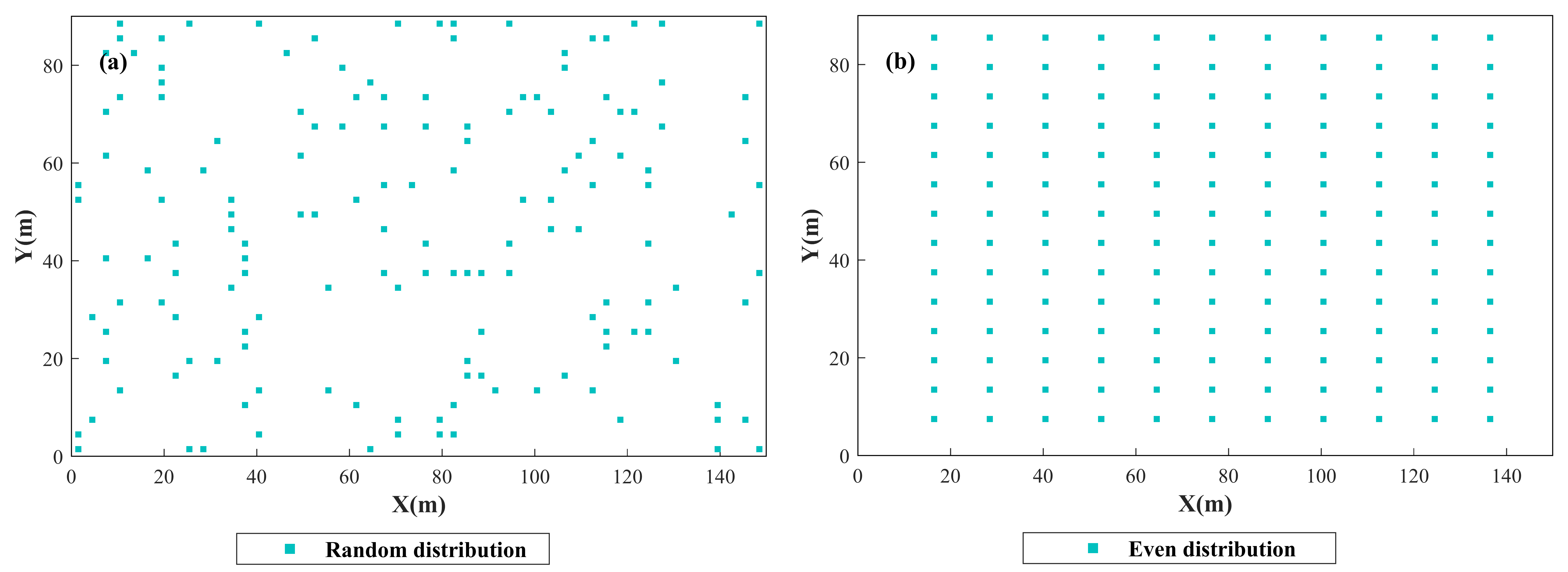
Figure 3. The distribution of pilot points
(a) 154 pilot points with random distribution; (b) 154 pilot points with even distribution

Figure 4. a. The reference hydraulic conductivity field; b-d. The estimated hydraulic conductivity field of Case 1~3; e. The training image of hydraulic conductivity field; f-h. The variance field for the estimated hydraulic conductivity field of Case 1~3.
Table 1. Reference values and prior ranges of contaminant source parameters
Parameters Prior range True values Source location x [L] [10.5 55.5] 28.5 Source location y [L] [16.5 61.5] 43.5 S1(g/s) [45 90] 60 S2(g/s) [43.5 87] 58 S3(g/s) [41.25 82.5] 55 S4(g/s) [37.5 75] 50 S5(g/s) [34.5 69] 46 S6(g/s) [30 60] 40 S7(g/s) [22.5 45] 30 S8(g/s) [15 30] 20  下载: 导出CSV
Table 2. Estimated values of geostatistical parameters for facies with different permeability
Facies with high permeability Facies with low permeability True value Estimated value True value Estimated value Variogram type Exponential Exponential Exponential Exponential Mean 5 4.98 1 1.03 Standard deviation 0.5 0.44 0.5 0.27 Correlation length (x) 10 14 10 18 Correlation length (y) 10 14 10 18
下载: 导出CSV
Table 3. The simulation setting of the case study
Case 1 Case 2 Case 3 Placement mode of pilot point Random distribution Even distribution Even distribution Ensemble size (Ne) of ILUES 1 000 1 000 1 500 Iteration times (Iter) of ILUES 5 5 5
下载: 导出CSV
Table 4. Estimation values of contaminant source parameters
Source Contaminant release concentration of each stress period for Sx Sy SP1 SP2 SP3 SP4 SP5 SP6 SP7 SP8 True value 28.5 43.5 60 58 55 50 46 40 30 20 Case 1 34.4 45.28 61 59.24 64.15 49 48.73 42.82 30.68 20.87 Case 2 29.53 41.28 67.42 63.25 60.45 51.68 51.41 43.4 32.64 21.63 Case 3 31.09 41.36 62.71 66.58 62.36 51.34 50.47 41.9 31.68 20.85
下载: 导出CSV
Table 5. Inverse estimation accuracy of source parameters, hydraulic conductivity at pilot point, hydraulic conductivity field in Case 1~3
Case 1 Case 2 Case 3 RMSE AES RMSE AES RMSE AES Source parameter 3.77 4.11 4.14 4.38 4.19 4.67 Hydraulic conductivity at pilot point 2.08 2.14 1.52 1.56 1.49 1.55 Hydraulic conductivity field 1.95 2.21 1.76 2.09 1.57 2
下载: 导出CSV
-
CAO Zhen-dan, LI Liang-ping, CHEN Kang. 2018. Bridging iterative ensemble smoother and multiple-point geostatistics for better flow and transport modeling. Journal of Hydrology, 565: 411-421. doi: 10.1016/j.jhydrol.2018.08.023 Chen Y, Oliver DS. 2012. Ensemble randomized maximum likelihood method as an itera-tive ensemble smoother. Mathematical Geo-sciences, 44(1): 1-26. http://d.wanfangdata.com.cn/periodical/c207e8f6aeddbce8976da66371cdd132 Emerick AA, Reynolds AC. 2013. Ensemble smoother with multiple data assimilation. Computers & Geosciences, 55: 3-15. http://dl.acm.org/citation.cfm?id=2464411 Evensen G, Van Leeuwen PJ. 2000. An ensemble kalman smoother for nonlinear dynamics. Monthly Weather Review, 128(6): 1852-1867. doi: 10.1175/1520-0493(2000)128<1852:AEKSFN>2.0.CO;2 Gravey M, Mariethoz G. 2020. QuickSampling v1.0: A robust and simplified pixel-based multiple-point simulation approach. Geosci-entific Model Development, 13(6): 2611-2630. Guneshwor L, Eldho TI, Vinod kumar A. 2018. Identification of groundwater contamination sources using meshfree RPCM simulation and particle swarm optimization. Water Resources Management, 32(4): 1517-1538. doi: 10.1007/s11269-017-1885-1 Jha M, Datta B. 2013. Three-dimensional ground-water contamination source identi-fication using adaptive simulated annealing. Journal of Hydrologic Engineering, 18(3): 307-317. doi: 10.1061/(ASCE)HE.1943-5584.0000624 JIANG Si-min, ZAHNG Ya-li, WANG Pei, et al. 2013. An almost-parameter-free harmony search algorithm for groundwater pollution source identification. Water Science and Technology, 68(11): 2359-2366. doi: 10.2166/wst.2013.499 JU Lei, ZHANG Jiang-jiang, MENG Long, et al. 2018. An adaptive Gaussian process-based iterative ensemble smoother for data assimilation. Advances in Water Resources, 115: 125-135. doi: 10.1016/j.advwatres.2018.03.010 LI Li, WANG Yong-gang. 2006. Review of app-lications of geostatistics. Progress in Expora-tion Geophysics, 29(3): 163-169. (in Chinese) http://en.cnki.com.cn/Article_en/CJFDTOTAL-KTDQ200603003.htm LI Liang-ping, Stetler L, CAO Zhen-dan, et al. 2018a. An iterative normal-score ensemble smoother for dealing with non-Gaussianity in data assimilation. Journal of Hydrology, 567: 759-766. doi: 10.1016/j.jhydrol.2018.01.038 LI Liang-ping, Puzel R, Davis A, et al. 2018b. Data assimilation in groundwater modelling: Ensemble Kalman filter versus ensemble smoothers. Hydrological Processes, 32(13): 2020-2029. doi: 10.1002/hyp.13127 LIU Ling-ling, WU Jian-feng, WU Ji-chun, et al. 2009. A comparative study of four geostatistical methods for identifying the hydraulic conductivity fields based on test data. Hydrogeology & Engineering Geology, 36(5): 66-71. (in Chinese) http://en.cnki.com.cn/Article_en/CJFDTotal-SWDG200905017.htm LIU Wen-ting, CHAO LUN Ba-gen, LIU Yan-wei, et al. 2010. Applying geostatistic for the study on spatial variability of coefficient of permeability. Water Conservancy Science and Technology and Economy, 16(4): 364-366. (in Chinese) http://en.cnki.com.cn/Article_en/CJFDTOTAL-SLKY201004004.htm LUO Hong-mei, YANG Pei-jie, WANG Chang-jiang, et al. 2015. Lithofacies simulation based on multi-point geostatistics multiple data joint constraints. Oil Geophysical Pros-pecting, 50(1): 162-169. (in Chinese) http://en.cnki.com.cn/Article_en/CJFDTotal-SYDQ201501031.htm Mariethoz G, Renard P, Straubhaar J, et al. 2010. The Direct sampling method to perform multiple‐point geostatistical simulations. Water Resources Research, 46(11): 1-14. http://www.cabdirect.org/abstracts/20113080508.html;jsessionid=0548407FA58EB53F80C232A33FD8C6A7;jsessionid=B8DC5AD104CC11C440FBB052C79885CE MO Shao-xing, Zabaras N, SHI Xiao-qing, et al. 2019. Deep autoregressive neural net-works for high‐dimensional inverse pro-blems in groundwater contaminant source identification. Water Resources Research, 55(5): 3856-3881. doi: 10.1029/2018WR024638 MO Shao-xing, Zabaras N, SHI Xiao-qing, et al. 2020. Integration of adversarial autoencoders with residual dense convolutional networks for estimation of non-Gaussian hydraulic conductivities. Water Resources Research, 56(2): 1-24. http://arxiv.org/abs/1906.11828?context=stat.ML Ramarao BS, Lavenue AM, DE Marsily G, et al. 1995. Pilot point methodology for automated calibration of an ensemble of conditionally simulated transmissivity fields: 1. Theory and computational experiments. Water Resources Research, 31(3): 475-493. doi: 10.1029/94WR02258 Rezaee H, Mariethoz G, Koneshloo M, et al. 2013. Multiple-point geostatistical simulation using the bunch-pasting direct sampling method. Computers & Geosciences, 54: 293-308. doi: 10.1016/j.cageo.2013.01.020 Straubhaar J, Renard P, Mariethoz G, et al. 2011. An improved parallel multiple-point algorithm using a list approach. Mathematical Geosciences, 43(3): 305-328. doi: 10.1007/s11004-011-9328-7 Strebelle S. 2002. Conditional simulation of complex geological structures using multiple-point statistics. Mathematical Geology, 34(1): 1-21. doi: 10.1023/A:1014009426274 XIA Xue-min, JIANG Si-min, ZHOU Nian-qing, et al. 2019. Genetic algorithm hyper-parameter optimization using taguchi design for ground-water pollution source identification. Water Supply, 19(1): 137-146. doi: 10.2166/ws.2018.059 YANG Ai-lin, JIANG Si-min, LIU Jin-bing, et al. 2020. Groundwater contaminant source identification based on iterative local update ensemble smoother. Journal of Groundwater Science and Engineering, 8(1): 1-9. doi: 10.19637/j.cnki.2305-7068.2020.01.001 YANG Pei-jie. 2014. Geostatistics inversion- from two-point to multiple-point. Progress in Geophysics, 29(5): 2293-2300. (in Chinese) http://en.cnki.com.cn/Article_en/CJFDTOTAL-DQWJ201405045.htm ZHANG Jiang-jiang, LIN Guang, LI Wei-xuan, et al. 2018. An iterative local updating en-semble smoother for estimation and un-certainty assessment of hydrologic model parameters with multimodal distributions. Water Resources Research, 54(3): 1716-1733. doi: 10.1002/2017WR020906 ZONG Cheng-yuan, KANG Xue-yuan, SHI Xiao-qing, et al. 2020. Characterization of non-Gaussian hydraulic conductivity fields using multiple-point geostatistics and ensemble smoother with multiple data assimilation method. Hydrogeology & Engineering Geology, 47(02): 1-8. (in Chinese) -


 点击查看大图

计量
- 文章访问数: 1881
- HTML全文浏览量: 879
- PDF下载量: 62
- 被引次数: 0


