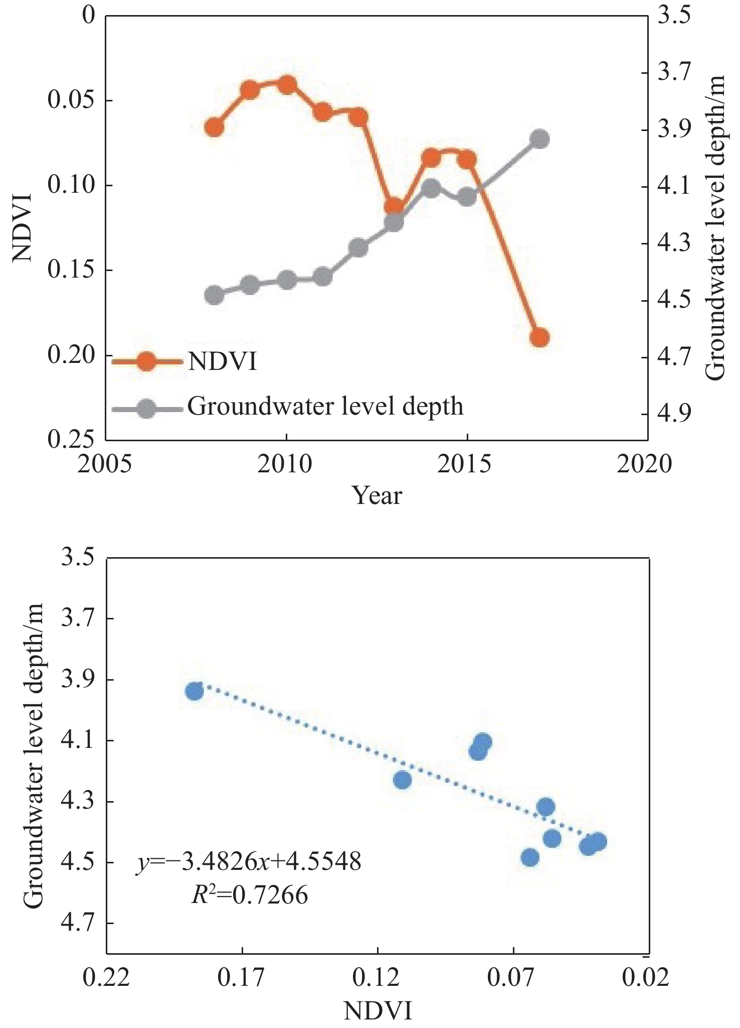
• ISSN 2305-7068
  • Indexed by ESCI CABI CAS
  • DOAJ Scopus GeoRef AJ CNKI
Advanced Search

2021 Vol. 9, No. 4

Display Method:
Assessment of porous aquifer hydrogeological parameters using automated groundwater level measurements in Greece
Marios C Kirlas
2021, 9(4): 269-278. doi: 10.19637/j.cnki.2305-7068.2021.04.001
Abstract(3481) FullText HTML (1668) PDF(151)
Abstract:
In this paper, the hydrogeological parameters of a confined aquifer, such as transmissivity (T), storativity (S) and radius of influence (R), have been assessed using real groundwater level measurements recorded by a monitoring network, consisting of automated municipal water supply boreholes at Nea Moudania aquifer, Chalkidiki, Greece. Particularly, the paper focused on the correlation between the drawdown and the constant flow rate during pumping time. So the Cooper-Jacob and the recovery test method were applied in order to delineate if turbulent head losses occur, as well as the impact of incorrect measurements of the radial distance (r) in the accuracy of estimating S values. The results show that a) the occurrence of a linear correlation between s and Q indicates a negligible turbulent head loss in the pumping wells and thus a reasonable flow rate usage, b) the validity of storativity values could be compromised if the r value is not accurately measured, and c) recovery test method can be used as an indicator of residual drawdown (s’) caused by previous pumping cycles, when the straight line intersecting the logarithmic t/t’ axis has a value greater than 1.
Potential assessment of CO2 geological storage based on injection scenario simulation: A case study in eastern Junggar Basin
Xin Ma, Dong-guang Wen, Guo-dong Yang, Xu-feng Li, Yu-jie Diao, Hai-hai Dong, Wei Cao, Shu-guo Yin, Yan-mei Zhang
2021, 9(4): 279-291. doi: 10.19637/j.cnki.2305-7068.2021.04.002
Abstract(1017) FullText HTML (410) PDF(67)
Abstract:
Carbon Capture and Storage (CCS) is one of the effective means to deal with global warming, and saline aquifer storage is considered to be the most promising storage method. Junggar Basin, located in the northern part of Xinjiang and with a large distribution area of saline aquifer, is an effective carbon storage site. Based on well logging data and 2D seismic data, a 3D heterogeneous geological model of the Cretaceous Donggou Formation reservoir near D7 well was constructed, and dynamic simulations under two scenarios of single-well injection and multi-well injection were carried out to explore the storage potential and CO2 storage mechanism of deep saline aquifer with real geological conditions in this study. The results show that within 100 km2 of the saline aquifer of Donggou Formation in the vicinity of D7 well, the theoretical static CO2 storage is 71.967 × 10⁶ tons (P50), and the maximum dynamic CO2 storage is 145.295 × 10⁶ tons (Case2). The heterogeneity of saline aquifer has a great influence on the spatial distribution of CO2 in the reservoir. The multi-well injection scenario is conducive to the efficient utilization of reservoir space and safer for storage. Based on the results from theoretical static calculation and the dynamic simulation, the effective coefficient of CO2 storage in deep saline aquifer in the eastern part of Xinjiang is recommended to be 4.9%. This study can be applied to the engineering practice of CO2 sequestration in the deep saline aquifer in Xinjiang.
Determination of groundwater solute transport parameters in finite element modelling using tracer injection and withdrawal testing data
Van Hoang Nguyen
2021, 9(4): 292-303. doi: 10.19637/j.cnki.2305-7068.2021.04.003
Abstract(504) FullText HTML (180) PDF(52)
Abstract:
The groundwater tracer injection and withdrawal tests are often carried out for the determination of aquifer solute transport parameters. However, the parameter analyses encounter a great difficulty due to the radial flow nature and the variability of the temporal boundary conditions. An adaptive methodology for the determination of groundwater solute transport parameters using tracer injection and withdrawal test data had been developed and illustrated through an actual case. The methodology includes the treatment of the tracer boundary condition at the tracer injection well, the normalization of tracer concentration, the groundwater solute transport finite element modelling and the method of least squares to optimize the parameters. An application of this methodology was carried out in a field test in the South of Hanoi city. The tested aquifer is Pleistocene aquifer, which is a main aquifer and has been providing domestic water supply to the city since the French time. Effective porosity of 0.31, longitudinal dispersivity of 2.2 m, and hydrodynamic dispersion coefficients from D = 220 m2/d right outside the pumping well screen to D =15.8 m2/d right outside the tracer injection well screen have been obtained for the aquifer at the test site. The minimal sum of squares of the differences between the observed and model normalized tracer concentration is 0.00119, which is corresponding to the average absolute difference between observed and model normalized concentrations of 0.035 5 (while 1 is the worst and 0 is the best fit).
Arsenic contamination caused by roxarsone transformation with spatiotemporal variation of microbial community structure in a column experiment
Ya-ci Liu, Zhao-ji Zhang, Xin-yi Zhao, Meng-tuo Wen, Sheng-wei Cao, Ya-song Li
2021, 9(4): 304-316. doi: 10.19637/j.cnki.2305-7068.2021.04.004
Abstract(1295) FullText HTML (575) PDF(46)
Abstract:
Arsenic contamination from roxarsone in livestock manure is common, and livestock manure continuously accumulates in the open environment. Evaluations of the environmental processes of As mobilization and transformation are critical for predicting the fate of As compounds after roxarsone degradation. In this study, spatiotemporal variations in As species and microbial community structure were characterized using laboratory column experiments with background soil collected from Yanggu County (northern Shandong Plain, China), a region of intense poultry production. Organic and inorganic arsenic were detected by high-performance liquid chromatography (HPLC) and HPLC with hydride generation atomic fluorescence spectrometry (HPLC-HG-AFS), respectively. High-throughput sequencing technology was used to describe microbial diversity. Results showed that roxarsone was transformed completely within 7 days, and As(Ⅲ) and As(Ⅴ) were the major degradation products. The concentration of As(Ⅲ) was much lower than that of As(Ⅴ). The As(Ⅲ) concentration increased significantly after Day 14, whereas the As(Ⅴ) concentration increased significantly after Day 84, indicating that As(Ⅲ) was initially produced. The microbial community structure changed significantly as roxarsone transformed into various As compounds. A critical and dominant bacterial strain, norank_f__Family_XVⅢ, was found to be related to the degradation of roxarsone into As(Ⅲ). This study improves our understanding of the fate of As species released from poultry litter to soil and groundwater, which is a threat to human health and environment.
Extenuating the parameters using HEC-HMS hydrological model for ungauged catchment in the central Omo-Gibe Basin of Ethiopia
Habtamu Semunigus Demisse, Abebe Temesgen Ayalew, Melkamu Teshome Ayana, Tarun Kumar Lohani
2021, 9(4): 317-325. doi: 10.19637/j.cnki.2305-7068.2021.04.005
Abstract(645) FullText HTML (262) PDF(67)
Abstract:
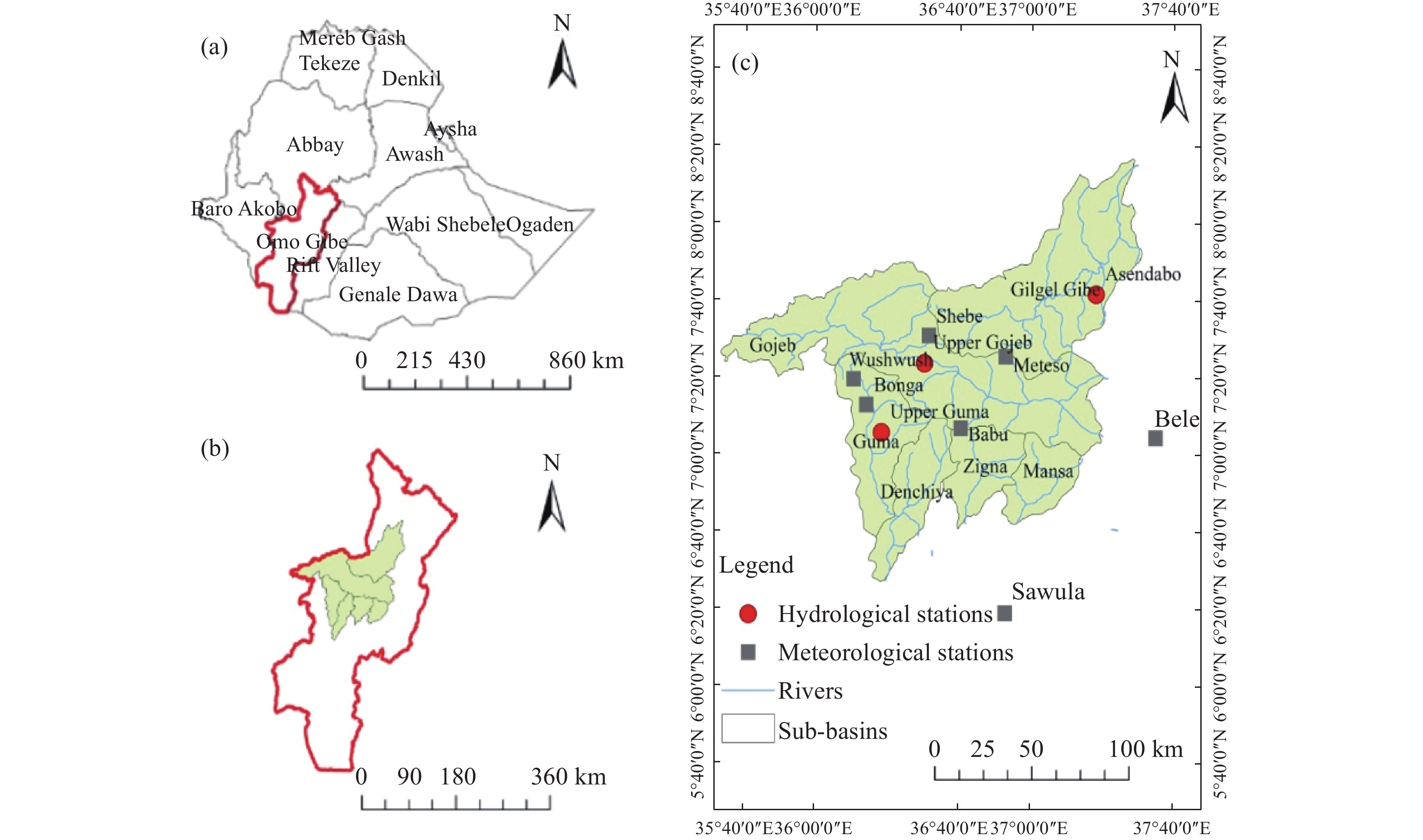
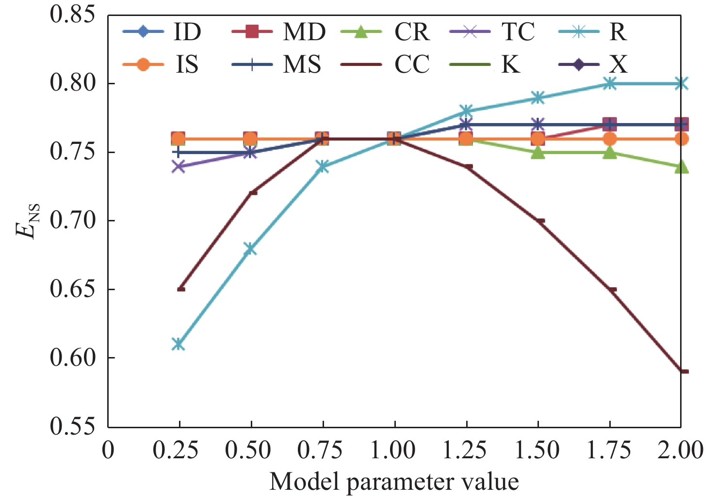
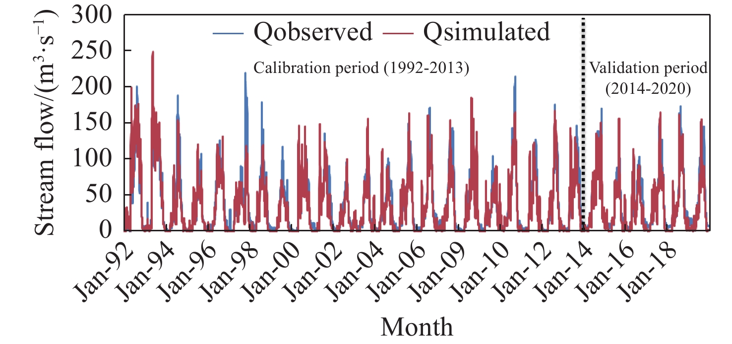
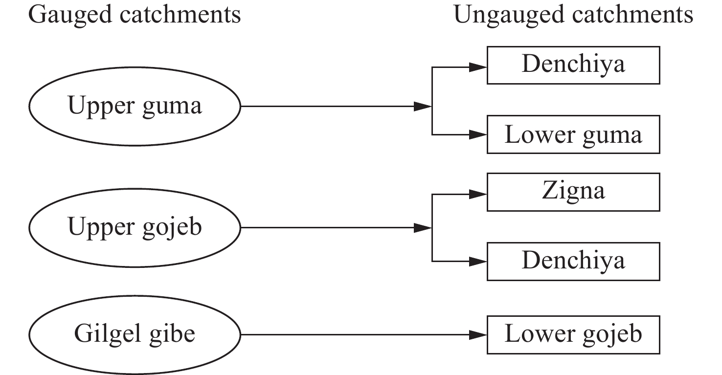
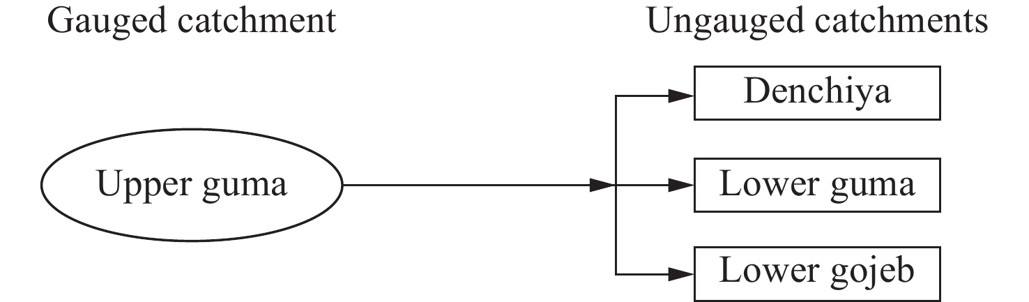
Characteristics of ungauged catchments can be studied from the hydrological model parameters of gauged catchments. In this research, discharge prediction was carried out in ungauged catchments using HEC-HMS in the central Omo-Gibe basin. Linear regression, spatial proximity, area ratio, and sub-basin mean were amalgamated for regionalization. The regional model parameters of the gauged catchment and physical characteristics of ungauged catchments were collated together to develop the equations to predict discharge from ungauged catchments. From the sensitivity analysis, crop coefficient (CC), storage coefficient (R), constant rate (CR), and time of concentration (TC) are found to be more sensitive than others. The model efficiency was evaluated using Nash–Sutcliffe Efficiency (NSE) which was greater than 0.75, varying between −10% and +10% and the coefficient of determination (R2) was approximated to be 0.8 during the calibration and validation period. The model parameters in ungauged catchments were determined using the regional model (linear regression), sub-basin mean, area ratio, and spatial proximity methods, and the discharge was simulated using the HEC-HMS model. Linear regression was used in the prediction where p-value ≤ 0.1, determination coefficient (R2) = 0.91 for crop coefficient (CC) and 0.99 for maximum deficit (MD). Constant rate (CR), maximum storage (MS), initial storage (IS), storage coefficient (R), and time of concentration (TC) were obtained. The result is that an average of 30 m3/s and 15 m3/s as the maximum monthly simulated flow for ungauged sub-catchments, i.e. Denchiya and Mansa of the main river basin .
Comprehensive evaluation on the ecological function of groundwater in the Shiyang River watershed
Min Liu, Zhen-long Nie, Le Cao, Li-fang Wang, Hui-xiong Lu, Zhe Wang, Pu-cheng Zhu
2021, 9(4): 326-340. doi: 10.19637/j.cnki.2305-7068.2021.04.006
Abstract(504) FullText HTML (195) PDF(49)
Abstract:
With an arid climate and shortage of water resources, the groundwater dependent ecosystems in the oasis–desert ecotone of the Shiyang River Watershed has been extremely damaged, and the water crisis in the oasis has become a major concern in the social and the scientific community. In this study, the degeneration characteristics of the groundwater ecological function was identified and comprehensive evaluated, based on groundwater depth data, vegetation quadrat and normalized difference vegetation index (NDVI) from Landsat program. The results showed that (1) the suitable groundwater depth for sustainable ecology in the Shiyang River Watershed is about 2-4 m; (2) the terms of degenerative, qualitative and disastrous stages of the groundwater ecological function are defined with the groundwater depths of about 5 m, 7 m and 10 m; (3) generally, the groundwater ecological function in the oasis-desert ecotone of the lower reaches of Shiyang River Watershed is weak with an area of 1 397.9 km2 identified as the severe deterioration region, which accounted 74.7% of the total area. In the meantime, the percentages of the good, mild and moderate deterioration areas of groundwater ecological function are 3.5%, 5.5% and 16.3%, respectively, which were mainly distributed in the Qingtu lake area and the southeastern area of the Shoucheng town; (4) the degradation and shrinkage of natural oasis could be attributed to the dramatic groundwater decline, which is generally caused by irrational use of water and soil resources. This study could provide theoretical basis and scientific support for the decision-making in environmental management and ecological restoration of the Shiyang River Watershed.
The relationship between groundwater and natural vegetation in Qaidam Basin
Xue-ya Dang, Na Lu, Xiao-fan Gu, Xiao-mei Jin
2021, 9(4): 341-349. doi: 10.19637/j.cnki.2305-7068.2021.04.007
Abstract(405) FullText HTML (212) PDF(50)
Abstract:
To accurately evaluate ecological risks trigged by groundwater exploitation, it must be clarified the relationship between vegetation and groundwater. Based on remote sensing data sets MOD13Q1, groundwater table depth (WTD) and total dissolved solids (TDS), the relationship between groundwater and natural vegetation was analyzed statistically in the main plain areas of Qaidam Basin. The results indicate that natural vegetation is groundwater-dependent in areas where WTD is less than 5.5 m and TDS is less than 7.5 g/L. Aquatic vegetation, hygrophytic vegetation and hygrophytic saline-alkali tolerant vegetation are mainly distributed in areas with WTD <1.1 m. Salt-tolerant and mesophytic vegetation mainly occur in areas with WTD of 1.4-3.5 m, while the xerophytic vegetation isprimarily present in areas where WTD ranges from 1.4 m to 5.5 m. Natural vegetation does not necessarily depend on groundwater in areas with WTD >5.5 m. For natural vegetation, the most suitable water TDS is less than 1.5 g/L, the moderately suitable TDS is 1.5-5.0 g/L, the basically suitable TDS is 5.0-7.5 g/L, and the unsuitable TDS is more than 7.5 g/L.
Analysis on the situation and countermeasures of water resources supply and demand in the cities of small and medium-sized river basins along southeast coast of China — taking Xiamen City as an example
Chun-lei Liu, Jian-hua Zheng, Zheng-hong Li, Ya-song Li, Qi-chen Hao, Jian-feng Li
2021, 9(4): 350-358. doi: 10.19637/j.cnki.2305-7068.2021.04.008
Abstract(556) FullText HTML (189) PDF(40)
Abstract:
The small and medium-sized river basins along southeast coast of China hold comparatively abundant water resources. However, the rapid resources urbanization in recent years has produced a series of water problems such as deterioration of river water quality, water shortage and exacerbated floods, which have constrained urban economic development. By applying the principle of triple supply-demand equilibrium, this paper focuses on the estimation of levels of water supply and demand in 2030 at different guarantee probabilities, with a case study of Xiamen city. The results show that water shortage and inefficient utilization are main problems in the city, as the future water supply looks daunting, and a water shortage may hit nearly 2 × 10⁸ m3 in an extraordinarily dry year. Based on current water supply-demand gap and its trend, this paper proposes countermeasures and suggestions for developing and utilizing groundwater resources and improving the utilization rate of water resources, which can supply as a reference for other southeast middle-to-small-sized basin cities in terms of sustainable water resources and water environment protection.
Ecological function zoning and protection of groundwater in Asia
Xue-ru Wen, Yan-pei Cheng, Jian-kang Zhang, Hua Dong
2021, 9(4): 359-368. doi: 10.19637/j.cnki.2305-7068.2021.04.009
Abstract(451) FullText HTML (166) PDF(40)
Abstract:
The natural groundwater recharge in Asia is estimated to be 4 677.74×10⁹ m3/a. However, it features extremely uneven spatial-temporal distribution. Groundwater is distributed in various natural and geological environments, and it is liable to be affected by numerous factors and possesses different properties. Moreover, groundwater faces complex ecological problems. This paper gains a complete understanding of groundwater in Asia in terms of the structure of aquifer systems, the processes of groundwater cycle, and the spatial variation laws of surface ecosystems. Based on this, it proposes the ecological function zoning scheme of groundwater in Asia, aiming to provide guidance for the utilization of regional water resources and the planning for economic and social development, coordinate the relationship between social and economic development and water resource protection, and improve the ecological functions of groundwater. Furthermore, this paper analyzes the problems with regional groundwater management in Asia and puts forward countermeasures and suggestions, thus providing a theoretical basis for the sustainable development and utilization of regional groundwater and environmental protection.

Welcome to Journal of Groundwater Science and  Engineering!

Quick Submit

Online Submission   E-mail Submission