• ISSN 2305-7068
  • Indexed by ESCI CABI CAS
  • DOAJ Scopus GeoRef AJ CNKI
Advanced Search

2023 Vol. 11, No. 3

Display Method:
Research Paper
Changes in groundwater resources and their influencing factors in Songnen Plain, China
Qiang Liu, Xiao-dong Guo, Chang-qi Wang, Nan Lin, Hui-rong Zhang, Lin Chen, Yan Zhang
2023, 11(3): 207-220. doi: 10.26599/JGSE.2023.9280018
Abstract(548) FullText HTML (270) PDF(96)
Abstract:
The Songnen Plain is a crucial agricultural area in China, and in the past 20 years, a large number of dry fields have been developed into paddy fields in order to improve land output efficiency. As a result, the effective irrigation area of agriculture has increased annually, and the conversion mode and quantity between surface water and groundwater have changed considerably. It is essential to identify the changes in groundwater resources and their influencing factors for the sustainable development of economy and society. This study evaluates groundwater resources in the Songnen Plain using the water balance method based on meteorological, hydrological and groundwater monitoring data from 2000 to 2020. The results show that the groundwater resources in the region amount to 15.945 billion m3 with precipitation infiltration being the most important component, accounting for 73.09%, which is followed surface water irrigation infiltration and river and ditch infiltration, constituting 14.55% and 10.32%, respectively. Different factors influence groundwater resources in different periods. Compared to 1985, the increase of surface water irrigation infiltration is the primary factor responsible for the increase of groundwater resources, while other recharge sources have decreased during the same period. Compared to 2005, all groundwater resources have increased, with the increase of surface water irrigation infiltration and river channel infiltration being the primary factors.
Application of GIS based analytical hierarchy process and multicriteria decision analysis methods to identify groundwater potential zones in Jedeb Watershed, Ethiopia
Temesgen Mekuriaw Manderso, Yitbarek Andualem Mekonnen, Tadege Aragaw Worku
2023, 11(3): 221-236. doi: 10.26599/JGSE.2023.9280019
Abstract(320) FullText HTML (173) PDF(66)
Abstract:
The hydrogeological situation of the study area requires the identification of groundwater potential. Remote sensing and satellite data have proven to be reliable tools for understanding various factors that affect groundwater occurrence and movement. This study employed weighted overlay analysis based on satellite imagery and secondary data to create a thematic map for characterizing groundwater potentials in the study area located within Abbay Basin, Ethiopia. Remote sensing (RS) and GIS-based Fuzzy-Analytical Hierarchy Process methods were utilized to classify groundwater potential (GWP) zones into five categories: Very good, good, moderate, poor, and very poor. The central and eastern parts of the study area were identified as having high (33.186%) and very high (2.351%) groundwater potentials, while the western part exhibited poor and very poor potential areas. The groundwater potential map delineated higher and moderate potentials, suitable for installing shallow and production bores. This research demonstrates the effectiveness of RS and GIS techniques for delineating groundwater potential zones, which can aid in the planning and management of groundwater resources. The research findings have the potential to contribute to the formulation of improved groundwater management programs in the study area.
Geothermal anomalies in the Xianshuihe area: Implications for tunnel construction along the Sichuan-Tibet Railway, China
Feng Liu, Wei Zhang, Gui-ling Wang, Shuai-chao Wei, Chen Yue, Guang-zheng Jiang, Yu-zhong Liao
2023, 11(3): 237-248. doi: 10.26599/JGSE.2023.9280020
Abstract(244) FullText HTML (117) PDF(28)
Abstract:
This study presents a comprehensively analysis of geothermal characteristics in the Xianshuihe geothermal area along the Sichuan-Tibet Railway, using temperature logging, temperature monitoring and thermal conductivity measurement, and regional geothermal geological survey data. The research focuses on the geothermal background, geothermal field, and their potential impact on the surrounding tunnels. The investigation reveals that the average heat flow value in the study area is approximately 73.0 mW/m2, significantly higher than the average terrestrial heat flow in mainland China (​​62.5 mW/m2). This high terrestrial heat flow signifies a distinct thermal background in the area. In addition, geothermal anomalies in the area are found to be closely associated with the distribution of hot springs along NW faults, indicating a strong control by the Xianshuihe fault zone. The study concludes that the region's favorable conditions for geothermal resources are attributed to the combination of high terrestrial heatflow background and water-conducting faults. However, these conditions also pose a potential threat of heat damage to the tunnels along the Sichuan-Tibet Railway. To evaluate the risk, the research takes into account the terrestrial heat flow, thermal conductivity of the tunnel surrounding rocks, characteristics of the regional constant temperature layer, as well as the distribution of hot springs and faults. The analysis specifically focuses on the thermal damage risk of Kangding 1# tunnel and 2# tunnel passing through the study area. Based on the findings, it is determined that Kangding 1# tunnel and 2# tunnel have relatively low risk of heat damage, as they have avoided most of the high temperature anomaly areas. However, several sections of the tunnels do traverse zones with low to medium temperatures, where surface rock temperatures can reach up to 45°C. Therefore, these regions should not be neglected during the construction and operation of the tunnel project, and mitigation measures may be necessary to address the potential heat-related challenges in the area.
Determination of groundwater potential distribution in Kulfo-Hare watershed through integration of GIS, remote sensing, and AHP in Southern Ethiopia
Edmealem Temesgen, Demelash Wendmagegnehu Goshime, Destaw Akili
2023, 11(3): 249-262. doi: 10.26599/JGSE.2023.9280021
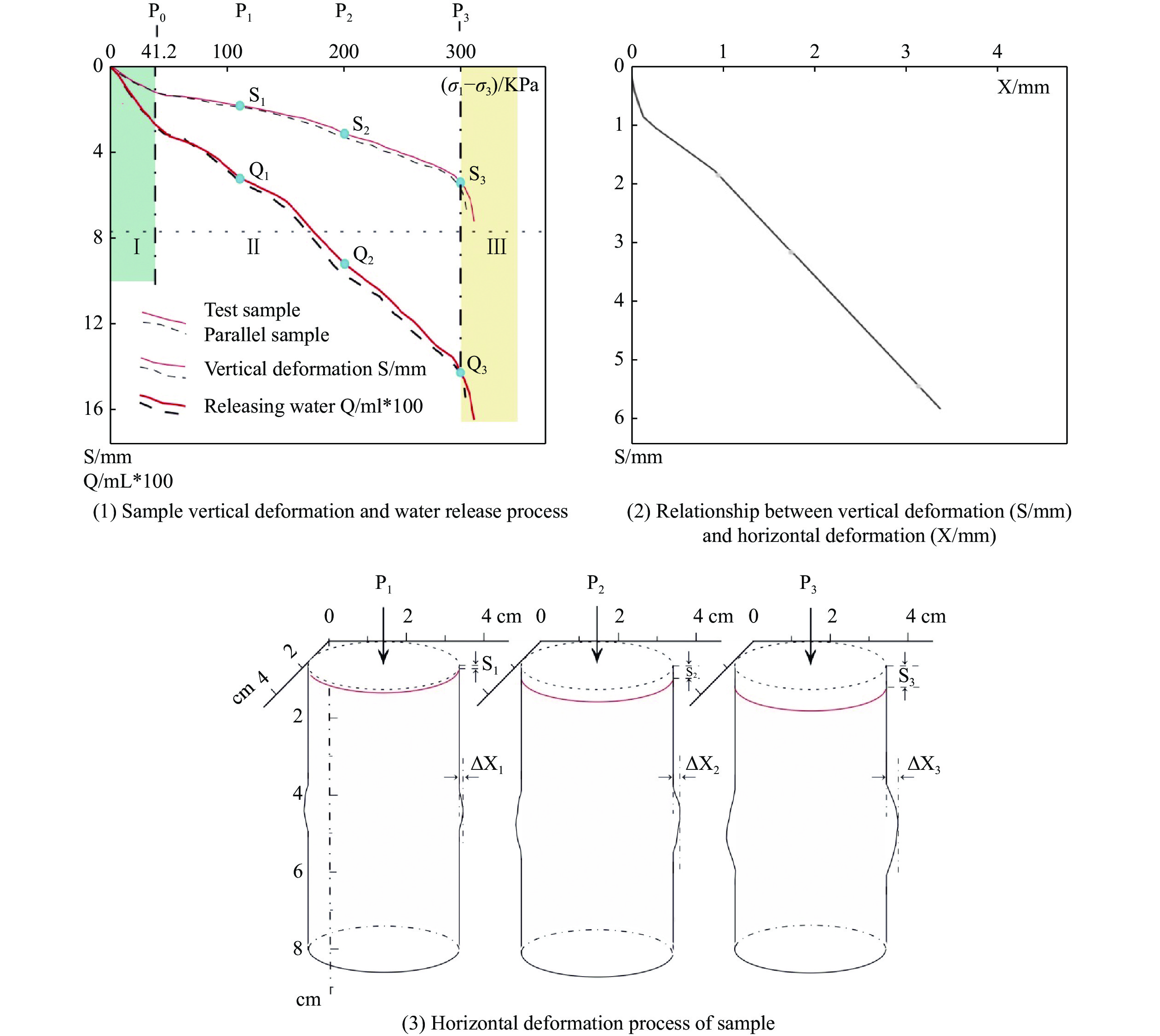
Abstract(306) FullText HTML (160) PDF(56)
Abstract:
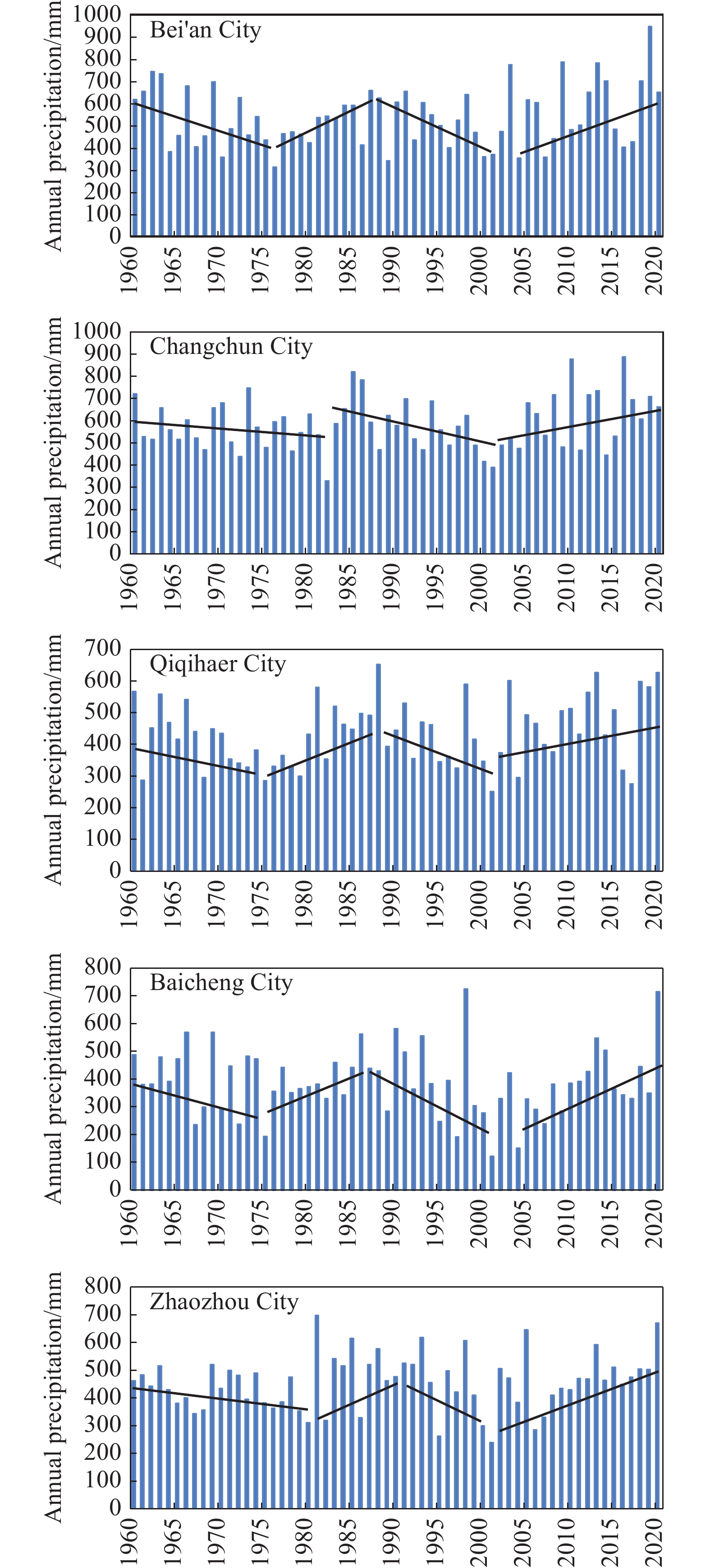
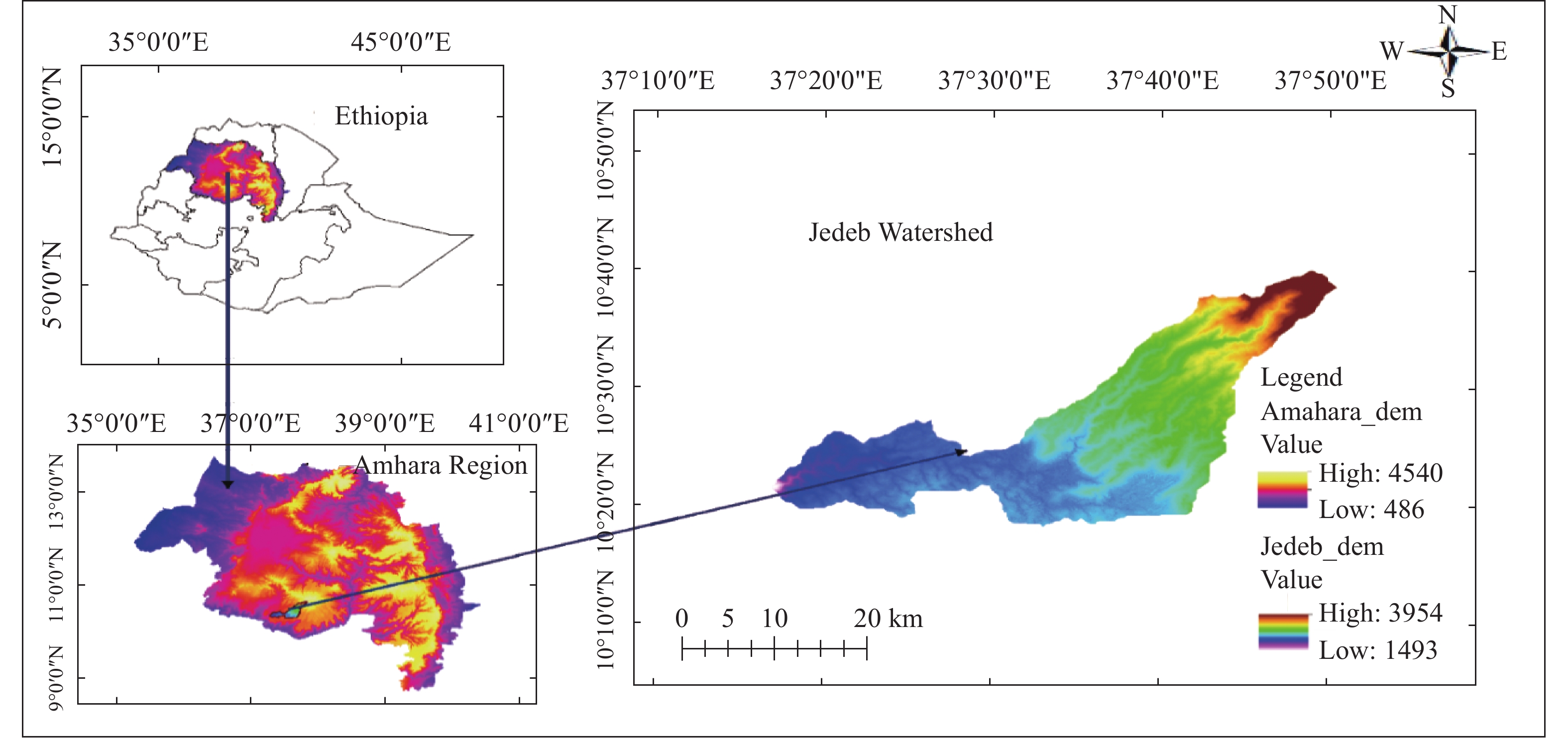
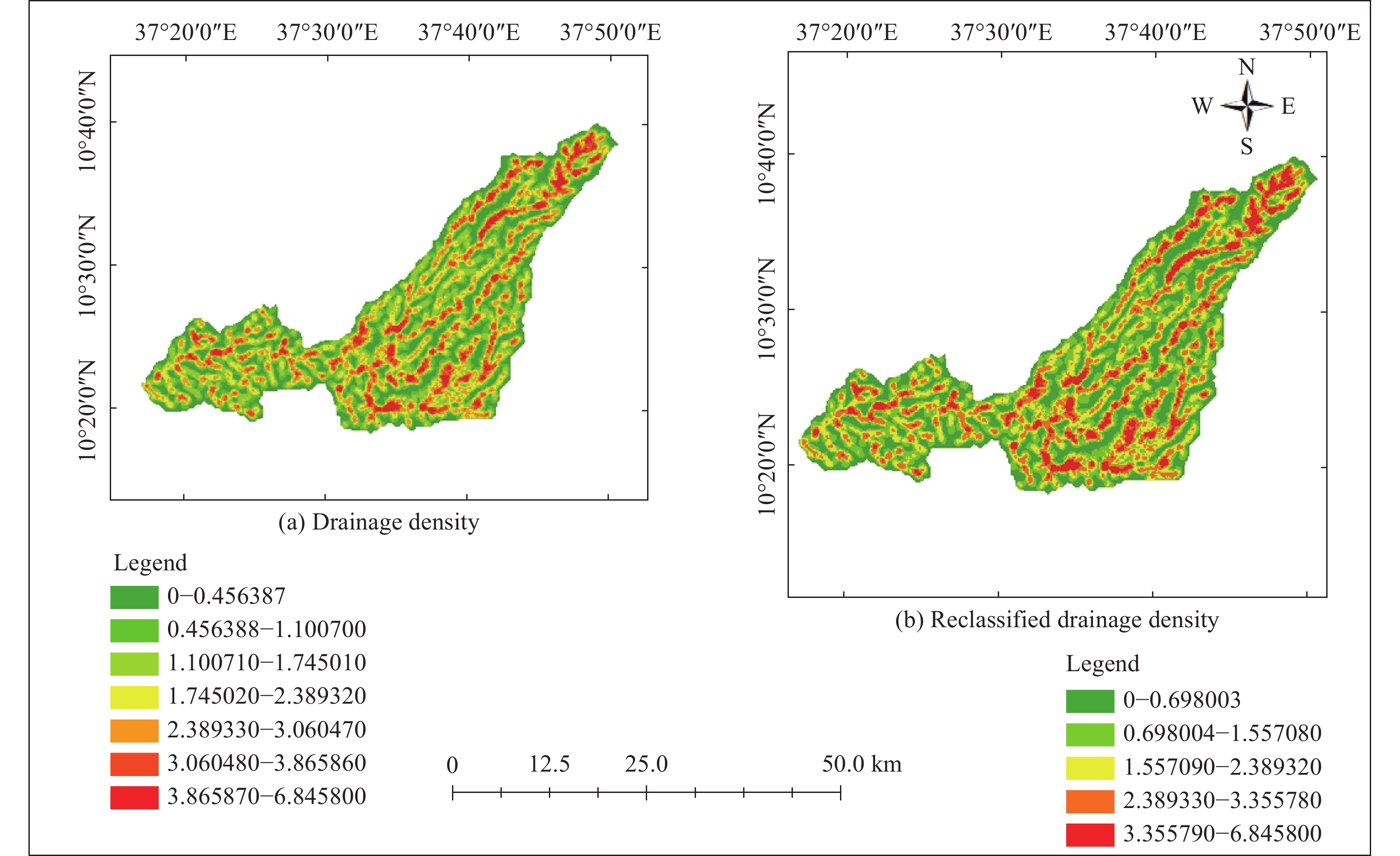
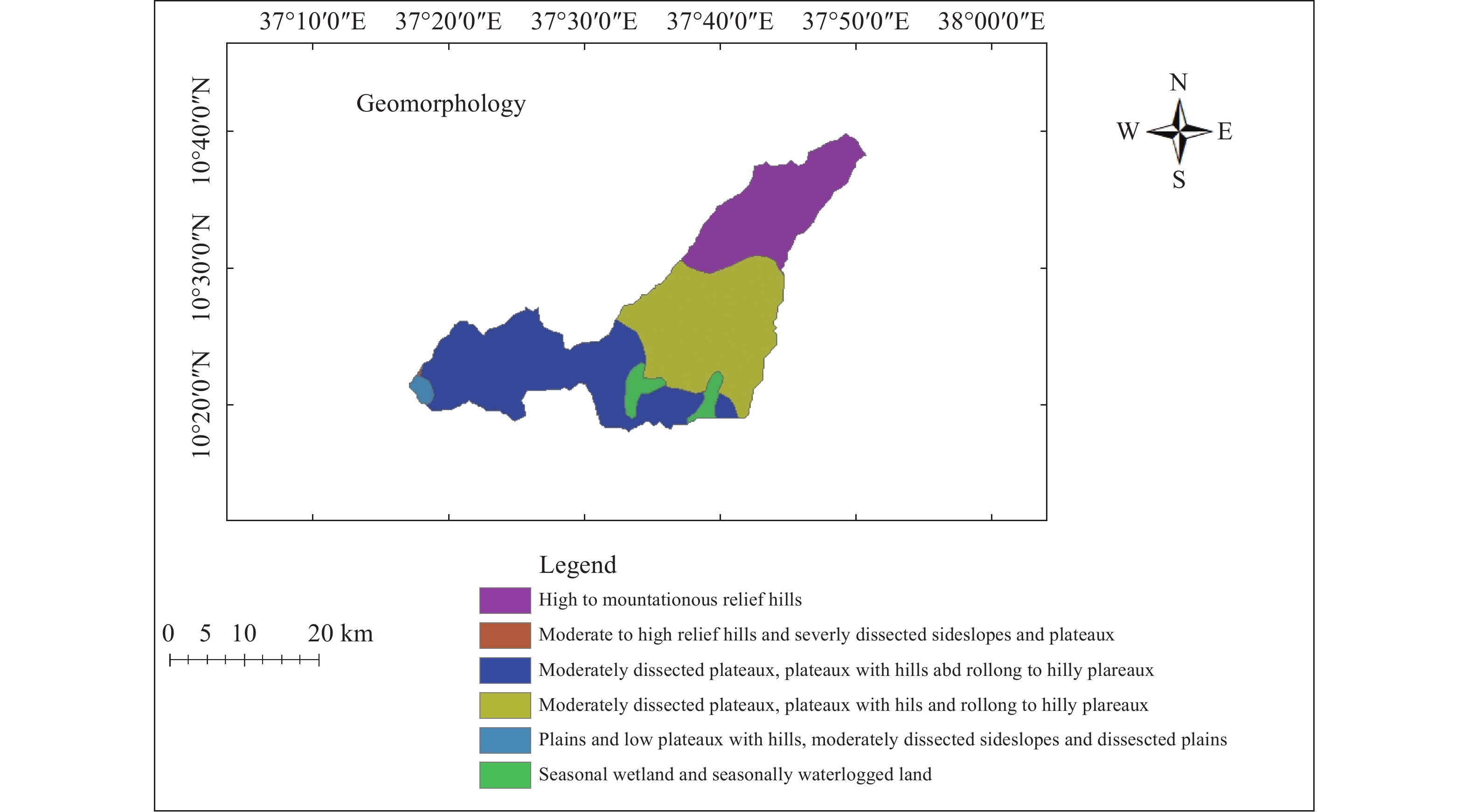
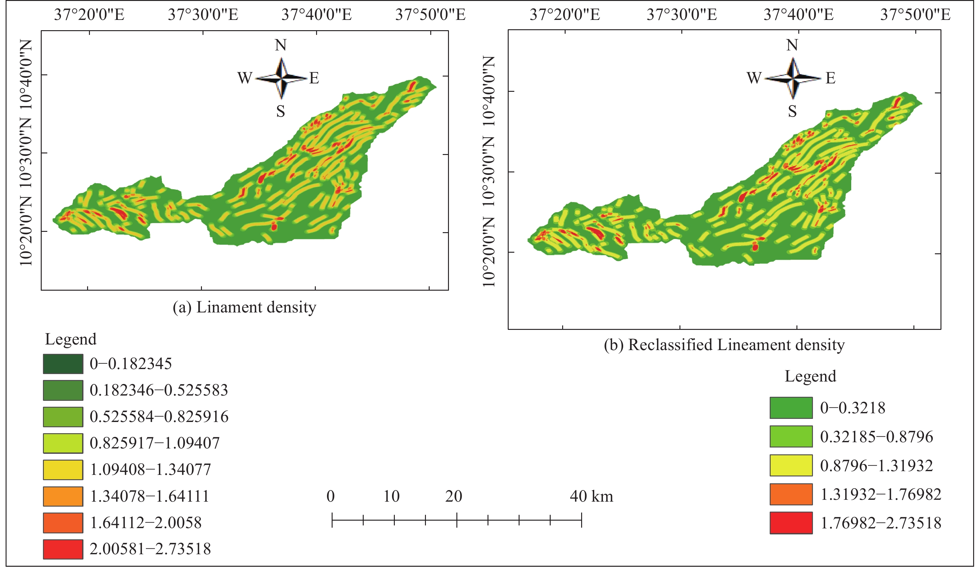
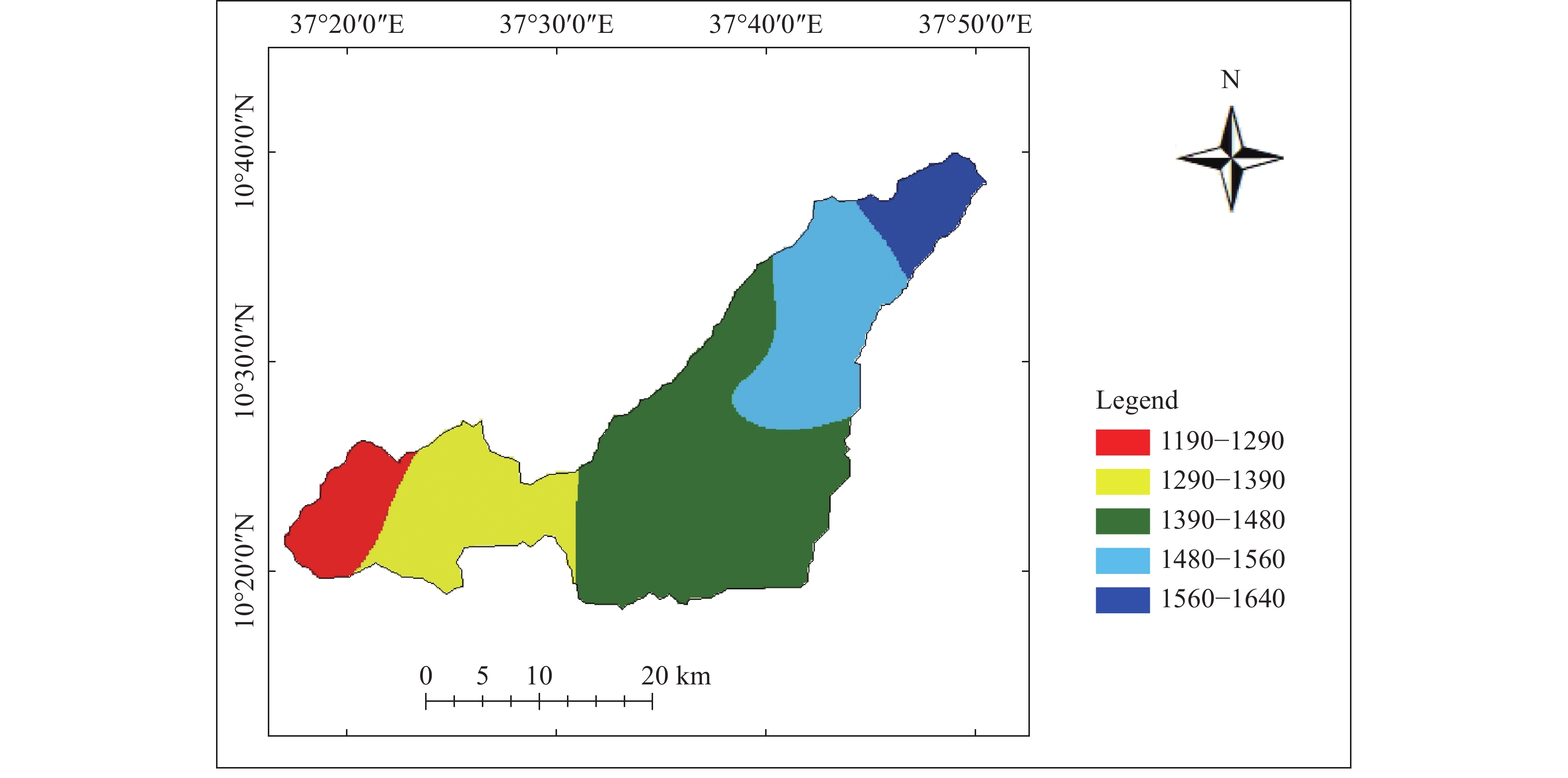
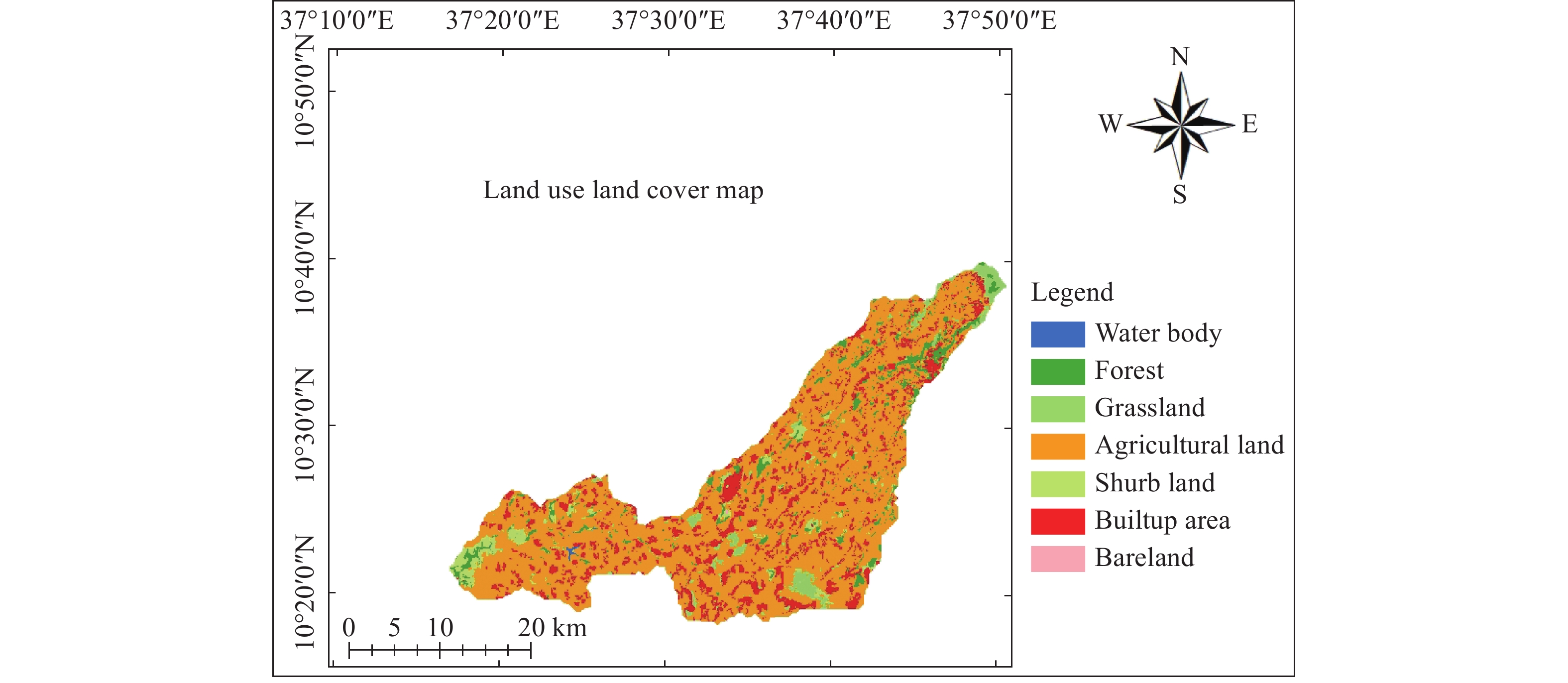
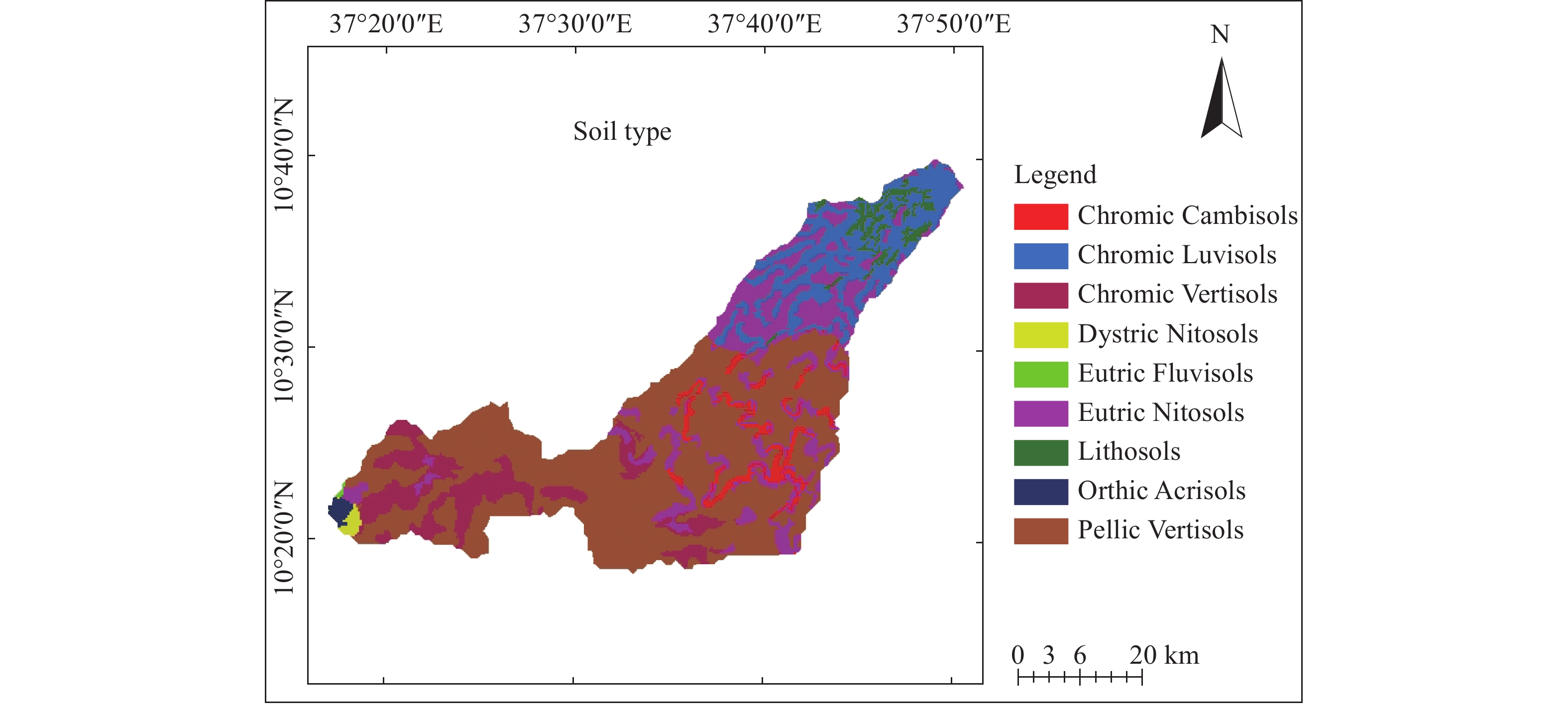
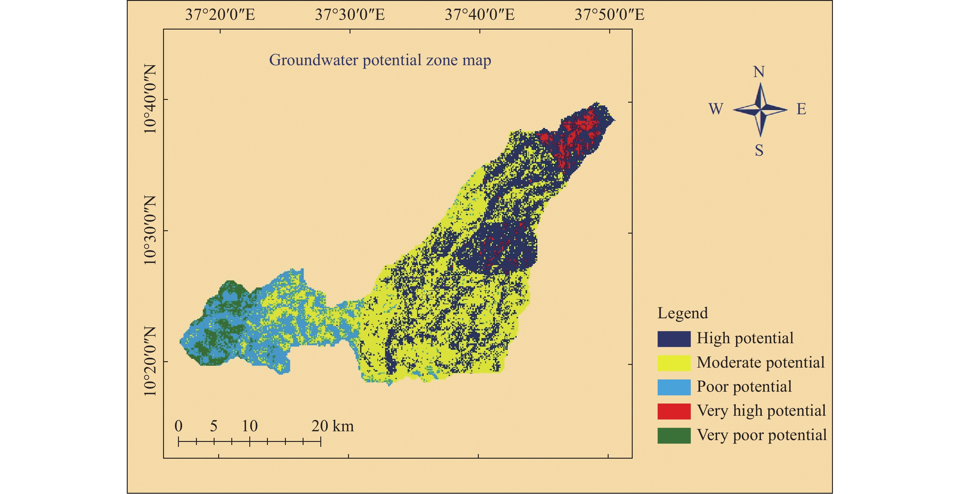
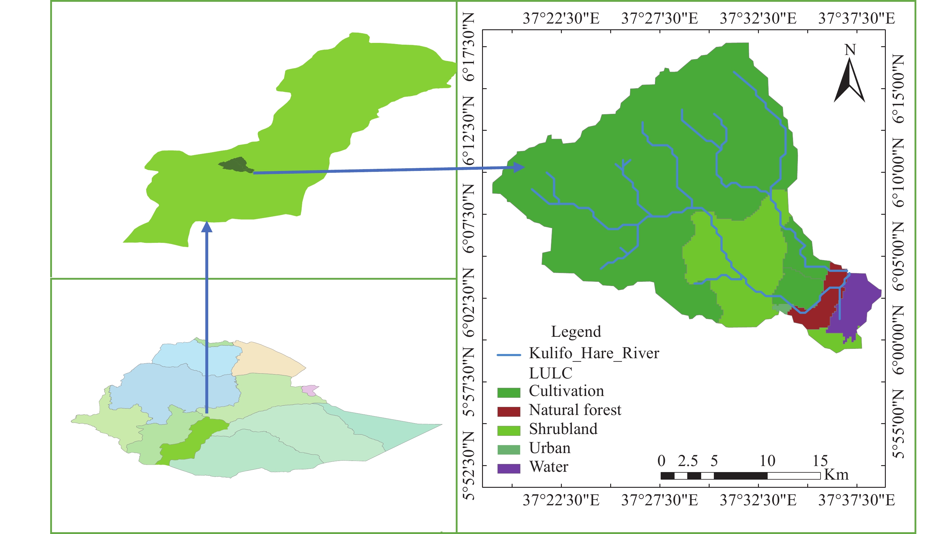
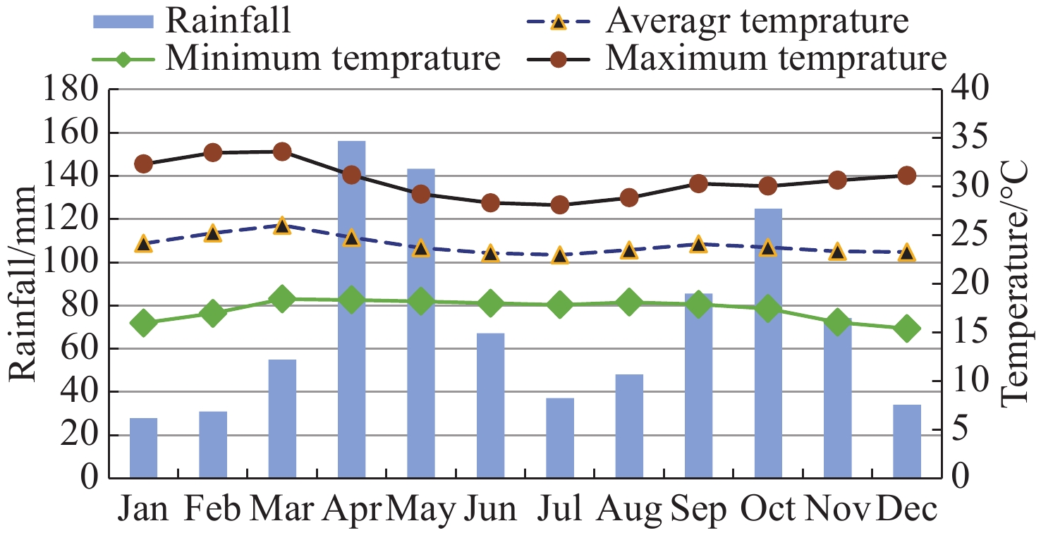
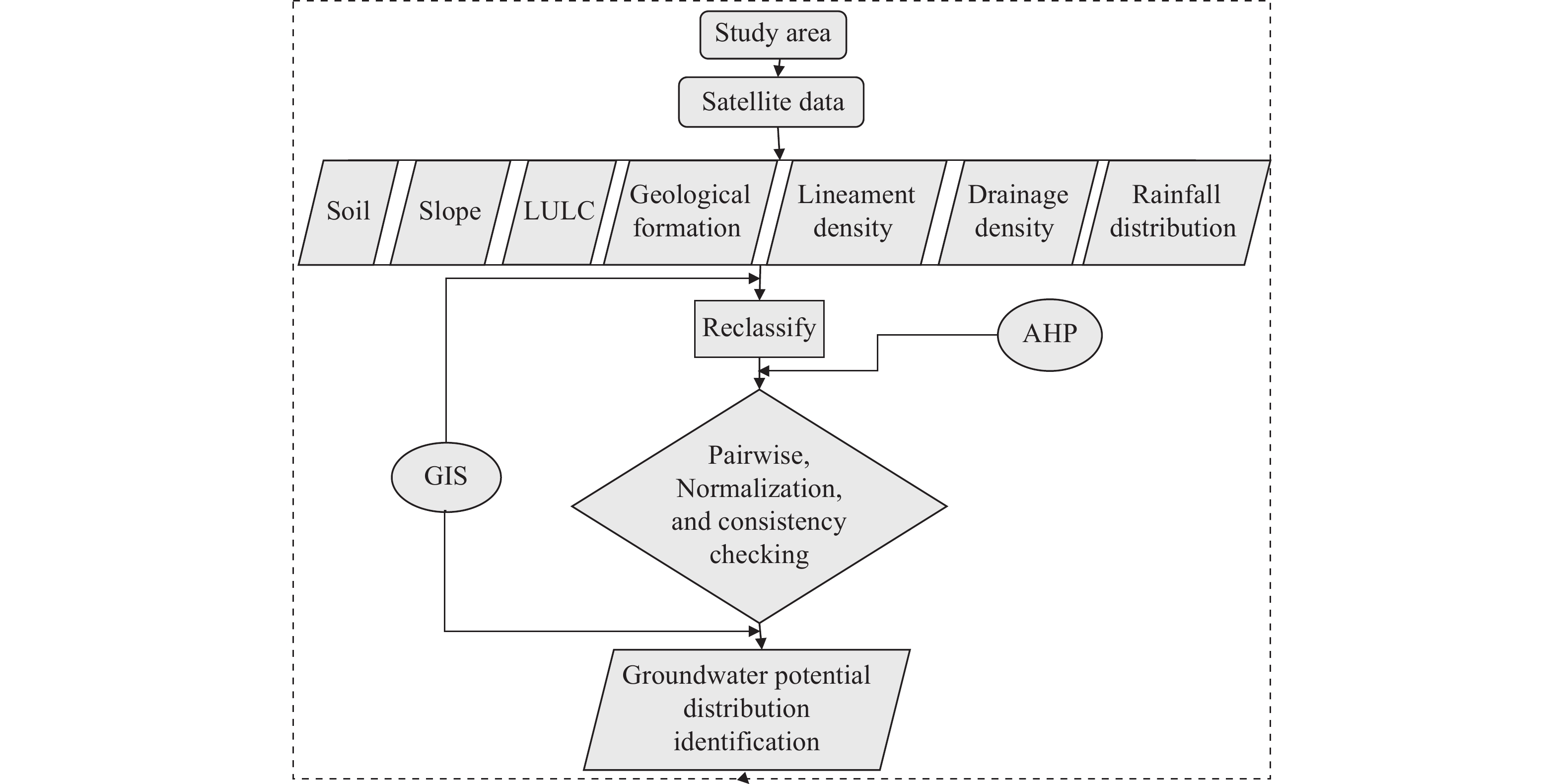
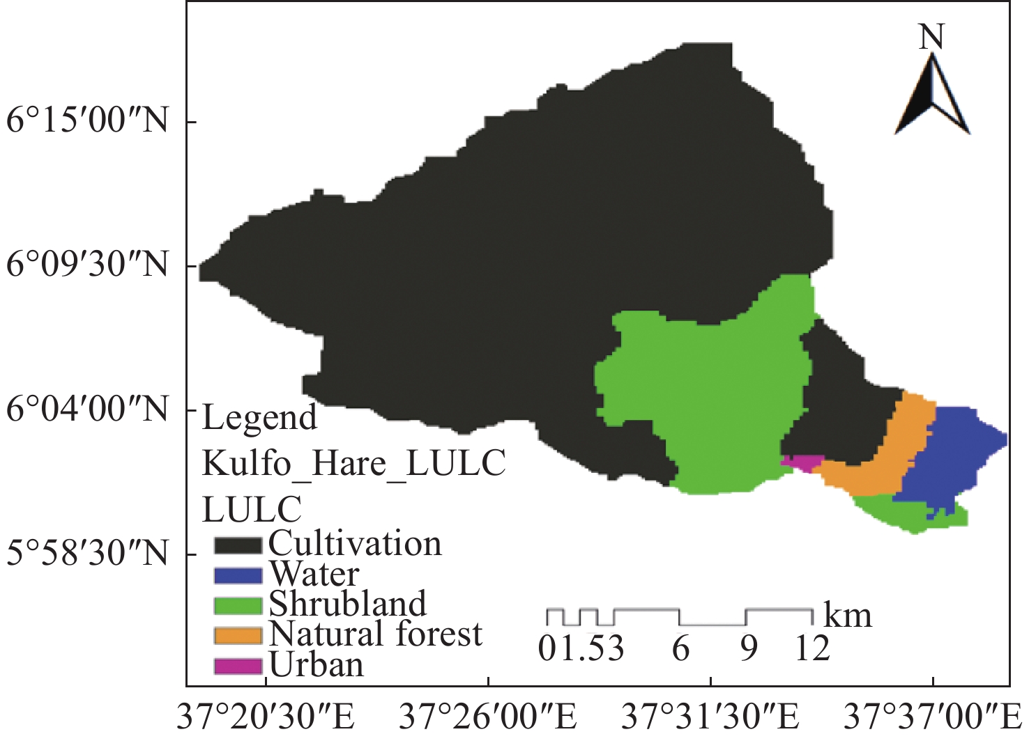
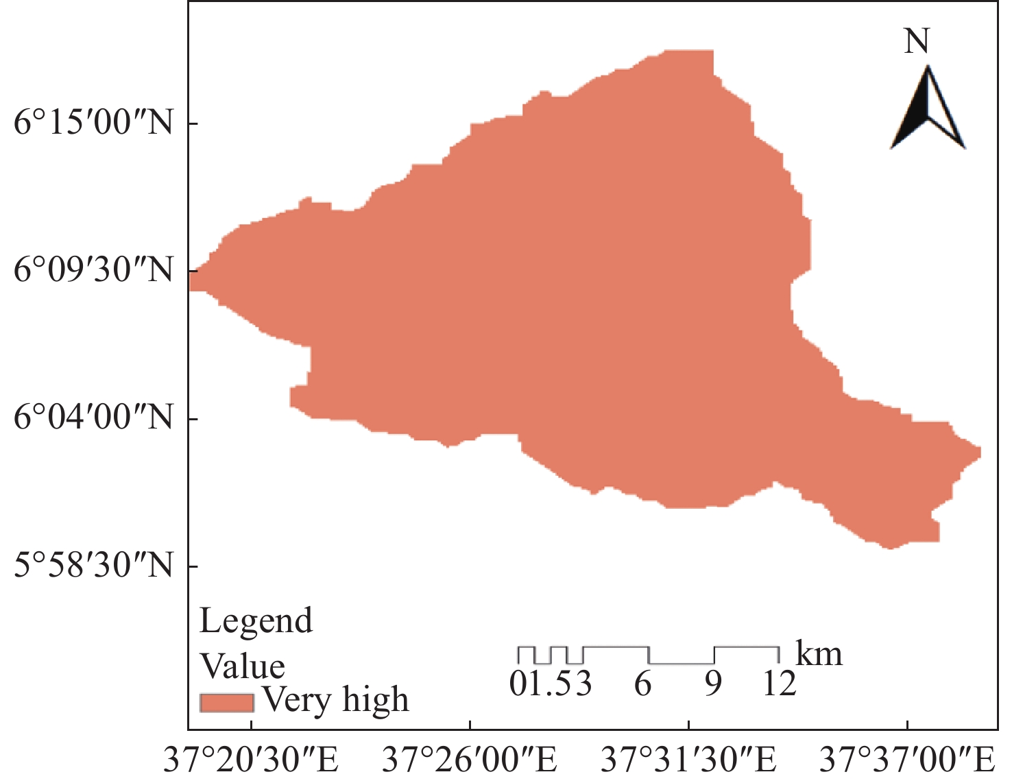
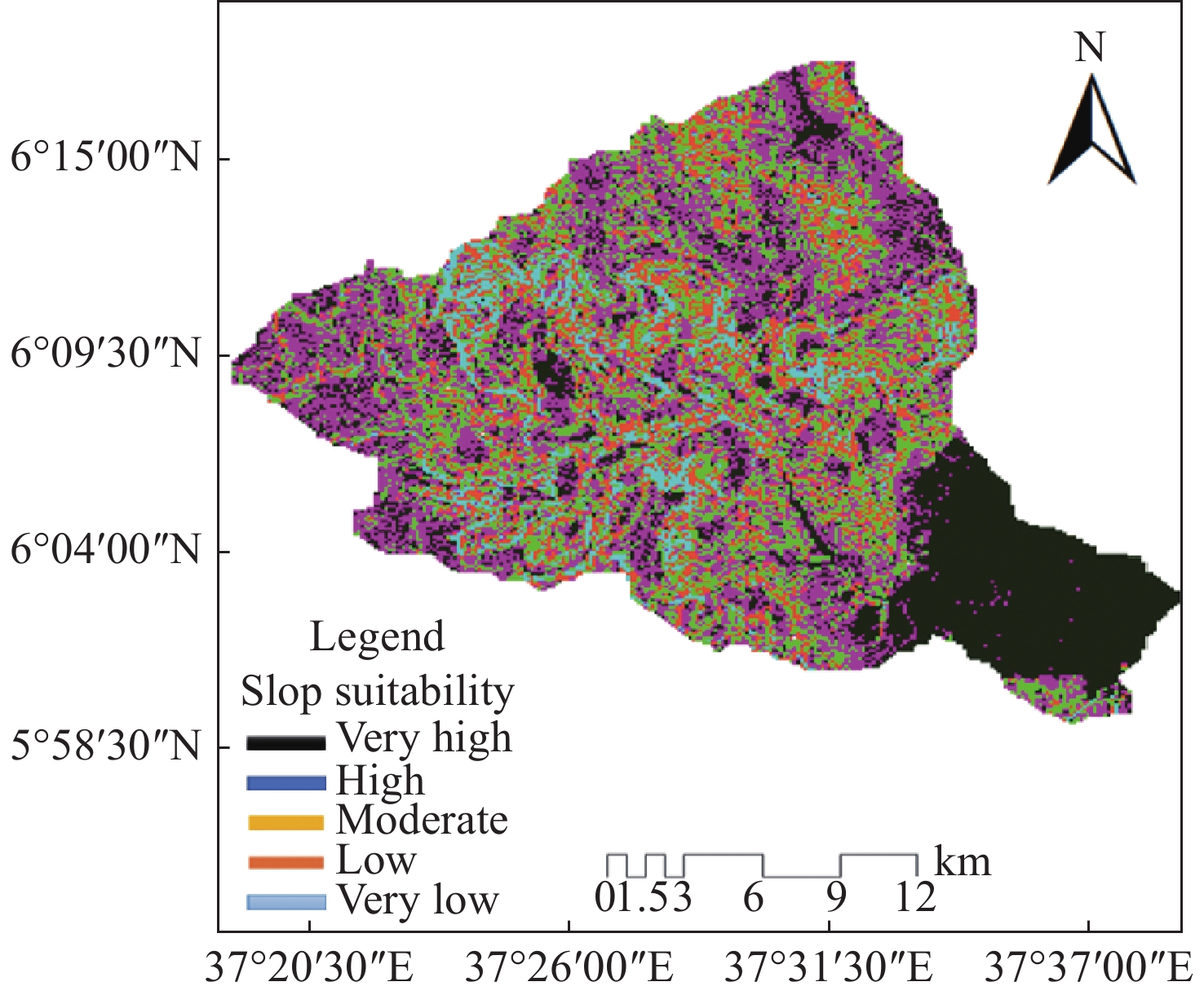
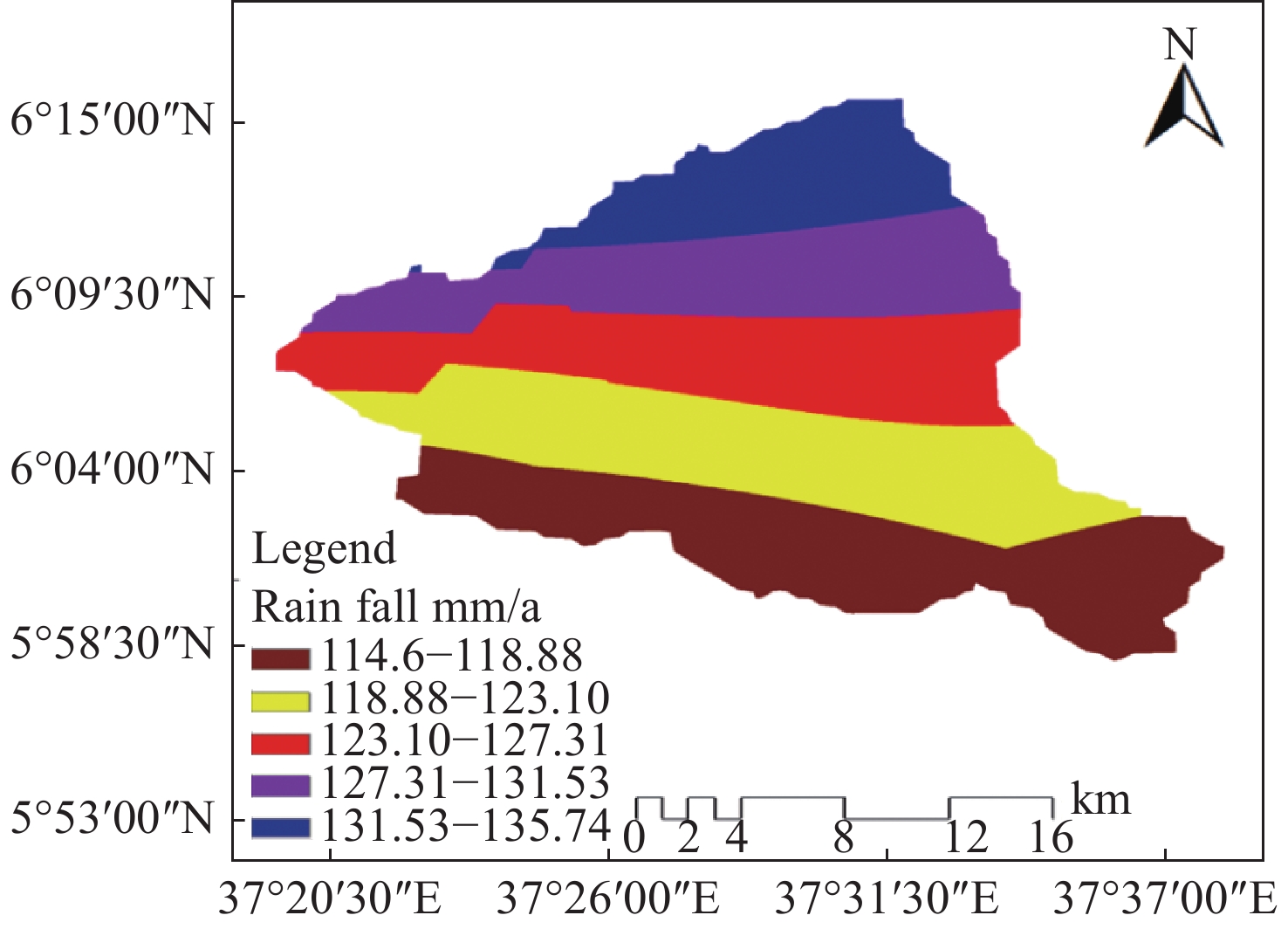
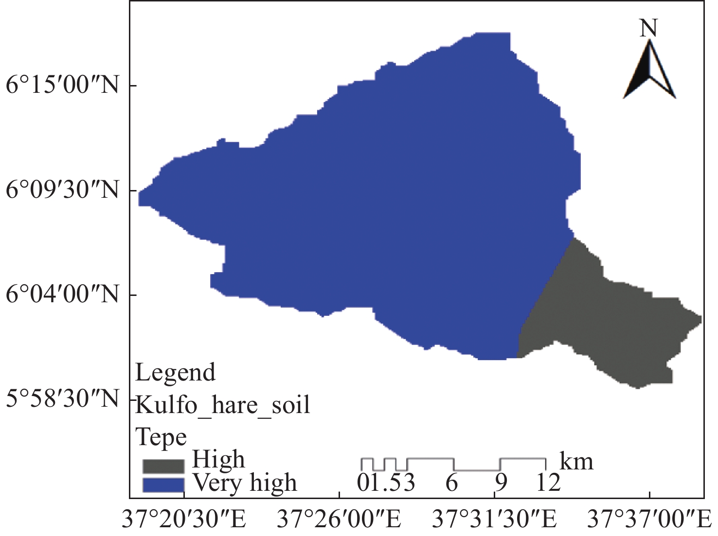
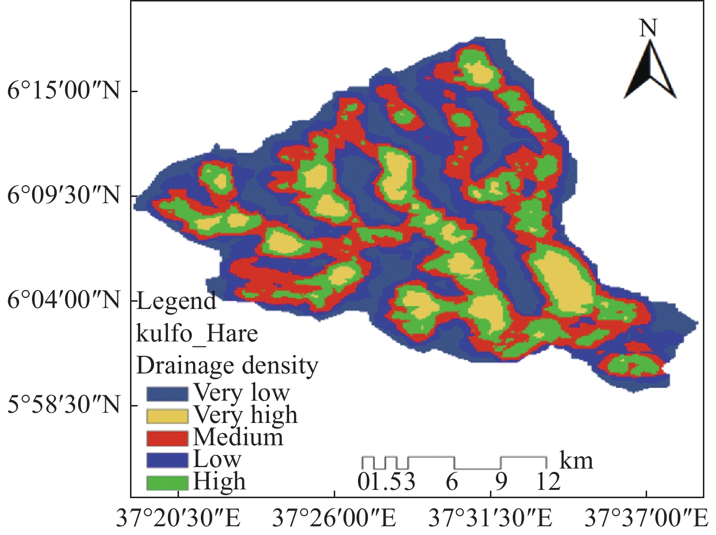
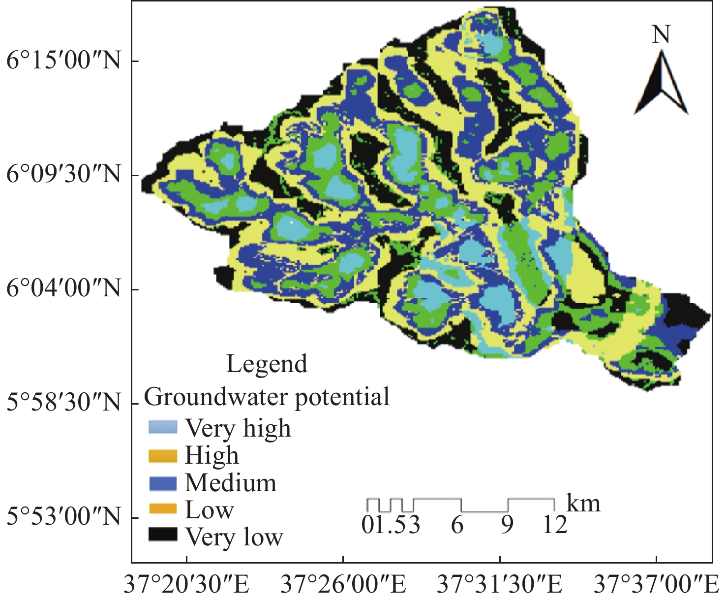
Identification of groundwater potential areas (GPA) is important in regions facing surface water scarcity, as it assists in effective planning and utilization of groundwater for various purposes. This study employs the methods of remote sensing (RS), geographic information system (GIS) model, and analytical hierarchy process (AHP), multi-criteria decision analysis (MCDA) to locate and map the prospective groundwater areas in the Kulfo-Hare watershed. Seven significant groundwater influencing factors were selected for the determination of groundwater potential in the area: Geology, land use/land cover (LULC), soil, rainfall, slope, drainage density, and lineament density. By applying a five-class classification scheme (very low, low, moderate, high, and very high), the GIS models were used to define the distribution of groundwater potential areas in terms of area coverage (km2), percentage and mapping. The results show that the groundwater potential (GWP) distribution in the research region is as follows: 9.7% (6 035.9 ha) classified as very high GWP, 29.6% (18 606 ha) classified as high, 24.5% (15 245 ha) classified as moderate, 18.1% (11 431 ha) as low and 18.1% (11 492 ha) very low GWP, on the basis of the weighted overlay evaluation. Although a few regions are identifies as extremely low GWP, most of the study area is characterized by very high to moderate GWP. These findings provide valuable insight for sustainable groundwater planning by the government bodies, decision-makers, and private sectors.
Assessing the impact of artificial recharge on groundwater in an over-exploited aquifer: A case study in the Cheria Basin, North-East of Algeria
Mouna Djellali, Omar Guefaïfia, Chemsedinne Fehdi, Adel Djellali, Amor Hamad
2023, 11(3): 263-277. doi: 10.26599/JGSE.2023.9280022
Abstract(249) FullText HTML (128) PDF(46)
Abstract:
The Cheria region in Northeastern Algeria has been facing aquifer overexploitation by the agricultural sector and prolonged droughts, resulting in a considerable decline in groundwater levels. This study investigates the feasibility of implementing artificial recharge techniques to replenish the Eocene aquifer which serves as the primary water source in the Cheria region. A 3D transient numerical model, based on the finite difference method, was used to simulate groundwater flow from 2021 to 2031 using Visual MODFLOW Flex. During the modelling process, three scenarios were considered: (1) including pumping without a recharge, (2) recharge of the entire area through efficient infiltration without pumping, and (3) artificial recharge using river water infiltration basins at two sites, Draa Douamis sinkholes and Eocene limestone outcrops. The simulation results showed that aquifer exploitation without recharge caused significant drawdowns, which were 3 m to 7 m in the north-eastern part and 8 m to 12 m in the central and southern parts. In contrast, the second scenario, involving recharge without pumping, showed a rise in groundwater levels of 2 m to 2.7 m in the north-eastern part and 3 m to 3.62 m in the central and southern parts. The third scenario, employing artificial recharge, indicated a positive response to artificial recharge, with increased piezometric levels at the proposed sites, signifying a beneficial impact on the aquifer. These findings underline the potential of artificial recharge as a promising approach to address the groundwater depletion and environmental issues in the Cheria Basin.
Effective groundwater level recovery from mining reduction: Case study of Baoding and Shijiazhuang Plain area
Tian Nan, Chen Yue, Wen-geng Cao, En-lin Mu, Yang Ou, Zhen-sheng Lin, Wei Kang
2023, 11(3): 278-293. doi: 10.26599/JGSE.2023.9280023
Abstract(179) FullText HTML (94) PDF(28)
Abstract:
The effective recovery of water level is a crucial measure of the success of comprehensive groundwater over-exploitation management actions in North China. However, traditional evaluation method do not directly capture the relationship between mining and other equilibrium elements. This study presents an innovative evaluation method to assess the water level recovery resulting from mining reduction based on the relationship between variation in exploitation and recharge. Firstly, the recharge variability of source and sink terms for both the base year and evaluation year is calculated and the coefficient of recharge variation β is introduced, which is then used to calculate the effective mining reduction and solve the water level recovery value caused by the effective mining reduction, and finally the water level recovery contribution by mining reduction is calculated by combining with the actual volume of mining reduction in the evaluation area. This research focuses on Baoding and Shijiazhuang Plain area, which share similar hydrogeological conditions but vary in groundwater exploitation and utilization. As the effect of groundwater level recovery with mining reduction was evaluated in these two areas as case study. In 2018, the results showed an effective water level recovery of 0.17 m and 0.13 m in the shallow groundwater of Shijiazhuang and Baoding Plain areas, respectively. The contributions of recovery from mining reduction were 76% and 57.98% for these two areas, respectively. It was notable that the water level recovery was most prominent in the foothill plain regions. From the evaluation results, it is evident that water level recovery depends not only on the intensity of groundwater mining reduction, but also on its effectiveness. The value of water level recovery alone cannot accurately indicate the intensity of mining reduction, as recharge variation significantly influences water level changes. Therefore, in practice, it is crucial to comprehensively assess the impact of mining reduction on water level recovery by combining the coefficient of recharge variation with the contribution of water level recovery from mining reduction. This integrated approach provide a more reasonable and scientifically supported basis, offering essential data support for groundwater management and conservation. To improve the accuracy and reliability of evaluation results, future work will focus on the standardizing and normalizing raw data processing.
Effectiveness of groundwater extraction in Beijing since the ingauration of the first phase of the South-to-North Water Diversion Project, China
Yuan-yuan Gao, Qing-yu Sun, Ai-xin Wen, Yan-pei Cheng
2023, 11(3): 294-307. doi: 10.26599/JGSE.2023.9280024
Abstract(156) FullText HTML (79) PDF(33)
Abstract:
This study assess the effectiveness of groundwater pressure extraction in Beijing since the opening of the first phase of the South-to-North Water Diversion Project, using survey and evaluation methods. Firstly, an analysis of water consumption structure and the usage of diverted river water in Beijing in recent years was conducted. Secondly, the volume of groundwater pressure extraction in Beijing after the project's inauguration was examined, revealing a decrease from 1.96 billion m3 in 2014 to 1.35 billion m3 in 2020. The proportion of water supply reduced from 52.3% in 2014 to 33.3% in 2020, leading to an optimized water supply structure. By the end of 2020, groundwater pressure extraction in Beijing is estimated at 446 million m3, with a substantial reduction in over-exploitation of groundwater. Groundwater resources have been effectively replenished, and the strategic reserve capacity has been enhanced. Furthermore, this study evaluates the change in groundwater levels as an indicator of the effectiveness of pressure extraction. The declining trend of groundwater levels in Beijing has been effectively mitigated, and there has been a consistent rebound in groundwater levels over the past five years.
Development and application of multi-field coupled high-pressure triaxial apparatus for soil
Xiu-yan Wang, Lin Sun, Shuai-wei Wang, Ming-yu Wang, Jin-qiu Li, Wei-chao Sun, Jing-jing Wang, Xi Zhu, He Di
2023, 11(3): 308-316. doi: 10.26599/JGSE.2023.9280025
Abstract(210) FullText HTML (109) PDF(19)
Abstract:
The increasing severity of ground subsidence, ground fissure and other disasters caused by the excessive exploitation of deep underground resources has highlighted the pressing need for effective management. A significant contributing factor to the challenges faced is the inadequacy of existing soil mechanics experimental instruments in providing effective indicators, creating a bottleneck in comprehensively understanding the mechanisms of land subsidence. It is urgent to develop a multi-field and multi-functional soil mechanics experimental system to address this issue. Based soil mechanics theories, the existing manufacturing capabilities of triaxial apparatus and the practical demands of the test system, a set of multi-field coupled high-pressure triaxial system is developed tailored for testing deep soils (at depths of approximately 3 000 m) and soft rock. This system incorporates specialized design elements such as high-pressure chamber and horizontal deformation testing devices. In addition to the conventional triaxial tester functions, its distinctive feature encompass a horizontal deformation tracking measuring device, a water release testing device and temperature control device for the sample. This ensemble facilitates testing of horizontal and vertical deformation water release and other parameters of samples under a specified stress conditions, at constant or varying temperature ranging from −40°C–90°C. The accuracy of the tested parameters meets the requirements of relevant current specifications. The test system not only provides scientifically robust data for revealing the deformation and failure mechanism of soil subjected to extreme temperature, but also offers critical data support for major engineering projects, deep exploration and mitigation efforts related to soil deformation-induced disaster.

Welcome to Journal of Groundwater Science and  Engineering!

Quick Submit

Online Submission   E-mail Submission