 E-mail alert
 Rss
Rss

Extenuating the parameters using HEC-HMS hydrological model for ungauged catchment in the central Omo-Gibe Basin of Ethiopia
-
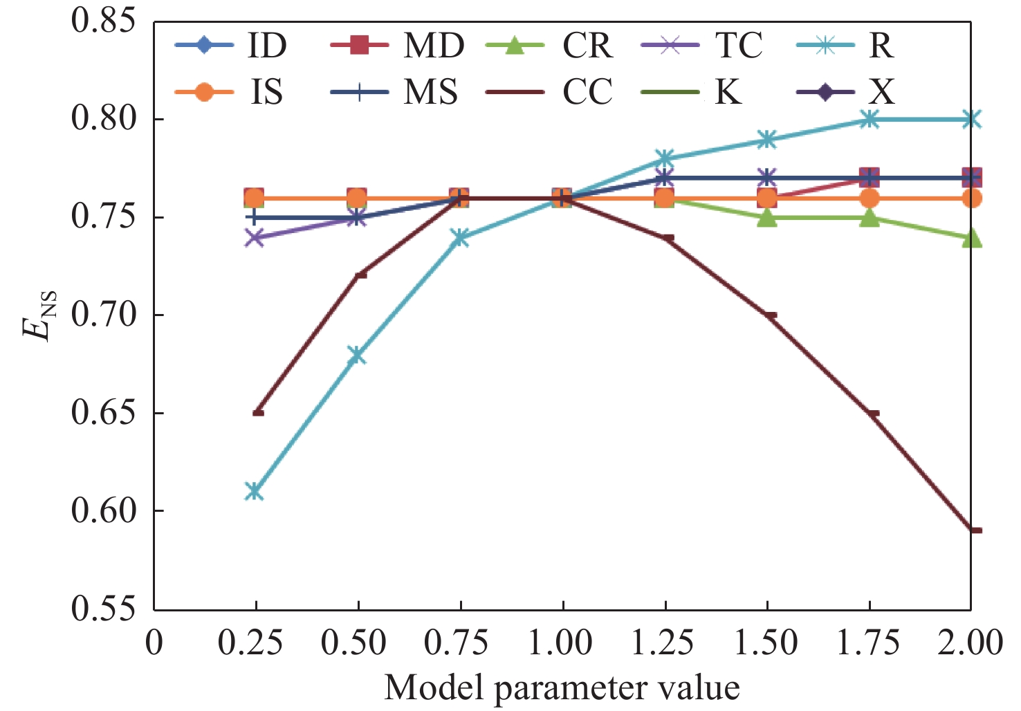
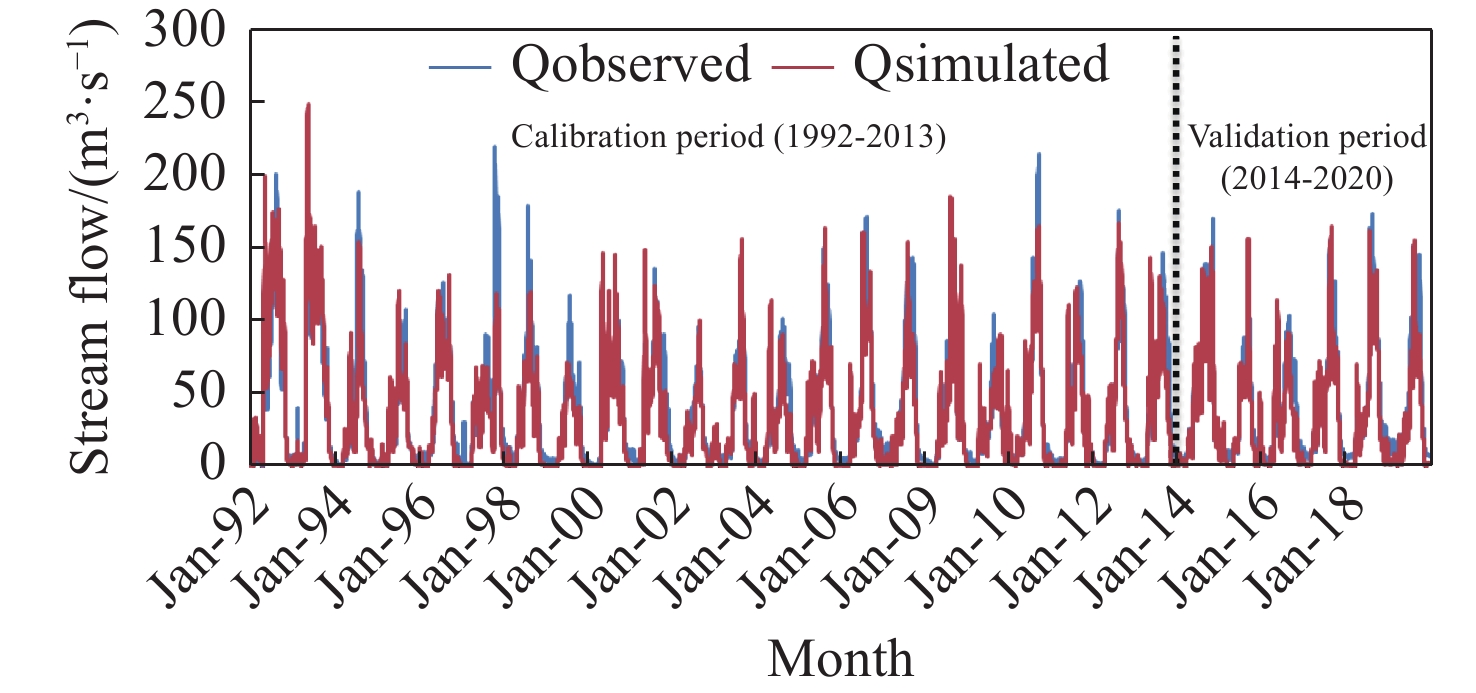
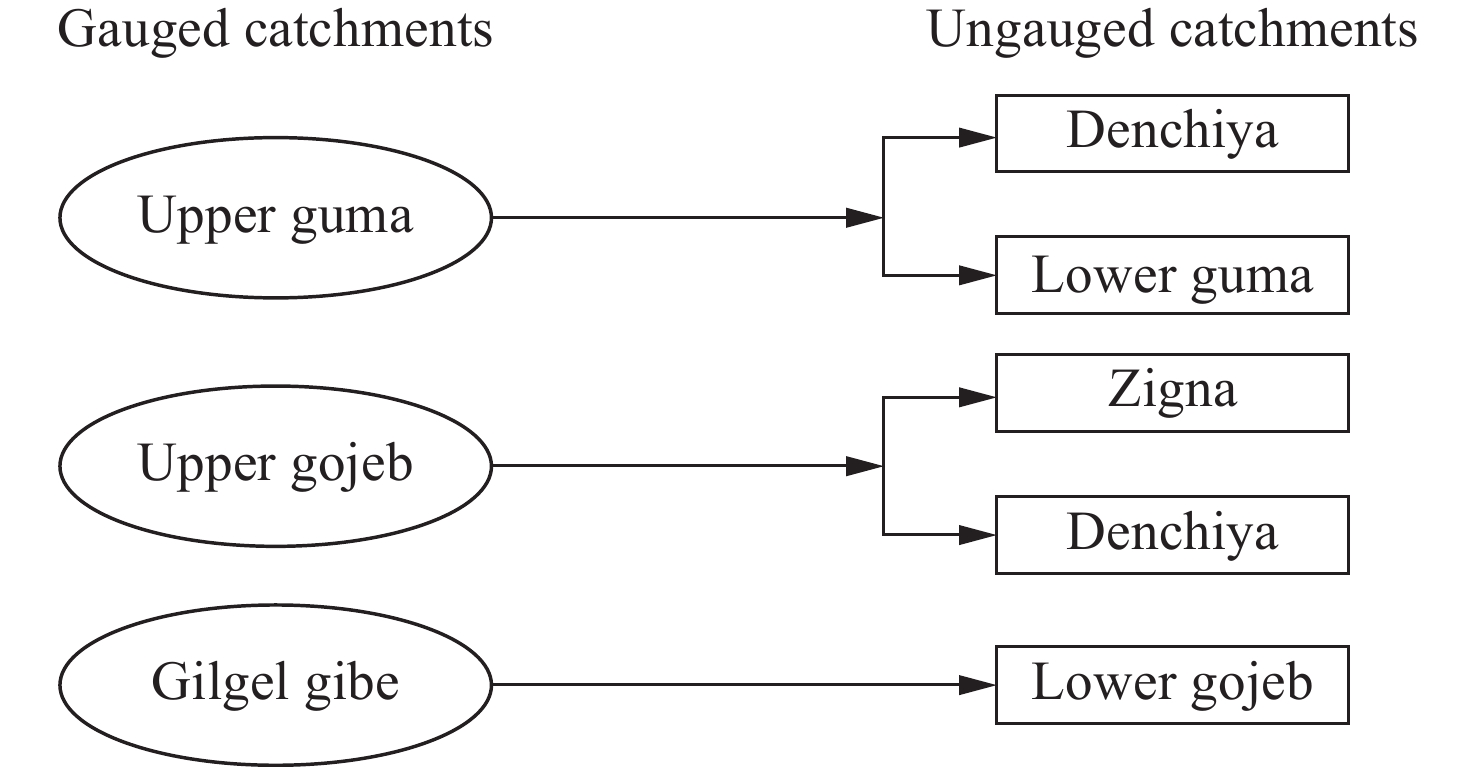
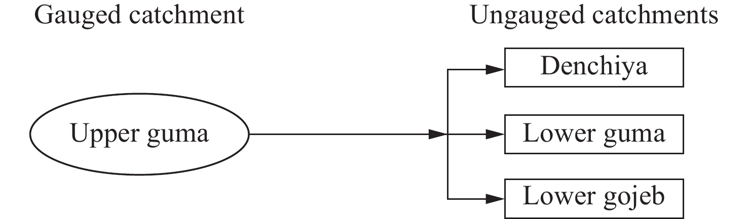
Abstract: Characteristics of ungauged catchments can be studied from the hydrological model parameters of gauged catchments. In this research, discharge prediction was carried out in ungauged catchments using HEC-HMS in the central Omo-Gibe basin. Linear regression, spatial proximity, area ratio, and sub-basin mean were amalgamated for regionalization. The regional model parameters of the gauged catchment and physical characteristics of ungauged catchments were collated together to develop the equations to predict discharge from ungauged catchments. From the sensitivity analysis, crop coefficient (CC), storage coefficient (R), constant rate (CR), and time of concentration (TC) are found to be more sensitive than others. The model efficiency was evaluated using Nash–Sutcliffe Efficiency (NSE) which was greater than 0.75, varying between −10% and +10% and the coefficient of determination (R2) was approximated to be 0.8 during the calibration and validation period. The model parameters in ungauged catchments were determined using the regional model (linear regression), sub-basin mean, area ratio, and spatial proximity methods, and the discharge was simulated using the HEC-HMS model. Linear regression was used in the prediction where p-value ≤ 0.1, determination coefficient (R2) = 0.91 for crop coefficient (CC) and 0.99 for maximum deficit (MD). Constant rate (CR), maximum storage (MS), initial storage (IS), storage coefficient (R), and time of concentration (TC) were obtained. The result is that an average of 30 m3/s and 15 m3/s as the maximum monthly simulated flow for ungauged sub-catchments, i.e. Denchiya and Mansa of the main river basin .
-
Key words:
- HEC-HMS /
- Regionalization /
- Stream flow simulation /
- Ungauged catchments /
- Omo-Gibe sub-basin
-
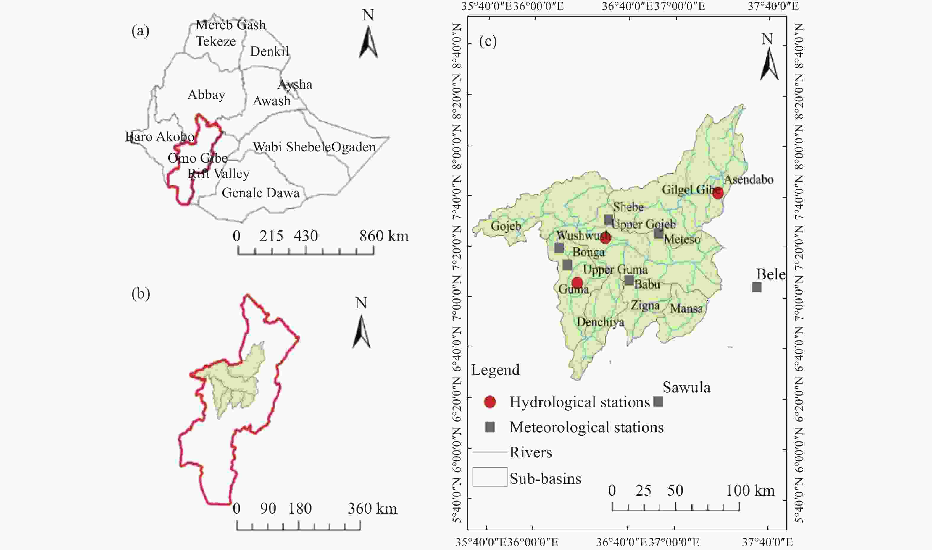
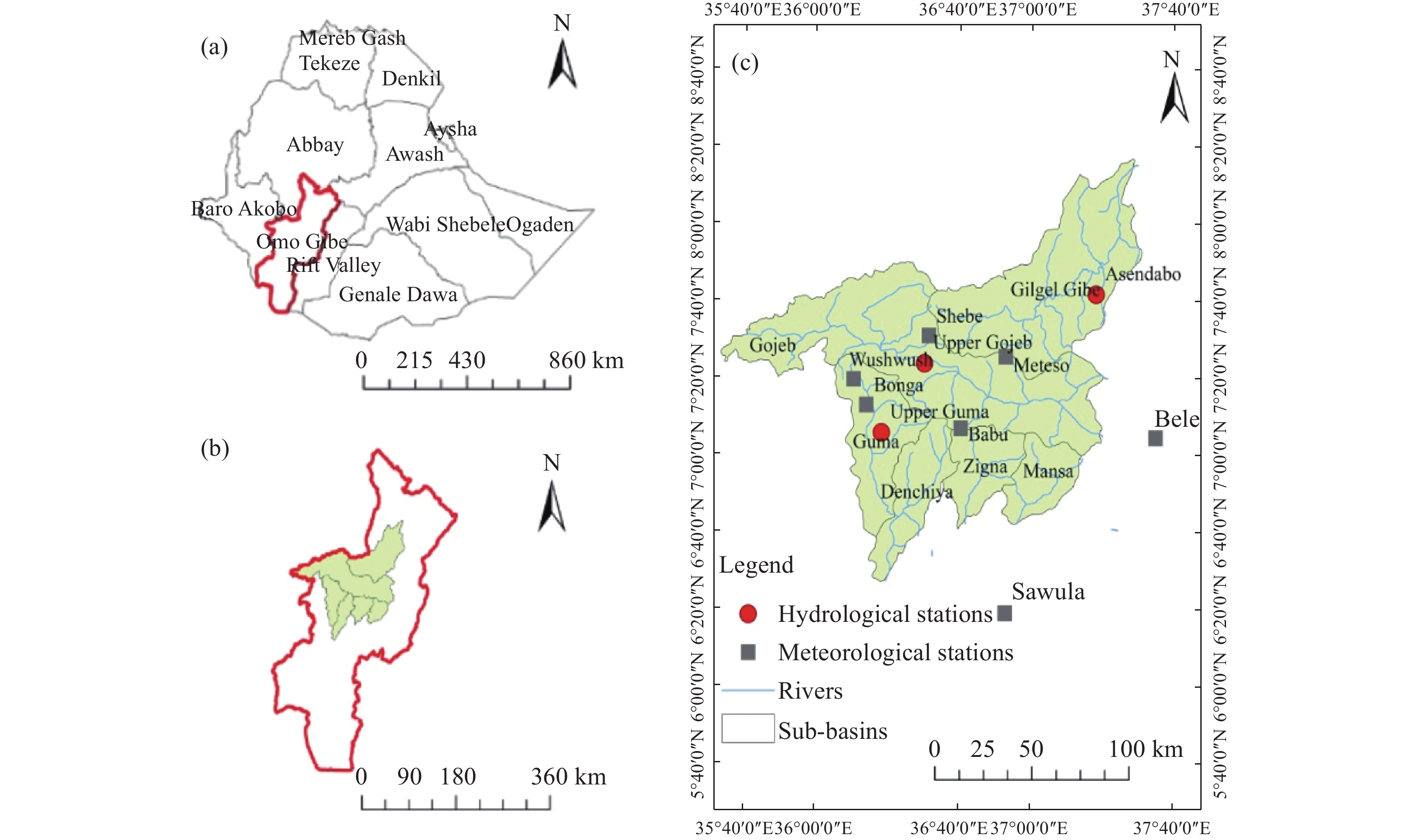
Figure 1. Study Area a) Major river basins in Ethiopia, b) Omo-Gibe River Basin and selected sub-watersheds c) Selected sub-watersheds and rivers
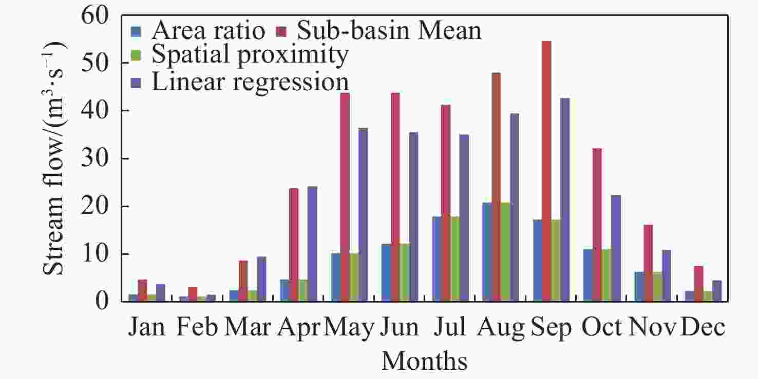
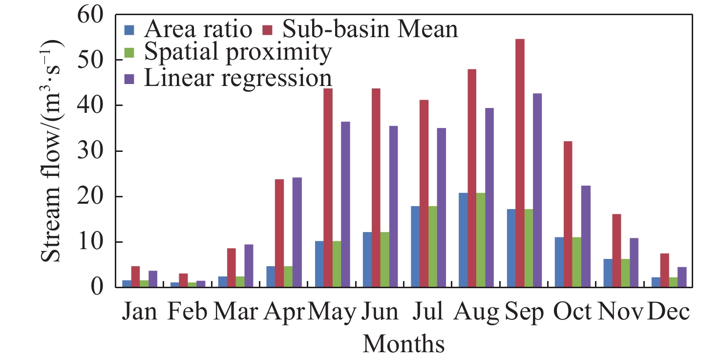
Figure 6. Comparsion of average monthly simulated flow for selected sub-catchment of Lower Guma by using four regionalization method
Table 1. Summary of hydrologically gauged stations
No River Station/site Area (km2) Latitude/Degree Longitude/Degree 1 Upper Gojeb Near Shebe 3577 7.4 36.5 2 Gilgel Gibe Near Asendabo 2966 7.7 37.3 3 Upper Guma Near Andra 231.2 7.1 36.3  下载: 导出CSV
Table 2. Model parameters estimated for ungauged catchments using regional model
Ungauged catchments TC R IS MS ID MD CR K X CC Mansa 27 25 17 11 0.47 2.7 0.42 1.6 0.18 0.58 Zigna 25 26 18 11 0.39 2.6 0.24 0.6 0.18 0.67 Denchiya 26 26 18 11 0.46 2.6 0.25 0.6 0.18 0.82 Lower Guma 30 26 18 11 0.39 2.6 0.17 0.5 0.19 0.83 Lower Gojeb 52 29 23 9 0.47 2.8 0.35 1.6 0.23 0.84
下载: 导出CSV
Table 3. Geographic and physiographic catchment characteristics correlation (R2) and Land Cover catchment characteristics correlation (R2)
Ungauged
CatchmentsGeographic and physiographic catchment characteristics correlation (R2) Land Cover catchment characteristics correlation (R2) Gauged catchments Gauged catchments Upper Guma Upper Gojeb Gilgel Gibe Upper Guma Upper Gojeb Gilgel Gibe Mansa 0.92 0.82 0.83 0.52 0.06 0.62 Zigna 0.90 0.85 0.85 0.03 0.06 0.03 Denchiya 0.87 0.84 0.83 0.01 0.08 0.01 Lower Guma 0.90 0.84 0.84 0.77 0.05 0.88 Lower Gojeb 0.56 0.96 0.92 0.58 0.08 0.67
下载: 导出CSV
Table 4. Correlation of Soil catchment characteristics (R2) and Climate catchment characteristics (R2)
Ungauged
CatchmentsCorrelation of Soil catchment characteristics (R2) Climate catchment characteristics (R2) Gauged catchments Gauged catchments Upper Guma Upper Gojeb Gilgel Gibe Upper Guma Upper Gojeb Gilgel Gibe Mansa 0.35 0.37 0.11 1 1 1 Zigna 0.92 0.98 0.42 1 1 1 Denchiya 0.48 0.53 0.14 1 1 1 Lower Guma 0.93 0.98 0.41 1 1 1 Lower Gojeb 0.45 0.48 0.15 1 1 1
下载: 导出CSV
Table 5. Correlation values between model parameters (MPs) and physical catchment characteristics (PCCs) for gauged catchments
PCCs TC R IS MS ID MD CR K X CC Avarge slope −0.64 −0.76 −0.44 −0.44 −0.98 −0.83 −0.99 −0.02 −0.77 −0.24 Longest flow path −0.64 −0.51 0.96 −0.96 −0.04 0.69 0.34 0.99 −0.50 −0.91 Mean elevation 0.99 0.97 −0.50 0.50 0.72 0.00 0.41 −0.82 0.96 0.94 Minimum elevation 0.89 0.95 0.05 −0.05 0.98 0.55 0.84 −0.38 0.96 0.60 Maximum elevation 0.57 0.44 −0.98 0.98 −0.04 −0.75 −0.42 −0.97 0.43 0.88 Sum stream length −0.40 −0.25 1.00 −1.00 0.4 0.87 0.59 0.90 −0.24 −0.76 Area −0.43 −0.29 1.00 −1.00 0.21 0.85 0.56 0.92 −0.27 −0.79 Perimeter −0.21 −0.06 0.98 −0.98 0.43 0.95 0.74 0.80 −0.04 −0.62 HI − − − − − − − − − − DD 0.44 0.29 −1.00 1.00 −0.20 −0.84 0.55 −0.92 0.28 0.79 CI 0.73 0.61 −0.92 0.92 0.16 −0.60 −0.23 −1.00 0.60 0.96 EL −0.99 −1.00 0.26 −0.26 −0.87 −0.26 −0.63 0.65 −1.00 −0.82 Basin shape 0.30 0.15 −0.99 0.99 −0.34 −0.91 −0.67 −0.85 0.13 0.69 Dystric nitosols −0.70 −0.80 −0.37 0.37 −0.99 −0.79 −0.97 0.06 −0.81 −0.31 Dystric fluvisols 1.00 1.00 −0.32 0.32 0.84 0.20 0.58 −0.69 1.00 0.86 Orthic acrisols 0.32 0.47 0.74 −0.74 0.83 0.98 0.98 0.38 0.48 −0.13 Dystric gleysols 0.09 −0.07 −0.95 0.95 −0.54 −0.98 −0.81 −0.71 −0.08 0.52 Leptosols −0.99 −0.96 0.50 0.50 −0.72 0.00 −0.41 −0.41 −0.96 −0.94 Cambisols −0.99 −0.96 0.50 −0.50 −0.72 0.00 −0.41 −0.41 −0.96 −0.94 Chromic vertisols 0.58 0.70 0.51 −0.51 0.96 0.87 1.00 0.10 0.71 0.16 Eutric cambisol −0.99 −0.96 0.50 −0.50 −0.72 0.00 −0.41 −0.41 −0.96 −0.94 Eutric nitosols −0.16 0.00 0.97 −0.97 0.48 0.96 0.77 0.77 0.01 −0.58 Orthic solonchaks −0.99 −0.96 0.50 −0.50 −0.72 0.00 −0.41 0.82 −0.96 −0.94 Gypsic yermosola −0.99 −0.96 0.50 −0.50 −0.72 0.00 −0.41 0.82 −0.96 −0.94 Eutric fluvisols 0.59 0.71 0.50 −0.50 0.96 0.87 0.99 0.08 0.72 0.18 Cultivation 0.99 1.00 −0.29 0.29 0.86 0.23 0.60 −0.67 1.00 0.84 Natural forest −0.98 −1.00 0.22 −0.22 −0.90 −0.30 −0.66 0.61 −1.00 −0.71 Shurb land − − − − − − − − − − Grass land −0.79 −0.68 0.88 −0.88 −0.24 0.53 0.14 1.00 −0.67 −0.98 Wood land − − − − − − − − − − SAAR −0.18 −0.33 −0.83 0.83 −0.74 −1.00 −0.94 −0.51 −0.34 0.28 MP dry −0.44 −0.57 −0.65 0.65 −0.90 −0.94 −1.00 −0.26 −0.59 0.00 MP wet −0.20 −0.35 −0.82 0.82 −0.76 −1.00 −0.95 −0.49 −0.36 0.25 PET 0.38 0.23 −1.00 1.00 −0.27 −0.88 −0.61 −0.89 0.21 0.75 Note: CI-Circularity index, DD-Drainage density, EL-Elongation Ratio, HI-Hypsometric integral, PET-Potential Evapo-transpiration, SAAR-Standard Annual Average Rainfall.
下载: 导出CSV
-
Abebe NA, Ogden FL, Pradhan, NR. 2010. Sensitivity and uncertainty analysis of the conceptual HBV rainfall–runoff model: Implications for parameter estimation. Journal of Hydrology, 389: 301-310. doi: 10.1016/j.jhydrol.2010.06.007 Arsenault R, Breton-Dufour M, Poulin A, et al. 2019. Streamflow prediction in ungauged basins: analysis of regionalization methods in a hydrologically heterogeneous region of Mexico. Hydrological Sciences Journal, 64(11): 1297-1311. doi: 10.1080/02626667.2019.1639716 Bao Z, Zhang J, Liu J, et al. 2012. Comparison of regionalization approaches based on regression and similarity for predictions in Ungauged catchments under multiple hydro-climatic conditions. Journal of Hydrology, 466-467: 37-46 Barbarossa V, Huijbregts MAJ, Hendriks AJ, et al. 2017. Developing and testing a global-scale regression model to quantify mean annual stream-flow. Journal of Hydrology, 544: 479-487. doi: 10.1016/j.jhydrol.2016.11.053 Blöschl, G. 2005. Rainfall runoff modeling of ungauged catchments In M. L. Anderson, ed. Encyclopedia of hydrological sciences UK: John Wiley & Sons: 2061– 2080. Donnelly C, Andersson JCM, Arheimer B. 2016. Using flow signatures and catchment similarities to evaluate the E-HYPE multi-basin model across Europe. Hydrological Sciences Journal, 61(2): 255-273. doi: 10.1080/02626667.2015.1027710 Goswami M, Connor KM, Bhattarai KP, et al. 2005. Assessing the performance of eight real-time updating models and procedure for the Brosna River. Hydrology and the Earth System Sciences, 9(4): 394-411. doi: 10.5194/hess-9-394-2005 Hailegeorgis TT, Abdella YS, Alfredsen, K, et al. 2015. Evaluation of regionalization methods for hourly continuous streamflow simulation using distributed models in Boreal Catchments. Journal of Hydrologic Engineering, 1-20: 04015028. doi: 10.1061/(ASCE)HE.1943-5584.0001218 Ibrahim B, Wisser D, Barry B, et al. 2015. Hydrological predictions for small ungauged watersheds in the Sudanian zone of the Volta basin in West Africa. Journal of Hydrology: Regional Studies, 4: 386-397. doi: 10.1016/j.ejrh.2015.07.007 IHMS. 2006. Integrated Hydrological Modeling System Manual. Version 5.1. Javeed Y, Apoorva KV. 2015. Flow regionalization under limited data availability application of IHACRES in the Western Ghats. Aquatic Proceeding 4: (LCWRCOE) 2015: 933-941. Li H, Zhang Y, Zhou X. 2015. Predicting surface runoff from Catchment to Large Region. Advances in Meteorology: 1-13. doi: 10.1155/2015/720967 Mazvimavi D. 2003. Estimation of flow characteristics of ungauged catchments: Case study in Zimbabwe. Wageningen Universiteit: 1-176. Merz R, Bloschl G. 2004. Regionalization of catchment model parameters. Journal of Hydrology, 287(1-4): 95-123. doi: 10.1016/j.jhydrol.2003.09.028 Mosavi A, Golshan M, Choubin B. 2021. Fuzzy clustering and distributed model for streamflow estimation in ungauged watersheds. Scientific Reports, 11: 8243. doi: 10.1038/s41598-021-87691-0 Nega H, Seleshi Y. 2021. Regionalization of mean annual flow for ungauged catchments in case of Abbay River Basin, Ethiopia. Modeling Earth Systems and Environment, 7: 341-350. doi: 10.1007/s40808-020-01033-z Oudin L, Andre´assian V, Perrin C, et al. 2008. Spatial proximity, physical similarity, regression and Ungauged catchments: A comparison of regionalization approaches based on 913 French catchments. Water Resources Research, 44: W03413. doi: 10.1029/2007WR006240 Pinheiro VB, Naghettini M. 2013. Calibration of the parameters of a rainfall-runoff model in Ungauged basins using synthetic flow duration curves as estimated by regional analysis. Journal of Hydrologic Engineering, 18: 1617-1626. doi: 10.1061/(ASCE)HE.1943-5584.0000737 Pool S, Viviroli D, Seibert J. 2017. Prediction of hydrographs and flow-duration curves in almost ungauged catchments: Which runoff measurements are most informative for model calibration? Journal of Hydrology, 554: 613-622. Rajendran M, Gunawarden ERN, Dayawansa NDK. 2020. Runoff prediction in an ungauged catchment of Upper Deduru Oya Basin, Sri Lanka: A comparison of HEC-HMS and WEAP models. International Journal of Progressive Sciences and Technologies (IJPSAT), 18(2): 121-129. Roy S, Mistri B. 2013. Estimation of peak flood discharge for an Ungauged River: A case study of the Kunur River, West Bengal, Geography Journal, 214140: 11. Samuel J, Coulibaly P, Metcalfe RA. 2011. Metcalfe estimation of continuous stream flow in ontario ungauged basins: Comparison of regionalization methods. Journal of Hydrologic Engineering, 16(5): 447-459. doi: 10.1061/(ASCE)HE.1943-5584.0000338 Sawicz K, Wagener Sivapalan TM, Troch PA, et al. 2011. Catchment classification: Empirical analysis of hydrologic similarity based on catchment function in the eastern USA. Hydrology Earth Systems Sciences, 15(9): 2895-2911. doi: 10.5194/hess-15-2895-2011 Sellami H, Jeunesse IL, Benabdallah S, et al. 2014. Uncertainty analysis in model parameters regionalization: A case study involving the SWAT model in Mediterranean catchments (Southern France). Hydrology and Earth System Sciences, 18: 2393-2413. doi: 10.5194/hess-18-2393-2014 Shoaib SA, Bardossy A, Wagener T, et al. 2013. A different light in predicting Ungauged Basins: Regionalization approach based on Eastern USA Catchments. Journal of Civil Engineering and Architecture, 7 (3) (64): 364-378. Sivapalan M, Takeuchi K, Franks SW, et al. 2003. IAHS decade on predictions in ungauged basins (PUB), 2003-2012: Shaping an exciting future for the hydrological sciences. Hydrologocal Sciences Journal, 48(6): 857-880. doi: 10.1623/hysj.48.6.857.51421 Solomon SM. 2001. Climate change 2007-The physical science basis: Working group1 contribution to the fourth assessment report of the IPCC: (vol. 4). Cambridge University Press. Swain JB, Patra KC. 2019. Impact of catchment classification on streamflow regionalization in ungauged catchments. SN Applied Sciences 1: 456. doi: 10.1007/s42452-019-0476-6 Tamalew C, Kemal A. 2016. Estimation of discharge for ungauged catchments using rainfall-runo model in Didessa Subbasin: The case of Blue Nile River. International Journal of Innovations in Engineering Research and Technology, 3(9): 62-72. Tesfalem A, Yan L, Sirak T, et al. 2021. Quantifying the regional water balance of the Ethiopian Rift Valley Lake basin using an uncertainty estimation framework. Hydrology and Earth Science System:1-25. Teutschbein C, Grabs T, Hjalmar L, et al. 2018. Simulating streamflow in ungauged basins under a changing climate: The importance of landscape characteristics. Journal of Hydrology, 561: 160-178. doi: 10.1016/j.jhydrol.2018.03.060 Wagener T, Wheater HS, Gupta HV. 2004. Rainfall-runoff modelling in gauged and ungauged catchments. London, Imperial College Press: 300. Wale A, Rientjes THM, Gieske ASM, et al. 2009. Ungauged catchment contributions to Lake Tana’s water balance. Hydrological Processes, 23(6): 3682-3692. doi: 10.1002/hyp.7284 Zamoum S, Souag-Gamane, D. 2019. Monthly streamflow estimation in ungauged catchments of northern Algeria using regionalization of conceptual model parameters. Arabian Journal of Geosciences, 342: 12 (11). Zhang Y, Chiew FHS. 2009. Relative merits of different methods for runoff predictions in ungauged catchments. Water Resources Research, 45(7). -

 点击查看大图
计量
- 文章访问数: 666
- HTML全文浏览量: 270
- PDF下载量: 67
- 被引次数: 0


