 E-mail alert
 Rss
Rss

Geoelectrical survey over perched aquifers in the northern part of Upper Sakarya River Basin, Türkiye
-
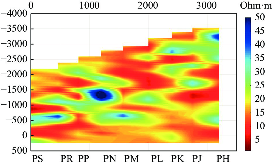
Abstract: In this study, a groundwater exploration survey was conducted using the DC Resistivity (DCR) method in a hydrogeological setting containing a perched aquifer. DCR data were gathered and an electrical tomography section was recovered using conventional four-electrode instruments with a Schlumberger array and a two-dimensional (2D) inversion scheme. The proposed scheme was tested over a synthetic three-dimensional (3D) subsurface model before deploying it in a field situation. The proposed method indicated that gathering data with simple four-electrode instruments at stations along a line and 2D inversion of datasets at multiple stations can recover depth intervals of the studied aquifer in the hydrogeological setting even if it has a 3D structure. In this study, 2D inversion of parallel profiles formed a pseudo-3D volume of the subsurface resistivity structures and mapped out multiple resistive (>25 ohm·m) bodies at shallow (between 50–100 m) and deep sections (>150 m). In general, the proposed method is convenient to encounter geological units that have limited vertical and spatial extensions in any direction and presents resistivity contrast from groundwater-bearing geologic materials.
-
Key words:
- Groundwater /
- Perched Aquifer /
- DC Resistivity /
- Inversion /
- Sakarya River /
- Türkiye
②URL1 2019.https://github.com/fatiando (AD 19.11.2019)
③URL2 2019.https://github.com/gimli-org/gimli (AD 19.11.2019)
注释: -
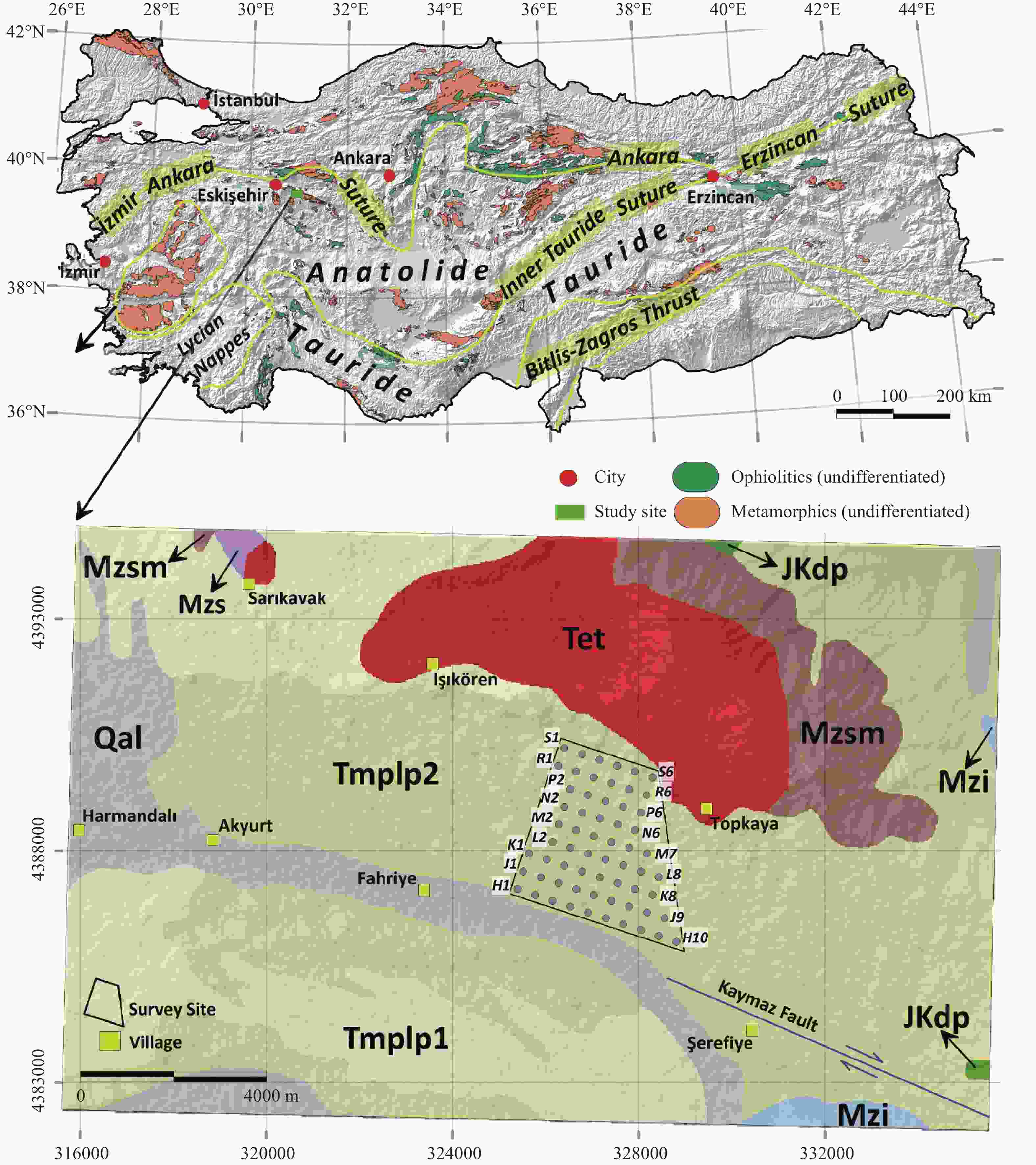
Figure 1. The global location and Tectono-stratigraphic terranes of Anatolia (Türkiye) and the surface geology of the study site and the survey site (the geophysical survey site) with the arrangement of VES stations (gray dots in the survey site) (compiled from MTA (1964), SRTM Elevation Data of 1 arc-second from EARTHDATA (2021) and Zürcher et al. (2010).
Notes: Stratigraphic names of the rocks are as follows: Mzi (İnönü Marbel), Mzs (Sarıkavak formation), Mzsm (Marble member), JKdp (Dağküplü Peridotite), Kdm (Dağküplü mélange), Tmplp1 (Conglomerate-sandstone member), Tmplp2 (Claystone-marn-tuff member), Tet (Topkaya granitoid), Qal (Alluvium). The map was compiled from Akbaş et al. (2011), Emre et al. (2013, 2018), GMVDE (2016) and SRTM Elevation Data of 1 arc-second from EARTHDATA (2021). The figure uses Universal Transverse Mercator projection with WGS 84 datum in 36 Northern Hemisphere Zone.
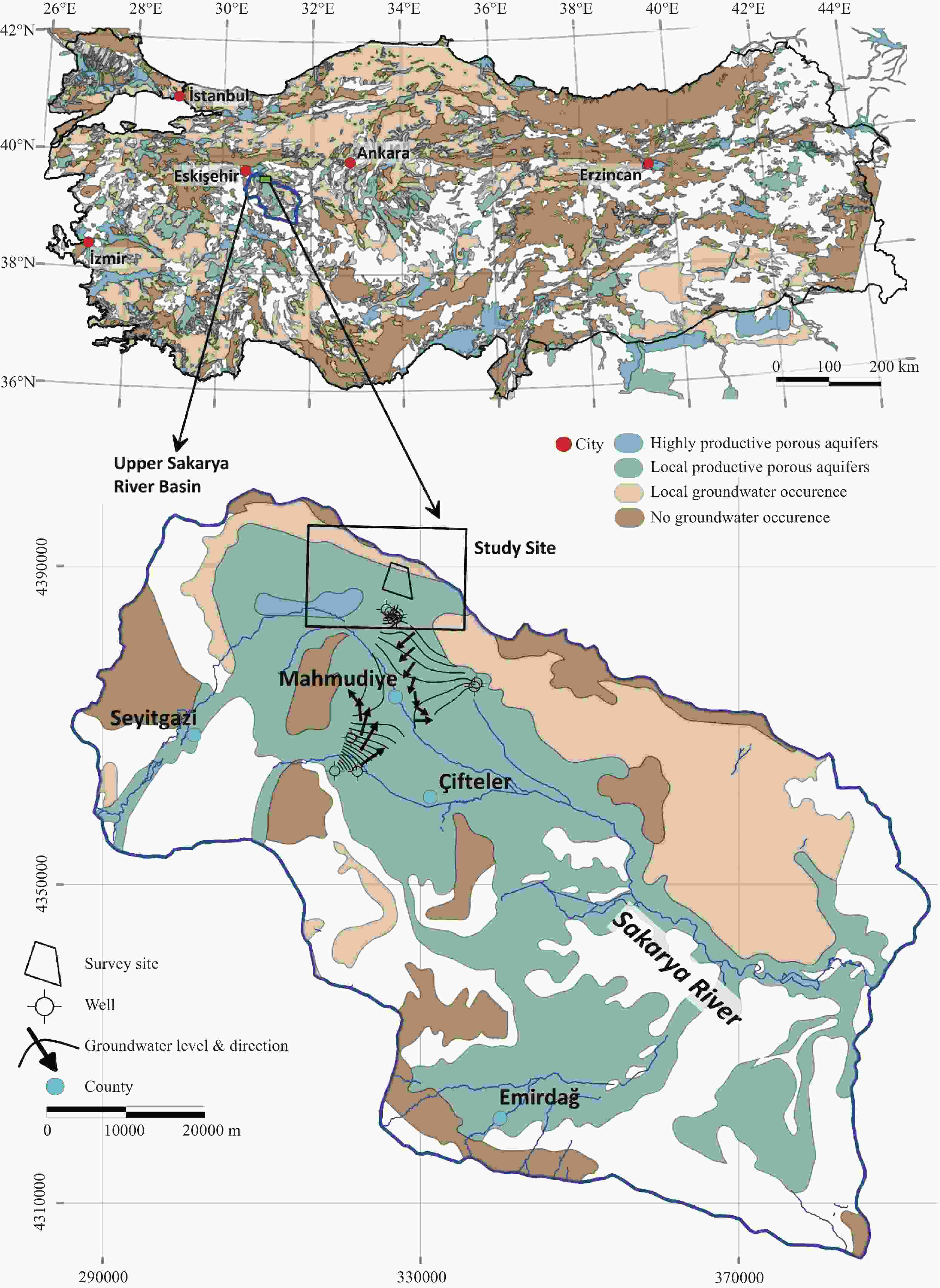
Figure 2. The regional hydrogeology map of Türkiye compiled from IHME (2021) and the hydrogeology map of the Upper Sakarya River Basin compiled from IHME (2021) and Esen (1978).
Notes: The map only displays the high and local groundwater aquifers with no groundwater occurrence settings. The study site, the survey site (the geophysical survey site) and the local groundwater level map are on the figure. The figure uses Universal Transverse Mercator projection with WGS 84 datum in 36 Northern Hemisphere Zone.
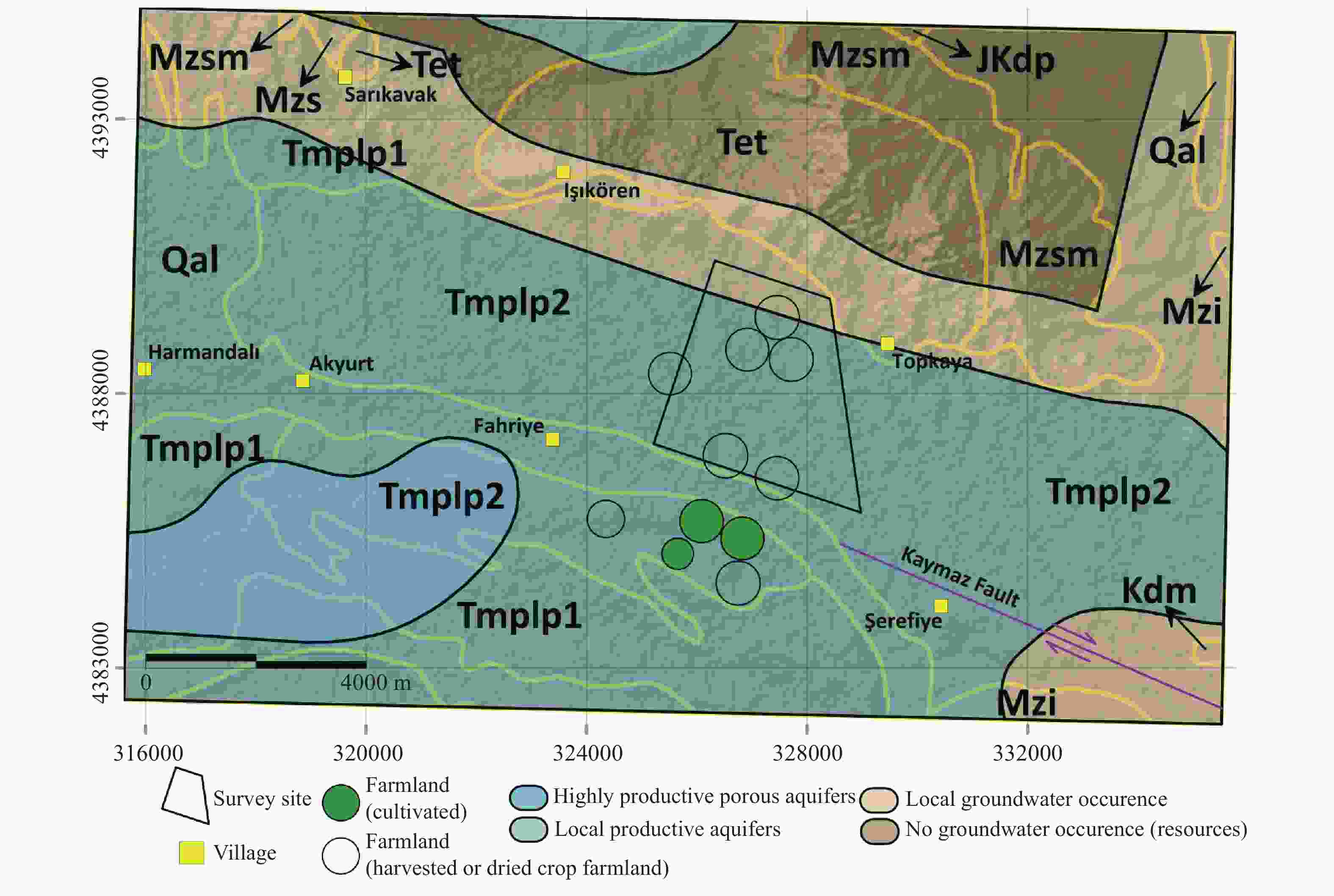
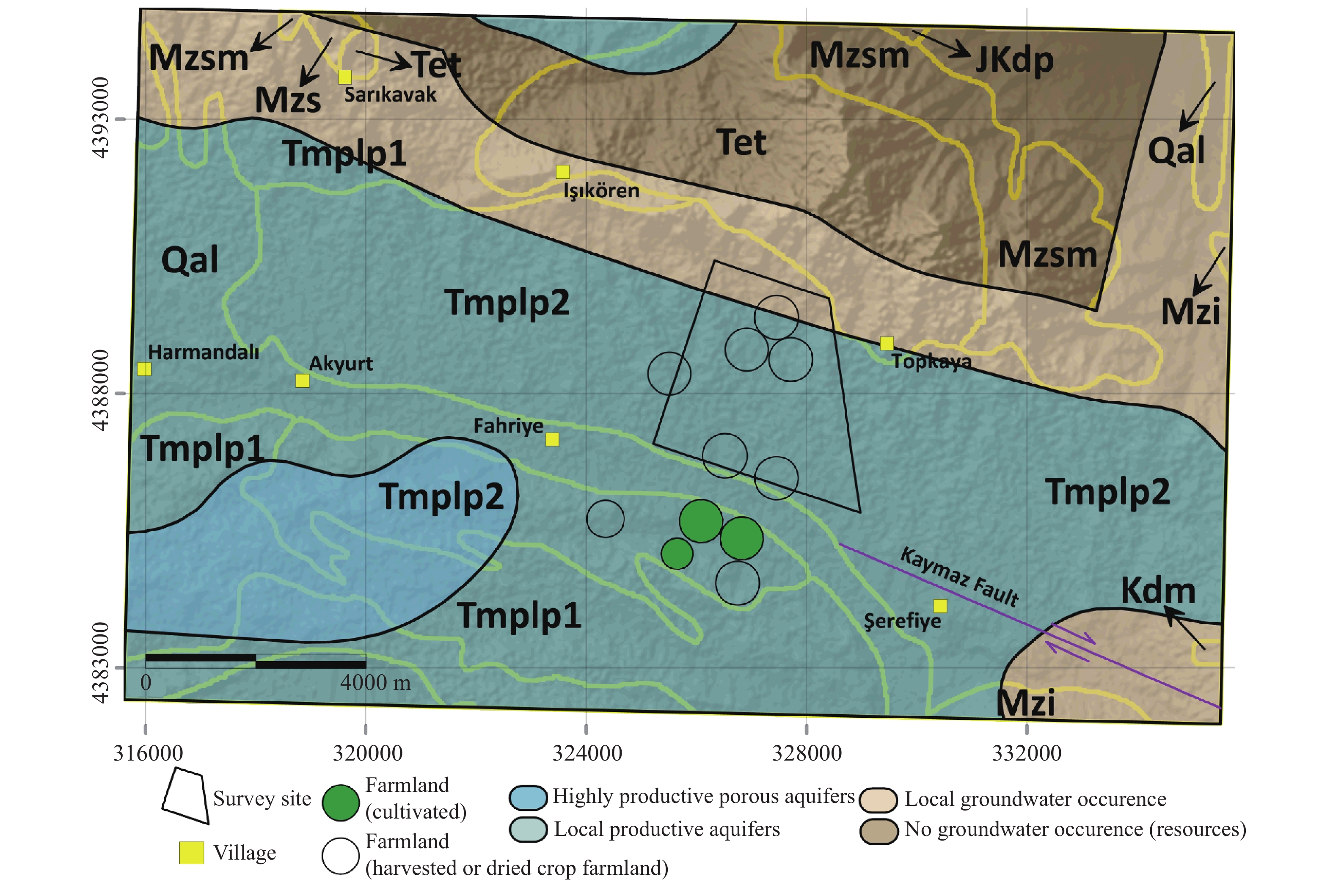
Figure 3. The hydrogeology map of the study site (the geophysical survey site) compiled from Akbaş et al. (2011), Emre et al. (2013, 2018) and IHME (2021).
Notes: The yellow lines indicate boundaries of the outcropped rocks. The abbreviations on the figure reveal the stratigraphic names of the rocks in Fig. 1. The figure uses Universal Transverse Mercator projection with WGS 84 datum in 36 Northern Hemisphere Zone.
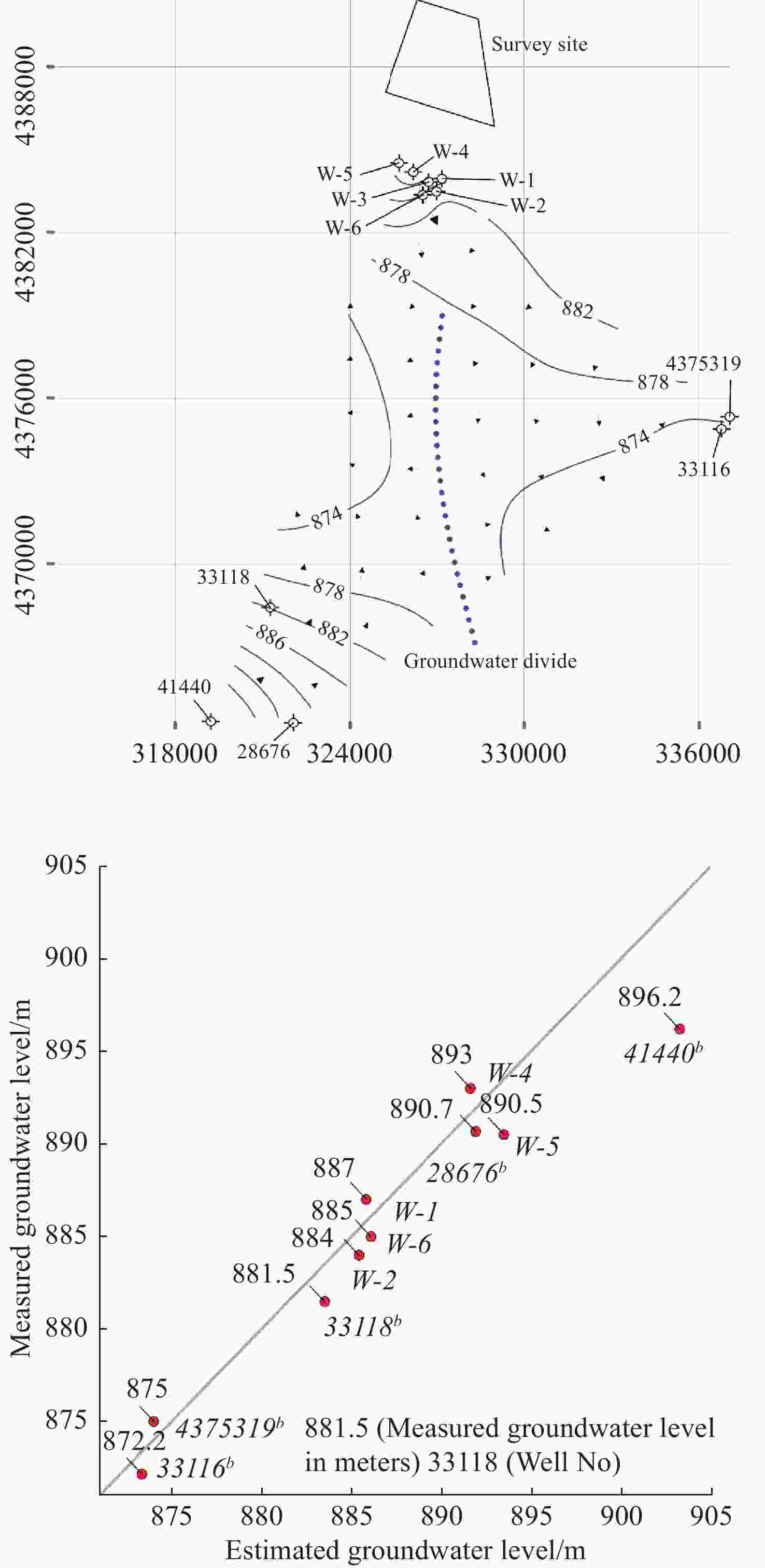
Figure 4. The groundwater level map in meters above mean sea level (MSL) close to the survey site (the geophysical survey site) and the two main groundwater flow directions are visible and separated with the groundwater divide.
Notes: The map was prepared with the groundwater depth data in Table 1 compiled from TİGEM (2012) and DSİ Data Archive (the data obtained by personal communication). The upper figure uses Universal Transverse Mercator projection with WGS 84 datum in 36 Northern Hemisphere Zone. The lower figure is the graph of measured groundwater level data in meters above MSL vs. estimated groundwater level values produced by the Minimum Curvature method (Briggs, 1974). The gray line is the 1:1 line. The measured data and well numbers were labeled with red dots.
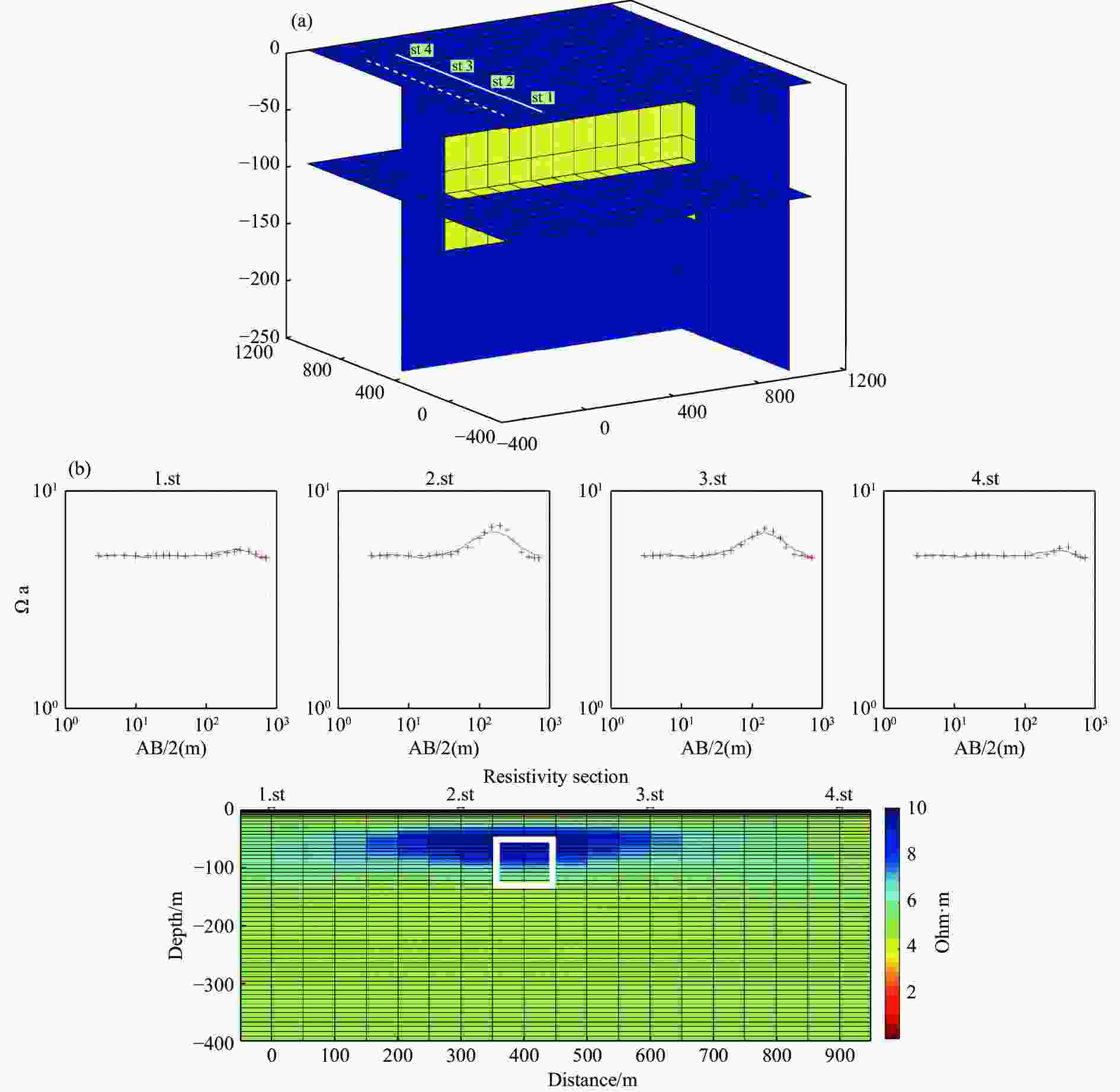
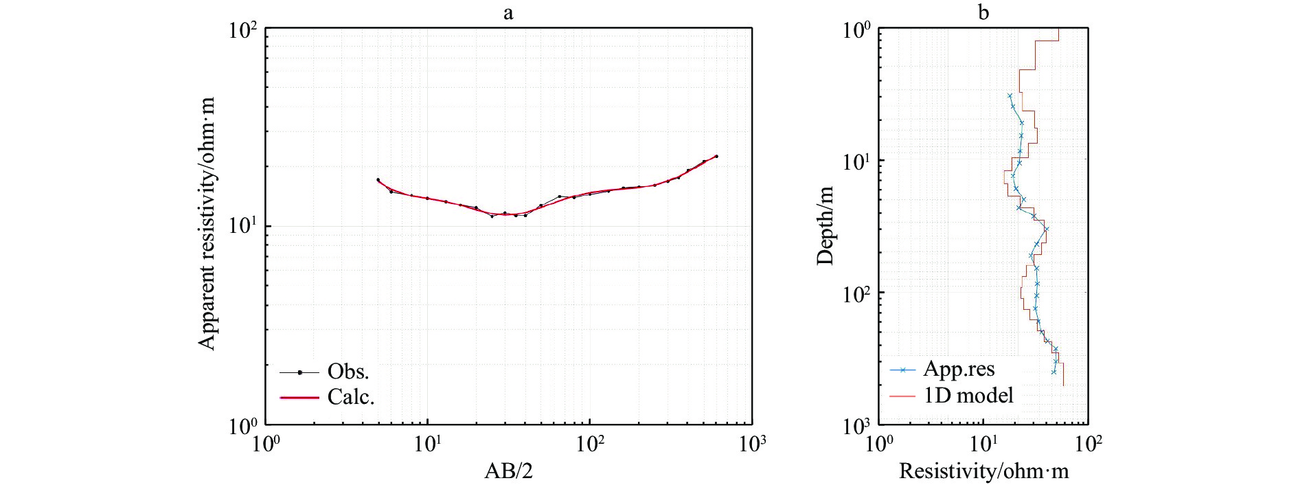
Figure 6. a) Synthetic model with finite length prism. Solid line profile for observable data. See text for dashed lines. b) 2D inversion result of synthetic data. The white box is the location of the prism.
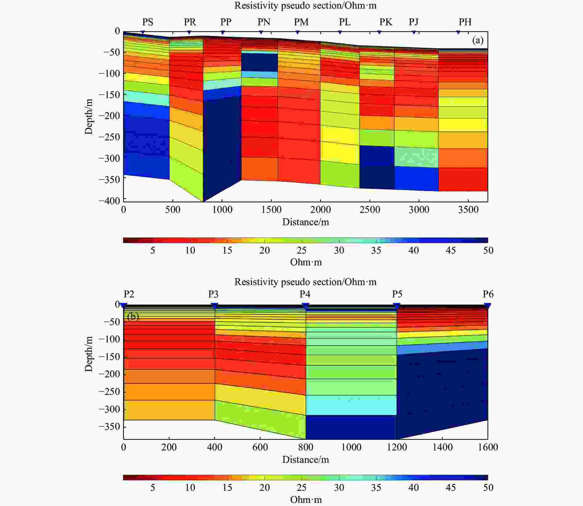
Figure 8. a) Stitched presentation of 1D Occam’s inversion result along the 5th station for each profile. b) Stitched presentation of 1D Occam’s inversion result along the Profile P
Table 1. The wells with their hydraulic test data close to the survey site
Well No Drilling date Depth (m) Static level (m) Dynamic level (m) Flow (lt/sn) W-1a 2009 150 22 25 40 W-2a 2009 150 28 30.5 30 W-4a 2009 156 24 31 33 W-5a 2009 161 30.5 60 6 W-6a 2009 152 12 17 53 28676b n/a 144 19.33 n/a n/a 33116b n/a 102 2.81 n/a n/a 33118b n/a 197 27.51 n/a n/a 41440b n/a 200 15.81 n/a n/a 4375319b n/a 92 4.96 n/a n/a Notes: The data compiled from TİGEM (2012) and General Directorate of State Hydraulic Works Data Archive by personal communication and the well locations are shown in Fig. 2 and Fig. 4.
n/a (no answer or no information verified)
a The groundwater depth from 2009, not including any season or duration
b The groundwater depth given as an arithmetic mean from 2009. By doing so, the data could be reduced to represent those from 2009 and handled to map with the data outlined in the first five columns 下载: 导出CSV
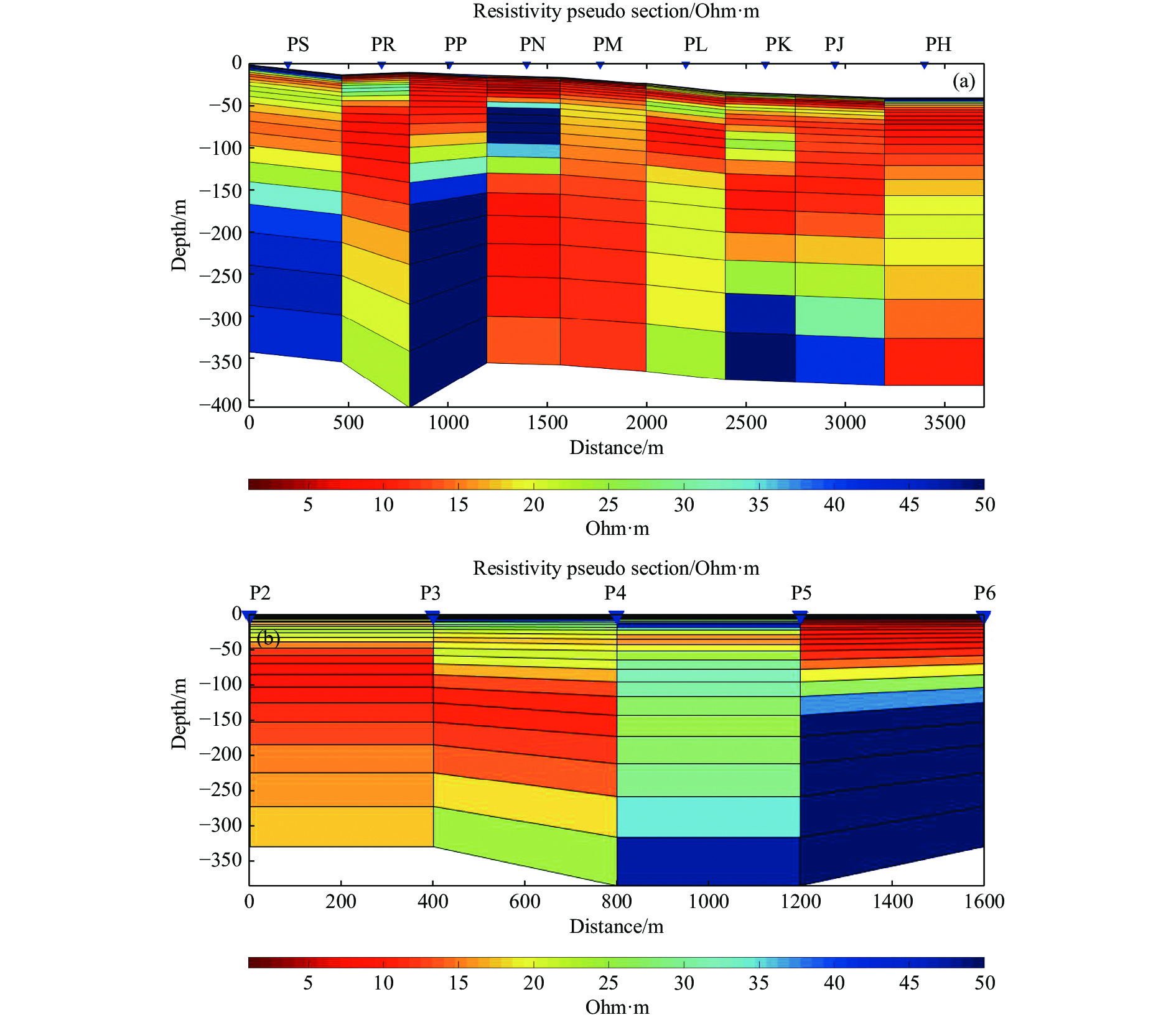
Table 2. Profile names, distance between first and last station and number of stations
Profile Name PH PJ PK PL PM PN PP PR PS Length 3600 3200 2800 2400 2000 1600 1600 2000 2000 # of stations 10 9 8 7 6 5 5 6 6
下载: 导出CSV
Table 3. Variation of misfit values in 2D inversion
Profiles PH PJ PK PL PM PN PP PR PS Initial misfit 7.8055 7.032 4.2337 5.3224 5.3085 4.1086 6.0178 9.2251 6.8185 Final misfit 0.0956 0.0536 0.0629 0.0480 0.0440 0.0283 0.03428 0.1734 0.2197 Iteration 100 100 100 100 86 100 100 99 74
下载: 导出CSV
-
Akbaş B, Akdeniz N, Aksay A, et al. 2011. 1:1 250 000 scale geological map of Turkey. General Directorate of Mineral Research and Exploration Publication: Ankara−Turkey. Araffa SA, Mohamadin MI, Saleh Sabet H, et al. 2019. Geophysical interpretation for groundwater exploration around Hurghada area, Egypt. Journal of Astronomy and Geophysics, 8(1): 171−179. doi: 10.1080/20909977.2019.1647389 Awotoye KS, Selemo AO. 2006. Design and construction of a resistivity meter for shallow investigation. Nigerian Journal of Physics, 18(2): 261−270. doi: 10.4314/njphy.v18i2.38113 Bhattacharya BB, Shalivahan S. 2016. Geoelectric methods: Theory and application. McGraw-Hill Education. ISBN: 9789339221379 Boubaya D. 2017. Combining resistivity and aeromagnetic geophysical surveys for groundwater exploration in the Maghnia plain of Algeria. Journal of Geological Research: 1309053. Briggs IC. 1974. Machine contouring using minimum curvature. Geophysics, 39(1): 39−48. doi: 10.1190/1.1440410 Clark JA, Page R. 2011. Inexpensive geophysical instruments supporting groundwater exploration in developing nations. Journal of Water Resource and Protection, 3(10): 768. doi: 10.4236/jwarp.2011.310087 Constable SC, Parker RL, Constable CG. 1987. Occam’s inversion: A practical algorithm for generating smooth models from electromagnetic sounding data. Geophysics, 52(3): 289−300. doi: 10.1190/1.1442303 EARTHDATA. 2021. SRTM Elevation Data of 1 arc-second. (A.D. 19.08.2021) Ekinci YL, Demirci A. 2008. A damped least-squares inversion program for the interpretation of Schlumberger sounding curves. Journal of Applied Sciences, 8(22): 4070−4078. doi: 10.3923/jas.2008.4070.4078 Emre Ö, Duman TY, Özalp S, et al. 2013. Active fault map of Turkey with explanatory text. General Directorate of Mineral Research and Exploration Special Publication Series: 30. Emre Ö, Duman TY, Özalp S, et al. 2018. Active fault database of Turkey. Bulletin of Earthquake Engineering, 16(8): 3229−3275. doi: 10.1007/s10518-016-0041-2 Esen E. 1978. Hydrogeological Investigation Report of Yukarı Sakarya Basin (in Turkish), General Directorate of State Hydraulic Works, 147, Ankara, Turkey Fitts CR. 2013. Groundwater Science (2nd edn). Elsevier. Florsch N, Muhlach F. 2017. Everyday applied geophysics 1: Electrical methods. Elsevier. Freeze RA, Cherry JA. 1979. Groundwater. Prentice-Hall Inc. Eaglewood Cliffs, New Jersey. ISBN: 0133653129 Fretwell JD, Stewart MT. 1981. Resistivity study of a coastal karst terrain, Florida. Ground Water, 19: 156−162. doi: 10.1111/j.1745-6584.1981.tb03454.x Gallardo LA, Meju MA. 2007. Joint two-dimensional cross-gradient imaging of magnetotelluric and seismic traveltime data for structural and lithological classification. Geophysical Journal International, 169(3): 1261−1272. doi: 10.1111/j.1365-246X.2007.03366.x GMVDE 2016. Geoscience Map Viewer and Drawing Editor Version 2.9, (AD 19.08.2021) Igboama WN, Ugwu NU. 2011. Fabrication of resistivity meter and its evaluation. American Journal of Scientific and Industrial Research, 2(5): 713−717. doi: 10.5251/ajsir.2011.2.5.713.717 IHME. 2021. International Hydrogeological Map of Europe 1: 1 500 000 scale. (AD 19.08.2021). Jones AG. 1983. On the equivalence of the “Niblett” and “Bostick” transformations in the magnetotelluric method. Journal of Geophysics, 53(1): 72−73. Kanar F, Kandemir Ö. 2018. 1: 100 000 Scaled Turkey Geological Map Series Eskişehir-İ25 Sheet (in Turkish), General Directorate of Mineral Research and Exploration Publication, Ankara, Turkey. Lee CH. 1915. The determination of safe yield of underground reservoirs of the closed-basin type. Transactions of the American Society of Civil Engineers, 98: 148−218. Loke MH, Barker RD. 1996a. Rapid least-squares inversion of apparent resistivity pseudo sections by a quasi-Newton method. Geophysical Prospecting, 44(1): 131−152. doi: 10.1111/j.1365-2478.1996.tb00142.x Loke MH, Barker RD. 1996b. Practical techniques for 3D resistivity surveys and data inversion. Geophysical prospecting, 44(3): 499−523. doi: 10.1111/j.1365-2478.1996.tb00162.x Maliva RG. 2016. Aquifer characterization techniques. Berlin: Springer. ISBN: 978-3-319-32137-0 Meju MA. 1994. Geophysical Data Analysis: Understanding Inverse Problem Theory and Practice: SEG Course Notes Series, 6: Tulsa: SEG. Meju MA. 2002. Geoelectromagnetic exploration for natural resources: Models, case studies and challenges. Surveys in Geophysics, 23(2−3): 133−206. doi: 10.1023/A:1015052419222 Menke W. 1989. Geophysical data analysis: Discrete inverse theory. Academic press. Mikailu A, Abdullahi I, Sani MG, et al. 2015. Development of Digital Resistivity Meter. Advances in Physics Theories and Applications, 42. ISSN 2224-719X MTA. 1964. The general directorate of mineral research and exploration. Geological map of Turkey (1:500 000 scale). Ankara: Turkey. Nwankwo LI. 2011. 2D resistivity survey for groundwater exploration in a hard rock terrain: A case study of MAGDAS observatory, UNILORIN, Nigeria. Journal of Asian Earth Sciences, 4(1): 46−53. doi: 10.3923/ajes.2011.46.53 Okay AI, Tüysüz O. 1999. Tethyan sutures of northern Turkey. Geological Society, London, Special Publications. 156(1): 475-515. Okay AI. 2011. Tavşanli Zone: The northern subducted margin of the Anatolide-Tauride block. Bulletin of the Mineral Research and Exploration, 142: 191−211. Oldenburg DW, Li Y. 1999. Estimating depth of investigation in dc resistivity and IP surveys. Geophysics, 64(2): 403−416. doi: 10.1190/1.1444545 Olorunfemi MO, Fasuyi SA. 1993. Aquifer types and the geoelectric/hydrogeologic characteristics of part of the central basement terrain of Nigeria (Niger State). Journal of African Earth Sciences (and the Middle East), 16(3): 309−317. doi: 10.1016/0899-5362(93)90051-Q Özürlan G, Candansayar ME, Şahin HM. 2006. Deep resistivity structure of Dikili-Bergama region, West Anatolia, revealed by two dimensional inversion of vertical electrical sounding data. Geophysical Prospecting, 54: 187−197. doi: 10.1111/j.1365-2478.2006.00525.x Palacky GJ. 1987. Clay mapping using electromagnetic methods. First Break, 5(8): 295−306. doi: 10.3997/1365-2397.1987015 Rijo L, Pelton WH, Feitosa EC, et al. 1977. Interpretation of apparent resistivity data from Apodi Valley, Rio Grande DoNorte, Brazil. Geophysics, 42: 811−822. doi: 10.1190/1.1440749 Roy A, Apparao A. 1971. Depth of investigation in direct current methods. Geophysics, 36(5): 943−959. doi: 10.1190/1.1440226 Saad R, Nawawi MNM, Mohamad ET. 2012. Groundwater detection in alluvium using 2-D electrical resistivity tomography (ERT). Electronic Journal of Geotechnical Engineering, 17: 369−376. Sasaki Y, Meju MA. 2006. A multidimensional horizontal-loop controlled-source electromagnetic inversion method and its use to characterize heterogeneity in aquiferous fractured crystalline rocks. Geophysical Journal International, 166(1): 59−66. doi: 10.1111/j.1365-246X.2006.02957.x Shaaban FF. 2001. Vertical electrical soundings for groundwater investigation in northwestern Egypt: A case study in a coastal area. Journal of African Earth Sciences, 33(3−4): 673−686. doi: 10.1016/S0899-5362(01)00092-6 Surfer. 2020. Contouring, gridding, and 3D surface mapping software (Software Version 18), Golden Software, Colorado, USA Swartz JH. 1937. Resistivity studies of some salt-water boundaries in the Hawaiian Islands. Eos, Transactions American Geophysical Union, 18(2): 387-393. doi: 10.1029/TR018i002p00387 Swartz JH. 1939. Resistivity studies of some salt-water boundaries in the Hawaiian Islands Part II. Eos, Transactions American Geophysical Union, 20: 292. doi: 10.1029/TR020i003p00292 Szalai S, Novák A, Szarka, L. 2009. Depth of investigation and vertical resolution of surface geoelectric arrays. Journal of Environmental and Engineering Geophysics, 14(1): 15−23. doi: 10.2113/JEEG14.1.15 Telford WM, Geldart LP, Sheriff RE (editors). 1990. Applied Geophysics. Cambridge, UK: University Press. Ulugergerli EU. 2017. Marine effects on vertical electrical soundings along shorelines. Turkish Journal of Earth Sciences, 26(1): 57−72. doi: 10.3906/yer-1610-10 USGS. 2021. https://www.usgs.gov/special-topic/water-science-school/science/groundwater-decline-and-depletion?qt-science_center_objects=0#qt-science_center_objects. Accessed 06/07/2021 Vedanti N, Srivastava RP, Sagode J, et al. 2005. An efficient 1D Occam’s inversion algorithm using analytically computed first-and second-order derivatives for DC resistivity soundings. Computers and Geosciences, 31(3): 319−328. doi: 10.1016/j.cageo.2004.10.015 Werkema Jr DD, Atekwana E, Sauck W, et al. 1998. A versatile Windows based multi-electrode acquisition system for dc electrical methods surveys. Environmental Geosciences, 5(4): 196−206. doi: 10.1046/j.1526-0984.1998.08027.x Yang X, Lagmanson M. 2006. Comparison of 2D and 3D electrical resistivity imaging methods. In 19th EEGS Symposium on the Application of Geophysics to Engineering and Environmental Problems (pp. cp-181). European Association of Geoscientists and Engineers. Zhdanov MS, Keller GV. 1994. The geoelectrical methods in geophysical exploration (Vol. 31). Elsevier Science Limited. ISBN-10: 0444896783. Zürcher L, Bookstrom AA, Hammarstrom JM, et al. 2010. Porphyry copper assessment of the Tethys region of western and southern Asia: U. S. Geological Survey Scientific Investigations Report 2010–5090–V, 232, and spatial data. -


 点击查看大图

计量
- 文章访问数: 1714
- HTML全文浏览量: 647
- PDF下载量: 78
- 被引次数: 0


