 E-mail alert
 Rss
Rss

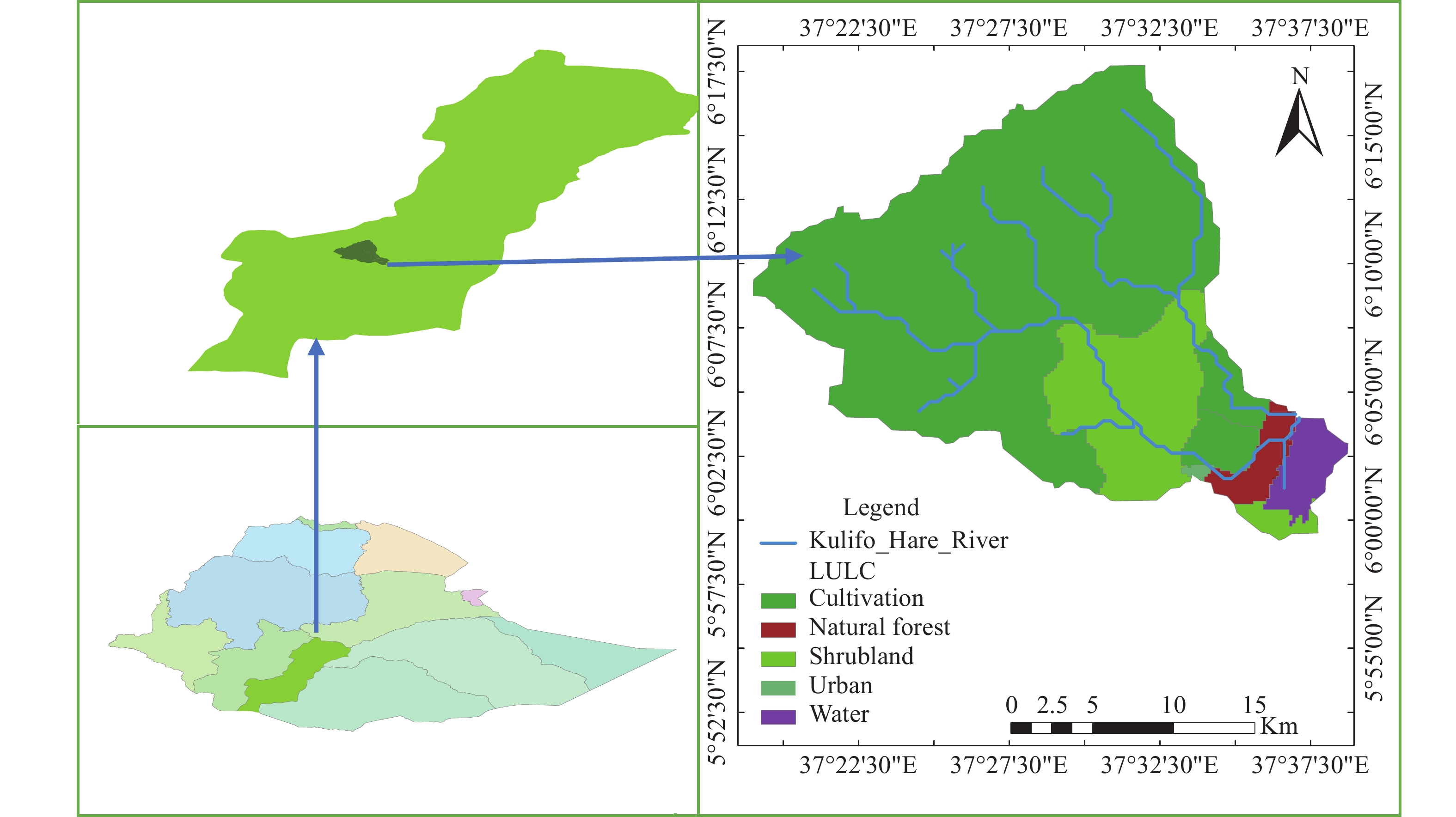
Determination of groundwater potential distribution in Kulfo-Hare watershed through integration of GIS, remote sensing, and AHP in Southern Ethiopia
-
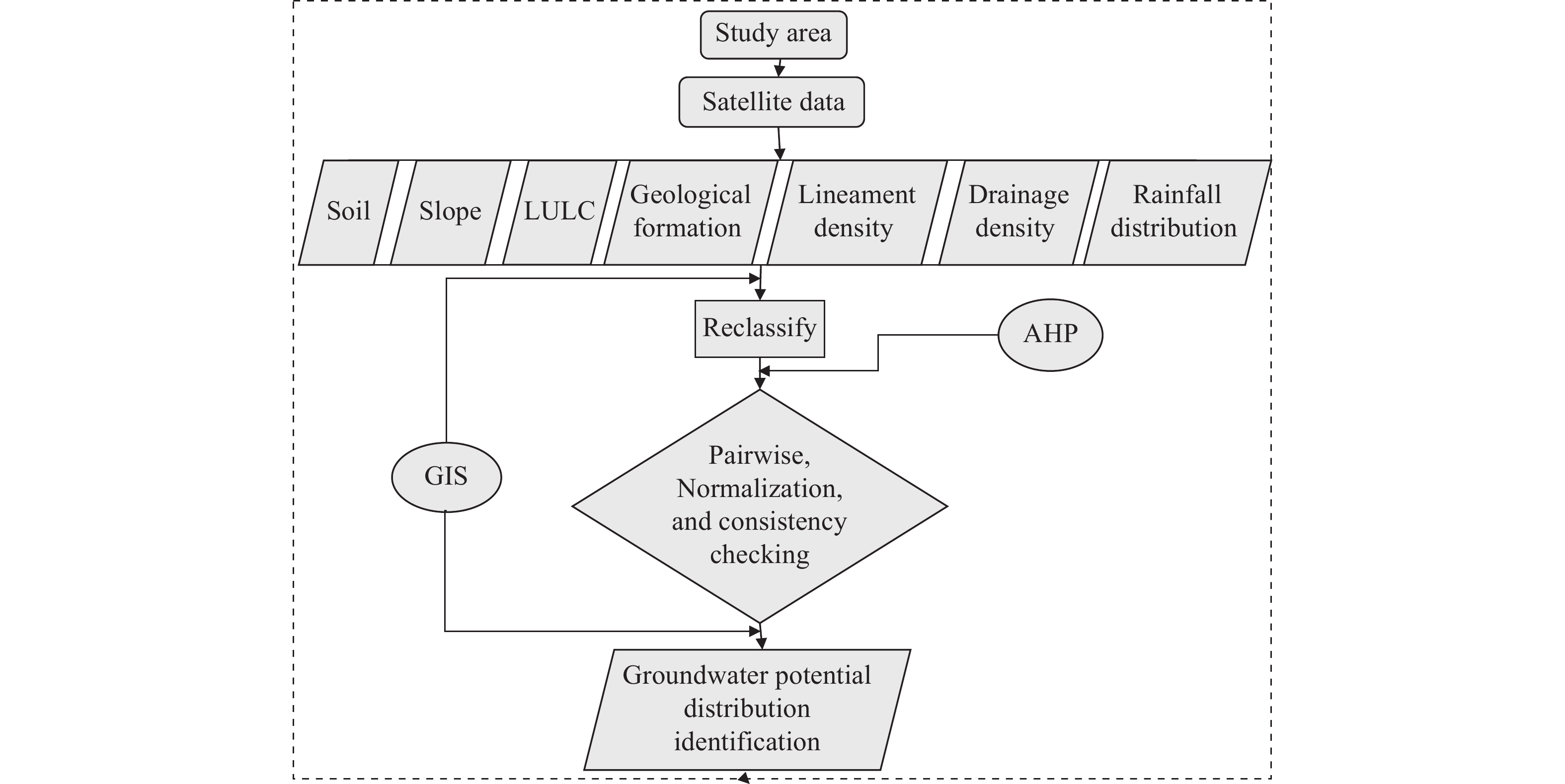
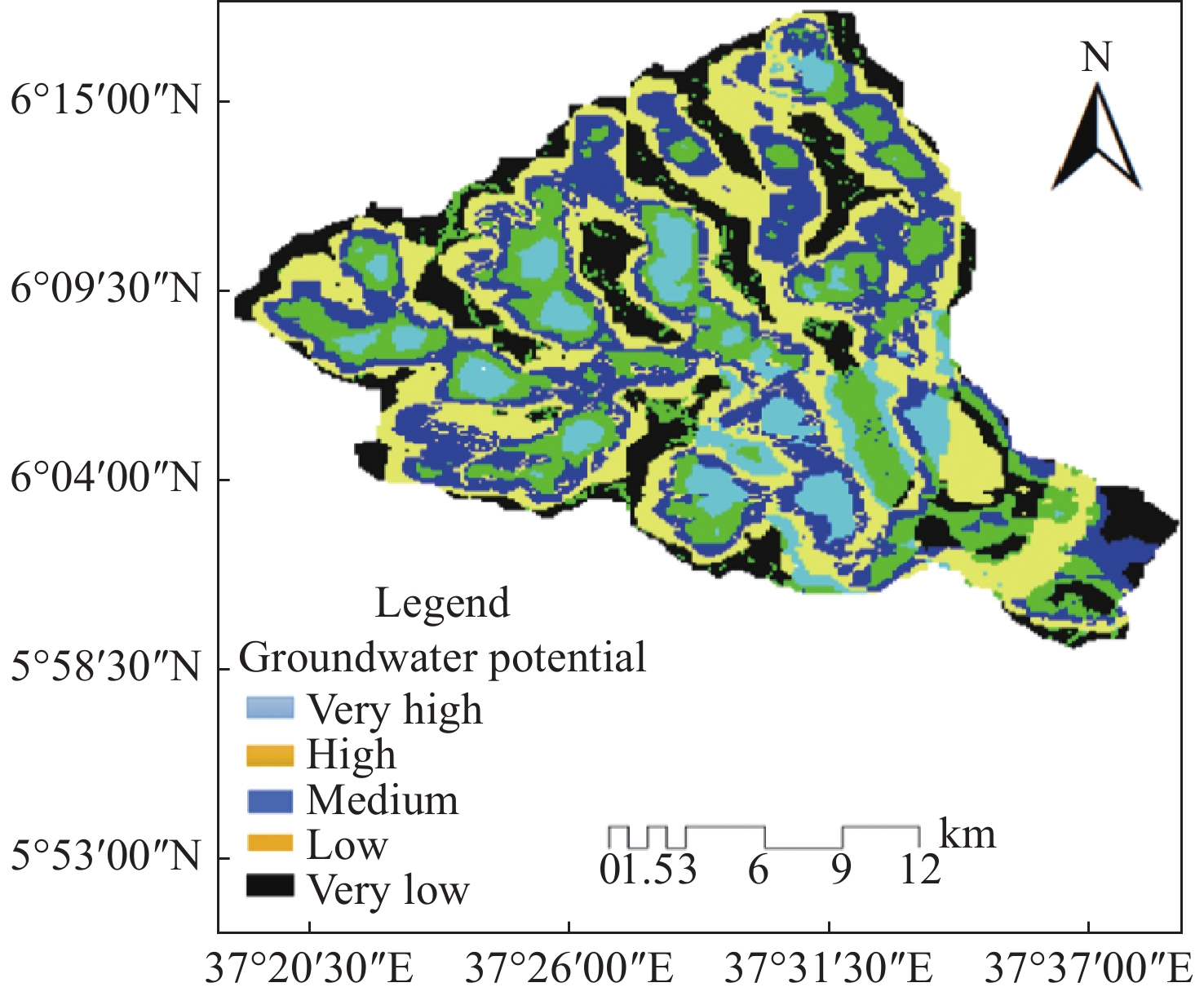
Abstract: Identification of groundwater potential areas (GPA) is important in regions facing surface water scarcity, as it assists in effective planning and utilization of groundwater for various purposes. This study employs the methods of remote sensing (RS), geographic information system (GIS) model, and analytical hierarchy process (AHP), multi-criteria decision analysis (MCDA) to locate and map the prospective groundwater areas in the Kulfo-Hare watershed. Seven significant groundwater influencing factors were selected for the determination of groundwater potential in the area: Geology, land use/land cover (LULC), soil, rainfall, slope, drainage density, and lineament density. By applying a five-class classification scheme (very low, low, moderate, high, and very high), the GIS models were used to define the distribution of groundwater potential areas in terms of area coverage (km2), percentage and mapping. The results show that the groundwater potential (GWP) distribution in the research region is as follows: 9.7% (6 035.9 ha) classified as very high GWP, 29.6% (18 606 ha) classified as high, 24.5% (15 245 ha) classified as moderate, 18.1% (11 431 ha) as low and 18.1% (11 492 ha) very low GWP, on the basis of the weighted overlay evaluation. Although a few regions are identifies as extremely low GWP, most of the study area is characterized by very high to moderate GWP. These findings provide valuable insight for sustainable groundwater planning by the government bodies, decision-makers, and private sectors.
-
Table 1. Groundwater potential estimation factors and their sources
Factors Data source Data details Source reference Slope ASTER GDEM Version 3, (30 × 30) m https://search.earthdata.nasa.gov Drainage density ASTER GDEM Version 3, (30 × 30) m https://search.earthdata.nasa.gov Geology Geological survey ASTER Data vector layer: 11 091 958 https://search.earthdata.nasa.gov Lineament density Geological survey ASTER Data vector layer: 11 091 958 https://search.earthdata.nasa.gov Land use/land cover USGS Landsat 8 (30 × 30) m https://earthexplorer.usgs.gov Soil FAO
Digital soil map of the World http://www.fao.org Rainfall CRUTS v. 4.04 High-resolution gridded data, 0.5°×0.5° https://sites.uea.ac.uk/cru/da  下载: 导出CSV
Table 2. Importance scale (1-9) and random consistency index (RI) (Saaty, 1999)
Intensity 1 2 3 4 5 6 7 8 9 Definition Equal Weak Moderate Moderate plus Strong Strong plus Very strong Very very strong Extreme
RI value 0 0 0.58 0.9 1.12 1.24 1.32 1.41 1.45
下载: 导出CSV
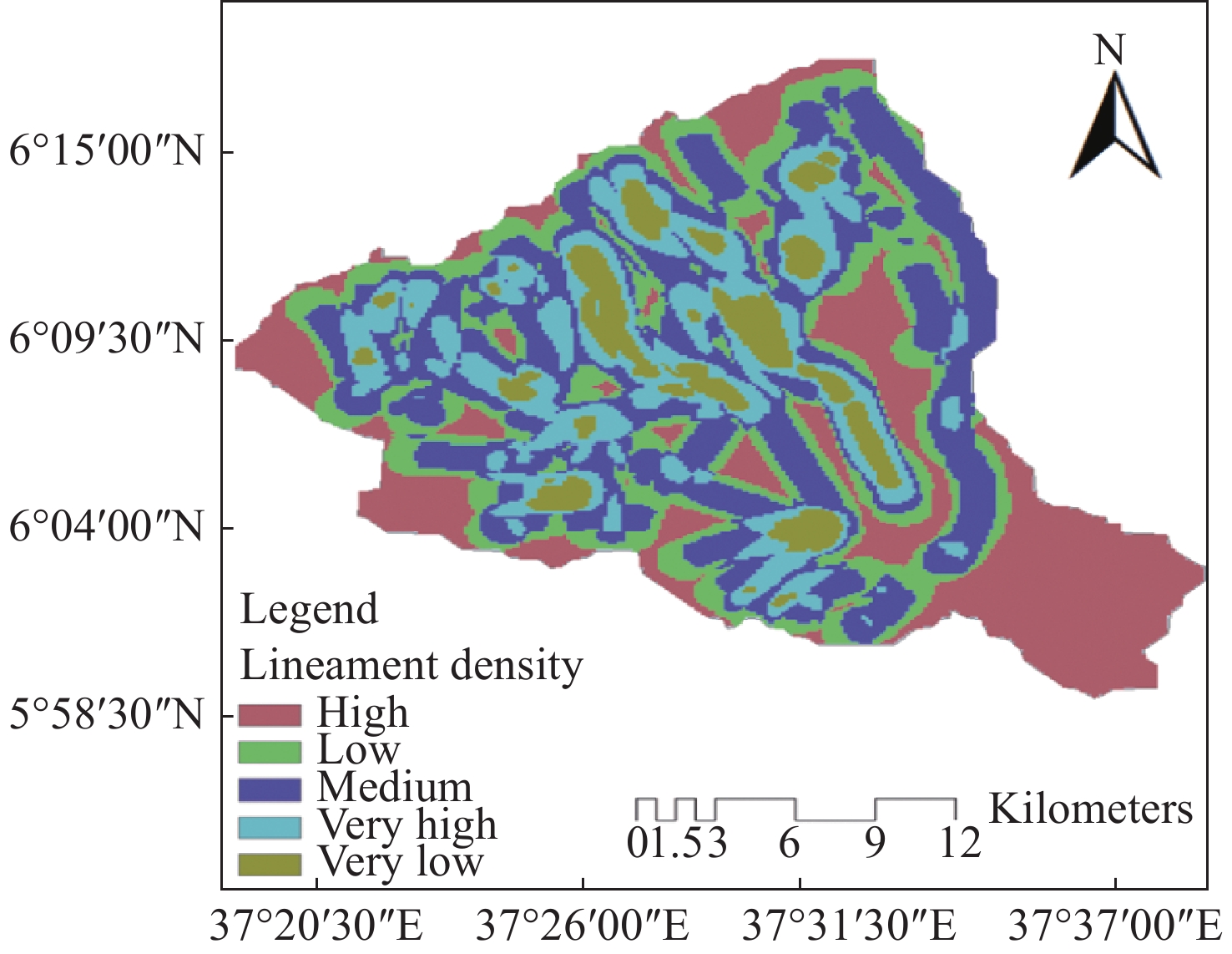
Table 3. Distribution of Lineament density suitability in the area and percent
No. Area / km2 Area / km2 Suitability class 1 55.10 8.85 Very low 2 110.72 17.78 Low 3 190.6 30.61 Moderate 4 160.1 25.71 High 5 106.17 17.05 Very high
下载: 导出CSV
Table 4. Distribution of LULC suitability in area and percentage
No. LULC class Suitability classification Area / km2 Area / % 1 Agriculture cultivation land Very high 487.51 78.29 2 Water bodies High 20.68 3.32 3 Shrub land High 105.45 16.93 4 Natural forest Moderate 16.86 2.71 5 urban Very low 1.55 0.25
下载: 导出CSV
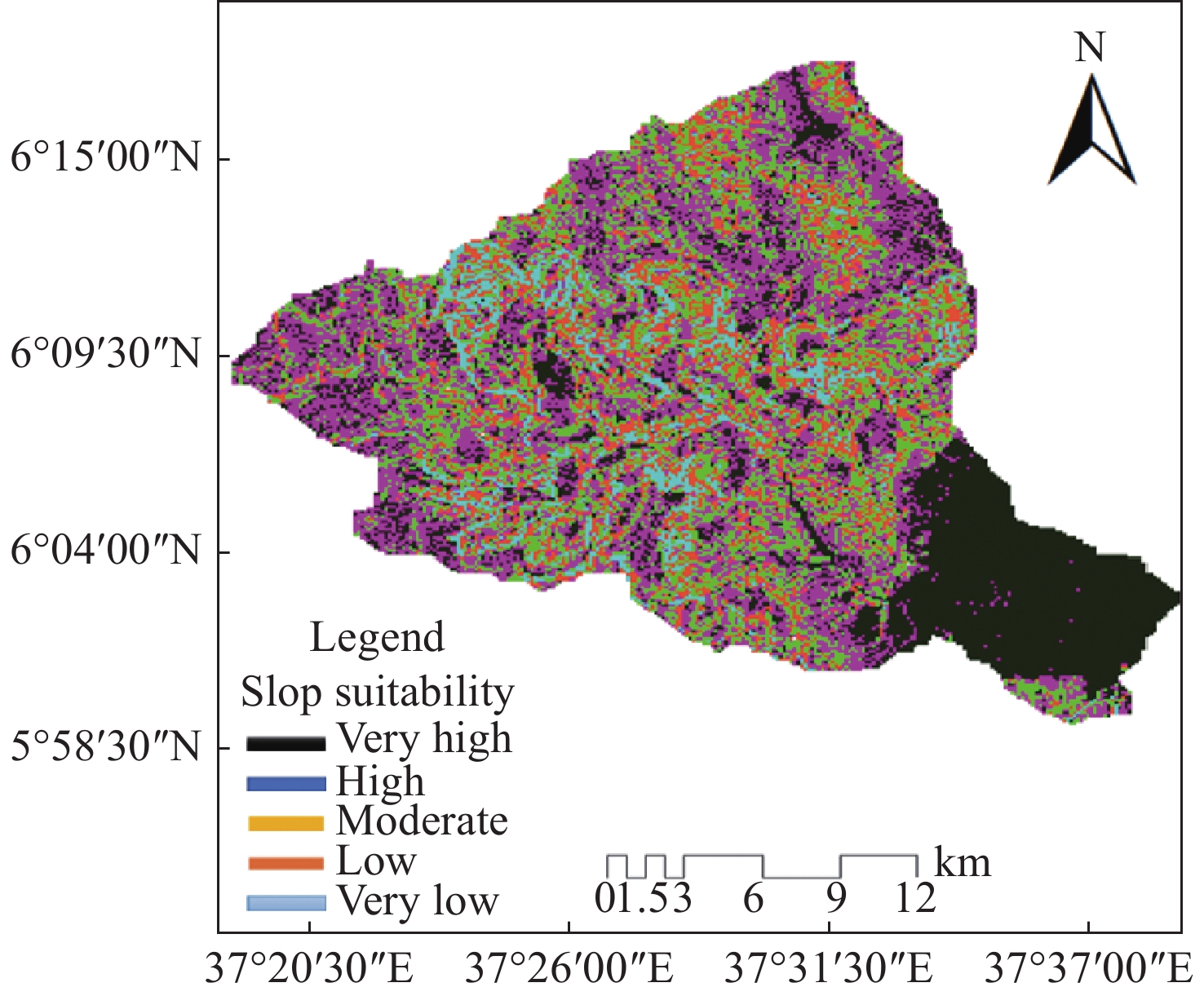
Table 5. Slope suitability distribution in area and percentage
No. Slope classification Slope classification Suitability class Area / km2 Area / % 1 <7° Gentle slope Very high 151.11 24.4 2 7–15° Moderate slope High 191.71 30.8 3 15–24° Strong slope Moderate 140.45 23.2 4 24–34° Steep slope Low 98.66 16.1 5 > 34° Very steep slope Very Low 40.76 6.5
下载: 导出CSV
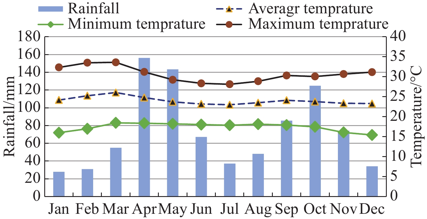
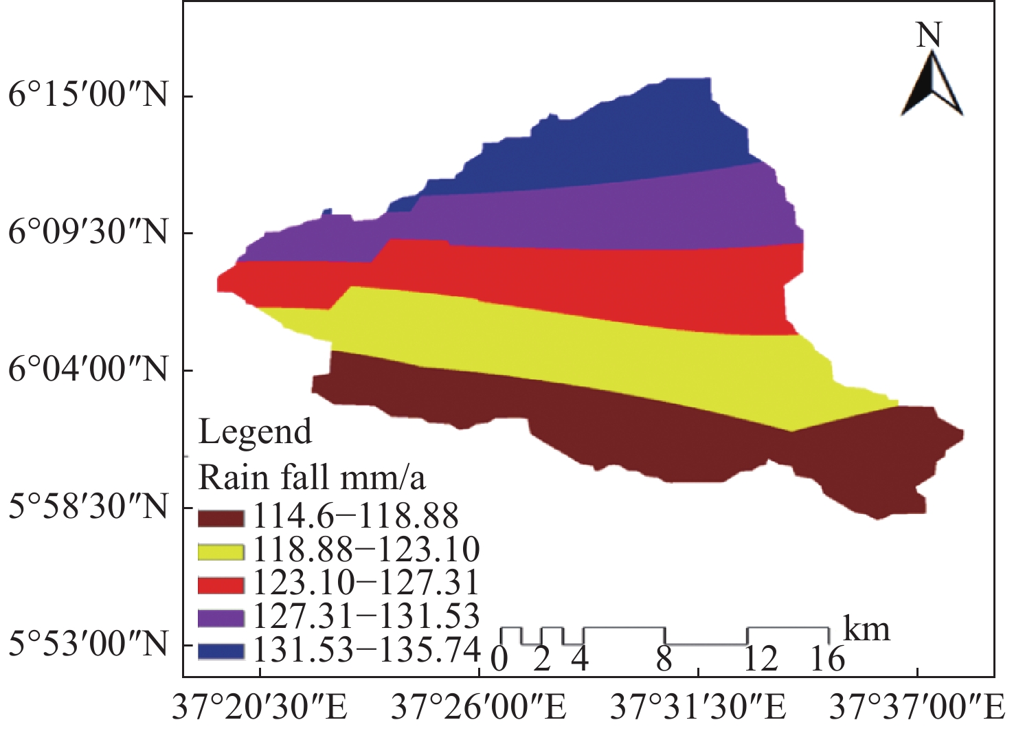
Table 6. Distribution of rainfall suitability in area and percentage
No. Rainfall classification / mm Suitability class Area
/ km2Area
/ %1 114.60–118.88 Very Low 150.33 24.14 2 118.88–123.10 Low 142.31 22.85 3 123.10–127.31 Moderate 130.2 20.91 4 127.31–131.53 High 116.35 18.69 5 131.53–135.74 Very high 83.5 13.41
下载: 导出CSV
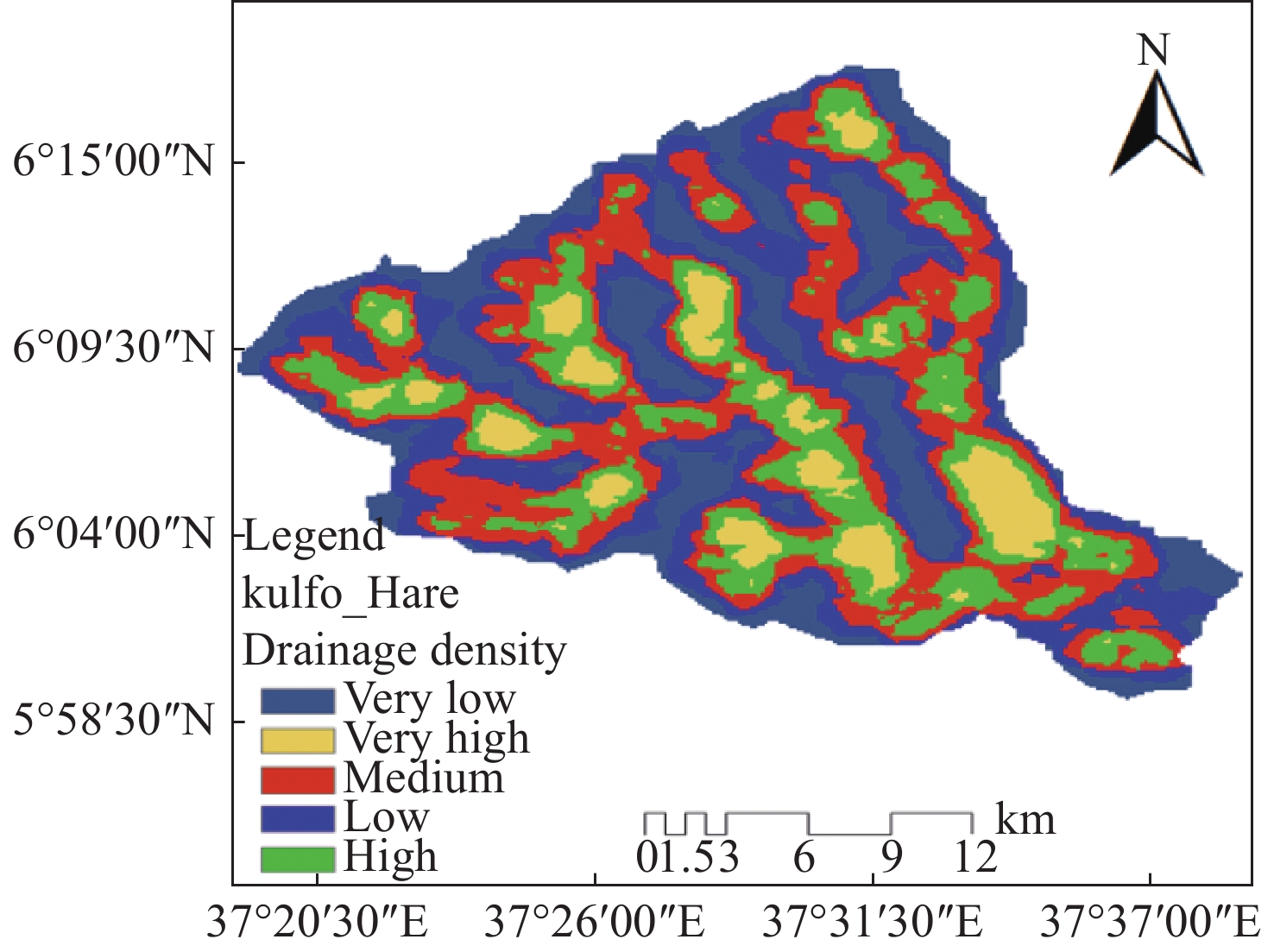
Table 7. Distribution of drainage density suitability in area and percent
No. Area / km2 Area / % Suitability class 1 127.87 20.54 Very Low 2 120.41 19.34 Low 3 156.38 25.11 Moderate 4 144.95 23.28 High 5 73.08 11.73 Very high
下载: 导出CSV
Table 8. Pairwise comparison matrix of 7 groundwater factors from the AHP model
Factors LULC Soil Geology RF Drainage density Lineament density Slope LULC 1 1 3 3 9 9 9 Soil 1 1 3 3 9 7 9 Geology 1/3 1/3 1 1 1 3 3 RF 1/3 1/3 1 1 3 3 3 Drainage density 1/9 1/9 1 1/3 1 1 3 lineament Density 1/9 1/7 1/3 1/3 1 1 3 Slope 1/9 1/9 1/3 1/3 1/3 1/3 1
下载: 导出CSV
Table 9. Groundwater potential factors normalized weight using AHP and their sub-classes rank
Factors Groundwater potential factors classes Groundwater potential factors suitability AHP normalized weights Influence
/ %The rank of sub-classes based on Saaty's scale Lineament density 0–0.2
0.2–0.4
0.4–0.6
0.6–0.8
0.8–1.08Very low
Low
Moderate
High
Very high0.03 3 1
3
5
7
9LULC Cultivation land
Water bodies
Shrub land
Natural forest
UrbanVery high
High
High
Moderate
Very low0.05 5 9
9
8
5
1Geology formation Quaternary extrusive and intrusive rocks
Tertiary extrusive and intrusive rockVery high
Very high0.34 34 9
9Slope <7° (Gentle)
7–15° (Moderate)
15–24° (Strong)
24–34° (Steep)
> 34° (Very steep)Very high
High
Moderate
Low
Very Low0.1 10 9
7
5
3
1Annual Rainfall (mm) 114.60–118.88
118.88–123.10
123.10–127.31
127.31–131.53
131.53–135.74Very Low
Low
Moderate
High
Very high0.32 32 2
4
6
8
9Soil property Loam
Sandy loamHigh
Very high0.11 11 9
8Drainage Density <1.8
1.8–2.6
2.6–3.4
3.4–4.2
>4.2Very low
Low
Moderate
High
Very high0.05 5 9
8
6
4
2
下载: 导出CSV
Table 10. Distribution of groundwater potential area
No. Suitability area coverage / km2 Suitability
in / %Groundwater potential distribution class 1 112.92 18.13 Very low 2 112.51 18.07 Low 3 152.45 24.48 Moderate 4 184.12 29.56 High 5 60.36 9.76 Very high
下载: 导出CSV
-
Abijith D, Saravanan S, Singh L, et al. 2020. GIS-based multi-criteria analysis for identification of potential groundwater recharge zones: A case study from Ponnaniyaru watershed, Tamil Nadu, India. HydroResearch, 3: 1−14. DOI: 10.1016/j.hydres.2020.02.002. Agarwal E, Agarwal R, Garg RD, et al. 2013. Delineation of groundwater potential zone: An AHP/ANP approach. Journal of Earth System Science, 122(3): 887−898. DOI: 10.1007/s12040-013-0309-8. Agarwal R, Garg PK. 2016. Remote sensing and GIS-based groundwater potential and recharge zones mapping using multi-criteria decision-making technique. Water Resource Managment, 30(1): 243−260. DOI: 10.1007/s11269-015-1159-8. Andualem TG, Demeke GG. 2019. Groundwater potential assessment using GIS and remote sensing: A case study of Guna tana landscape, upper blue Nile Basin, Ethiopia. Journal of Hydrology: Regional Studies, 24: 100610. DOI: 10.1016/j.ejrh.2019.100610. Arefin R. 2020. Groundwater potential zone identification at PlioPleistocene elevated tract, Bangladesh: AHP-GIS and remote sensing approach. Groundwater for Sustainable Development, 10: 100340. DOI: 10.1016/j.gsd.2020.100340. Arulbalaji P, Padmalal D, Sreelash K. 2019. GIS and AHP techniques based delineation of groundwater potential zones: A case study from southern Western Ghats, India. Scientific Reports, 9(1): 2082. DOI: 10.1038/s41598-019-38567-x. Ashebir WY, Marc C, Girma K, et al. 2018. Land use and land cover changes and their effects on the landscape of Abaya-Chamo Basin, Southern Ethiopia. Land, 7(1): 2. DOI: 10.3390/land7010002. Bashe BB. 2017. Groundwater potential mapping using remote sensing and GIS in Rift Valley Lakes Basin, Weito Sub Basin, Ethiopia. International Journal of Scientific and Engineering Research, 8(2): 43−50. Benjmel K, Amraoui F, Boutaleb S, et al. 2020. Mapping of groundwater potential zones in crystalline terrain using remote sensing, GIS techniques, and multicriteria data analysis (case of the Ighrem region, Western Anti-Atlas, Morocco). Water, 12(2): 471. DOI: 10.3390/w12020471. Bhattacharya R, Chatterjee ND, Das K. 2020. An integrated GIS approach to analyze the impact of land use change and land cover alteration on groundwater potential level: A study in Kangsabati Basin, India. Groundwater Sustain Development, 11: 100399. DOI: 10.1016/j.gsd.2020.100399. Biswas Arkoprovo, Jana Adarsa, Mandal Animesh. 2013. Application of remote sensing, GIS, and MIF technique for elucidation of groundwater potential zones from a part of Orissa coastal tract, Eastern India. Research Journal of Recent Sciences, 2(11): 42−49. Chenini I, Mammou AB, May ME. 2010. Groundwater recharge zone mapping using GIS based multi-criteria analysis: A case study in Central Tunisia (Maknassy Basin). Water Resource Management, 24(5): 921−939. DOI: 10.1007/s11269-009-9479-1. Corti G, Sani F, Philippon M, et al. 2013. Quaternary volcano-tectonic activity in the Soddo region, western margin of the southern Main Ethiopian Rift. Tectonics, 32(4): 861−879. DOI: 10.1002/tect.20052. Das N, Mukhopadhyay S. 2018. Application of multi-criteria decision-making technique for the assessment of groundwater potential zones: A study on Birbhum district, West Bengal, India. Environmental Development Sustainability, 22(2): 931−955. DOI: 10.1007/s10668-018-0227-7. Datta A, Gaikwad H, Kadam A, et al. 2020. Evaluation of groundwater prolific zones in the unconfined basaltic aquifers of Western India using geospatial modeling and MIF technique. Modeling Earth Systems and Environment, 6(3): 1807−1821. DOI: 10.1007/s40808-020-00791-0. Ebinger CJ, Yemane T, WoldeGabriel G, et al. 1993. Late Eocene–Recent volcanism and faulting in the southern Main Ethiopian Rift. Journal of the Geological Society, 150(1): 99−108. DOI: 10.1144/gsjgs.150.1.0099. Elewa HH, Qaddah AA. 2010. Groundwater potentiality mapping in the Sinai Peninsula, Egypt, using remote sensing and GIS-watershed-based modeling. Hydrogeology Journal, 19: 613−628. DOI: 10.1007/s10040-011-0703-8. FAO. 1998. The soil and terrain database for northeastern Africa. Crop production system zones of the IGAD [Intergovernmental Authority on Development] subregion. Rome (Italy): FAO Land and Water Digital Media Series. Ghosh A, Mandal M, Banerjee M, et al. 2020. Impact of hydro-geological environment on availability of groundwater using analytical hierarchy process (AHP) and geospatial techniques: A study from the upper Kangsabati river basin. Groundwater for Sustainable Development, 11: 100419. DOI: 10.1016/j.gsd.2020.100419. Gintamo TT. 2014. Groundwater potential evaluation. American Scientific Research Journal for Engineering, Technology, and Sciences (ASRJETS), 10(1): 85–120. Hadi A, Christian O, Suman P. 2021. Identification of groundwater potential zones using remote sensing and GIS techniques: A case study of the Shatt Al-arab Basin. Remote Sensing, 13(1): 112. DOI: 10.3390/rs13010112. Holden J. 2014. Water resources: An integrated approach. New York: Routledge. Hussein AA, Govindu V, Nigusse AGM. 2017. Evaluation of groundwater potential using geospatial techniques. Applied Water Science, 7(5): 2447−2461. DOI: 10.1007/s13201-016-0433-0. Jha MK, Chowdary VM, Chowdhury A. 2010. Groundwater assessment in Salboni Block, West Bengal (India) using remote sensing, geographical information system, and multi-criteria decision analysis techniques. Hydrogeology Journal, 18(7): 1713−1728. DOI: 10.1007/s10040-010-0631-z. Kaliraj S, Chandrasekar N, Magesh NS. 2013. Identification of potential groundwater recharge zones in Vaigai upper basin, Tamil Nadu, using GIS-based analytical hierarchical process (AHP) technique. Arabian Journal of Geosciences, 7(4): 1385−1401. DOI: 10.1007/s12517-013-0849-x. Machiwal D, Jha MK, Mal BC. 2011. Assessment of groundwater potential in a semi-arid region of India using remote sensing, GIS, and MCDM techniques. Water Resource Management, 25: 1359−1386. DOI: 10.1007/s11269-010-9749-y. Magesh NS, Chandrasekar N, Soundranayagam JP. 2012. Delineation of groundwater potential zones in Theni district, Tamil Nadu, using remote sensing, GIS and MIF techniques. Geoscience Frontiers, 3(2): 189−196. DOI: 10.1016/j.gsf.2011.10.007. Moges DM, Bhat HG, Thrivikramji KP. 2019. Investigation of groundwater resources in highland Ethiopia using geospatial technology. Modeling Earth Systems and Environment, 5(4): 1333−1345. DOI: 10.1007/s40808-019-00603-0. Mukherjee P, Singh CK, Mukherjee S. 2012. Delineation of groundwater potential zone in aridregion of India a remote sensing and GIS approach. Water Resource Management, 26: 2643−2672. DOI: 10.1007/s11269-012-0038-9. Muniraj K, Jesudhas CJ , Chinnasamy. 2019. A delineation of the groundwater potential zone in Tirunelveli Taluk, South Tamil Nadu, India, using remote sensing, geographical information system (GIS), and analytic hierarchy process (AHP) techniques. Proceedings of the National Academy of Sciences, India Section A: Physical Sciences, 90(4): 661−676. DOI: 10.1007/s40010-019-00608-5. Muralitharan J, Palanivel K. 2015. Groundwater targeting using remote sensing, geographical information system, and analytical hierarchy process method in hard rock aquifer system, Karur district, Tamil Nadu, India. Earth Science Informatics, 8(4): 827−842. DOI: 10.1007/s12145-015-0213-7. Murmu P, Kumar M, Lal D, et al. 2019. Delineation of groundwater potential zones using geospatial techniques and analytical hierarchy process in Dumka district, Jharkhand, India. Groundwater Sustainable Development, 9: 100239. DOI: 10.1016/j.gsd.2019.10. Mussa KR, Mjemah IC, Machunda RL. 2020. Open-source software application for hydrogeological delineation of potential groundwater recharge zones in the Singida Semi-Arid, Fractured Aquifer, Central Tanzania. Hydrology, 7(2): 28. DOI: 10.3390/hydrology7020028. Pankaj P, Victor JL, Mahender K, et al. 2020. Application of machine learning techniques in groundwater potential mapping along the west coast of India. GIScience & Remote Sensing, 57(6): 735−752. DOI: 10.1080/15481603.2020.1794104. Patra S, Mishra P, Mahapatra SC. 2018. Delineation of groundwater potential zone for sustainable development: A case study from Ganga alluvial plain covering Hooghly District of India using remote sensing, geographic information system and analytic hierarchy process. Journal of Cleaner Production, 172: 2485−2502. DOI: 10.1016/j.jclepro.2017.11.161. Pinto D, Shrestha S, Babel MS, et al. 2017. Delineation of groundwater potential zones in the Comoro watershed, Timor Leste using GIS, remote sensing, and analytic hierarchy process (AHP) technique. Appl Water Science, 7: 503−519. DOI: 10.1007/s13201-015-0270-6. Pramanik MK. 2016. Site suitability analysis for agricultural land use of Darjeeling district using AHP and GIS techniques. Modeling Earth Systems and Environment, 2(2): 56. DOI: 10.1007/s40808-016-0116-8. Rahmati O, Nazari Samani A, Mahdavi M, et al. 2015. Groundwater potential mapping at Kurdistan region of Iran using analytic hierarchy process and GIS. Arabian Journal of Geosciences, 8(9): 7059−7071. DOI: 10.1007/s12517-014-1668-4. Rajasekhar M, Sudarsana Raju G, Sreenivasulu Y, et al. 2019. Delineation of groundwater potential zones in the semi-arid region of Jilledubanderu river basin, Anantapur District, Andhra Pradesh, India using fuzzy logic, AHP, and integrated fuzzy-AHP approaches. HydroResearch, 2: 97−108. DOI: 10.1016/j.hydres.2019.11.006. Ramamoorthy P, Rammohan V. 2015. Assessment of groundwater potential zone using remote sensing and GIS in Varahanadhi watershed, Tamilnadu, India. International Journal for Research in Applied Science and Engineering Technology, 3(5): 695−702. Razandi Y, Pourghasemi HR, Neisani NS. 2015. Application of analytical hierarchy process, frequency ratio, and certainty factor models for groundwater potential mapping using GIS. Earth Science Information, 8(4): 883−886. DOI: 10.1007/s12145-015-0220-8. Saaty TL. 1999. Fundamental of analytic network process. Kobe, Japan: In International Symposium of the Analytic Hierarchy Process (ISAHP) . Saaty TL, Vargas LG. 2012. Models, Methods, Concepts and Applications of the Analytic Hierarchy Process. New York: Springer Science and Business Media. Saha S. 2017. Groundwater potential mapping using analytical hierarchical process: A study on Md. Bazar Block of Birbhum District, West Bengal. Spatial Information Research, 25(4): 615−626. DOI: 10.1007/s41324-017-0127-1. Samy IE, Mohamed MM. 2013. Natural hazards susceptibility mapping in the Kuala Lumpur, Malaysia: An assessment using remote sensing and geographic information system (GIS). Geomatics, Natural Hazards and Risk, 4: 1−21. DOI: 10.1080/19475705.2012.684725. Samy IE, Shattri M, Bujang BK, et al. 2012. Application of terrain analysis to the mapping and spatial pattern analysis of subsurface geological fractures of Kuala Lumpur limestone bedrock, Malaysia. International Journal of Remote Sensing, 33(10): 3176−3196. DOI: 10.1080/01431161.2011.634860. Saranya T, Saravanan S. 2020. Groundwater potential zone mapping using analytical hierarchy process (AHP) and GIS for Kancheepuram District, Tamilnadu, India. Modeling Earth Systems and Environment, 6(2): 1105−1122. DOI: 10.1007/s40808-020-00744-7. Sener S, Sener E, Karagüzel R. 2011. Solid waste disposal site selection with GIS and AHP methodology: A case study in SenirkentUluborlu (Isparta) Basin, Turkey. Environmental Monitoring and Assessment, 173(1– 4): 533−554. DOI: 10.1007/s10661-010-1403-x. Shahid S, Nath SK, Roy J. 2010. Groundwater potential modeling in a soft rock area using a GIS. International Journal of Remote Sensing, 21(9): 1919−1924. DOI: 10.1080/014311600209823. Singh LK, Jha MK, Chowdary VM. 2018. Assessing the accuracy of GIS-based Multi-Criteria Decision Analysis approaches for mapping groundwater potential. Ecological Indicators, 91: 24−37. DOI: 10.1016/j.ecolind.2018.03.070. Soumen C, Shyamal D. 2022. Assessment of groundwater potential zone for sustainable water resource management in the southwestern part of Birbhum District, West Bengal. Applied Water Science, 12(3): 40. DOI: 10.1007/s13201-021-01549-4. Thapa R, Gupta S, Guin S, et al. 2017. Assessment of groundwater potential zones using the multi-influencing factor (MIF) and GIS: A case study from Birbhum district, West Bengal. Applied Water Science, 7(7): 4117−4131. DOI: 10.1007/s13201-017-0571-z. Tolche AD. 2020. Groundwater potential mapping using geospatial techniques: A case study of Dhungeta-Ramis sub-basin, Ethiopia. Geology, Ecology, and Landscapes, 5(1): 65−80. DOI: 10.1080/24749508.2020.1728882. Yeh H, Cheng Y, Lin H, et al. 2010. Mapping groundwater recharge potential zone using a GIS approach in Hualian River, Taiwan. Sustainable Environment Research, 26(1): 33−43. DOI: 10.1016/j.serj.2015.09.005. -


 点击查看大图
计量
- 文章访问数: 1643
- HTML全文浏览量: 588
- PDF下载量: 79
- 被引次数: 0


