 E-mail alert
 Rss
Rss

Using geospatial technologies to delineate Ground Water Potential Zones (GWPZ) in Mberengwa and Zvishavane District, Zimbabwe
-
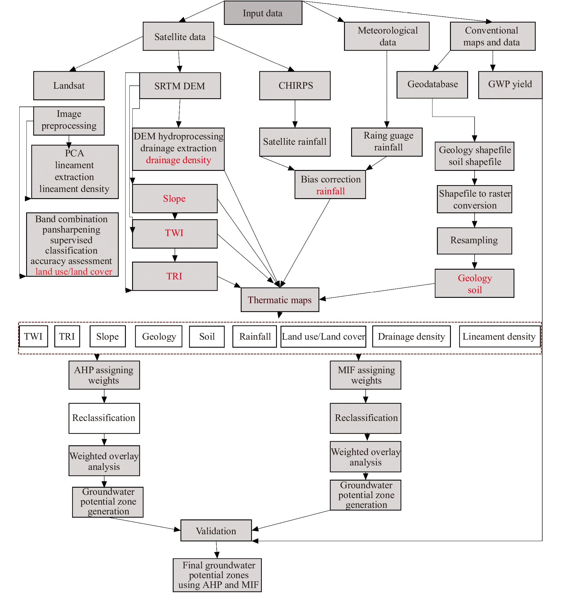
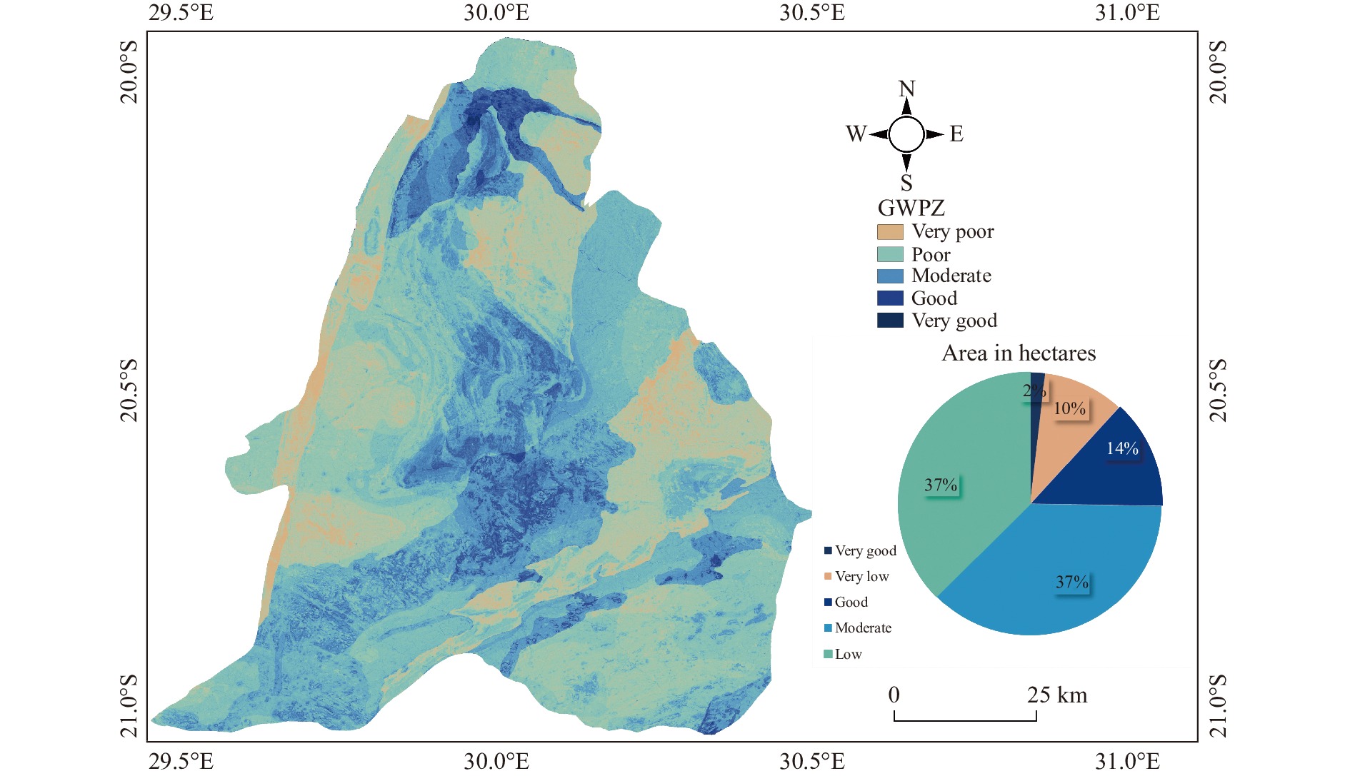
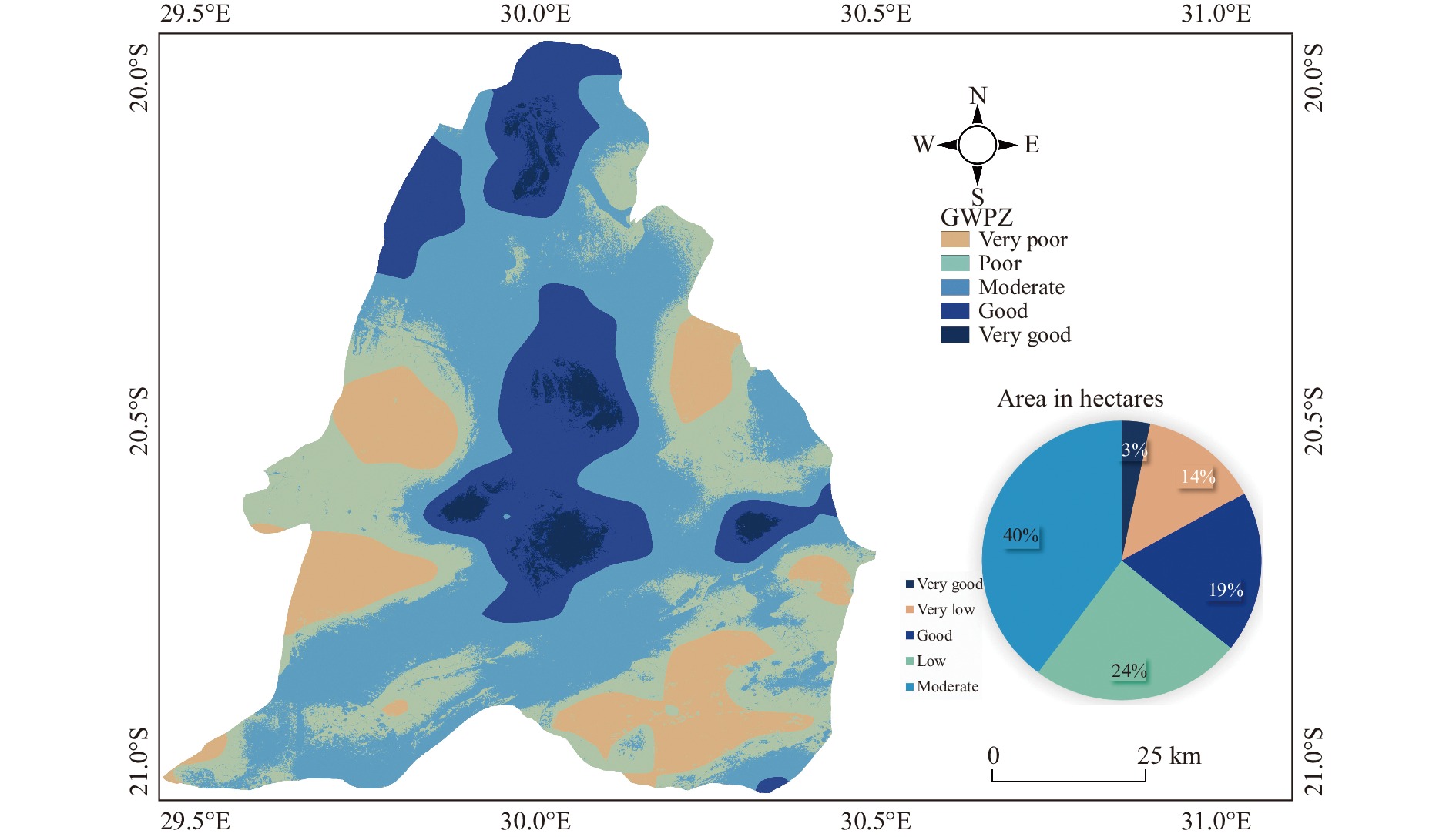
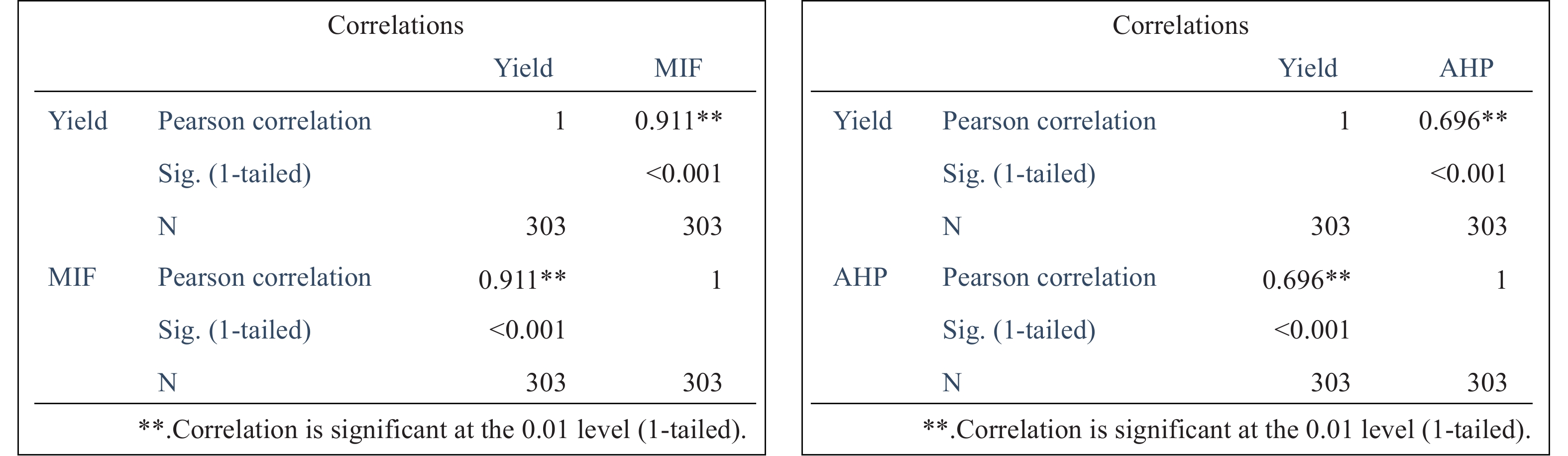
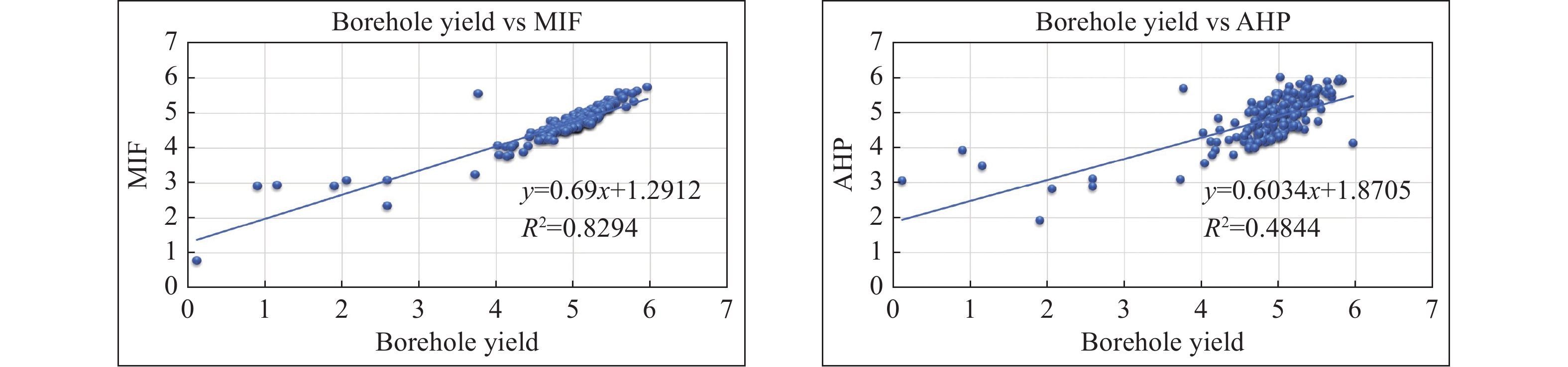
Abstract: The main objective of the study was to delineate Ground Water Potential Zones (GWPZ) in Mberengwa and Zvishavane districts, Zimbabwe, utilizing geospatial technologies and thematic mapping. Various factors, including geology, soil, rainfall, land use/land cover, drainage density, lineament density, slope, Terrain Ruggedness Index (TRI), and Terrain Wetness Index (TWI), were incorporated as thematic layers. The Multi Influencing Factor (MIF) and Analytical Hierarchical Process (AHP) techniques were employed to assign appropriate weights to these layers based on their relative significance, prioritizing GWPZ mapping. The integration of these weighted layers resulted in the generation of five GWPZ classes: Very high, high, moderate, low, and very low. The MIF method identified 3% of the area as having very high GWPZ, 19% as having high GWPZ, 40% as having moderate GWPZ, 24% as having low GWPZ, and 14% as having very low GWPZ. The AHP method yielded 2% for very high GWPZ, 14% for high GWPZ, 37% for moderate GWPZ, 37% for low GWPZ, and 10% for very low GWPZ. A strong correlation (ρ of 0.91) was observed between the MIF results and groundwater yield. The study successfully identified regions with abundant groundwater, providing valuable target areas for groundwater exploitation and high-volume water harvesting initiatives. Accurate identification of these crucial regions is essential for effective decision-making, planning, and management of groundwater resources to alleviate water shortages.
-
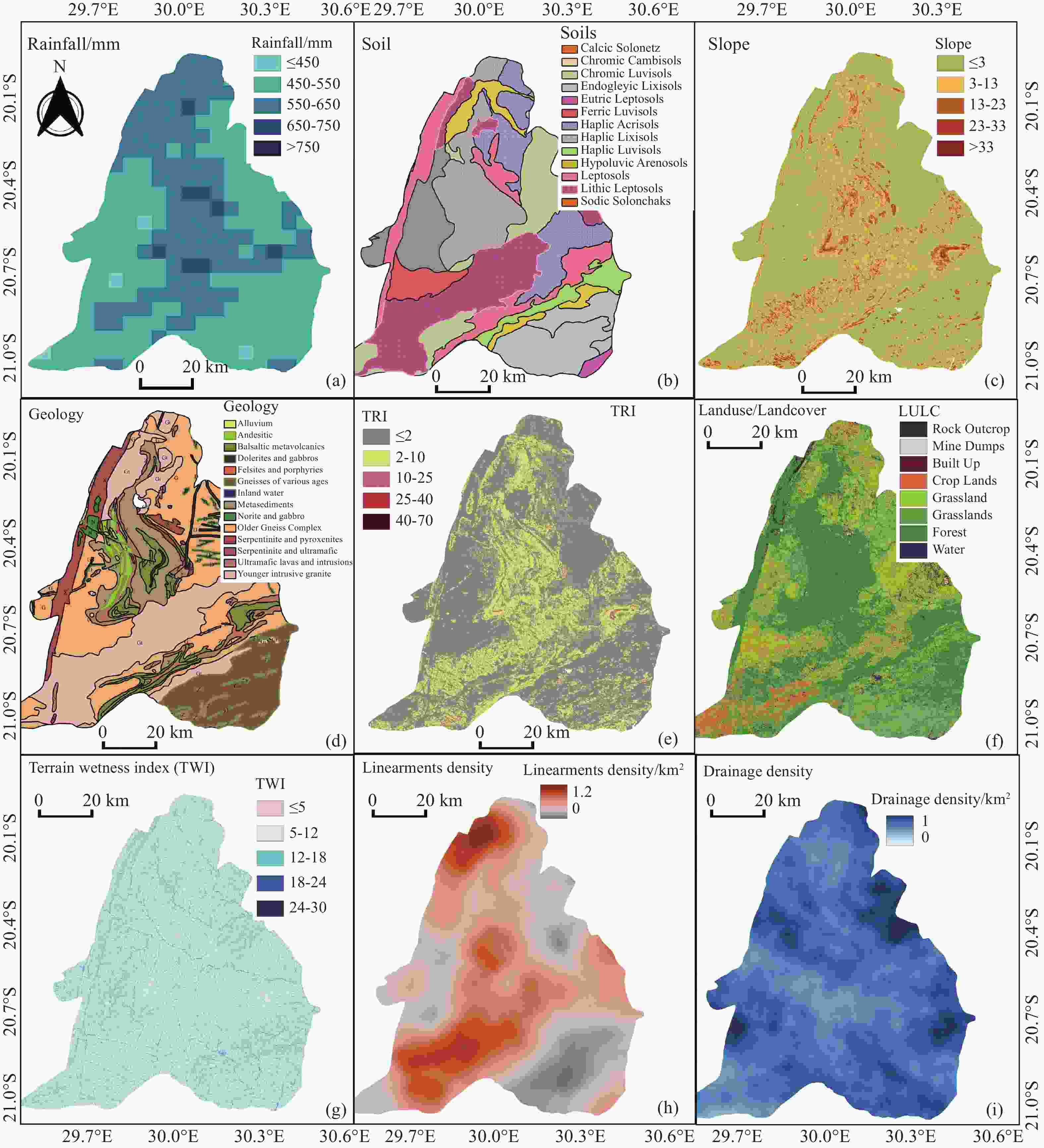
Figure 5. Conditioning factors in groundwater potential mapping a) Rainfall, b) Soil, c) Slope d) Geology, e) Terrain Ruggedness Index (TRI), f) Land use/Land cover (LULC), g) Terrain Wetness Index (TWI), h) Lineament Density, i) Drainage Density
Table 1. Data collected, source and use
Data Source Use SRTM DEM USGS For slope, TWI, TRI, Drainage density maps Landsat 8 path 170 and row 74 USGS For LULC classification and lineament extraction Soil Local geodatabase Soil classification Rainfall Metrological services department and CHIRPS rainfall data Rainfall map Geology Geomaps Rock type classification, lineaments  下载: 导出CSV
Table 2. Determine the weight of conditioning factors using AHP method.
Theme Normalized
theme weightFeature class Class weight Normalized theme weight (xi) Geology 0.165 Alluvium
Andesitic and dactic metavolcanic
Basaltic metavolcanic
Dolerites and gabbros
Felsites and porphyries
Gneiss of various ages
Metasediments
Norite and gabro
Older gneiss complex
Serpentinites
Ultramafic lavas
Young intrusive granites9
2
3
3
2
3
6
2
4
3
4
10.214
0.048
0.071
0.071
0.048
0.071
0.143
0.046
0.095
0.071
0.095
0.024Rainfall 0.146 <450
450–550
550–650
650–750
>7502
3
4
5
60.100
0.150
0.200
0.250
0.300Lineament density
/km/km20.128 0–0.3
0.3–0.6
0.6–0.9
0.9–1.2
>1.22
3
5
7
90.077
0.115
0.192
0.269
0.346Drainage density
/km/km20.092 0–0.3
0.3–0.6
0.6–0.9
0.9–1.2
>1.29
7
5
3
20.346
0.269
0.192
0.115
0.077Slope/o 0.110 0–5
5–10
10–15
15–20
>209
7
5
3
20.292
0.250
0.208
0.167
0.083TWI 0.102 0–6
6–12
12–18
18–24
24–302
4
5
7
80.077
0.154
0.192
0.269
0.308Soil 0.092 Arenosols
Leptosols
Luvisols
Acrisol
Solonchaks
Lixisols9
7
6
2
5
40.273
0.212
0.182
0.061
0.152
0.121LULC 0.110 Water
Forest
Shrubs and grassland
Agricultural fields
Bare land
Built up
Mine dumps
Rock outcrops9
7
6
5
4
2
2
10.257
0.200
0.171
0.143
0.086
0.057
0.057
0.029TRI 0.055 0–2
2–10
10–25
25–40
>407
6
5
3
10.300
0.250
0.200
0.150
0.100
下载: 导出CSV
Table 3. Determine the weight of conditioning factors using MIF method.
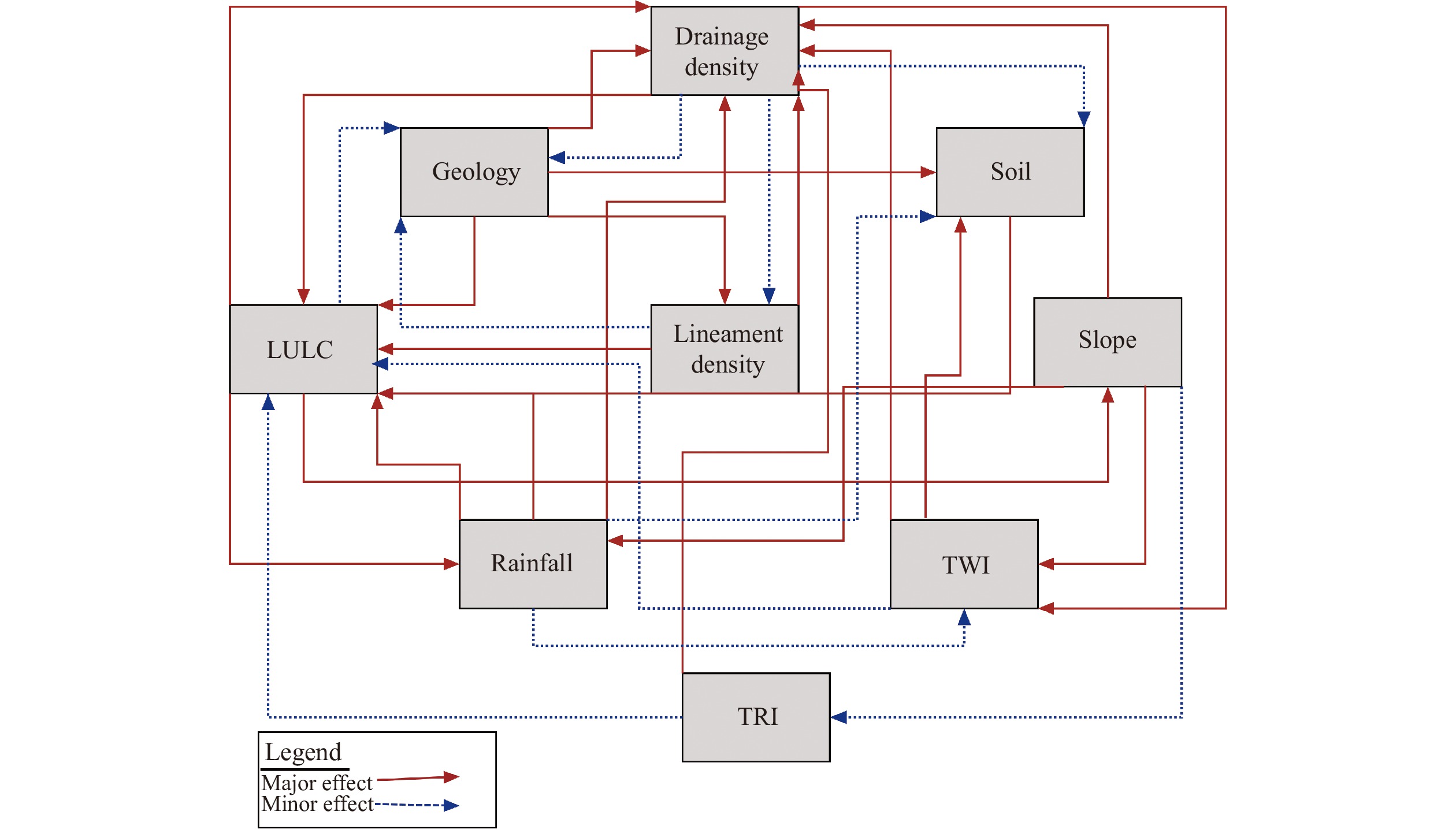
Factor Major effects (A) Minor effect(B) Proposed relative rates (A+B) Proposed score of each influencing factor (A+B) *100/∑(A+B) Lineaments density 1+1 0.5 2.5 9.80 Drainage density 1+1 0.5+0.5+0.5 3.5 13.73 Land use/Land cover 1+1+1 0.5 3.5 13.73 Geology 1+1+1+1 4 15.69 Soil 1 1 3.92 Rainfall 1+1 0.5+0.5 3 11.76 Slope 1+1+1 0.5+0.5 4 15.69 TWI 1+1 0.5 2.5 9.80 TRI 1 0.5 1.5 5.88 ∑25.5 100
下载: 导出CSV
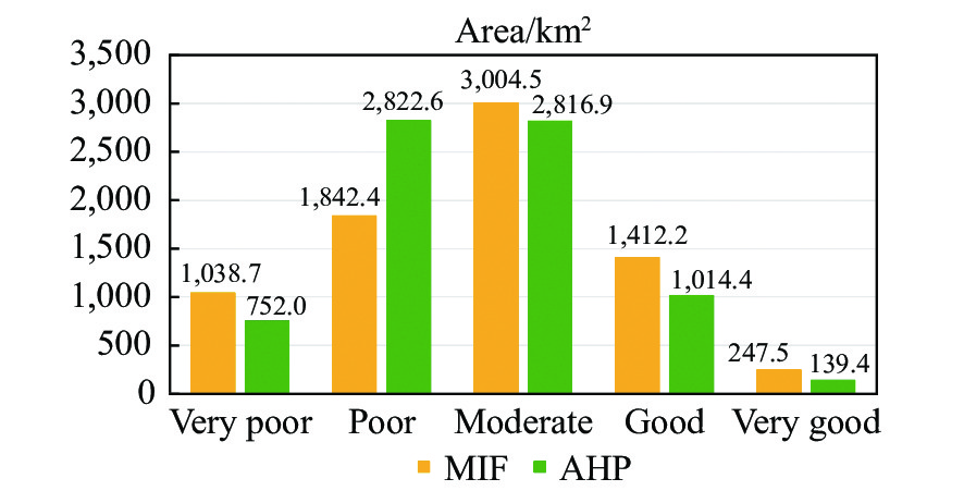
Table 4. The percentage and area covered by Ground Water Potential Zones (GWPZ)
Classification AHP area /Ha AHP area /% MIF area /Ha MIF area /% Very good 13,942 2 24,748 3 Good 101,436 14 141,217 19 Moderate 281,693 37 300,451 40 Low 282,259 37 184,238 24 Very low 75,195 10 103,871 14
下载: 导出CSV
-
Adeyeye OA, Ikpokonte EA, Arabi SA. 2019. GIS-based groundwater potential mapping within Dengi area, North Central Nigeria. The Egyptian Journal of Remote Sensing and Space Science, 22(2): 175-181. Ahmadi H, Pekkan E. 2021. Fault-based geological lineaments extraction using Remote Sensing and GIS—A review. Geosciences, 11(5): 183. DOI: 10.3390/geosciences11050183. Al-Nahmi F, Alami OB, Baidder L, et al. 2016. Using remote sensing for lineament extraction in Al MaghrAbah area–Hajjah, Yemen. The International Archives of the Photogrammetry, Remote Sensing and Spatial Information Sciences, XLII-2/W1: 137–142. Akbari M, Meshram SG, Krishna RS, et al. 2021. Identification of the groundwater potential recharge zones using MCDM Models: Full Consistency Method (FUCOM), Best Worst Method (BWM) and Analytic Hierarchy Process (AHP). Water Resources Management, 35(14): 4727–4745. Chaudhary BS, Kumar S. 2018. Identification of groundwater potential zones using Remote Sensing and GIS of K-J Watershed, India. Journal of the Geological Society of India, 91(6): 717−721. DOI: 10.1007/s12594-018-0929-3. Das B, Pal SC, Malik S, et al. 2019. Modeling groundwater potential zones of Puruliya district, West Bengal, India using remote sensing and GIS techniques. Geology, Ecology, and Landscapes, 3(3): 223-237. Das S. 2017. Delineation of groundwater potential zone in hard rock terrain in Gangajalghati block, Bankura district, India using remote sensing and GIS techniques. Modeling Earth Systems and Environment, 3(4): 1589–1599. Doke A. 2019. Delineation of the groundwater potential using remote sensing and GIS: A case study of Ulhas Basin, Maharashtra, India. Archives of Photogrammetry, Cartography and Remote Sensing, 31(1): 49−64. DOI: 10.2478/apcrs-2019-0004. Einlo F, Ekhtesasi MR, Ghorbani M, et al. 2023. Determine the most appropriate strategy for groundwater management in arid and semi-arid regions, Abhar Plain, Iran. Journal of Groundwater Science and Engineering, 11(2): 97−115. DOI: 10.26599/JGSE.2023.9280010. Emami H, Shahamat A. 2022. Geospatial groundwater potential zone mapping using geological, remote sensing data and multi criteria analysis techniques. Earth Observation and Geomatics Engineering, 6(1): 43−57. DOI: 10.22059/EOGE.2022.344474.1116. Gnanachandrasamy G, Zhou Y, Bagyaraj M, et al. 2018. Remote sensing and GIS based groundwater potential zone mapping in Ariyalur District, Tamil Nadu. Journal of the Geological Society of India, 92(4): 484-490. Goshime DW, Absi R, Haile AT, et al. 2020. Bias-corrected CHIRP satellite rainfall for water level simulation, Lake Ziway, Ethiopia. Journal of Hydrologic Engineering, 25(9): 05020024. Gumindoga W, Rientjes THM, Haile AT, et al. 2016. Bias correction schemes for CMORPH satellite rainfall estimates in the Zambezi River Basin. Hydrology and Earth System Sciences Discussions, 1−36. Hanane T, Ahmed A, Abdellah A. 2023. Groundwater potentiality mapping using machine learning algorithms BouSbaa area, Marrakech, Morocco. In Review. Research Square, 1-21. Hutti B, Nijagunappa R. 2011. Identification of groundwater potential zone using Geoinformatics in Ghataprabha Basin, North Karnataka, India. International Journal of Geomatics and Geosciences, 2(1): 91-109. Kabeto J, Adeba D, Regasa MS, et al. 2022. Groundwater potential assessment using GIS and Remote Sensing Techniques: Case study of West Arsi Zone, Ethiopia. Water, 14(12): 1838. DOI: 10.3390/w14121838. Karimi-Rizvandi S, Goodarzi HV, Afkoueieh JH, et al. 2021. Groundwater-potential mapping using a self-learning bayesian network model: A comparison among metaheuristic algorithms. Water, 13(5): 658. DOI: 10.3390/w13050658. Kazerani P, Ziaei AN, Davari K. 2023. Determining safe yield and mapping water level zoning in groundwater resources of the Neishabour Plain. Journal of Groundwater Science and Engineering, 11(1): 47−54. DOI: 10.26599/JGSE.2023.9280005. Kumar P, Herath S, Avtar R, et al. 2016. Mapping of groundwater potential zones in Killinochi area, Sri Lanka, using GIS and remote sensing techniques. Sustainable Water Resources Management, 2(4): 419−430. DOI: 10.1007/s40899-016-0072-5. Kumar YY, Moorthy DVS, Srinivas GS. 2017. Identification of groundwater potential zones using Remote Sensing and Geographical information System. International Journal of Civil Engineering and Technology, 8(3): 01−10. Magesh NS, Chandrasekar N, Soundranayagam JP. 2012. Delineation of groundwater potential zones in Theni district, Tamil Nadu, using remote sensing, GIS and MIF techniques. Geoscience Frontiers, 3(2): 189-196. Mallick J, Singh CK, AlMesfer MK, et al. 2021. Groundwater quality studies in the Kingdom of Saudi Arabia: Prevalent research and management dimensions. Water, 13(9): 1266. DOI: 10.3390/w13091266. Manap MA, Sulaiman WNA, Ramli MF, et al. 2013. A knowledge-driven GIS modeling technique for groundwater potential mapping at the Upper Langat Basin, Malaysia. Arabian Journal of Geosciences, 6(5): 1621−1637. DOI: 10.1007/s12517-011-0469-2. Masroor M, Sajjad H, Kumar P, et al. 2023. Novel ensemble machine learning modeling approach for groundwater potential mapping in Parbhani District of Maharashtra, India. Water, 15(3): 419. DOI: 10.3390/w15030419. Mathew TG, Ariffin KS. 2018. Remote sensing technique for lineament extraction in association with mineralization pattern in Central Belt Peninsular Malaysia. Journal of Physics: Conference Series, 1082: 012092. DOI: 10.1088/1742-6596/1082/1/012092. Melese T, Belay T. 2022. Groundwater potential zone mapping using Analytical Hierarchy Process and GIS in Muga Watershed, Abay Basin, Ethiopia. Global Challenges, 6(1): 2100068. DOI: 10.1002/gch2.202100068. Moore ID, Gessler PE, Neilsen GA, et al. 1993. Soil attribute predicted using terrain analysis. Soil Science Society of America Journal, 57: 443-452. Mukherjee S, Joshi PK, Mukherjee S, et al. 2013. Evaluation of vertical accuracy of open source Digital Elevation Model (DEM). International Journal of Applied Earth Observation and Geoinformation, 21: 205−217. DOI: 10.1016/j.jag.2012.09.004. Murugesan V, Krishnaraj S, Kannusamy V, et al. 2011. Groundwater potential zoning in Thirumanimuttar sub-basin Tamilnadu, India-A GIS and remote sensing approach. Geo-Spatial Information Science, 14(1): 17−26. DOI: 10.1007/s11806-011-0422-2. Muthamilselvan A, Anamika S, Emmanuel I. 2022. Identification of groundwater potential in hard rock aquifer systems using Remote Sensing, GIS and Magnetic Survey in Veppanthattai, Peram-balur, Tamilnadu. Journal of Groundwater Science and Engineering, 10(4): 367−380. DOI: 10.19637/j.cnki.2305-7068.2022.04.005. Osinowo OO, Arowoogun KI. 2020. A multi-criteria decision analysis for groundwater potential evaluation in parts of Ibadan, southwestern Nigeria. Applied Water Science, 10(11): 228. DOI: 10.1007/s13201-020-01311-2. Oyedele AA. 2019. Use of remote sensing and GIS techniques for groundwater exploration in the basement complex terrain of Ado-Ekiti, SW Nigeria. Applied Water Science, 9(3): 1-13. Prasad P, Loveson VJ, Kotha M, et al. 2020. Application of machine learning techniques in groundwater potential mapping along the west coast of India. GIScience & Remote Sensing, 57(6): 735−752. DOI: 10.1080/15481603.2020.1794104. Raju BA, Rao PV, Subrahmanyam M. 2023. Estimating aquifer transmissivity using Dar-Zarrouk parameters to delineate groundwater potential zones in Alluri Seetharama Raju District, Andhra Pradesh, India. Journal of Groundwater Science and Engineering, 11(2): 116−132. DOI: 10.26599/JGSE.2023.9280011. Różycka M, Migoń P, Michniewicz A. 2017. Topographic wetness index and terrain ruggedness index in geomorphic characterisation of landslide terrains, on examples from the Sudetes, SW Poland. Zeitschrift Für Geomorphologie, Supplementary Issues, 61(2): 61-80. Salimi AH, Masoompour Samakosh J, Sharifi E, et al. 2019. Optimized artificial neural networks-based methods for statistical downscaling of gridded precipitation data. Water, 11(8): 1653. DOI: 10.3390/w11081653. Sarkar SK, Talukdar S, Rahman AS, et al. 2022. Groundwater potentiality mapping using ensemble machine learning algorithms for sustainable groundwater management. Frontiers in Engineering and Built Environment, 2(1): 43−54. DOI: 10.1108/FEBE-09-2021-0044. Senapati U, Das TK. 2022. GIS-based comparative assessment of groundwater potential zone using MIF and AHP techniques in Cooch Behar district, West Bengal. Applied Water Science, 12(3): 43. DOI: 10.1007/s13201-021-01509-y. Sohail AT, Singh SK, Kanga S. 2019. A geospatial approach for groundwater potential assessment using Multi Influence Factor (MIF) technique. International Journal on Emerging Technologies, 10(1): 183−196. Sutradhar S, Mondal P, Das N. 2021. Delineation of groundwater potential zones using MIF and AHP models: A micro-level study on Suri Sadar Sub-Division, Birbhum District, West Bengal, India. Groundwater for Sustainable Development, 12: 100547. DOI: 10.1016/j.gsd.2021.100547. Thapa R, Gupta S, Guin S, et al. 2017. Assessment of groundwater potential zones using multi-influencing factor (MIF) and GIS: A case study from Birbhum district, West Bengal. Applied Water Science, 7(7): 4117−4131. DOI: 10.1007/s13201-017-0571-z. Yadav S, Salui CL. 2021. Artificial neural network for identification of groundwater potential zones in part of Hugli District, West Bengal, India. In Shit PK, Bhunia GS, Adhikary PP, (Eds. ), Groundwater and Society, 247–257. Springer International Publishing. Yang L, Zhang YP, Wen XR, et al. 2020. Characteristics of groundwater and urban emergency water sources optimazation in Luoyang, China. Journal of Groundwater Science and Engineering, 8(3): 298−304. DOI: 10.19637/j.cnki.2305-7068.2020.03.010. Yeh HF, Cheng YS, Lin HI, et al. 2016. Mapping groundwater recharge potential zone using a GIS approach in Hualian River, Taiwan. Sustainable Environment Research, 26(1): 33−43. DOI: 10.1016/j.serj.2015.09.005. Zghibi A, Mirchi A, Msaddek MH, et al. 2020. Using analytical hierarchy process and multi-influencing factors to map groundwater recharge zones in a semi-arid Mediterranean Coastal Aquifer. Water, 12(9): 2525. DOI: 10.3390/w12092525. Zhang K, Gann D, Ross M, et al. 2019. Accuracy assessment of ASTER, SRTM, ALOS, and TDX DEMs for hispaniola and implications for mapping vulnerability to coastal flooding. Remote Sensing of Environment, 225: 290−306. DOI: 10.1016/j.rse.2019.02.028. ZIMSTAT. 2022. Population and Housing Census. https://www.zimstat.co.zw/wp-content/uploads/2022/07/Census2022_Preliminary_Report.pdf Zeinolabedini M, Esmaeily A. 2015. Groundwater potential assessment using Geographic Information Systems and AHP method (Case study: Baft City, Kerman, Iran). The International Archives of the Photogrammetry, Remote Sensing and Spatial Information Sciences, XL-1/W5: 769–774. -


 点击查看大图

计量
- 文章访问数: 5336
- HTML全文浏览量: 2537
- PDF下载量: 295
- 被引次数: 0


