 E-mail alert
 Rss
Rss

Electrical geophysical evaluation of susceptibility to flooding in University of Nigeria, Nsukka main campus and its environs, Southeastern Nigeria
-
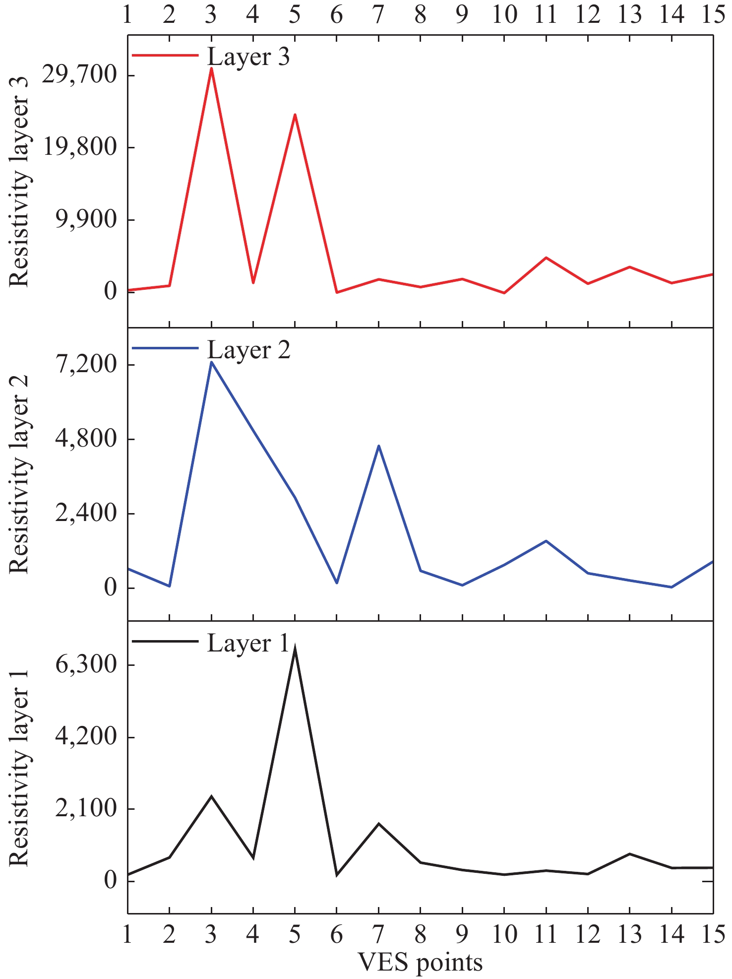
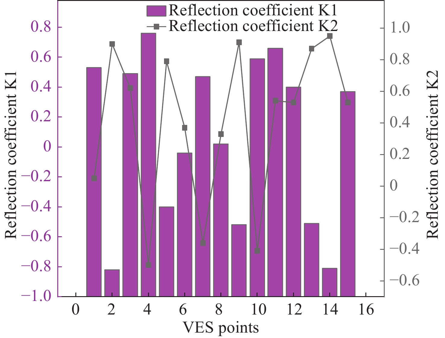
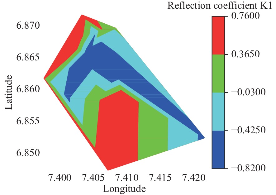
Abstract: Flooding occurs when rainfall exceeds the absorption capacity of soil and causes significant environmental consequences. In this study, electrical resistivity techniques were employed to assess the flood susceptibility of the study area by examining variations in electrical properties. Prior to flooding, Vertical Electrical Sounding (VES) and Electrical Resistivity Tomography (ERT) profiles were conducted to determine the variations in resistivity within subsurface lithologies exposed to the injected current. The injected current penetrated the subsurface units characterised by resistivity ranging from 190.5 Ω·m to 6,775.7 Ω·m, 42.3 Ω·m to 7,297.4 Ω·m, and 320.2 Ω·m to 24,433.3 Ω·m in the first, second and third layers, respectively. These layers were identified as lateritic topsoil, medium-coarse brownish grained sand, and coarse pebbly blackish sand, respectively. The calculated reflection coefficients between layers 1, 2, and 3 reveal alternation in layers with values ranging from −0.04 to 0.66 and 0.36 to 0.95 for
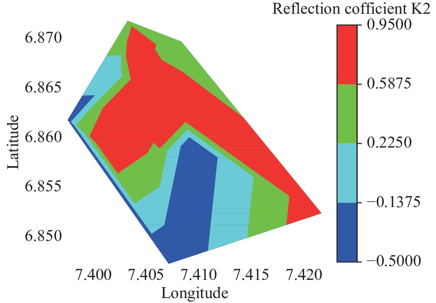
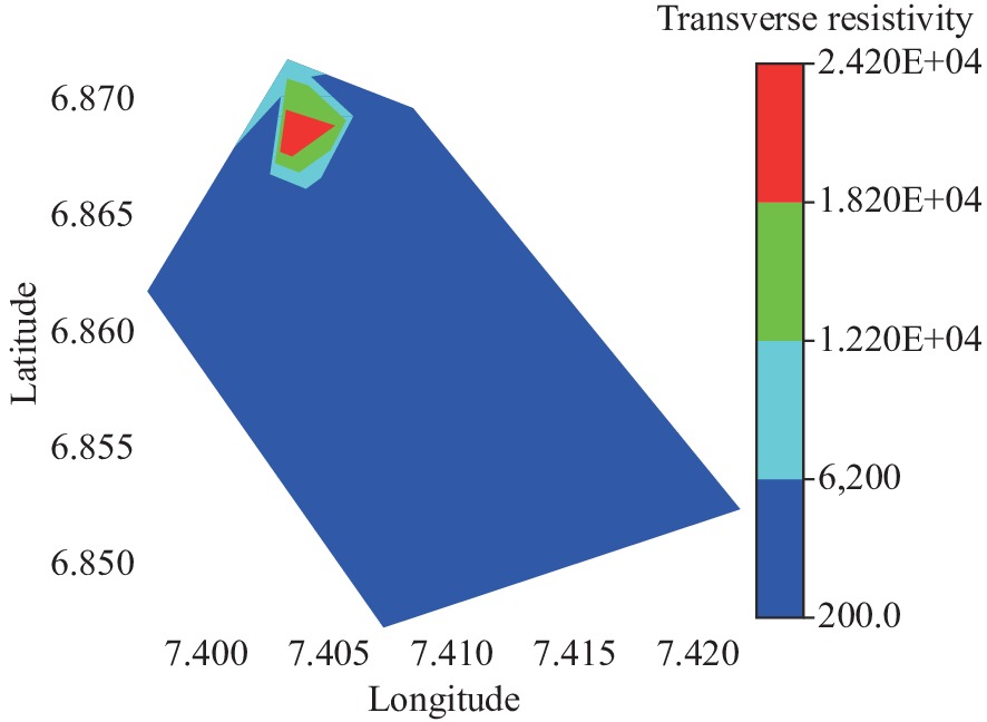
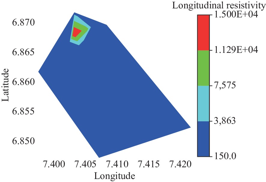
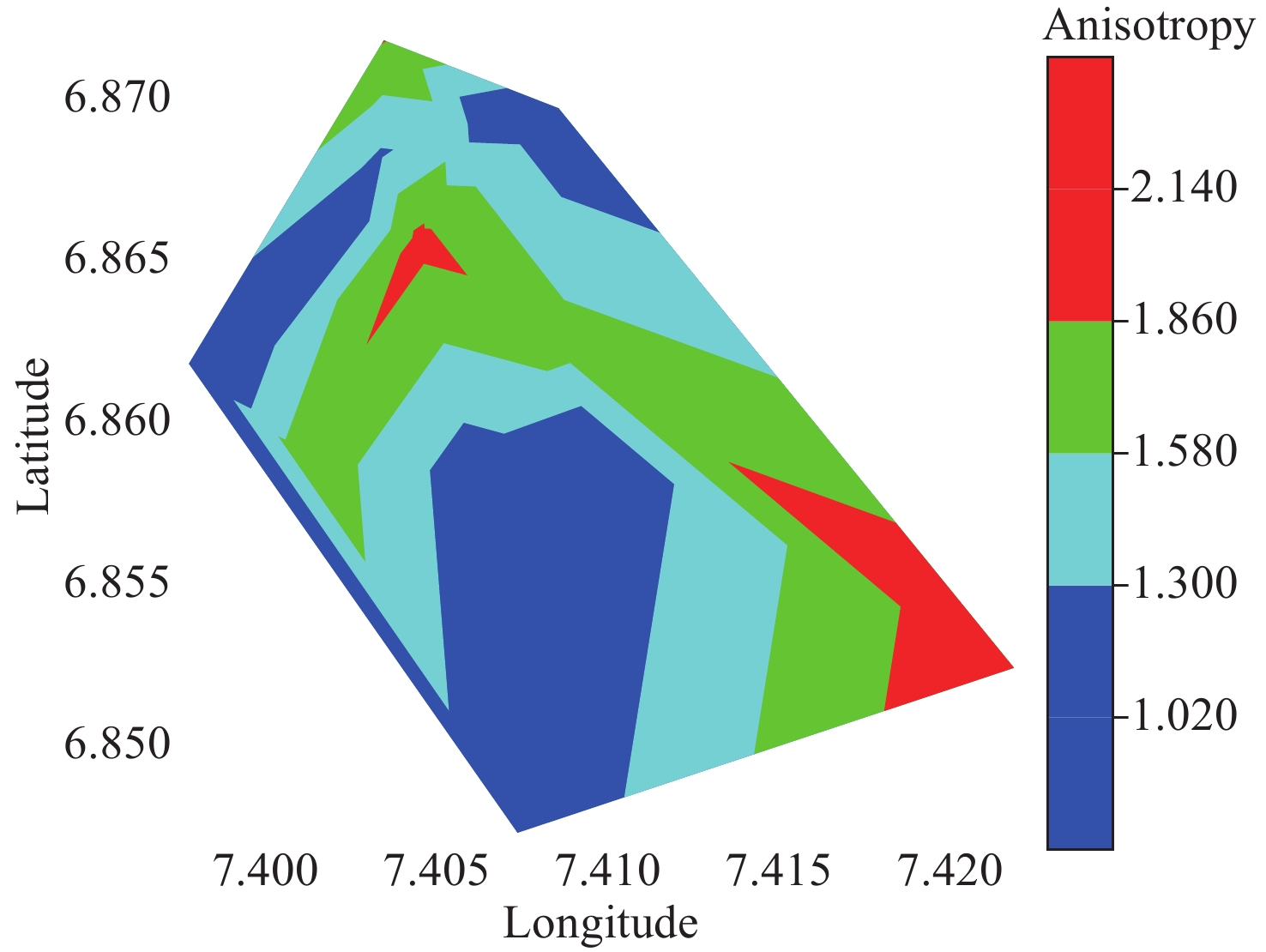
$ {k}_{1} $ and$ {k}_{2} $ , respectively. The transverse resistivity, longitudinal resistivity and anisotropy ranged from 243.59 Ω·m to 24,115.42 Ω·m, 199.61 Ω·m to 14,950.76 Ω·m, and 1.02 to 2.14. Models derived from the ERT profiles reveal variations in resistivity, pinpointing areas of low resistivity which correspond to waterlogged and impermeable layers. The result of this study underscores the importance of integrated resistivity techniques in the study of floods, as it provides valuable insights into flood behaviour, and subsurface dynamics. -

Figure 1. Examples of flood affected areas: (a, b and c) part of the University stadium predisposed to flooding during rainy season, (d) front of the University Secondary School during rainy season.
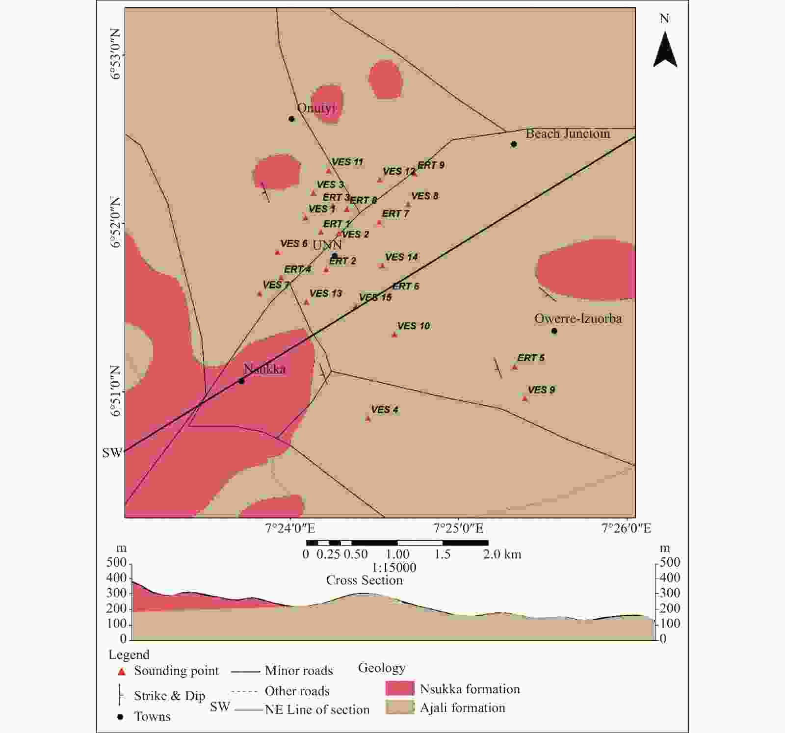
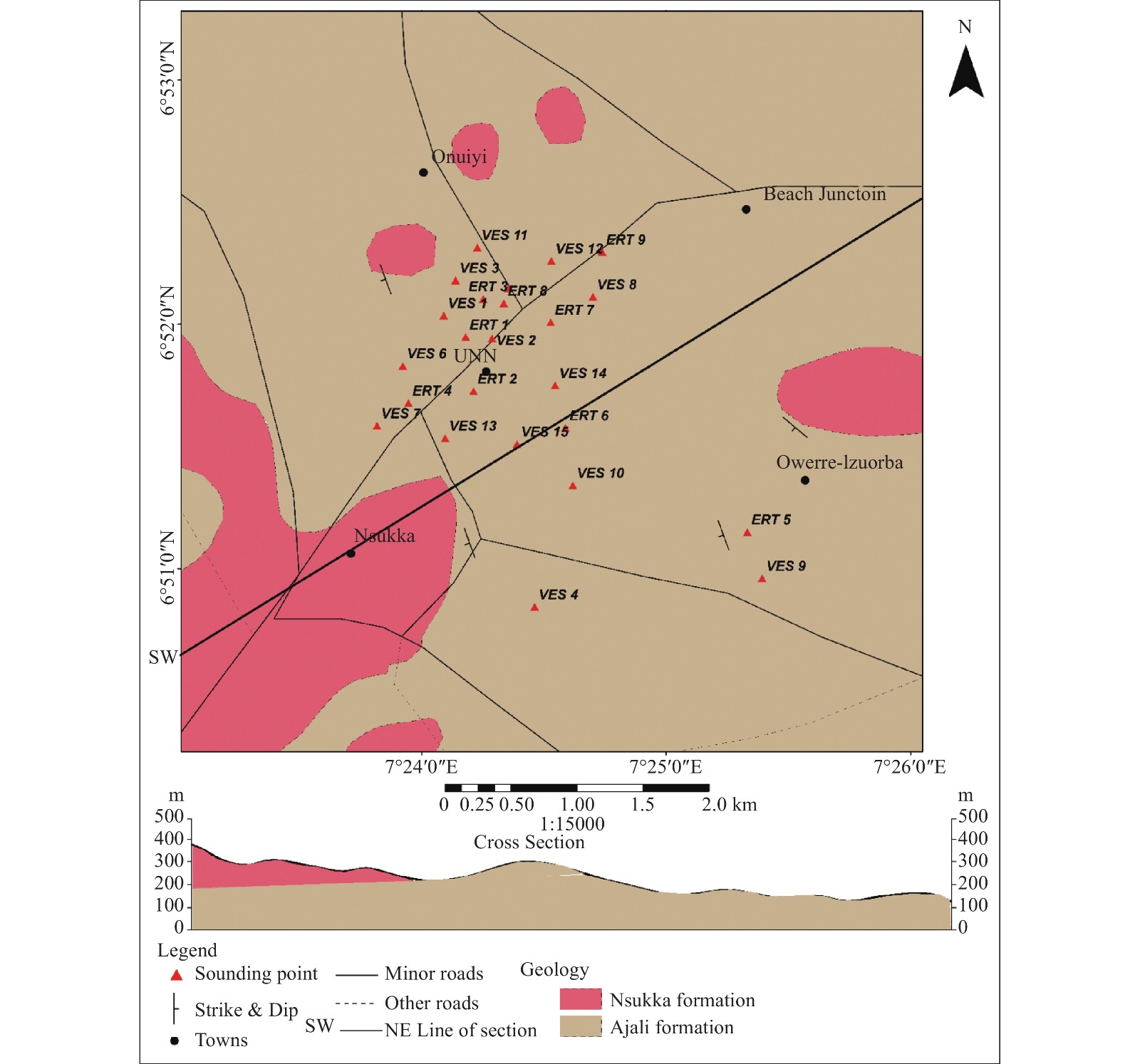
Figure 2. Geologic map of the area showing the location of the study area and the geological cross section along the line trending SW – NE.

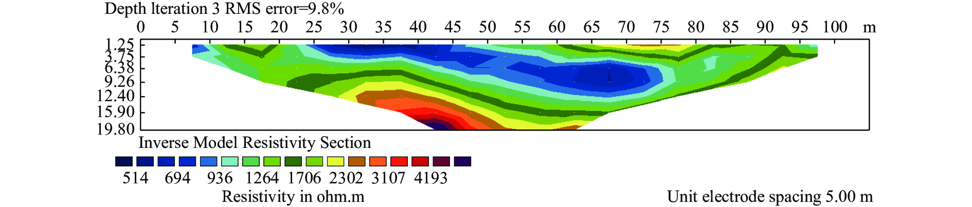
Figure 11. 2D electrical resistivity tomography model of the study area along profile 1

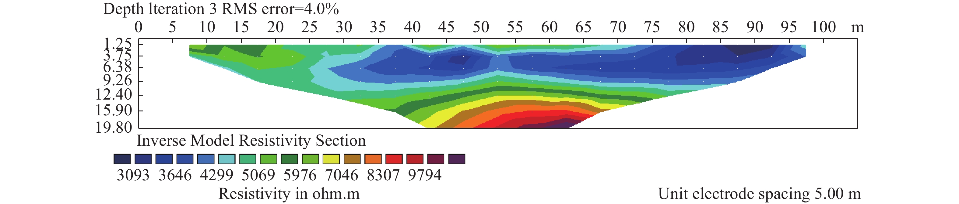
Figure 12. 2D electrical resistivity tomography model of the study area along profile 2
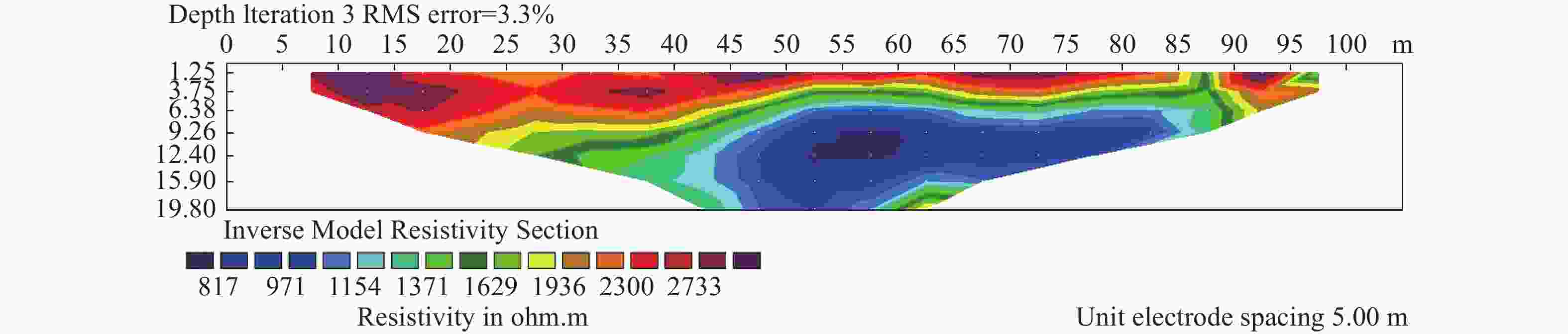
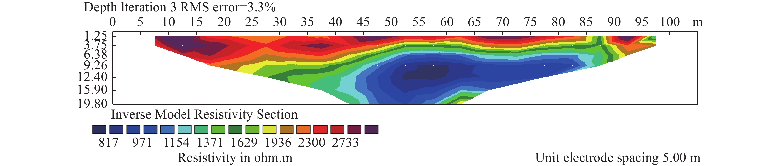
Figure 13. 2D electrical resistivity tomography model of the study area along profile 3
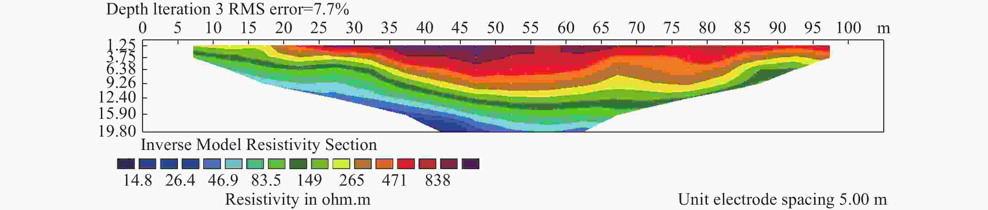
Figure 14. 2D electrical resistivity tomography model of the study area along profile 4
Table 1. Summary of measured electrical resistivity data in the study area
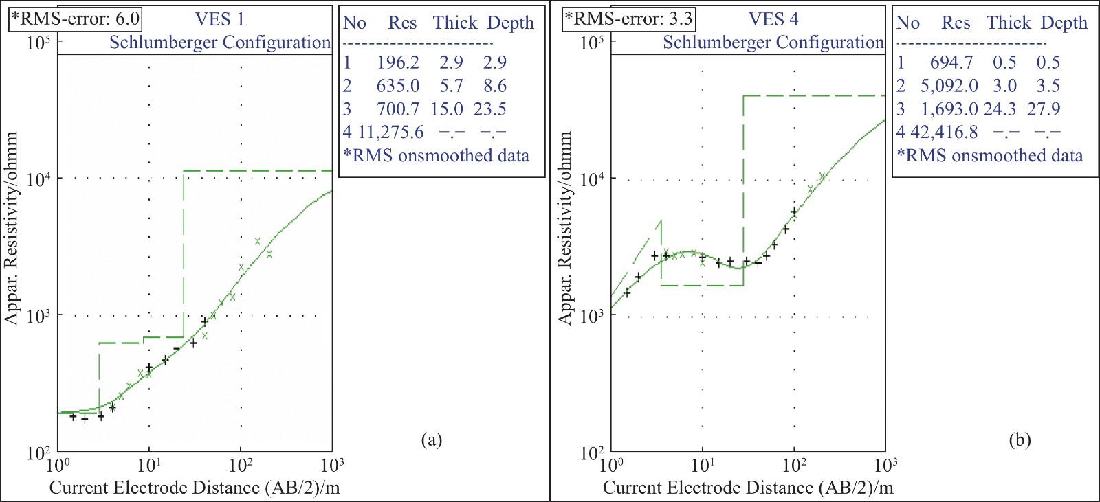
VES Longitude/°E Latitude/°N Layer Resistivity/Ω·m Thickness/m Depth/m Elevation/m $ {\mathrm{\rho }}_{1} $ $ {\mathrm{\rho }}_{2} $ $ {\mathrm{\rho }}_{3} $ $ {\mathrm{\rho }}_{4} $ $ {\mathrm{h}}_{1} $ $ {\mathrm{h}}_{2} $ $ {\mathrm{h}}_{3} $ $ {\mathrm{d}}_{1} $ $ {\mathrm{d}}_{2} $ $ {\mathrm{d}}_{3} $ 1 7.4029 6.8665 196.2 635.0 700.7 11,275.6 2.9 5.7 15.0 2.9 8.6 23.5 447 2 7.4048 6.8657 695.2 71.0 1,300.3 70,816.5 3.6 3.8 5.1 3.6 7.4 12.5 457 3 7.4037 6.8684 2,474.6 7,297.4 30,696.3 3,531.4 0.5 6.4 18.0 0.5 6.9 24.9 447 4 7.4077 6.8474 694.7 5,092.0 1,693.0 42,416.8 0.5 3.0 24.3 0.5 3.5 27.9 453 5 7.4059 6.8691 6,775.7 2,926.9 24,433.3 6,221.5 6.8 11.1 35.2 6.8 17.9 53.1 446 6 7.3991 6.8613 190.5 174.3 381.4 89,226.5 2.0 10.4 6.0 2.0 12.4 18.5 440 7 7.3981 6.8619 1,681.2 4,597.3 2,166.2 864.3 0.9 3.1 35.4 0.9 4.0 39.4 440 8 7.4089 6.8698 547.4 870.6 1,125.9 1,322.4 3.2 7.4 15.8 2.2 10.6 26.4 414 9 7.4222 6.8525 331.6 103.5 2,212.0 2,398.0 2.8 4.6 7.1 2.8 7.4 14.5 475 10 7.4098 6.8596 196.6 760.9 320.2 3,617.1 0.7 7.1 14.2 0.7 7.8 22.1 454 11 7.4038 6.8719 314..7 1,532.9 5,083.7 198.2 1.3 21.9 40.9 1.3 23.2 64.1 402 12 7.4067 6.8696 213.7 493.1 1,585.9 2,517.0 0.5 4.9 28.4 0.6 5.5 34.0 412 13 7.4016 6.8589 798.9 258.8 3,847.1 3,901.3 1.8 9.2 32.8 1.8 11.0 43.5 432 14 7.4091 6.8625 393.4 42.3 1,672.1 1,246.8 1.8 2.3 39.5 1.8 4.1 43.6 436 15 7.4065 6.8585 398.9 874.7 2,855.5 4,554.0 1.3 6.4 53.1 1.3 7.7 60.8 442  下载: 导出CSV
Table 2. Summary of estimated hydrogeologic parameter
VES
pointsLong.
/°ELat.
/°NReflection coefficient ρt
/Ω·mρl
/Ω·mλ $ {k}_{1} $ $ {k}_{2} $ 1 7.4029 6.8665 0.53 0.05 622.84 522.54 1.09 2 7.4048 6.8657 −0.82 0.90 752.32 199.61 1.94 3 7.4037 6.8684 0.49 0.62 24,115.42 14,950.76 1.27 4 7.4077 6.8474 0.76 −0.50 2041.84 1,774.98 1.07 5 7.4059 6.8691 −0.40 0.79 17,676.37 8,514.18 1.44 6 7.3991 6.8613 −0.04 0.37 243.59 214.21 1.07 7 7.3981 6.8619 0.47 −0.36 2,346.40 2,244.81 1.02 8 7.4089 6.8698 0.02 0.33 900.13 803.71 1.06 9 7.4222 6.8525 −0.52 0.91 1,179.99 258.48 2.14 10 7.4098 6.8596 0.59 −0.41 458.49 384.35 1.09 11 7.4038 6.8719 0.66 0.54 8,487.33 2,418.87 1.87 12 7.4067 6.8696 0.40 0.53 1,407.18 1,119.77 1.12 13 7.4016 6.8589 −0.51 0.87 2,968.13 945.44 1.77 14 7.4091 6.8625 −0.81 0.95 1,533.33 528.02 1.70 15 7.4065 6.8585 0.37 0.53 2,594.47 2,084.23 1.12
下载: 导出CSV
-
Adabanija MA, Oladunjoye MA. 2014. Investigating internal geometry of a Flood Plain in Basement Complex Terrain of South-western Nigeria using Electrical Resistance Tomography. International Journal of Multidisciplinary and Current Research, 2: 925−931. Adekalu KO, Olorunfemi IA, Osunbitan JA. 2007. Grass mulching effect on infiltration, surface runoff and soil loss of three agricultural soils in Nigeria. Bioresource Technology, 98(4): 912−917. DOI: 10.1016/j.biortech.2006.02.044. Agagu OK, Fayose EA, Petters, SW. 1985. Stratigraphy and sedimentation in the Senonian Anambra Basin of eastern Nigeria. Journal of Mining & Geology, 22(1): 26–36. Agbonkhese O, Agbonkhese EG, Aka EO, et al. 2014. Flood menace in Nigeria: Impacts, remedial and management strategies. Civil and Environmental Research, 6(4): 32–40. Aizebeokhai AP, Alile OM, Kayode JS, et al. 2010. Geophysical investigation of some Flood Prone areas in Ota, Southwestern Nigeria. American-Eurasian Journal of Scientific Research, 5 (4): 216-229. Ajibade FO, Ajibade TF, Idowu TE, et al. 2021. Flood-prone area mapping using GIS-based analytical hierarchy frameworks for Ibadan City, Nigeria. Journal of Multi-Criteria Decision Analysis, 28(5-6): 283−295. DOI: 10.1002/mcda.1759. Akpan AE, George NJ, George AM, 2009. Geophysical investigation of some prominent gully erosion sites in Calabar, southeastern Nigeria and its implications to hazard prevention. Disaster Advances, 2(3): 46-50. Bala M, Cichy A. 2015. Evaluating electrical anisotropy parameters in miocene formations in the cierpisz deposit. Acta Geophysica, 63(5): 1296−1315. DOI: 10.2478/s11600-014-0252-3. Chikwelu E, Ogbuagu FU. 2014. Geotechnical investigation of soils around Mbaukwu Gully Erosion Sites South–Eastern part of Nigeria. Journal of Applied Geology and Geophysics, 2: 6 – 17. Dekongmen BW, Kabo-bah AT, Domfeh MK. et al. 2021. Flood vulnerability assessment in the Accra Metropolis, southeastern Ghana. Applied Water Science, 11: 134. Echendu AJ. 2021. Flooding in Nigeria and Ghana: Opportunities for partnerships in disaster-risk reduction. Sustainability: Science, Practice and Policy, 18(1): 1–15. Ekanem AM. 2020. Georesistivity modelling and appraisal of soil water retention capacity in Akwa Ibom State University main campus and its environs, Southern Nigeria. Modelling Earth System and Environment, 6: 2597-2608. El-Zein A, Ahmed T, Tonmoy F. 2021. Geophysical and social vulnerability to floods at municipal scale under climate change: The case of an inner-city suburb of Sydney. Ecological Indicators, 121 (2021): 106988. George NJ, Akpan AE, Akpan FS. 2017. Assessment of spatial distribution of porosity and aquifer geohydraulic parameters in parts of the tertiary-quaternary hydrogeoresource of south-eastern Nigeria. NRIAG Journal of Astronomy Geophysics, 6(2): 422–433. George NJ. 2020. Appraisal of hydraulic flow units and factors of the dynamics and contamination of hydrogeological units in the littoral zones: A case study of Akwa Ibom State University and its Environs, Mkpat Enin LGA, Nigeria. Natural Resources Research, 29: 3771-3788. George NJ, Ibuot JC, Ekanem AM, et al. 2018. Estimating the indices of inter- transmissibility magnitude of active surficial hydrogeologic units in Itu, Akwa Ibom State, Southern Nigeria. Arabian Journal of Geosciences, 11(6): 1–16. Henriet JP. 1976. Direct application of Dar-Zarrouk parameters in ground water surveys. Geophysical Prospecting, 24: 344–353. Hübner R, Heller K, Günther T, et al. 2015. Monitoring hillslope moisture dynamics with surface ERT for enhancing spatial significance of hydrometric point measurements. Hydrology and Earth System Sciences, 19: 225−240. DOI: 10.5194/hess-19-225-2015. Ibuot JC, Aka MU, Inyang NJ, et al. 2022. Georesistivity and physicochemical evaluation of hydrogeologic units in parts of Akwa Ibom State, Nigeria. International Journal of Energy and water Resources, 6. Ibuot JC, George NJ, Okwesili AN, et al. 2019. Investigation of litho-textural characteristics of aquifer in Nkanu west local government area of Enugu State, southeastern Nigeria. Journal of African Earth Scienece, 153: 197−207. DOI: 10.1016/j.jafrearsci.2019.03.004. Kayode JS, Arifin MH, Kamarudin MK, et al. 2019. The vulnerability of the aquifer units in the flood-affected areas of the east coast Peninsula Malaysia. Arabian Journal of Geosciences, 12: 146. Keller GV, Frischknecht FC. 1966. Electrical methods in geoelectric prospecting. Pergamon Press 90–04: 1966. Keller GV, Frischknecht FC. 1982. Electrical methods in geophysical prospecting. London: Pergamon Press. Vol 10. Kim J, Kang J. 2021. Analysis of food damage in the Seoul Metropolitan government using climate change scenarios and mitigation technologies. Sustainability, 13(105): 1–28. Koestel J, Vanderborght J, Javaux M, et al. 2009. Noninvasive 3-D transport characterization in a sandy soil using ERT: 1. Investigating the validity of ERT derived transport parameters. Vadose Zone Journal, 8: 711–722. Loke MH. 2000. Electrical imaging surveys for environmental and engineering studies: A practical guide to 2-D and 3-D surveys. 1-61. Lowrie W. 1997. Fundamentals of Geophysics. Cambridge University Press, New York, NY. Negese A, Worku D, Shitaye A, et al. 2022. Potential food-prone area identifcation and mapping using GIS-based multi-criteria decision-making and analytical hierarchy process in Dega Damot district, northwestern Ethiopia. Applied Water Science, 12: 255. Nigeria Hydrological Services Agency. 2020. 2020 annual flood outlook. Available online at: https://nihsa.gov.ng/wp-content/uploads/2020/06/2020-NIHSA-Annual-Flood-Outlook-AFO-5-2.pdf. Nutzmann G, Viotti P, Aagaard P. 2005. Reactive transport in soil and groundwater: Processes and models. Berlin, Germany: Springer−Verlag. Nwajide CS, Reijers TJ. 1996. The geology of the Southern Anambra Basin. In: Reijers, T. J. A. (Ed.), Selected Chapters on Geology: Sedimentary Geology and Sequence Stratigraphy of the Anambra Basin. SPDC, 133–148 Nwajide CS. 2013. Geology of Nigeria's Sedimentary Basins. CSS Bookshops, Lagos: 565. Obaje NG. 2009. Geology and mineral resources of Nigeria (221). Berlin: Springer. Obiora DN, Ibuot JC. 2020. Geophysical assessment of aquifer vulnerability and management: A case study of University of Nigeria, Nsukka, Enugu State. Applied Water Science, 10: 1−11. DOI: 10.1007/s13201-019-1113-7. Ogbukagu IN. 1976. Soil erosion in the northern part of Awka-Orlu uplands, Nigeria. Journal of Mining and Geology, 13(2): 6-19. Olasehinde PI, Bayewu CG. 2011. Evaluation of eiectrical resistivity anisotropy in geological mapping: A case study of Odo Ara, West Central Nigeria. African Journal of Environmental Science and Technology, 5(7): 553−565. Omeje ET, Obiora DN, Okeke FN, et al. 2023. Investigation of aquifer vulnerability and sensitivity analysis of modified drastic and sintacs models: A case study of Ovogovo Area, Eastern Nigeria. Acta Geophysica, 71: 2439-2464. Owusu AB, Agbozo M. 2019. Application of geographic information systems for food risk analysis: a case study from Accra Metropolitan Area. Present Environment and Sustainable Development, 13(1): 81–97. Osei BK, Ahenkorahb I, Ewusi A, et al. 2021. Assessment of flood prone zones in the Tarkwa mining area of Ghana using a GIS-based approach. Environmental Challenges, 3: 100028. Reyment RA. 1965. Aspect of the Geology of Nigeria Ibadan University Press. 133. Salvati A, Nia AM, Salajegheh A, et al. 2023. Flood susceptibility mapping using support vector regression and hyper-parameter optimization. Journal of Flood Risk Management, e12920. https://doi.org/10.1111/jfr3.12920 Shahabi H, Shirzadi A, Ghaderi K, et al. 2020. Flood detection and susceptibility mapping using Sentinel-1 remote sensing data and a machine learning approach: Hybrid intelligence of bagging ensemble based on Knearest neighbor classifier. Remote Sensing, 12(2): 266. DOI: 10.3390/rs12020266. Shailaja G, Laxminarayana M, Patil JD, et al. 2016. Efficacy of anisotropic properties in groundwater exploration from geoelectric sounding over trap covered terrain. The Jouornal of Indian Geophysical Union, 20(5): 453–461. Tehrany MS, Lee MJ, Pradhan B, et al. 2014. Flood susceptibility mapping using integrated bivariate and multivariate statistical models. Environ Earth Science, 72: 1–15. Telford WM, Geldart LP, Sheriff RE, et al. 1990. Applied Geophysics. Cambridge University Press, Cambridge. Umar N, Gray A. 2023. Flooding in Nigeria: A review of its occurrence and impacts and approaches to modelling flood data. International Journal of Environmental Studies, 80: 3, 540−561. Wu Z, Zhou Y, Wang H, et al. 2020. Depth prediction of urban food under diferent rainfall return periods based on deep learning and data warehouse. Science of the Total Environment, 716: 137077 Zohdy AAR, Eaton GP, Mabey DR. 1974. Application of surface geophysics to groundwater investigations. US Geological Survey Techniques of Water–Resources Investigations, Book 2: 116 (Chapter D1). -


 点击查看大图

计量
- 文章访问数: 1114
- HTML全文浏览量: 490
- PDF下载量: 128
- 被引次数: 0


