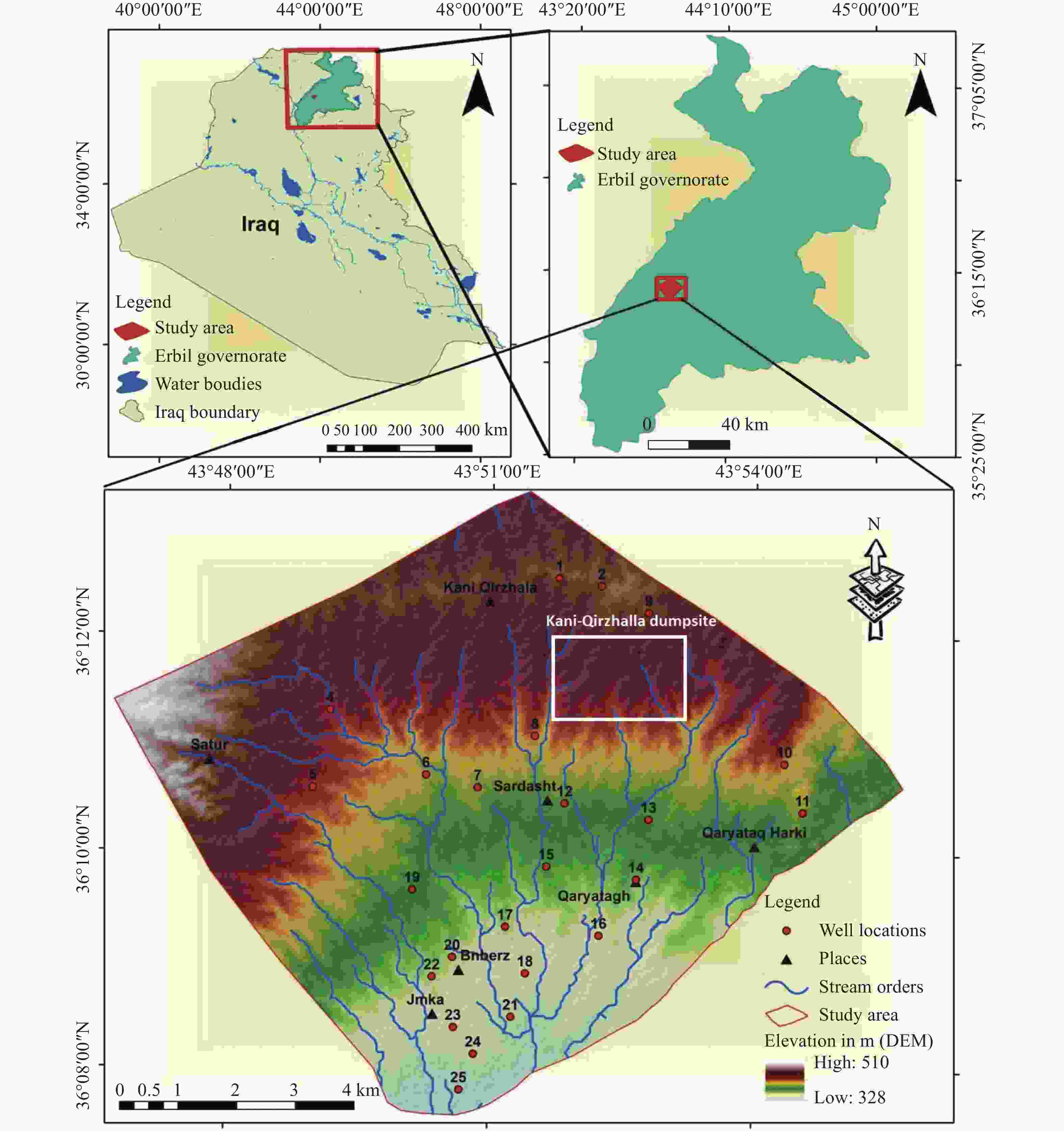
Groundwater vulnerability assessment using a GIS-based DRASTIC method in the Erbil Dumpsite area (Kani Qirzhala), Central Erbil Basin, North Iraq
-
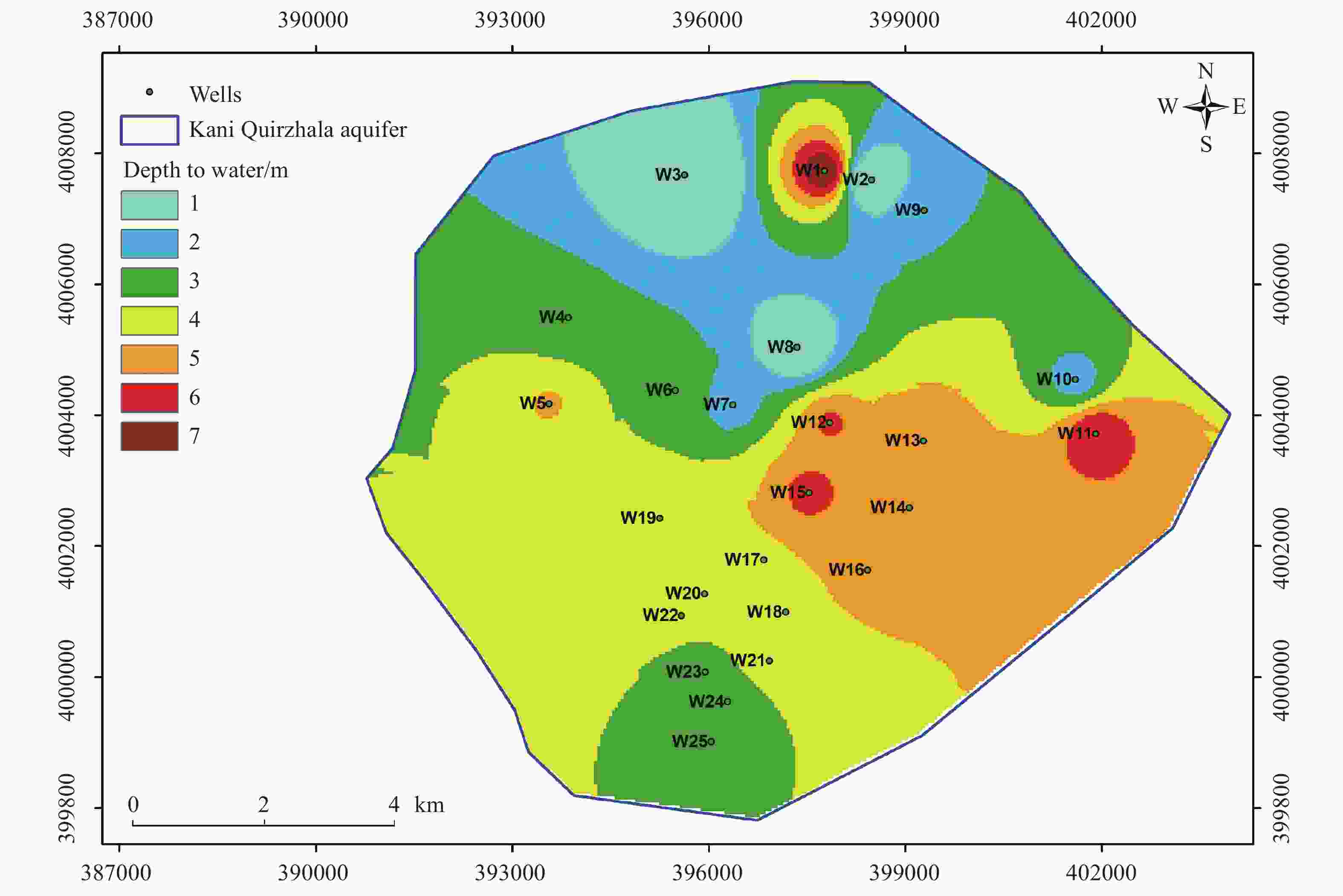
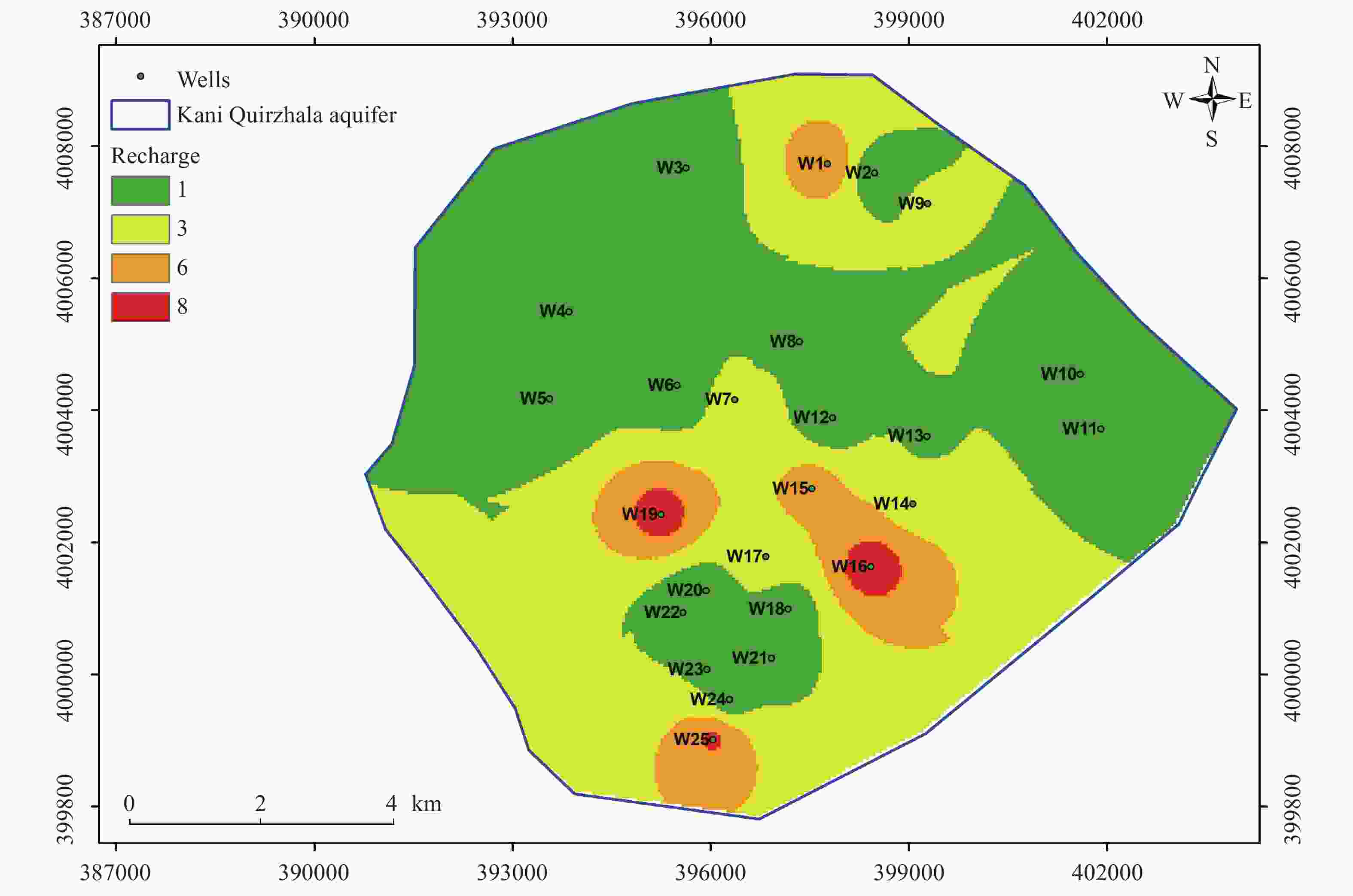
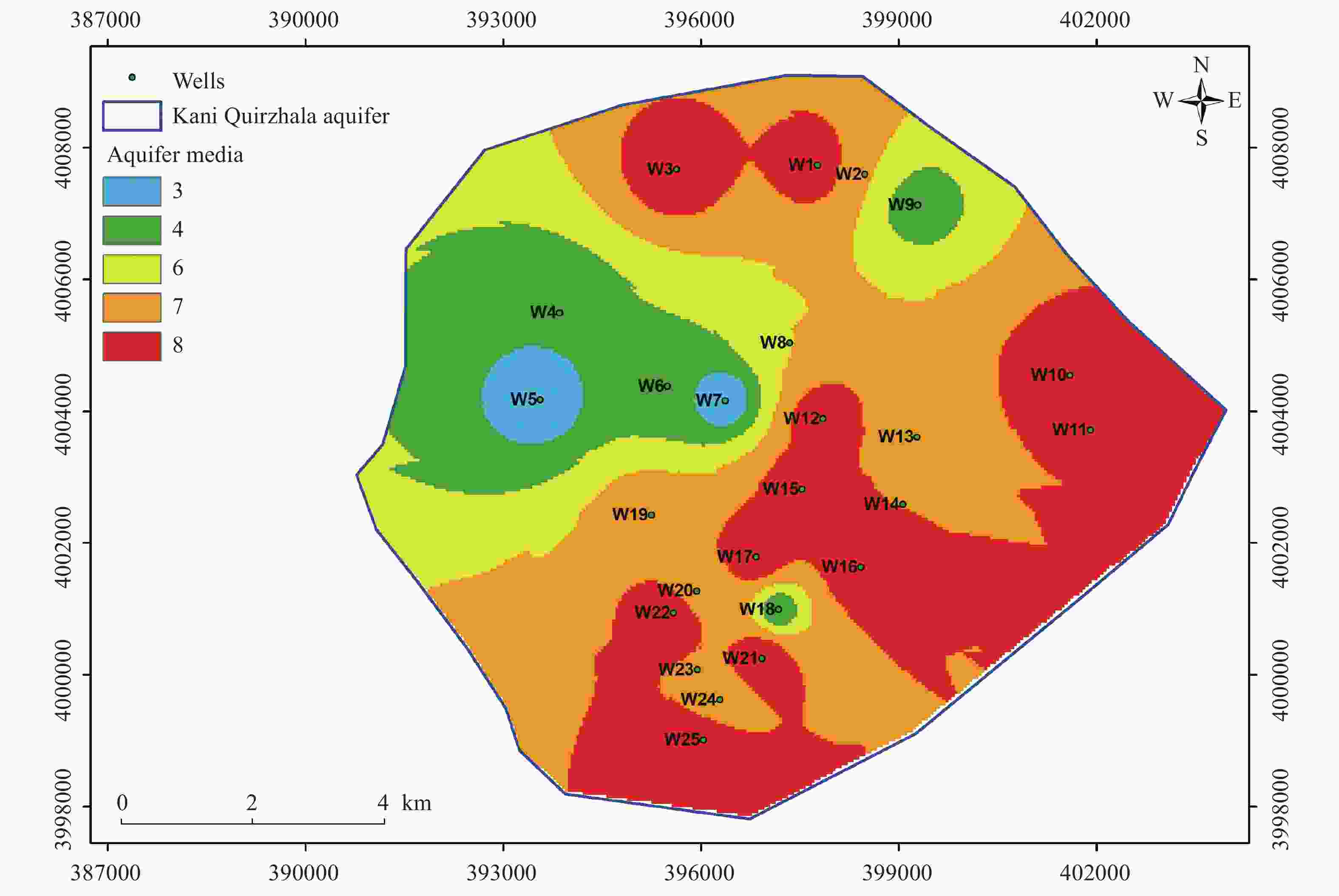
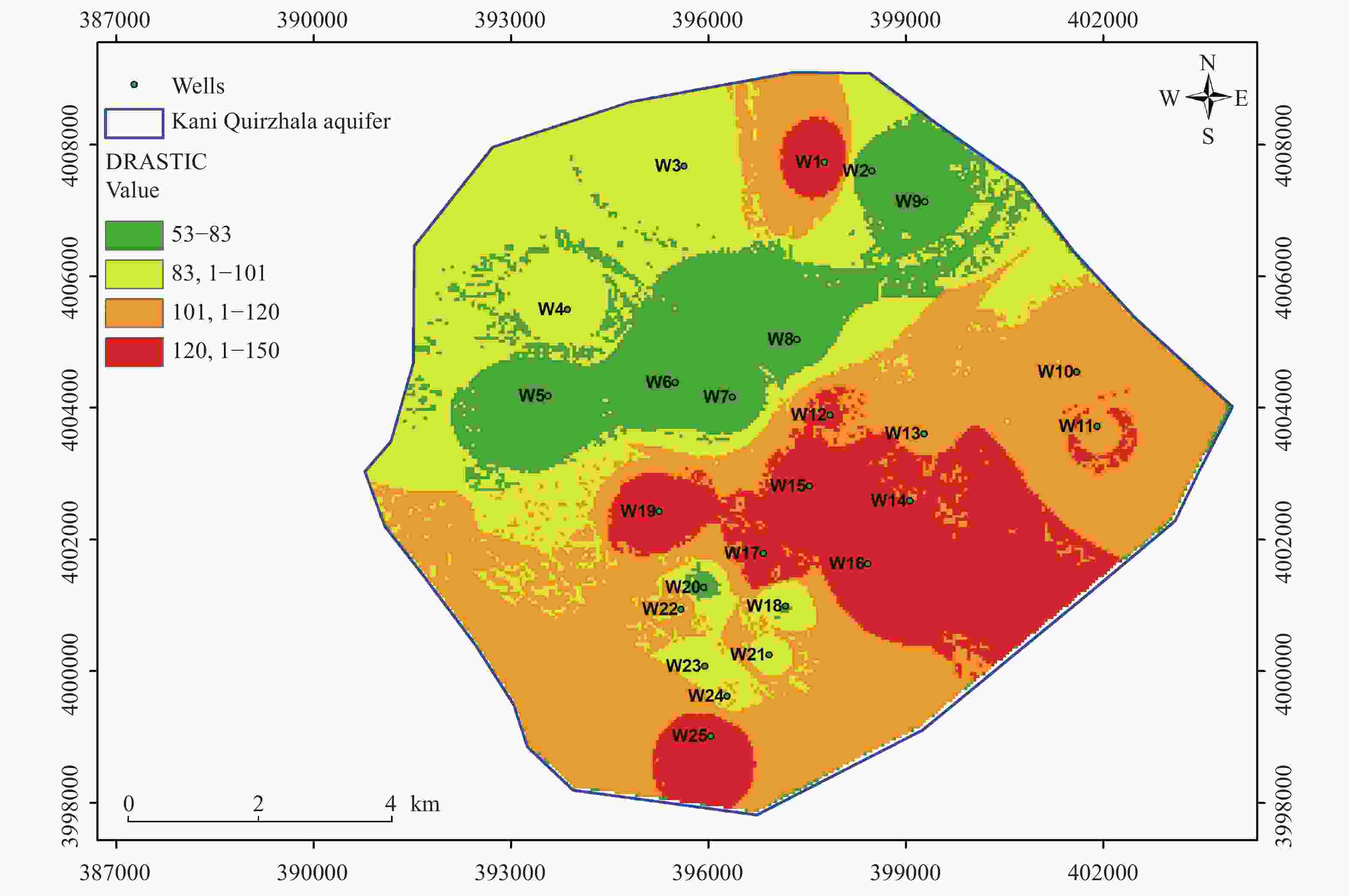
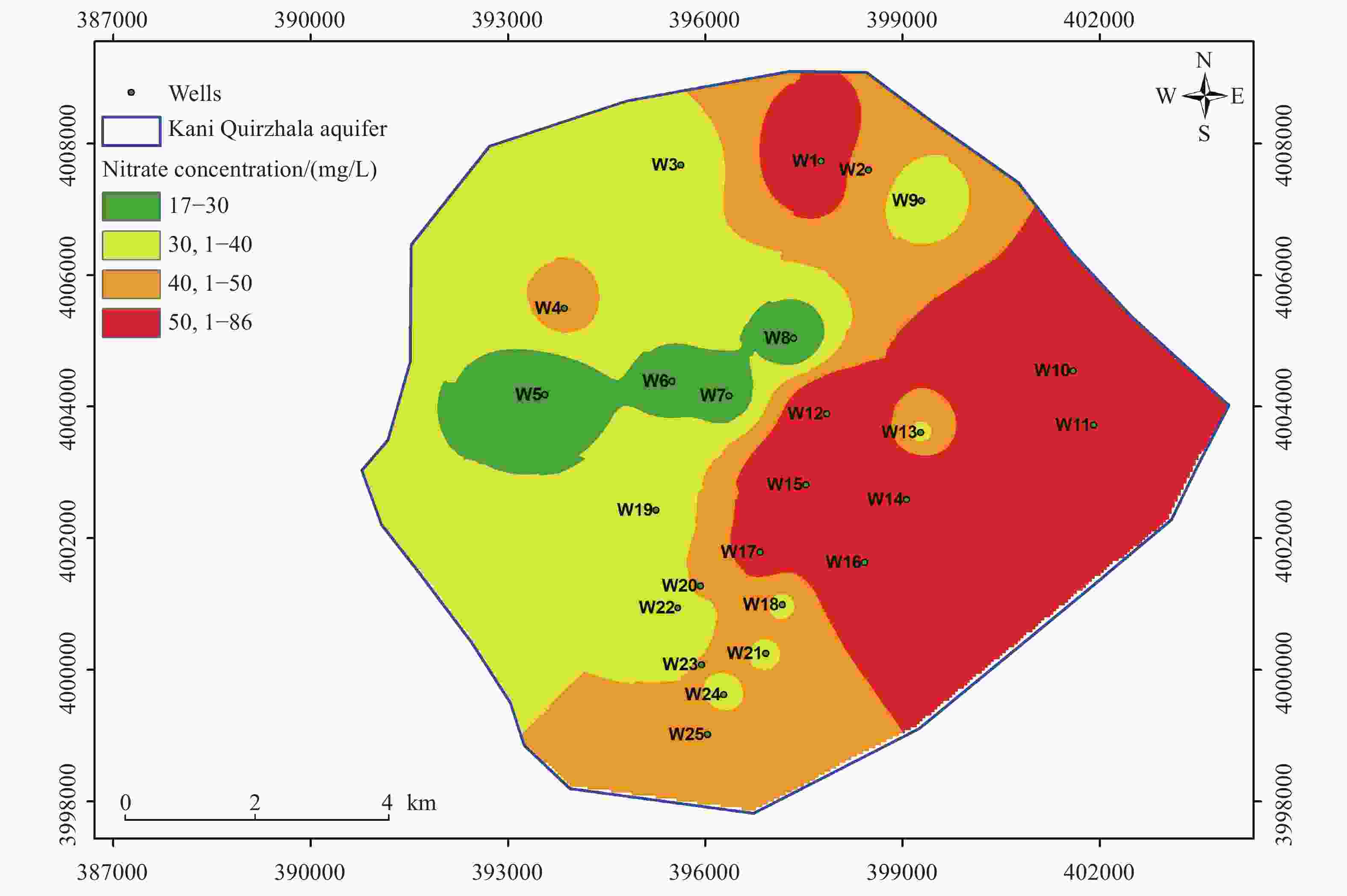
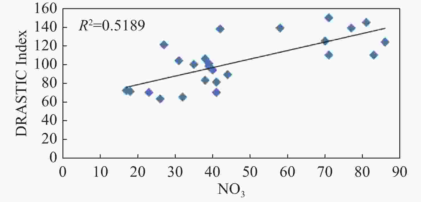
Abstract: Groundwater vulnerability assessment is a crucial step in the efficient management of groundwater resources, especially in areas with intensive anthropogenic activities and groundwater pollution. In the present study, the DRASTIC method was applied using Geographic Information System (GIS) to delineate groundwater vulnerability zones in the Erbil Dumpsite area, Central Erbil Basin, North Iraq. Results showed that the area was classified into four vulnerability classes: Very low (16.97%), low (27.67%), moderate (36.55%) and high (18.81%). The southern, south-eastern and northern parts of the study area exhibited the highest vulnerability potential, while the central-northern, northern and north-western regions displayed the lowest vulnerability potential. Moreover, results of the single-parameter sensitivity analysis indicated that amongst the seven DRASTIC parameters, the unsaturated zone and the aquifer media were the most influencing parameters. In conclustion, the correlation of 25 nitrate concentration values with the final vulnerability map, assessed using the Pearson correlation coefficient, yielded a satisfactory result of R = 0.72.
-
Key words:
- DRASTIC /
- Erbil /
- Iraq /
- Groundwater vulnerability assessment /
- Nitrate /
- Pollution /
- Sensitivity analysis
-
Table 1. Weight, ranges and ratings of DRASTIC parameters (Aller et al. 1987)
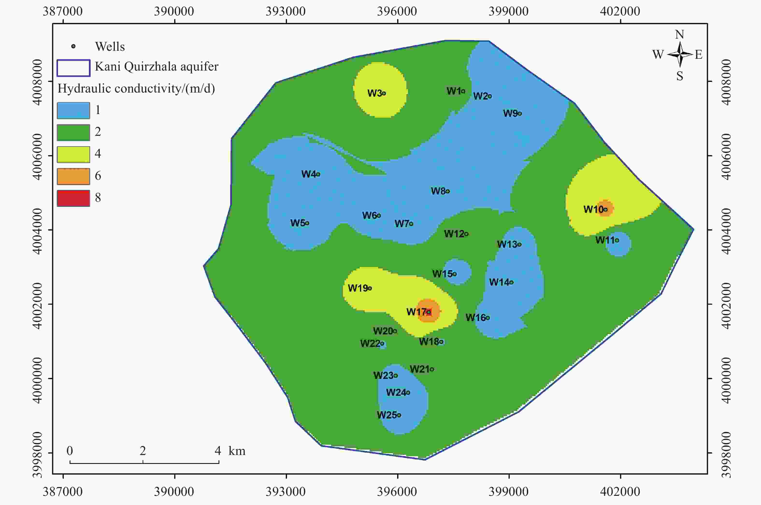
DRASTIC parameter Range/type Rating Standard weight D: Depth to water (m) 35–50 7 5 50–60 6 60–70 5 70–80 4 80–90 3 90–100 2 >100 1 R: Net recharge (mm/a) 0–50 1 4 50–100 3 100–175 6 175–246 8 A: Aquifer media Clay 3 3 Silty clay 4 Silty sand 6 Sand 7 Sandy gravel 8 S: Soil media Clay 2 2 Clay loam 3 Sandy loam 6 Silty sand 7 Fine sand 8 T: Topography (%) 0–2 10 1 2–6 9 6–12 5 12–18 3 >18 1 I: Impact of vadose zone Clay 2 5 Silty clay 3 Clay loam 4 Silty sand 6 Sand 7 Sandy gravel 8 C: Hydraulic conductivity (m/d) 0.04074–4.074 1 3 4.074–12.222 2 12.222–28.518 4 28.518–40.74 6 40.74–81.48 8 Table 2. Drastic index classes and spatial distribution
Vulnerability
classDRASTIC Index Area (km2) Area (%) Very low 53–83 17.11 16.97 Low 83–101 27.92 27.67 Moderate 101–120 36.87 36.55 High 120–150 18.97 18.81 Table 3. Statistics of single-parameter sensitivity analysis for DRASTIC
Parameter Theoretical weight Theoretical weight (%) Effective weight (%) Mean Min Max SD D 5 21.74 17.23 4.85 33.98 5.83 R 4 17.39 8.74 3.88 31.07 5.44 A 3 13.04 19.31 8.74 23.30 2.91 S 2 8.70 11.90 3.88 15.53 2.33 T 1 4.35 7.51 0.97 9.71 1.75 I 5 21.74 29.76 9.71 38.83 5.83 C 3 13.04 5.56 2.91 23.30 4.08 -
Abera KA, Gebreyohannes T, Abrha B, et al. 2022. Vulnerability mapping of groundwater resources of mekelle city and surroundings, tigray region, Ethiopia. Water, 14(16): 2577. DOI: 10.3390/w14162577. Ahmed I, Nazzal Y, Zaidi FK, et al. 2015. Hydrogeological vulnerability and pollution risk mapping of the Saq and overlying aquifers using the DRASTIC model and GIS techniques, NW Saudi Arabia. Environmental Earth Sciences, 74(2): 1303−1318. DOI: 10.1007/s12665-015-4120-5. Alamne SB, Assefa TT, Belay SA, et al. 2022. Mapping groundwater nitrate contaminant risk using the modified DRASTIC model: A case study in Ethiopia. Environmental Systems Research, 11(1): 8. DOI: 10.1186/s40068-022-00253-9. Al-Ansari NA. 2013. Management of water resources in Iraq: Perspectives and prognoses. Engineering, 5(8): 667−684. DOI: 10.4236/eng.2013.58080. Ali SS, Hamamin D. 2012. Groundwater vulnerability map of basara basin, sulaimani governorate, Iraqi Kurdistan region. Iraqi Journal of Science, 53(3): 579−594. Aller L, Bennett T, Lehr JH, et al. 1987. DRASTIC: A standardized system for evaluating groundwater pollution potential using hydrogeologic settings. US Environmental Protection Agency Report (EPA/600/2-87/035), Robert S. Kerr Environmental Research Laboratory: 455. Allouche N, Maanan M, Gontara M, et al. 2017. A global risk approach to assessing groundwater vulnerability. Environmental Modelling & Software, 88: 168−182. DOI: 10.1016/j.envsoft.2016.11.023. Babiker IS, Mohamed MAA, Hiyama T, et al. 2005. A GIS-based DRASTIC model for assessing aquifer vulnerability in Kakamigahara Heights, Gifu Prefecture, central Japan. Science of the Total Environment, 345(1−3): 127−140. Bernardo B, Candeias C, Rocha F. 2022. Integration of electrical resistivity and modified DRASTIC model to assess groundwater vulnerability in the surrounding area of hulene-B waste dump, Maputo, Mozambique. Water, 14(11): 1746. DOI: 10.3390/w14111746. Boufekane A, Yahiaoui S, Meddi H, et al. 2022. Modified DRASTIC index model for groundwater vulnerability mapping using geostatistic methods and GIS in the Mitidja Plain area (Algeria). Environmental Forensics, 23(5−6): 539−556. Brindha K, Elango L. 2015. Cross comparison of five popular groundwater pollution vulnerability index approaches. Journal of Hydrology, 524: 597−613. DOI: 10.1016/j.jhydrol.2015.03.003. Canora F, Muzzillo R, Sdao F. 2022. Groundwater vulnerability assessment in the metaponto coastal plain (basilicata, Italy). Water, 14(12): 1851. DOI: 10.3390/w14121851. Civita M. 1994. Le carte della vulnerabilita degli acquiferi al linquinamiento: Teoria e pratica [Contamination Vulnerability Mapping of the Aquifer: Theory and Practice]. Quaderni di Tecniche di Protezione Ambientale, Pitagora. Djémin JÉ, Kouamé JK, Deh KS, et al. 2016. Contribution of the sensitivity analysis in groundwater vulnerability assessing using the DRASTIC method: Application to groundwater in dabou region (southern of Côte d'Ivoire). Journal of Environmental Protection, 7(1): 129−143. DOI: 10.4236/jep.2016.71012. Ekanem AM, Ikpe EO, George NJ, et al. 2022. Integrating geoelectrical and geological techniques in GIS-based DRASTIC model of groundwater vulnerability potential in the raffia city of Ikot Ekpene and its environs, southern Nigeria. International Journal of Energy and Water Resources. El Yousfi Y, Himi M, Aqnouy M, et al. 2023. Pollution vulnerability of the ghiss nekkor alluvial aquifer in Al-hoceima (morocco), using GIS-based DRASTIC model. International Journal of Environmental Research and Public Health, 20(6): 4992. DOI: 10.3390/ijerph20064992. Ersoy AF, Gültekin F. 2013. DRASTIC-based methodology for assessing groundwater vulnerability in the Gümüshaciköy and Merzifon basin (Amasya, Turkey). Earth Science Resource Journal, 17(1): 33−40. Etuk M, Viaroli S, Ogbonnaya I, et al. 2022. Vulnerability mapping as a tool to foster groundwater protection in areas subject to rapid population expansion: The case study of Abuja Federal Capital Territory (Nigeria). Journal of Hydrology: Regional Studies, 42: 101158. DOI: 10.1016/j.ejrh.2022.101158. Fannakh A, Farsang A. 2022. DRASTIC, GOD, and SI approaches for assessing groundwater vulnerability to pollution: A review. Environmental Sciences Europe, 34(1): 77. DOI: 10.1186/s12302-022-00646-8. Foster SSD. 1987. Fundamental concepts in aquifer vulnerability, pollution risk and protection strategy. Vulnerability of Soil and Groundwater to Pollutants. Hydrology Research Hague, Proceding and Information, 38: 69–86. Gardi SQS. 2017. Environmental impact assessment of Erbil Dumpsite area-west of Erbil City-Iraqi Kurdistan Region. Journal of Tethys, 5(3): 194−217. Garewal SK, Vasudeo AD, Landge VS, et al. 2017. A GIS-based Modified DRASTIC (ANP) method for assessment of groundwater vulnerability: A case study of Nagpur city, India. Water Quality Research Journal, 52(2): 121−135. DOI: 10.2166/wqrj.2017.046. Gogu RC, Dassargues A. 2000. Current trends and future challenges in groundwater vulnerability assessment using overlay and index methods. Environmental Geology, 39(6): 549−559. DOI: 10.1007/s002540050466. Gonçalves V, Albuquerque A, Carvalho P, et al. 2023. Groundwater vulnerability assessment to cemeteries pollution through GIS-based DRASTIC index. Water, 15(4): 812. DOI: 10.3390/w15040812. Goyal D, Haritash AK, Singh SK. 2021. A comprehensive review of groundwater vulnerability assessment using index-based, modelling, and coupling methods. Journal of Environmental Management, 296: 113161. DOI: 10.1016/j.jenvman.2021.113161. Green TR, Taniguchi M, Kooi H, et al. 2011. Beneath the surface of global change: Impacts of climate change on groundwater. Journal of Hydrology, 405(3−4): 532−560. Hamza SM, Ahsan A, Imteaz MA, et al. 2015. Accomplishment and subjectivity of GIS-based DRASTIC groundwater vulnerability assessment method: A review. Environmental Earth Sciences, 73(7): 3063−3076. DOI: 10.1007/s12665-014-3601-2. Hasan M, Islam MA, Aziz Hasan M, et al. 2019. Groundwater vulnerability assessment in Savar upazila of Dhaka district, Bangladesh—a GIS-based DRASTIC modeling. Groundwater for Sustainable Development, 9: 100220. DOI: 10.1016/j.gsd.2019.100220. Ifediegwu SI, Chibuike IE. 2021. GIS-based evaluation of shallow aquifer vulnerability to pollution using DRASTIC model: A case study on Abakaliki, southeastern, Nigeria. Arabian Journal of Geosciences, 14(23): 2534. DOI: 10.1007/s12517-021-08811-8. Jain H. 2023. Groundwater vulnerability and risk mitigation: A comprehensive review of the techniques and applications. Groundwater for Sustainable Development, 22: 100968. DOI: 10.1016/j.gsd.2023.100968. Jawad SB, Hussien KA. 1988. Groundwater monitoring network rationalization using statistical analyses of piezometric fluctuation. Hydrological Sciences Journal, 33(2): 181−191. DOI: 10.1080/02626668809491237. Jhariya DC, Kumar T, Pandey HK, et al. 2019. Assessment of groundwater vulnerability to pollution by modified DRASTIC model and analytic hierarchy process. Environmental Earth Sciences, 78(20): 610. DOI: 10.1007/s12665-019-8608-2. Jmal I, Ayed B, Bahloul M, et al. 2022. Contribution of GIS tools and statistical approaches to optimize the DRASTIC model for groundwater vulnerability assessment in arid and semi-arid regions: The case of Sidi Bouzid shallow aquifer. Arabian Journal of Geosciences, 15(10): 974. DOI: 10.1007/s12517-022-10149-8. Khosravi K, Sartaj M, Karimi M, et al. 2021. A GIS-based groundwater pollution potential using DRASTIC, modified DRASTIC, and bivariate statistical models. Environmental Science and Pollution Research, 28(36): 50525−50541. DOI: 10.1007/s11356-021-13706-y. Kirlas MC, Karpouzos DK, Georgiou PE, et al. 2023. A GIS-based comparative groundwater vulnerability assessment using modified-DRASTIC, modified-SINTACS and NV index in a porous aquifer, Greece. Environments, 10(6): 95. DOI: 10.3390/environments10060095. Kirlas MC. 2021. Assessment of porous aquifer hydrogeological parameters using automated groundwater level measurements in Greece. Journal of Groundwater Science and Engineering, 9(4): 269−278. DOI: 10.19637/j.cnki.2305-7068.2021.04.001. Kirlas MC, Karpouzos DÎ, Georgiou PE, et al. 2022a. A comparative study of groundwater vulnerability methods in a porous aquifer in Greece. Applied Water Science, 12(6): 123. DOI: 10.1007/s13201-022-01651-1. Kirlas MC, Karpouzos DΚ, Georgiou PE, et al. 2022b. Groundwater vulnerability assessment in Nea Moudania (Chalkidiki) aquifer, using the DRASTIC and AHP-DRASTIC methods. 15th Conference of the Hellenic Hydrotechnical Association (H. H. A.) Koon AB, Anornu GK, Dekongmen BW, et al. 2023. Evaluation of groundwater vulnerability using GIS-based DRASTIC model in Greater Monrovia, Montserrado County, Liberia. Urban Climate, 48: 101427. DOI: 10.1016/j.uclim.2023.101427. Kumar P, Bansod BKS, Debnath SK, et al. 2015. Index-based groundwater vulnerability mapping models using hydrogeological settings: A critical evaluation. Environmental Impact Assessment Review, 51: 38−49. DOI: 10.1016/j.eiar.2015.02.001. Kumar P, Sharma R, Bhaumik S. 2022. MCDA techniques used in optimization of weights and ratings of DRASTIC model for groundwater vulnerability assessment. Data Science and Management, 5(1): 28−41. DOI: 10.1016/j.dsm.2022.03.004. Kumar P, Thakur PK, Bansod BKS, et al. 2018. Groundwater: A regional resource and a regional governance. Environment, Development and Sustainability, 20(3): 1133−1151. Li X, Ye S, Wang LH, et al. 2017. Tracing groundwater recharge sources beneath a reservoir on a mountain-front plain using hydrochemistry and stable isotopes. Water Supply, 17(5): 1447−1457. DOI: 10.2166/WS.2017.036. Machiwal D, Jha MK, Singh VP, et al. 2018. Assessment and mapping of groundwater vulnerability to pollution: Current status and challenges. Earth-Science Reviews, 185: 901−927. DOI: 10.1016/j.earscirev.2018.08.009. Mawlood DK. 2019. Sustainability of aquifer and ground water condition in Erbil Basin/Iraq. Zanco Journal of Pure and Applied Sciences, 31(6). Mensah DO, Appiah-Adjei EK, Asante D. 2023. Groundwater pollution vulnerability assessment in the Assin municipalities of Ghana using GIS-based DRASTIC and SINTACS methods. Modeling Earth Systems and Environment, 9(2): 2955−2967. DOI: 10.1007/s40808-022-01680-4. Metwally MI, Armanuos AM, Zeidan BA. 2023. Comparative study for assessment of groundwater vulnerability to pollution using DRASTIC methods applied to central Nile Delta, Egypt. International Journal of Energy and Water Resources, 7(2): 175−190. DOI: 10.1007/s42108-022-00198-w. Mkumbo NJ, Mussa KR, Mariki EE, et al. 2022. The use of the DRASTIC-LU/LC model for assessing groundwater vulnerability to nitrate contamination in Morogoro Municipality, Tanzania. Earth, 3(4): 1161−1184. DOI: 10.3390/earth3040067. Muhammad AM, Tang ZH, Dawood AS, et al. 2015. Evaluation of local groundwater vulnerability based on DRASTIC index method in Lahore, Pakistan. Geofísica Internacional, 54(1): 67−81. DOI: 10.1016/j.gi.2015.04.003. Napolitano P, Fabbri A. 1996. Single-parameter sensitivity analysis for aquifer vulnerability assessment using DRASTIC and SINTACS. Application of Geographic Information Systems in Hydrology and Water Resources Management (Proceedings of the Vienna Conference, April 1996). IAHS Publication, 235: 559–566. Neshat A, Pradhan B. 2017. Evaluation of groundwater vulnerability to pollution using DRASTIC framework and GIS. Arabian Journal of Geosciences, 10(22): 501. DOI: 10.1007/s12517-017-3292-6. Noori R, Ghahremanzadeh H, Kløve B, et al. 2019. Modified-DRASTIC, modified-SINTACS and SI methods for groundwater vulnerability assessment in the southern Tehran aquifer. Journal of Environmental Science and Health. Part A, Toxic/Hazardous Substances & Environmental Engineering, 54(1): 89−100. Oke SA. 2020. Regional aquifer vulnerability and pollution sensitivity analysis of drastic application to Dahomey Basin of Nigeria. International Journal of Environmental Research and Public Health, 17(7): E2609. DOI: 10.3390/ijerph17072609. Omeje ET, Obiora DN, Okeke FN, et al. 2023. Investigation of aquifer vulnerability and sensitivity analysis of modified drastic and sintacs models: A case study of Ovogovo Area, Eastern Nigeria. Acta Geophysica, 71(5): 2439−2464. DOI: 10.1007/s11600-022-00992-4. Ouedraogo I, Defourny P, Vanclooster M. 2016. Mapping the groundwater vulnerability for pollution at the pan African scale. Science of the Total Environment, 544: 939−953. DOI: 10.1016/j.scitotenv.2015.11.135. Patel P, Mehta D, Sharma N. 2022. A review on the application of the DRASTIC method in the assessment of groundwater vulnerability. Water Supply, 22(5): 5190−5205. DOI: 10.2166/ws.2022.126. Patle D, Nema S, Awasthi MK, et al. 2022. Groundwater vulnerability assessment using DRASTIC model in Niwari District of Bundelkhand Region, Madhya Pradesh, India. Arabian Journal of Geosciences, 15(20): 1590. DOI: 10.1007/s12517-022-10870-4. Phok R, Kosgallana DWN, Sumana BW, et al. 2021. Using intrinsic vulnerability and anthropogenic impacts to evaluate and compare groundwater risk potential at northwestern and western coastal aquifers of Sri Lanka through coupling DRASTIC and GIS approach. Applied Water Science, 11(7): 117. DOI: 10.1007/s13201-021-01452-y. Pouye A, Faye SC, Di Ãdhiou M, et al. 2022. An evaluation of groundwater vulnerability assessment methods in a rapidly urbanizing city: Evidence from Dakar, Senegal. Environmental Earth Sciences, 81(16): 410. DOI: 10.1007/s12665-022-10531-5. Rauf LF, Ali SS, Al-Ansari N. 2022. Groundwater vulnerability of halabja-khurmal sub-basin using modified DRASTIC method. Water, Air & Soil Pollution, 233(11): 440. Rezig A, Marinangeli L, Saggai S. 2022. Comparative study for assessing vulnerability to pollution in El Asnam plain, North of Algeria. Water Supply, 22(6): 5894−5914. DOI: 10.2166/ws.2022.216. Ribeiro L. 2000. SI: A new index of aquifer susceptibility to agricultural pollution. Internal report, ERSHA/CVRM, Instituto Superior Técnico, Lisbon, Portugal: 12. Saidi S, Bouri S, Ben Dhia H, et al. 2011. Assessment of groundwater risk using intrinsic vulnerability and hazard mapping: Application to Souassi aquifer, Tunisian Sahel. Agricultural Water Management, 98(10): 1671−1682. DOI: 10.1016/j.agwat.2011.06.005. Salih AO, Ali Al-Manmi D. 2021. DRASTIC model adjusted with lineament density to map groundwater vulnerability: A case study in Rania Basin, Kurdistan, Iraq. Environmental Science and Pollution Research, 28(42): 59731−59744. DOI: 10.1007/s11356-021-14912-4. Sarkar M, Pal SC. 2021. Application of DRASTIC and modified DRASTIC models for modeling groundwater vulnerability of malda district in West Bengal. Journal of the Indian Society of Remote Sensing, 49(5): 1201−1219. DOI: 10.1007/s12524-020-01176-7. Sener EH, Davraz A. 2013. Assessment of groundwater vulnerability based on a modified DRASTIC model, GIS and an analytic hierarchy process (AHP) method: The case of Egirdir Lake Basin (Isparta, Turkey). Hydrogeology Journal, 21(3): 701−714. DOI: 10.1007/s10040-012-0947-y. Sener E, Sener Ş. 2015. Evaluation of groundwater vulnerability to pollution using fuzzy analytic hierarchy process method. Environmental Earth Sciences, 73(12): 8405−8424. DOI: 10.1007/s12665-014-4001-3. Shakeri R, Alijani F, Nassery HR. 2023. Comparison of the DRASTIC Land modified VABHAT models in vulnerability assessment of Karaj aquifer, central Iran, using MCDM, SWARA, and BWM methods. Environmental Earth Sciences, 82(4): 97. DOI: 10.1007/s12665-023-10773-x. Singha SS, Pasupuleti S, Singha S, et al. 2019. A GIS-based modified DRASTIC approach for geospatial modeling of groundwater vulnerability and pollution risk mapping in Korba district, Central India. Environmental Earth Sciences, 78(21): 628. DOI: 10.1007/s12665-019-8640-2. Sissakian VK, Al-Ansari N, Adamo N, et al. 2022. Flood hazards in erbil City Kurdistan region Iraq, 2021: A case study. Engineering, 14(12): 591−601. DOI: 10.4236/eng.2022.1412044. Taghavi N, Niven RK, Kramer M, et al. 2023. Comparison of DRASTIC and DRASTICL groundwater vulnerability assessments of the Burdekin Basin, Queensland, Australia. Science of the Total Environment, 858: 159945. DOI: 10.1016/j.scitotenv.2022.159945. Taghavi N, Niven RK, Paull DJ, et al. 2022. Groundwater vulnerability assessment: A review including new statistical and hybrid methods. Science of the Total Environment, 822: 153486. DOI: 10.1016/j.scitotenv.2022.153486. Torkashvand M, Neshat A, Javadi S, et al. 2023. Groundwater vulnerability to nitrate contamination from fertilizers using modified DRASTIC frameworks. Water, 15(17): 3134. DOI: 10.3390/w15173134. United Nations. 2020. Climate change exacerbates existing conflict risks, likely to create new ones, Assistant Secretary-General Warns Security Council. https://www.un.org/press/en/2020/sc14260.doc.html Van Stempvoort D, Ewert L, Wassenaar L. 1993. Aquifer vulnerability index: A GIS - compatible method for groundwater vulnerability mapping. Canadian Water Resources Journal, 18(1): 25−37. DOI: 10.4296/cwrj1801025. Victorine Neh A, Ako Ako A, Richard Ayuk A, et al. 2015. DRASTIC-GIS model for assessing vulnerability to pollution of the phreatic aquiferous formations in Douala-Cameroon. Journal of African Earth Sciences, 102: 180−190. DOI: 10.1016/j.jafrearsci.2014.11.001. Wei A, Bi P, Guo J, et al. 2021. Modified DRASTIC model for groundwater vulnerability to nitrate contamination in the Dagujia river basin, China. Water Supply, 21(4): 1793−1805. DOI: 10.2166/ws.2021.018. Xiong HX, Wang YZ, Guo X, et al. 2022. Current status and future challenges of groundwater vulnerability assessment: A bibliometric analysis. Journal of Hydrology, 615: 128694. DOI: 10.1016/j.jhydrol.2022.128694. -

 E-mail alert
 Rss
Rss


 下载:
下载:
