 E-mail alert
 Rss
Rss

Analysis of driving factors for land subsidence in typical cities of the North China Plain based on geodetector technology
-
Abstract: The North China Plain is vital hub for agricultural production and urban development. However, decades of excessive groundwater extraction have resulted on significant land subsidence, posing severe threats to the region's socio-economic stability and sustainable development. The relationship between land deformation and groundwater storage Anomalies in this region remains insufficiently understood, and the driving factors behind land subsidence require further exploration. This study employs downscaled GRACE and SBAS InSAR technologies to monitor and analyze land subsidence and groundwater storage Anomalies in four representative cities of the North China Plain: Beijing, Tianjin, Cangzhou, and Hengshui. Using geodetector methods, the study investigates the driving factors of land subsidence, incorporating both natural environmental and human activity factors. The results indicate that: (1) Groundwater storage in the North China Plain generally exhibited an overall declining trend from 2002 to 2022, with the rate of decrease weakening from southwest to northeast, showing a clear spatial clustering pattern. (2) While, land subsidence rates in the main urban areas of each city were relatively low, severe subsidence persisted in the surrounding suburban and rural areas. (3) The temporal trends of land subsidence were consistent with changes in groundwater storage across all cities. (4) Groundwater storage Anomalies emerged as the most significant factor influencing the spatial distribution of land subsidence, with a q-value of 0.387, followed by factors such as DEM, evapotranspiration, and rainfall. Seasonal characteristics were evident in land deformation corresponding to groundwater storage Anomalies: During the spring and summer irrigation periods, land subsidence occurred due to groundwater depletion, while in autumn and winter, the surface uplifted with increased groundwater storage. In Cangzhou and Hengshui, excessive deep groundwater extraction caused a lagged response in land subsidence relative to groundwater storage Anomalies. Furthermore, interaction among various factors significantly amplified their influence on land subsidence. The interaction between groundwater storage Anomalies and rainfall had the strongest combined effect, underscoring its critical role in shaping land subsidence in the study area. The findings offer valuable insights for the scientific prevention and management of land subsidence in the North China Plain.
-
Key words:
- Land subsidence /
- InSAR /
- groundwater storage Anomalies /
- Geodetector /
- GRACE
-
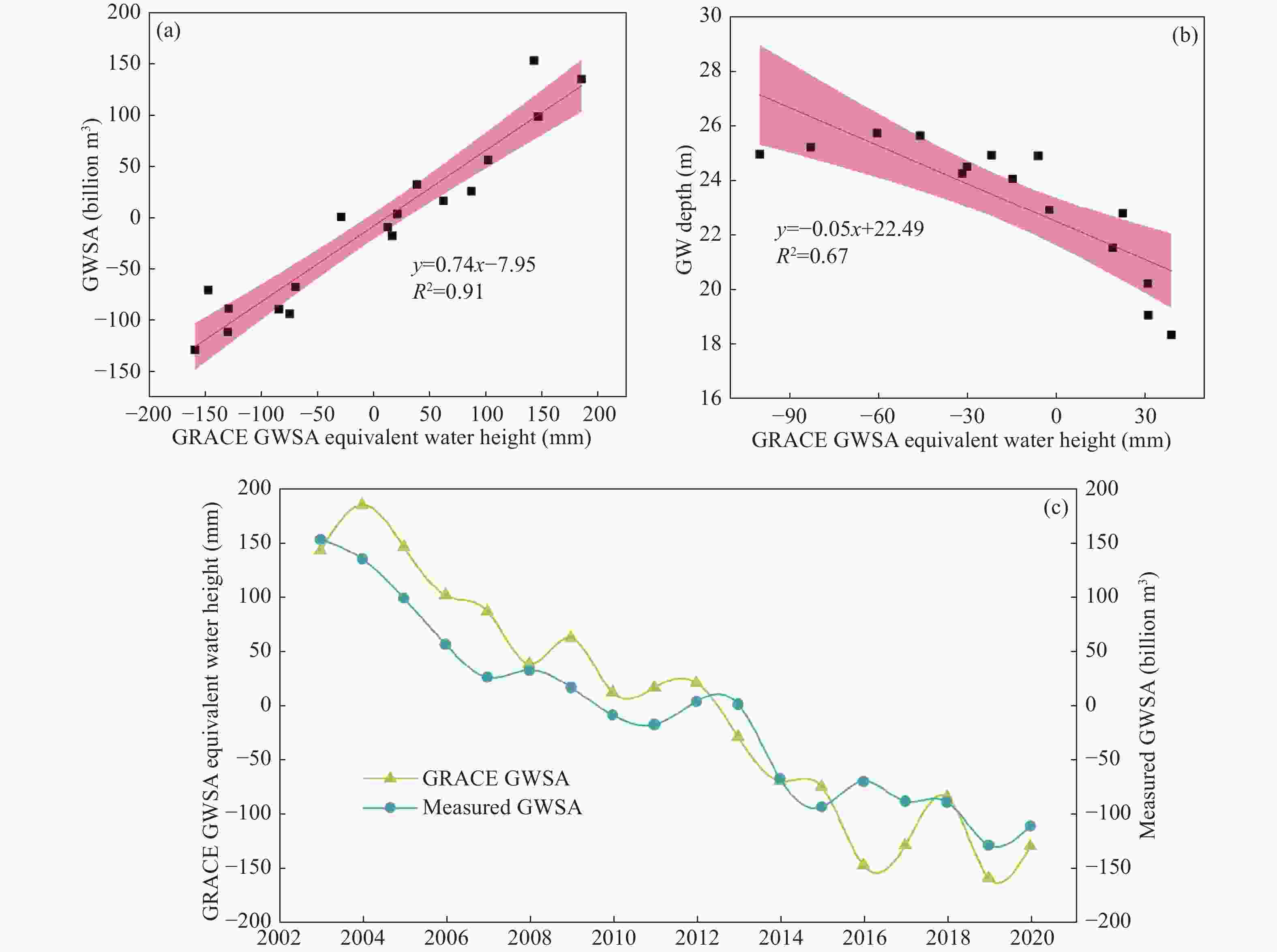
Figure 2. Validation of GRACE downscaled groundwater storage
Note: (a) Relationship of shallow groundwater storage Anomalies in the Haihe River Basin based on the Haihe River Basin Water Resources Bulletin; (b) GWSA relationship in the Beijing plain area based on the Beijing Water Resources Bulletin; (c) Comparison of characteristics between GRACE downscaled GWSA and Haihe River Basin Water Resources Bulletin data.
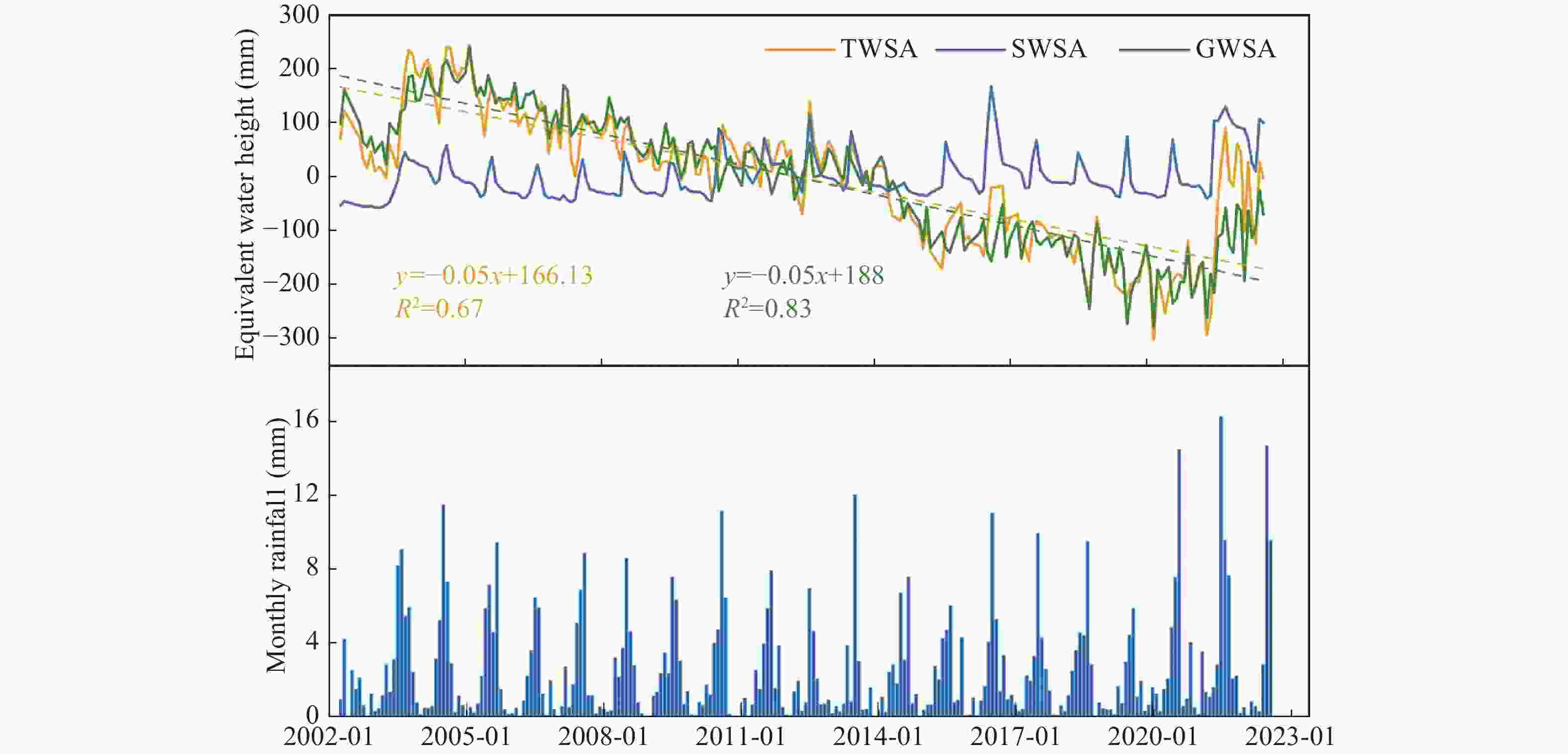
Figure 4. Time series of TWSA, SWSA, and GWSA changes in the North China Plain and monthly precipitation variations
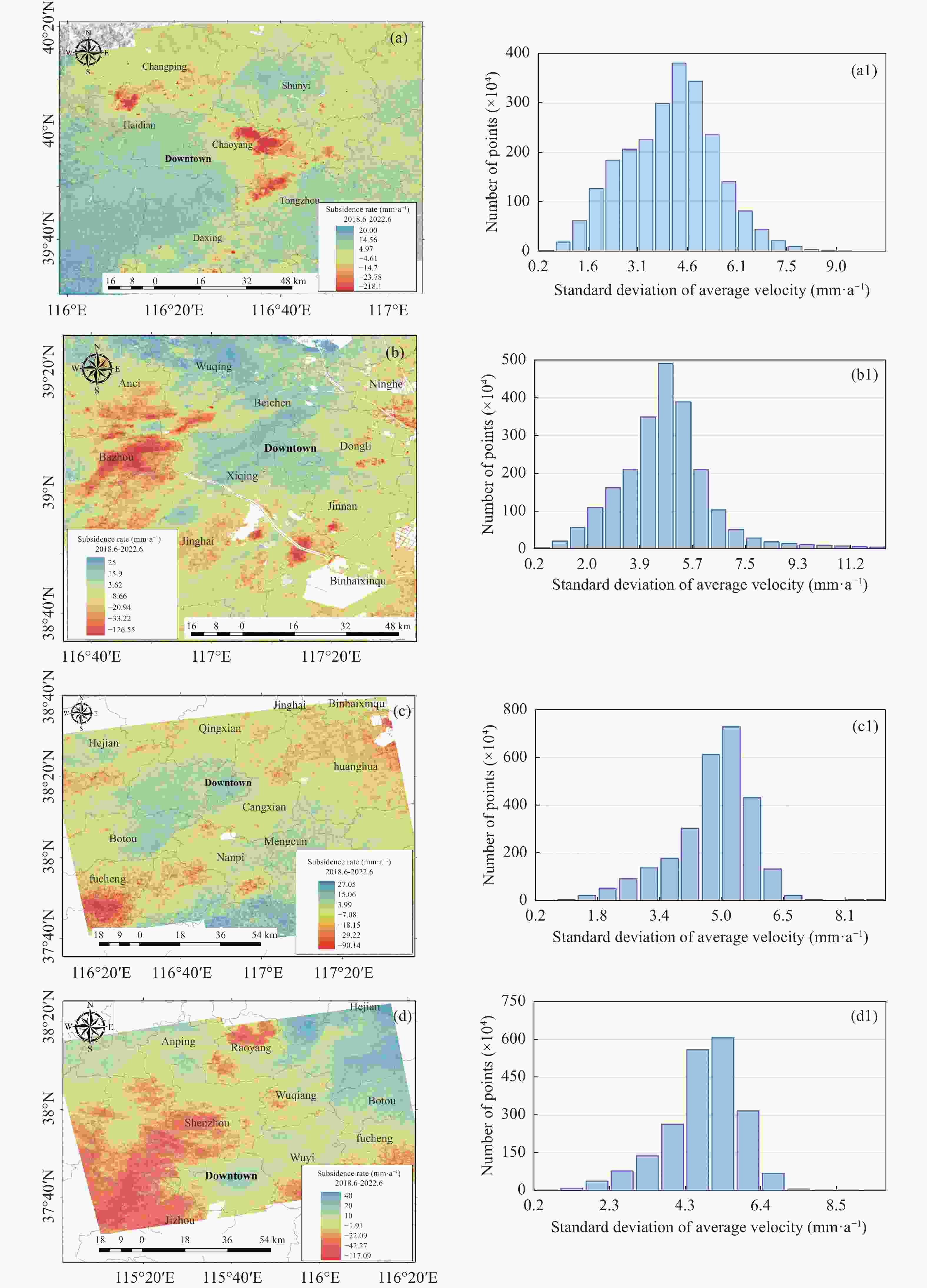
Figure 6. Spatial distribution of annual average land subsidence rates and standard deviations in different cities
Note: (a, b, c, d) represent the spatial distribution of subsidence rates in Beijing, Tianjin, Cangzhou, and Hengshui, respectively; (a1, b1, c1, d1) represent the standard deviation distribution of subsidence rates in Beijing, Tianjin, Cangzhou, and Hengshui, respectively.
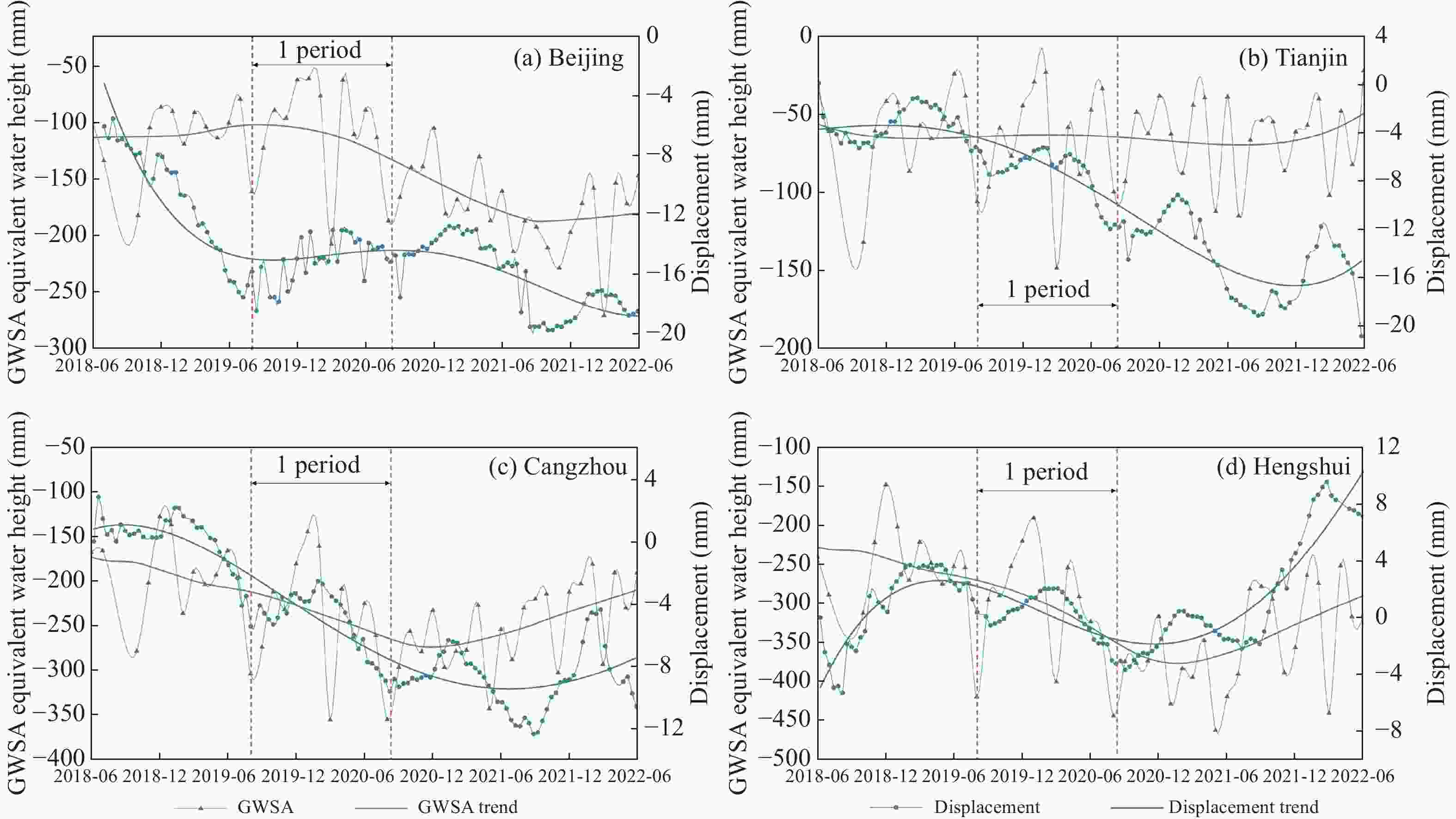
Figure 7. Relationship between GWSA and land deformation in different cities
Note: a, b, c, d represent Beijing, Tianjin, Hengshui, and Cangzhou, respectively.
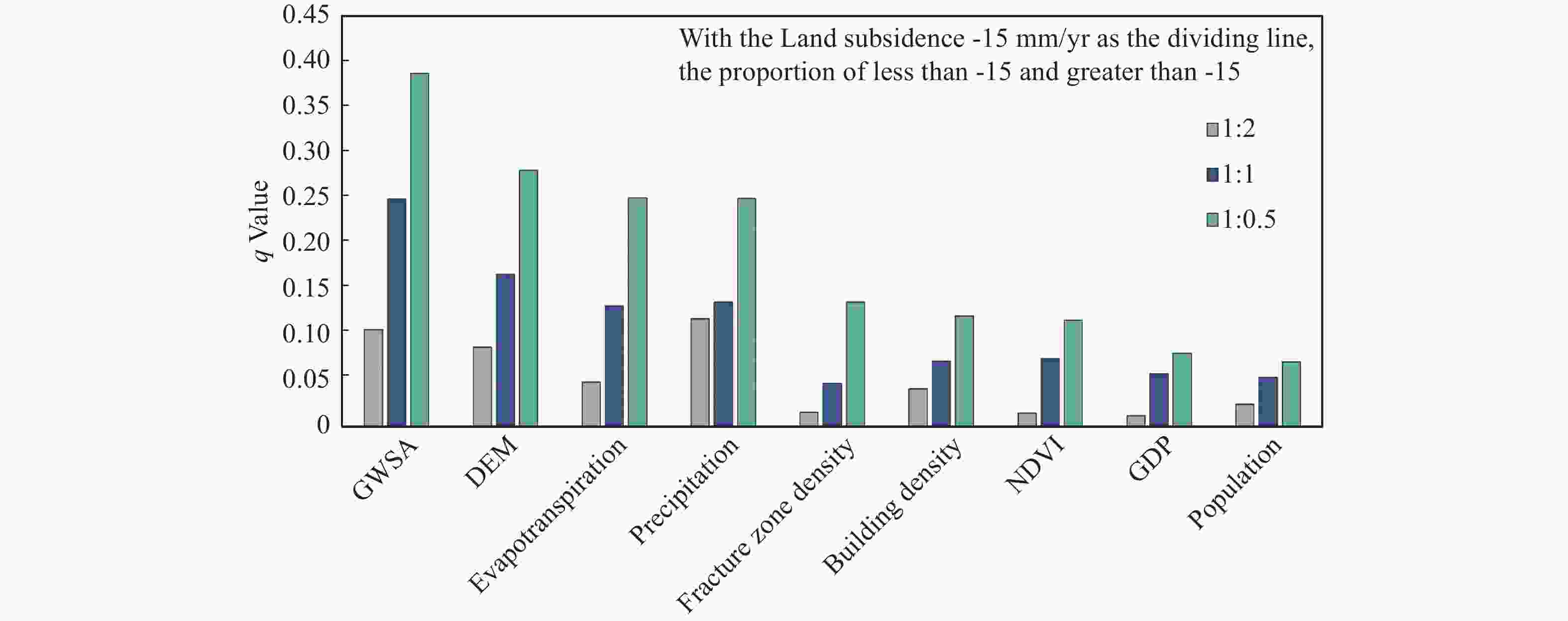
Figure 9. Changes in the q-value of each influencing factor at different sample ratios
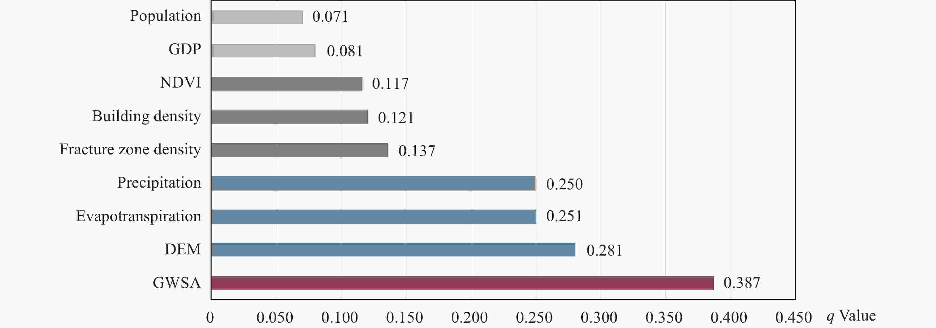
Figure 10. q-values of each influencing factor for ground subsidence in the study area
Table 1. Description of different driving factors
Data name Data description Data source North China Plain GRACE GWSA spatial distribution Using GRACE downscaled results, the GWSA change rate for the North China Plain from 2002 to 2022 was obtained. Spatial resolution: 1 km. —— Fault scale index Based on fault line data, the length of fault lines within a 1 km grid is calculated. Spatial resolution: 1 km. —— Annual rainfall spatial distribution The 2019 monthly precipitation data is accumulated annually. Spatial resolution: 1 km. National Earth System Science Data Center Evapotranspiration spatial distribution Based on the 2019 GLASS and MODIS products, inversion results are used. Spatial resolution: 1 km. Spatio-Temporal Environment Big Data Platform NDVI spatial distribution Inversion based on 2019 SPOT data. Spatial resolution: 1 km. National Earth System Science Data Center DEM spatial distribution SRTM3 DEM data, spatial resolution: 90 m. Geospatial Data Cloud Building density spatial distribution Based on the 2019 land use data for the North China Plain, building land area within a 1 km grid is calculated. Spatial resolution: 1 km. Zenodo Population spatial distribution 2019 population spatial distribution data for China, in 1 km grid. Spatial resolution: 1 km. Resource and Environment Science GDP spatial distribution 2019 GDP spatial distribution data for China, in 1 km grid. Spatial resolution: 1 km. Resource and Environment Science  下载: 导出CSV
-
Agarwal V, Akyilmaz O, Shum CK, et al. 2023. Machine learning based downscaling of GRACE-estimated groundwater in Central Valley, California. Science of the total Environment, 865: 161138. DOI: 10.1016/j.scitotenv.2022.161138. An Y, Yang F, Xu J, et al. 2024. Surface deformation analysis and prediction of groundwater changes from joint sar-grace satellite data. IEEE Access, 12: 33671−33686, DOI: 10.1109/ACCESS.2024.3368423. Bagheri-Gavkosh M, Hosseini SM, Ataie-Ashtiani B, et al. 2021. Land subsidence: A global challenge. Science of the Total Environment, 778(6): 146193. DOI: 10.1016/j.scitotenv.2021.146193. Berardino P, Fornaro G, Lanari R, et al. 2002. A new algorithm for surface deformation monitoring based on small baseline differential SAR interferograms. IEEE Transactions on Geoscience and Remote Sensing, 40(11): 2375−2383. DOI: 10.1109/TGRS.2002.803792. Cao Q, Zhang Y, Yang L, et al. 2024. Unveiling the driving factors of urban land subsidence in Beijing, China. Science of the Total Environment, 916: 170134. DOI: 10.1016/j.scitotenv.2024.170134. Huang ZY, Pan Y, Gong HL, et al. 2015. Subregional‐scale groundwater depletion detected by GRACE for both shallow and deep aquifers in North China Plain. Geophysical Research Letters, 42(6): 1791−1799. DOI: 10.1002/2014GL062498. Gong HL, Pan Y, Zheng LQ, et al. 2018. Long-term groundwater storage changes and land subsidence development in the North China Plain (1971–2015). Hydrogeology Journal, 26(5): 1417−1427. DOI: 10.1007/s10040-018-1768-4. Guo HP, Bai JB, Zhang YQ, et al. 2017. The evolution characteristics and mechanism of the land subsidence in typical areas of the North China Plain. Geology in China, 44(6): 1115−1127. (in Chinese) DOI: 10.12029/gc20170606. Guo HP, Li WP, Wang LY, et al. 2021. Present situation and research prospects of the land subsidence driven by groundwater levels in the North China Plain. Hydrogeology & Engineering Geology, 48(3): 162−171. (in Chinese) DOI: 10.16030/j.cnki.issn.1000-3665.202012037. Khorrami B, Gunduz O. 2021. Evaluation of the temporal variations of groundwater storage and its interactions with climatic variables using GRACE data and hydrological models: A study from Turkey. Hydrological Processes, 35(3): e14076. DOI: 10.1002/hyp.14076. Lei KC, Luo Y, Chen BB, et al. 2016. Distribution characteristics and influence factors ofland subsidence in Beijing area. Geology in China, 43(6): 2216−2228. (in Chinese) DOI: 10.12029/gc20160628. Li X, Ye SY, Song F, et al. 2018. Quantitative identification of major factors affecting groundwater change in Beijing-Tianjin-Hebei Plain. Journal of China Hydrology, 38(01): 21−27. (in Chinese) DOI: 10.3969/j.issn.1000-0852.2018.01.004. Lin JH, Chen WH, Qi XH, et al. 2021. Risk assessment and its influencing factors analysis of geological hazards in typical mountain environment. Journal of Cleaner Production, 309: 127077. DOI: 10.1016/j.jclepro.2021.127077. Lin M, Biswas A, Bennett EM. 2019. Spatio-temporal dynamics of groundwater storage changes in the Yellow River Basin. Journal of Environmental Management, 235: 84−95. DOI: 10.1016/j.jenvman.2019.01.016. Liu HL, Zhang GQ, Zhang DS, et al. 2022. Improving the spatial resolution of GRACE satellites based on high-resolution hydrological simulations. Bulletin of Surveying and Mapping, 0(8): 41−47. (in Chinese) DOI: 10.13474/j.cnki.11-2246.2022.0230. Liu ZQ, Zhang SW, Fan WJ, et al. 2024. Associations between surface deformation and groundwater storage in different landscape areas of the Loess Plateau, China. Land, 13(2): 184. DOI: 10.3390/land13020184. Pan Y, Zhang C, Gong HL, et al. 2017. Detection of human-induced evapotranspiration using GRACE satellite observations in the Haihe River basin of China. Geophysical Research Letters, 44(1): 190−199. DOI: 10.1002/2016GL071287. Peng SZ, Ding YX, Liu WZ, et al. 2019. 1 km monthly temperature and precipitation dataset for China from 1901 to 2017. Earth System Science Data, 11(4): 1931−1946. DOI: 10.5194/essd-11-1931-2019,2019. Peng SZ, Gang CC, Cao Y, et al. 2018. Assessment of climate change trends over the Loess Plateau in China from 1901 to 2100. International Journal of Climatology, 38(5): 2250−2264. DOI: 10.1002/joc.5331. Singh L, Saravanan S. 2020. Satellite-derived GRACE groundwater storage variation in complex aquifer system in India. Sustainable Water Resources Management, 6(3): 43. DOI: 10.1007/s40899-020-00399-3. Sorkhabi OM, Asgari J. 2023. Multi-sensor observations for monitoring groundwater depletion and land subsidence. Journal of Hydrology: Regional Studies, 50: 101529. DOI: 10.1016/j.ejrh.2023.101529. Su YZ, Guo B, Zhou ZT, et al. 2020. Spatio-temporal variations in groundwater revealed by GRACE and its driving factors in the Huang-Huai-Hai Plain, China. Sensors, 20(3): 922. DOI: 10.3390/s20030922. Wang JF, Xu CD. 2017. Geodetector: Principle and prospective. Acta Geographica Sinica, 72(1): 116−134. (in Chinese) DOI: 10.11821/dlxb201701010. Xu CJ, He P, Wen YM, et al. 2015. Recent advances InSAR interferometry and its applications. Journal of Geomatics, 40(2): 1−9. (in Chinese) DOI: 10.14188/j.2095-6045.2015.02.001. Xue DP, Gui DW, Ci MT, et al. 2024. Spatial and temporal downscaling schemes to reconstruct high-resolution GRACE data: A case study in the Tarim River Basin, Northwest China. Science of the Total Environment, 907: 167908. DOI: 10.1016/j.scitotenv.2023.167908. Yu W, Gong HL , Chen BB, et al. 2021. Combined GRACE and MT-InSAR to assess the relationship between groundwater storage cchange and land subsidence in the BeijZing-Tianjin-Hebei Region. Remote Sensing, 13(18): 3773. DOI: 10.3390/rs13183773. Zhang XY, Ruan YC, Xuan WH, et al. 2023. Risk assessment and spatial regulation on urban ground collapse based on geo-detector: A case study of Hangzhou urban area. NaturalHazards, 118: 525−543. DOI: 10.1007/s11069-023-06016-8. Zhang Y, Liu YF, Liu Y, et al. 2022. Spatial-temproal variation characteristics and geographic detection mechanism of land subsidence in wuhan city from 2007 to 2019. Geomatics and Information Science of Wuhan University, 47(9): 1486−1497. (in Chinese) DOI: 10.13203/j.whugis20210143. Zhong YL, Feng W, Zhong M, et al. 2020. Dataset of reconstructed terrestrial water storage in China based on precipitation (2002–2019). A Big Earth Data Platform for ThreePoles. CSTR: 18406.11.Hydro.tpdc.270990. DOI: 10.11888/Hydro.tpdc.270990. -


 点击查看大图
计量
- 文章访问数: 1516
- HTML全文浏览量: 567
- PDF下载量: 44
- 被引次数: 0


