• ISSN 2305-7068
  • Indexed by ESCI CABI CAS
  • DOAJ Scopus GeoRef AJ CNKI
Advanced Search

2023 Vol. 11, No. 4

Display Method:
Research Paper
Using geospatial technologies to delineate Ground Water Potential Zones (GWPZ) in Mberengwa and Zvishavane District, Zimbabwe
Nyasha Ashleigh Siziba, Pepukai Chifamba
2023, 11(4): 317-332. doi: 10.26599/JGSE.2023.9280026
Abstract(773) FullText HTML (385) PDF(204)
Abstract:
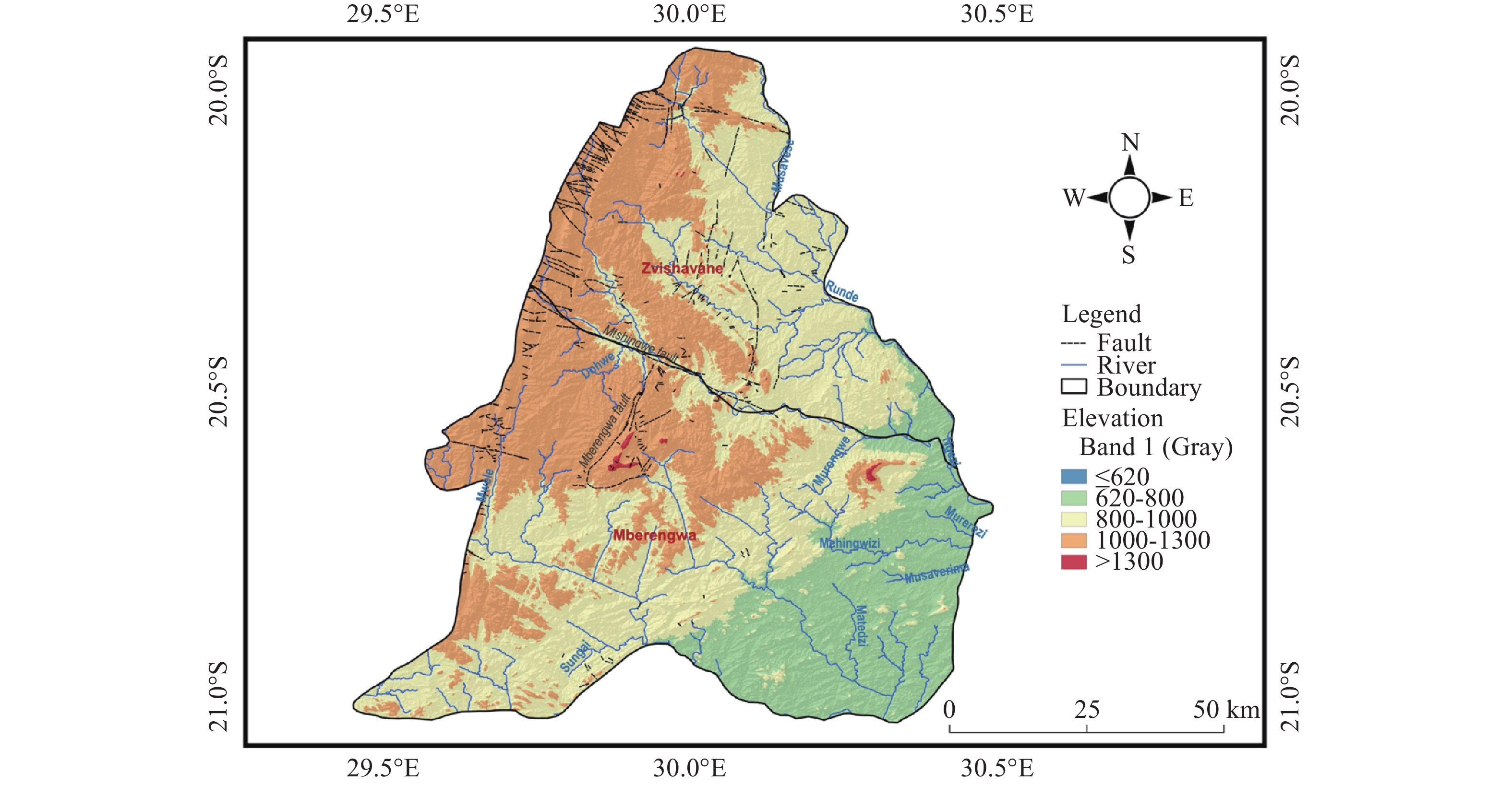
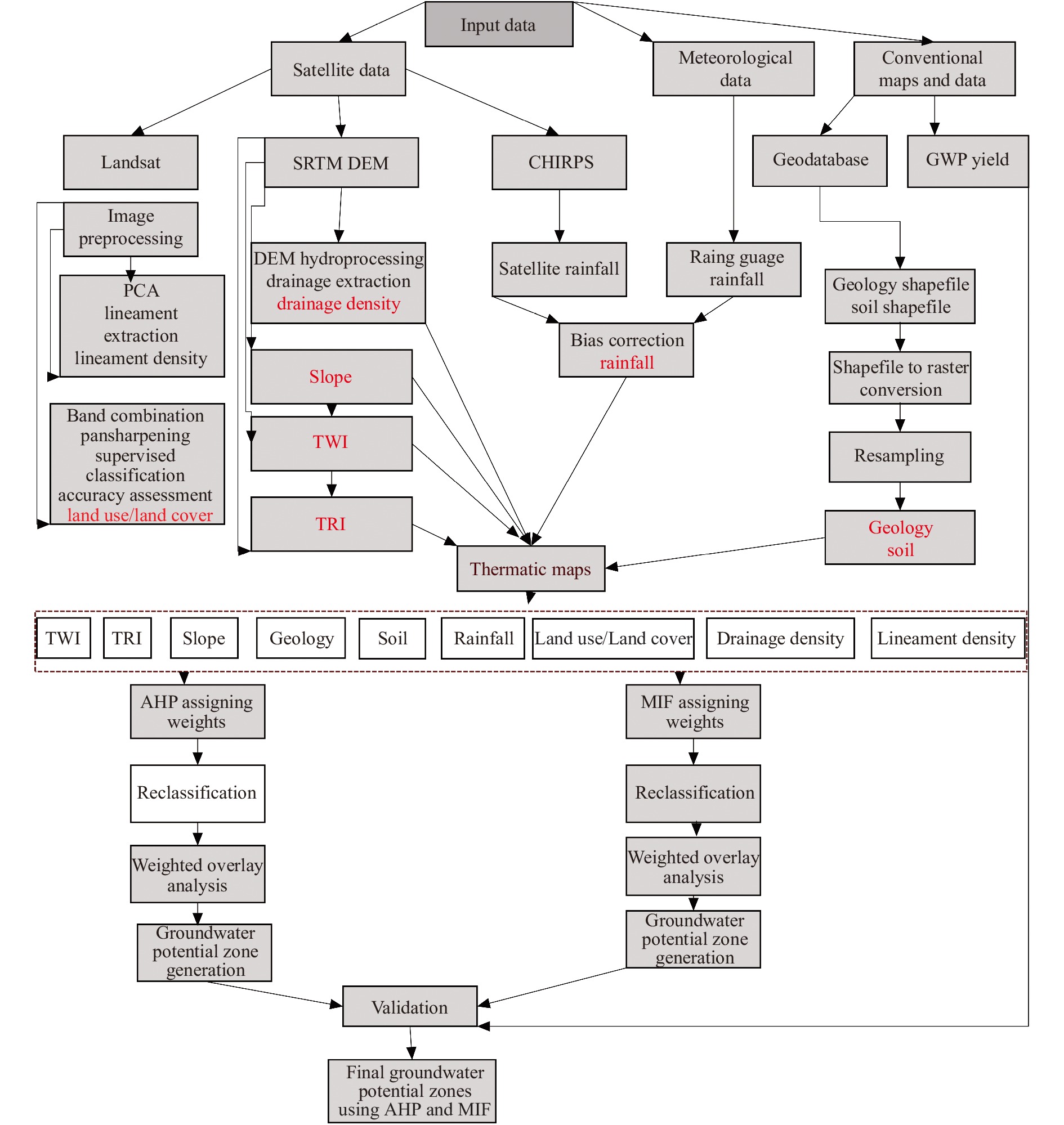
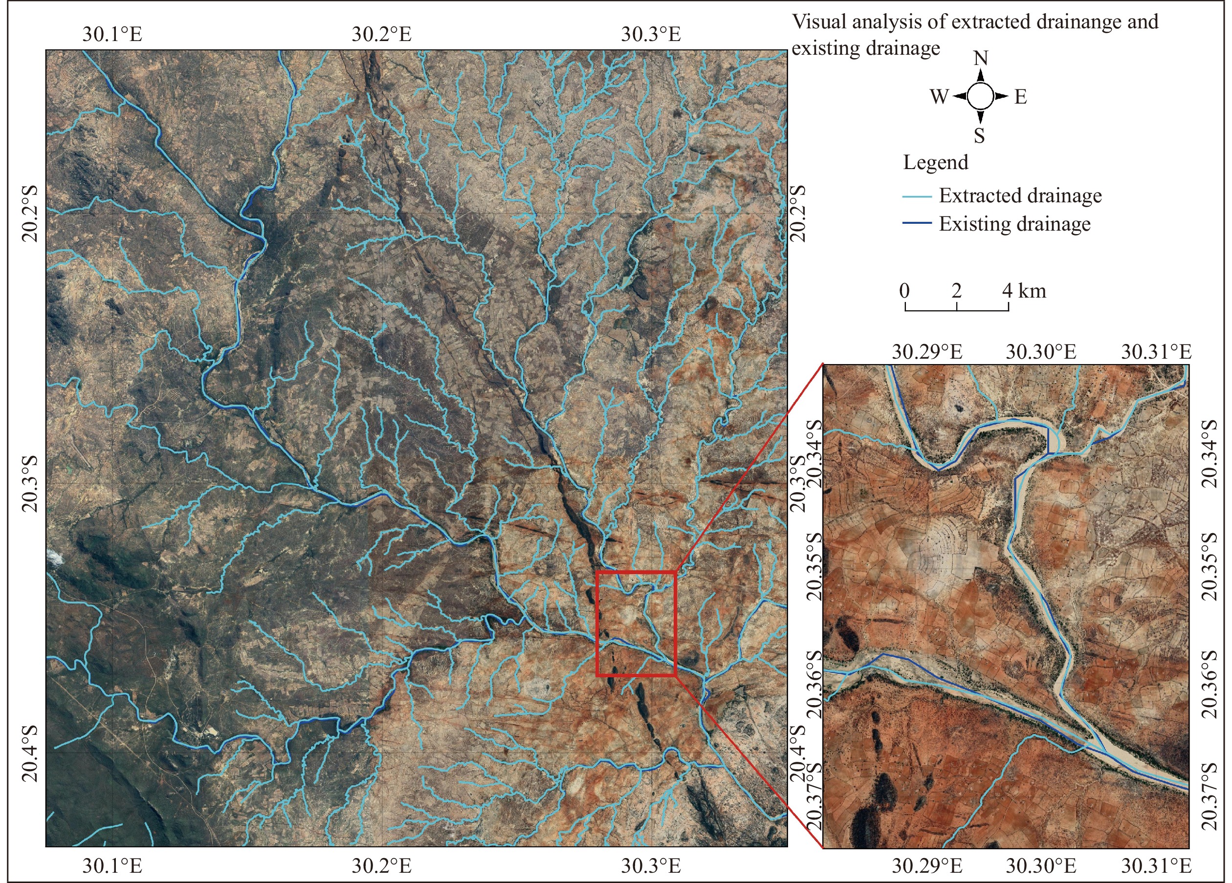
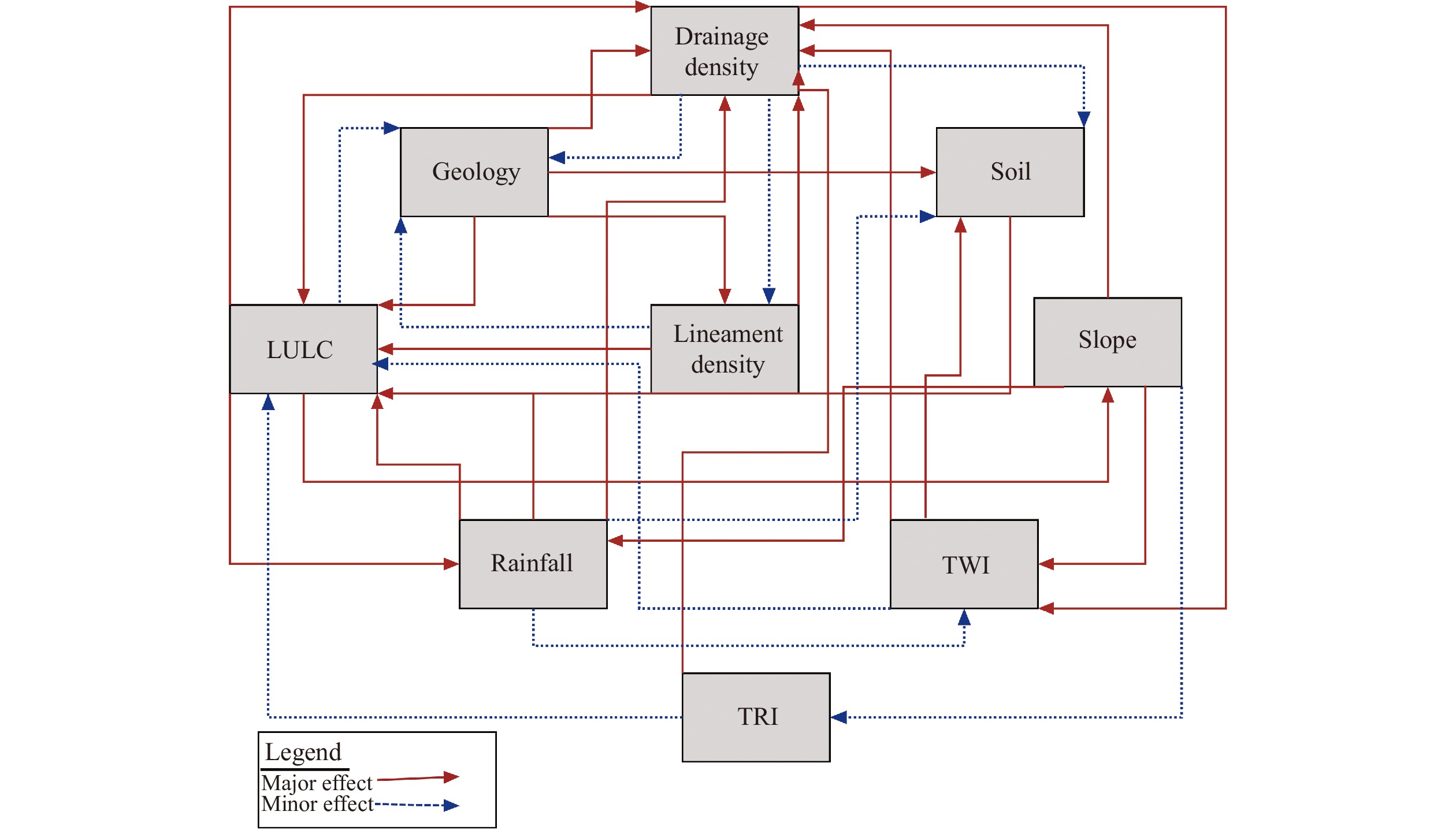
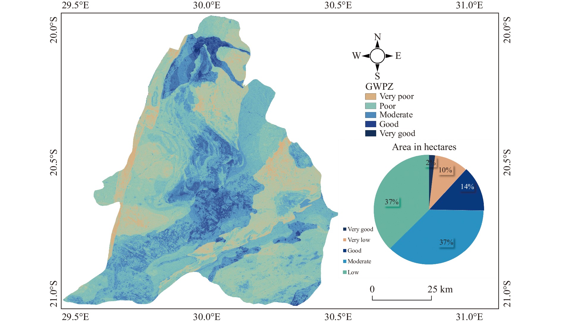
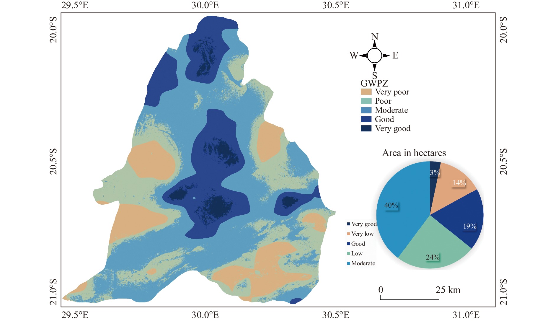
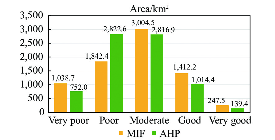
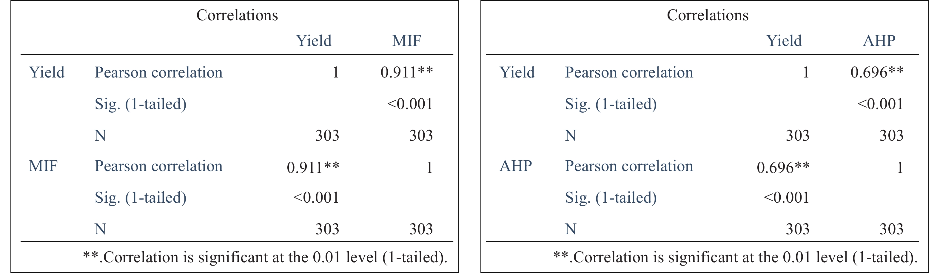
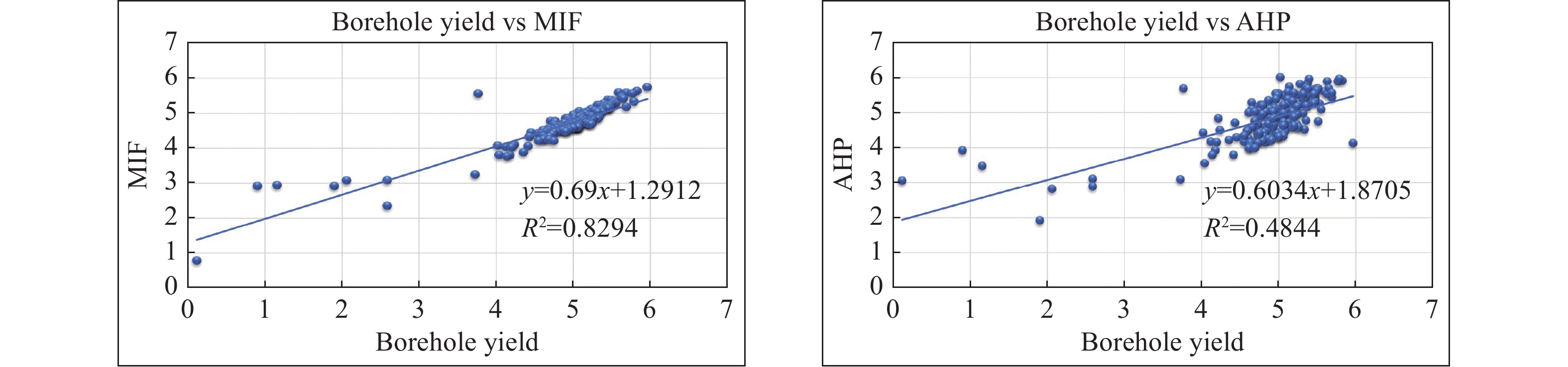
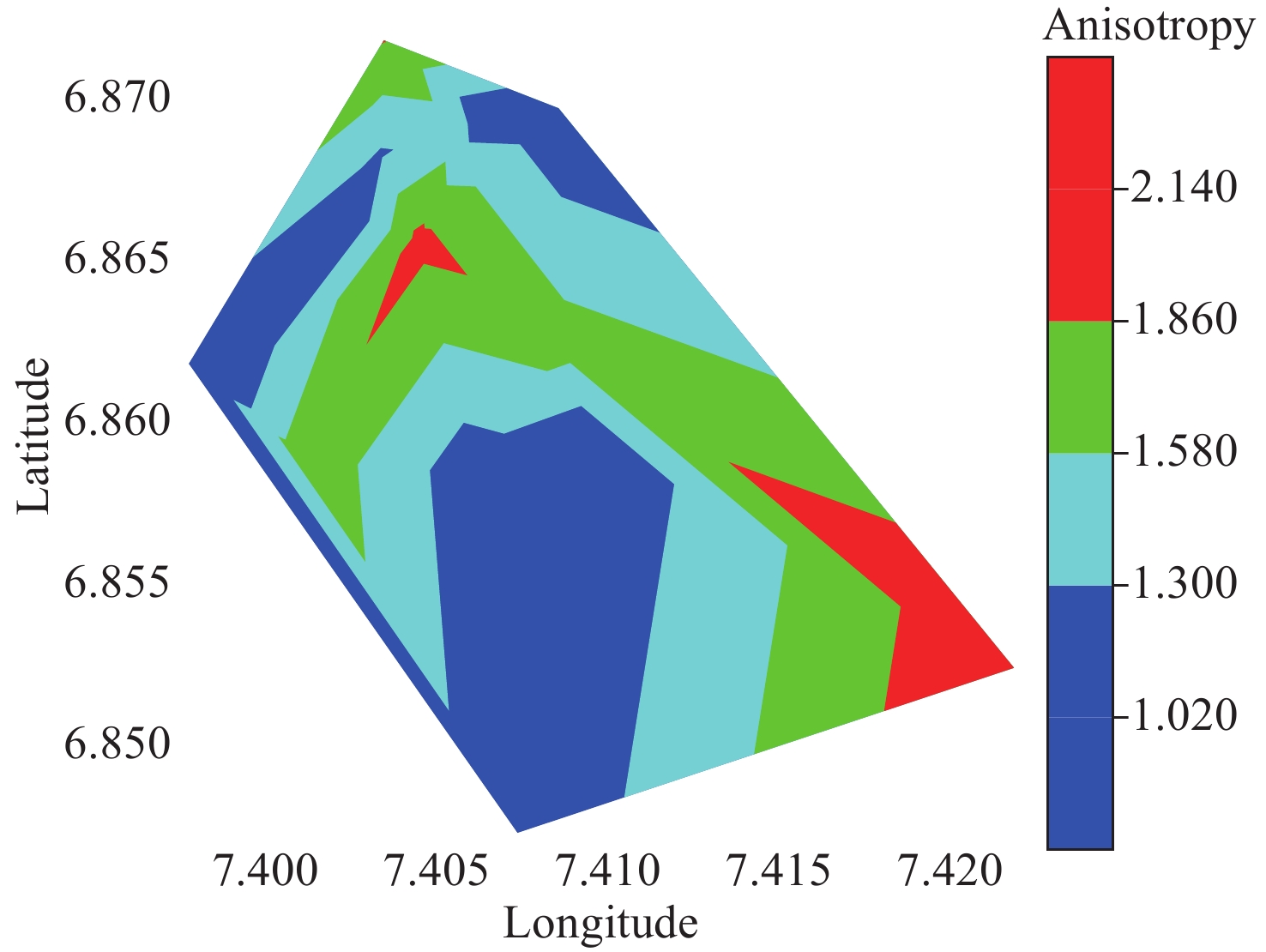
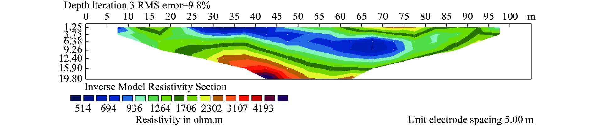
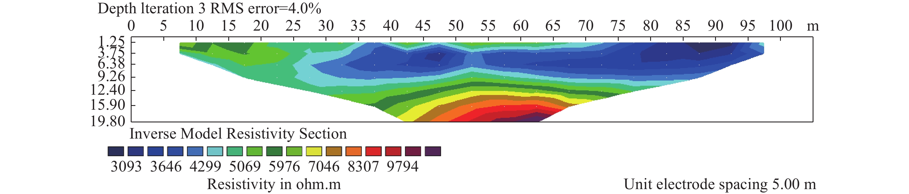
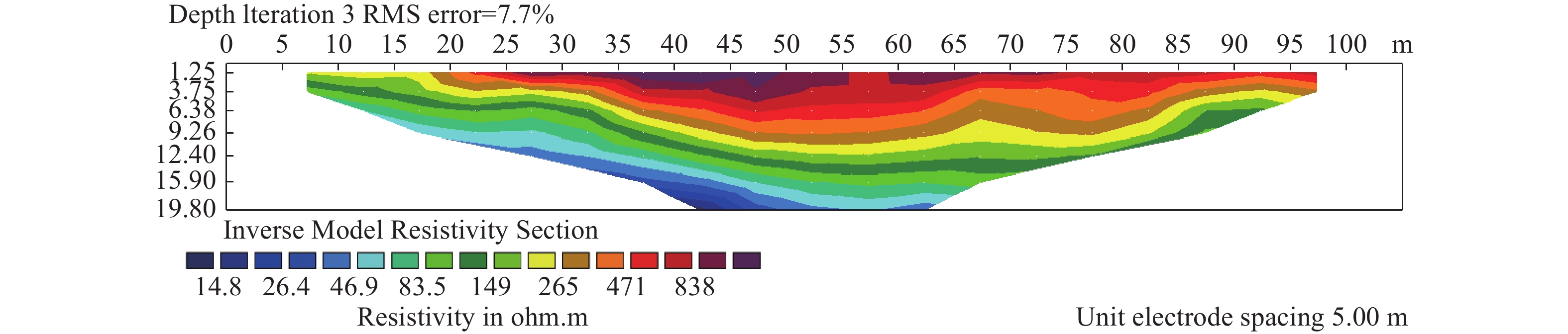
The main objective of the study was to delineate Ground Water Potential Zones (GWPZ) in Mberengwa and Zvishavane districts, Zimbabwe, utilizing geospatial technologies and thematic mapping. Various factors, including geology, soil, rainfall, land use/land cover, drainage density, lineament density, slope, Terrain Ruggedness Index (TRI), and Terrain Wetness Index (TWI), were incorporated as thematic layers. The Multi Influencing Factor (MIF) and Analytical Hierarchical Process (AHP) techniques were employed to assign appropriate weights to these layers based on their relative significance, prioritizing GWPZ mapping. The integration of these weighted layers resulted in the generation of five GWPZ classes: Very high, high, moderate, low, and very low. The MIF method identified 3% of the area as having very high GWPZ, 19% as having high GWPZ, 40% as having moderate GWPZ, 24% as having low GWPZ, and 14% as having very low GWPZ. The AHP method yielded 2% for very high GWPZ, 14% for high GWPZ, 37% for moderate GWPZ, 37% for low GWPZ, and 10% for very low GWPZ. A strong correlation (ρ of 0.91) was observed between the MIF results and groundwater yield. The study successfully identified regions with abundant groundwater, providing valuable target areas for groundwater exploitation and high-volume water harvesting initiatives. Accurate identification of these crucial regions is essential for effective decision-making, planning, and management of groundwater resources to alleviate water shortages.
Influence of water conservancy project on runoff in the source region of the Yellow River and wetland changes in the Lakeside Zone, China
Ming-nan Yang, Liang Zhu, Jing-tao Liu, Yu-xi Zhang, Bing Zhou
2023, 11(4): 333-346. doi: 10.26599/JGSE.2023.9280027
Abstract(178) FullText HTML (85) PDF(110)
Abstract:
The source area of the Yellow River (SAYR), located above the Huangheyan hydrological station, is important for ecological preservation and water source conservation in the Yellow River Basin. In this area, the impact of water conservation projects on the hydrology and the ecological environment is pivotal in protecting water resources and alpine vegetation ecosystems. This study investigates the impact of the Yellow River Source Hydropower Station on the runoff and ecological evolution of the SAYR, along with the underlying mechanism, using extensive datasets encompassing long-term meteorological, hydrological and remote sensing data from various time periods. Results show that, over the long term, precipitation is the primary factor driving runoff variations in the SAYR. Nevertheless, from 1990 to 2020, there is a notably inconsistent relationship between precipitation and runoff. After the completion of the Yellow River Source Hydropower Station in 2001, the water level of Eling Lake experienced and elevation of 2–3 m, leading to a gradual recovery of runoff. In addition, the basin's water balance shifted from a negative to a positive equilibrium, oscillating with changes in lake water levels. Consequently, the overflow zone of the Tangchama alluvial–proluvial fan in the upper reaches of the lakeshore shifted by 500 m, and marsh wetlands expanded by 20.78 km2. The increased storage of lakes and groundwater in the SAYR is the key controlling factor for the runoff recovery, changes in the basin's water balance, and enhancements in lakeshore vegetation ecology. Under the geological background of the Qinghai–Tibet Plateau's upliftment and intensified upstream river erosion, the basin experienced a substantial water imbalance due to declining discharge base levels, which is the most critical factor behind runoff attenuation in the SAYR towards the end of the 20th century. The construction of the hydropower station objectively raised the drainage base level of the basin, thereby positively contributing to the preservation of water balance, runoff stability, and the enhancement of swamps and wetlands along the lakeshore.
Factors driving surface deformations in plain area of eastern Zhengzhou City, China
Zi-jun Zhuo, Dun-yu Lv, Shu-ran Meng, Jian-yu Zhang, Song-bo Liu, Cui-ling Wang
2023, 11(4): 347-364. doi: 10.26599/JGSE.2023.9280028
Abstract(642) FullText HTML (274) PDF(133)
Abstract:
With the rapid socio-economic development and urban expansion, land subsidence has emerged as a major environmental issue, impeding the high-quality development of the plain area in eastern Zhengzhou City, Henan Province, China. However, effective prevention and control of land subsidence in this region have been challenging due to the lack of comprehensive surface deformations monitoring and the quantitative analysis of the factors driving these deformations. In order to accurately identify the dominant factor driving surface deformations in the study area, this study utilized the Persistent Scattered Interferometric Synthetic Aperture Radar (PS-InSAR) technique to acquire the spatio-temporal distribution of surface deformations from January 2018 to March 2020. The acquired data was verified using leveling data. Subsequently, GIS spatial analysis was employed to investigate the responses of surface deformations to the driving factors. The findings are as follows: Finally, the geographical detector model was utilized to quantify the contributions of the driving factors and reveal the mechanisms of their interactions. The findings are as follows: (1) Surface deformations in the study area are dominated by land subsidence, concentrated mainly in Zhongmu County, with a deformation rate of −12.5–−37.1 mm/a. In contrast, areas experiencing surface uplift are primarily located downtown, with deformation rates ranging from 0 mm to 8 mm; (2) Groundwater level, lithology, and urban construction exhibit strong spatial correlations with cumulative deformation amplitude; (3) Groundwater level of the second aquifer group is the primary driver of spatially stratified heterogeneity in surface deformations, with a contributive degree of 0.5328. The contributive degrees of driving factors are significantly enhanced through interactions. Groundwater level and the cohesive soil thickness in the second aquifer group show the strongest interactions in the study area. Their total contributive degree increases to 0.5722 after interactions, establishing them as the primary factors influencing surface deformation patterns in the study area. The results of this study can provide a theoretical basis and scientific support for precise prevention and control measures against land subsidence in the study area, as well as contributing to research on the underlying mechanisms.
Analytical solution for Non-Darcian effect on transient confined-unconfined flow in a confined aquifer
Peng-yu Shi, Jian-jun Liu, Yi-jie Zong, Kai-qing Teng, Yu-ming Huang, Liang Xiao
2023, 11(4): 365-378. doi: 10.26599/JGSE.2023.9280029
Abstract(645) FullText HTML (289) PDF(119)
Abstract:
This paper presents a new analytical solution to investigate the mechanism of transient confined-unconfined flow in a confined aquifer induced by pumping with a large rate during mine drainage. The study focuses on understanding the impact of non-Darcian effect on flow towards a fully penetrated pumping well. The nonlinear relationship between specific discharge and the hydraulic gradient is described using Izbash's equation. A novel approximate method is developed to linearize the mathematical model, and the solution is derived using the Boltzmann transform. The proposed solution is validated by comparing it with previous works. The findings indicate that increased non-Darcian index, quasi-hydraulic conductivity, and specific storage have negatively affect the development of the unconfined region and aquifer drawdown, as greater turbulence flow accelerates recharge to the pumping well. Drawdown is found to be sensitive to the non-Darcian index, quasi-hydraulic conductivity, while it is unaffected by specific yield and specific storage. The conclusions provide valuable insights for mine drainage and the application of geological and hydrological conditions.
Simulation of thermal breakthrough factors affecting carbonate geothermal-to-well systems
Jia-xing Sun, Gao-fan Yue, Wei Zhang
2023, 11(4): 379-390. doi: 10.26599/JGSE.2023.9280030
Abstract(126) FullText HTML (61) PDF(100)
Abstract:
Fractures play a pivotal role in carbonate thermal storage systems, serving as primary hydraulic conductivity channels that significantly influence thermal breakthrough times and heat extraction efficiency in geothermal-to-well systems. Their impact is critical for well placement and system life prediction. This paper focuses on a geothermal-to-well system within the carbonate reservoir of the Wumishan formation in the Rongcheng geothermal field, Xiong'an new area. It employs a combination of field tests and numerical simulations to determine the permeability of the reservoir and the evolution of fractures between wells. It also examines the influence of fracture width and roughness coefficient on the seepage and temperature fields under various injection scenarios and predicts thermal breakthrough times for production wells. The results show: Higher permeability is observed near well D16 compared to well D22 within the studied geothermal-to-well systems. Wider fractures between wells result in faster temperature decline in production wells. Lower injection flow rates lead to slower temperature reduction in injection wells. The use of roughness coefficients minimizes temperature variations in production wells. This study not only offers guidance for the development and utilization of the geothermal well system, but also contributes to a deeper understanding of the groundwater seepage and heat transfer process influenced by fractures.
Effects of coal mining and tunnel excavation on groundwater flow system in karst areas by modeling: A case study in Zhongliang Mountain, Chongqing, Southwest China
Qing-shan Li, Xiao-bing Kang, Mo Xu, Bang-yan Mao
2023, 11(4): 391-407. doi: 10.26599/JGSE.2023.9280031
Abstract(176) FullText HTML (83) PDF(102)
Abstract:
A karst groundwater system ranks among the most sensitive and vulnerable types of groundwater systems. Coal mining and tunnel excavation can greatly change the natural hydrogeological flow system, groundwater-dependent vegetation, soil, as well as hydrology of surface water systems. Abandoned coal mine caves and proposed highway tunnels may have significant influences on groundwater systems. This study employs MODFLOW, a 3D finite-difference groundwater model software, to simulate the groundwater system's response to coal mining and tunnel excavation impact in Zhongliang Mountain, Chongqing, from 1948 to 2035. The results show a regional decline in groundwater levels within the study area following mining and tunnel construction. The groundwater flow system in the study area evolves from the Jialing River groundwater flow system to encompass the Jialing River, Moxinpo highway tunnel, Moxinpo, and the Liujiagou coal mine cave groundwater flow systems between 1948 and 2025. With the completion of tunnel construction, the groundwater level at the top of the tunnel is gradually restored to the water level in the natural state. The model also predicts groundwater level variations between 2025 and 2035. The groundwater level will rise further initially, however, it may take about 10 years for the system to stabilize and reach a new equilibrium. In light of these findings, it is advised that changes in groundwater flow systems caused by tunnel construction should be modeled prior to the practical construction. This approach is crucial for evaluating potential engineering and environmental implications.
Source analysis of dissolved heavy metals in the Shaying River Basin, China
Ya-wei Zhang, Yun-tao Liu, Zi-wen Wang, Yu Cao, Xiao-ran Tu, Di Cao, Shuai Yuan, Xiao-man Cheng, Lian-sheng Zhang
2023, 11(4): 408-421. doi: 10.26599/JGSE.2023.9280032
Abstract(234) FullText HTML (120) PDF(104)
Abstract:
Over the years, the Shaying River Basin has experienced frequent instances of river pollution. The presence of numerous critical pollutant discharge enterprises and sewage-treatment plants in the vicinity of the Shaying River has transformed it a major tributary with relatively serious pollution challenge within the upper reaches of Huaihe River Basin. To study the sources of manganese (Mn), chromium (Cr), nickel (Ni), arsenic (As), cadmium (Cd) and lead (Pb) in Shaying River water, 123 sets of surface water samples were collected from 41 sampling points across the entire basin during three distinct phases from 2019 to 2020, encompassing normal water period, dry season and wet season. The primary origins of heavy metals in river water were determined by analyzing the heavy metal contents in urban sewage wastewater, industrial sewage wastewater, groundwater, mine water, and the heavy metal contributions from agricultural non-point source pollution. The analytical findings reveal that Mn primarily originates from shallow groundwater used for agricultural irrigation, While Cr mainly is primarily sourced from urban sewage treatment plant effluents, coal washing wastewater, tannery wastewater, and industrial discharge related to metal processing and manufacturing. Ni is mainly contributed by urban sewage treatment plant effluents and industrial wastewater streams associated with machinery manufacturing and metal processing. Cd primarily linked to industrial wastewater, particularly from machinery manufacturing and metal processing facilities, while Pb is predominantly associated with urban sewage treatment plant effluents and wastewater generated in Pb processing and recycling wastewater. These research provides a crucial foundation for addressing the prevention and control of dissolved heavy metals at their sources in the Shaying River.
Electrical geophysical evaluation of susceptibility to flooding in University of Nigeria, Nsukka main campus and its environs, Southeastern Nigeria
Daniel Nnaemeka Obiora, Johnson Cletus Ibuot
2023, 11(4): 422-434. doi: 10.26599/JGSE.2023.9280033
Abstract(148) FullText HTML (66) PDF(105)
Abstract:
Flooding occurs when rainfall exceeds the absorption capacity of soil and causes significant environmental consequences. In this study, electrical resistivity techniques were employed to assess the flood susceptibility of the study area by examining variations in electrical properties. Prior to flooding, Vertical Electrical Sounding (VES) and Electrical Resistivity Tomography (ERT) profiles were conducted to determine the variations in resistivity within subsurface lithologies exposed to the injected current. The injected current penetrated the subsurface units characterised by resistivity ranging from 190.5 Ω·m to 6,775.7 Ω·m, 42.3 Ω·m to 7,297.4 Ω·m, and 320.2 Ω·m to 24,433.3 Ω·m in the first, second and third layers, respectively. These layers were identified as lateritic topsoil, medium-coarse brownish grained sand, and coarse pebbly blackish sand, respectively. The calculated reflection coefficients between layers 1, 2, and 3 reveal alternation in layers with values ranging from −0.04 to 0.66 and 0.36 to 0.95 for $ {k}_{1} $ and $ {k}_{2} $, respectively. The transverse resistivity, longitudinal resistivity and anisotropy ranged from 243.59 Ω·m to 24,115.42 Ω·m, 199.61 Ω·m to 14,950.76 Ω·m, and 1.02 to 2.14. Models derived from the ERT profiles reveal variations in resistivity, pinpointing areas of low resistivity which correspond to waterlogged and impermeable layers. The result of this study underscores the importance of integrated resistivity techniques in the study of floods, as it provides valuable insights into flood behaviour, and subsurface dynamics.

Welcome to Journal of Groundwater Science and  Engineering!

Quick Submit

Online Submission   E-mail Submission