 E-mail alert
 Rss
Rss



Uncertainty analysis of elevation data based on groundwater modeling system: A case study of Zhaozhou County, China
-
Abstract: This study takes Zhaozhou County in the Songnen Plain (a plain area with sparse borehole data) as the study area, and aims to address the issue of elevation data sources' impact on groundwater numerical simulation by comparatively analyzing the application effects of the Shuttle Radar Topography Mission Digital Elevation Model 90M (SRTM DEM 90M) and interpolated elevation derived from 25 actual boreholes and 14 virtual boreholes (synthetic borehole points derived from DEM data and corrected using nearby measured boreholes). The results show that: The elevation of SRTM DEM 90M can reflect regional microtopographic features; borehole interpolation has single-point errors (−5 m to 10 m) and interpolation uncertainty, and the over-smoothed terrain leads to a relative deviation of 40%–50% in unsaturated zone thickness in specific areas, which further results in a maximum reduction of 93% in evaporation (from 93.92 m3/d to 6.34 m3/d). Regarding simulation accuracy, the traditional water level dynamic fitting of both models meets the required standards, but the Nash-Sutcliffe Efficiency (NSE) value of water level fitting for the borehole model is negative, while the statistical indicators of the SRTM model meet the standards. This study confirms that: (1) the "parameter combination effect" plays a dominant role in simulation: Simulation results are essentially the integrated product of multi-parameter interaction; (2) in borehole-sparse areas similar to the Songnen Plain, SRTM DEM 90M can replace borehole interpolation.
-
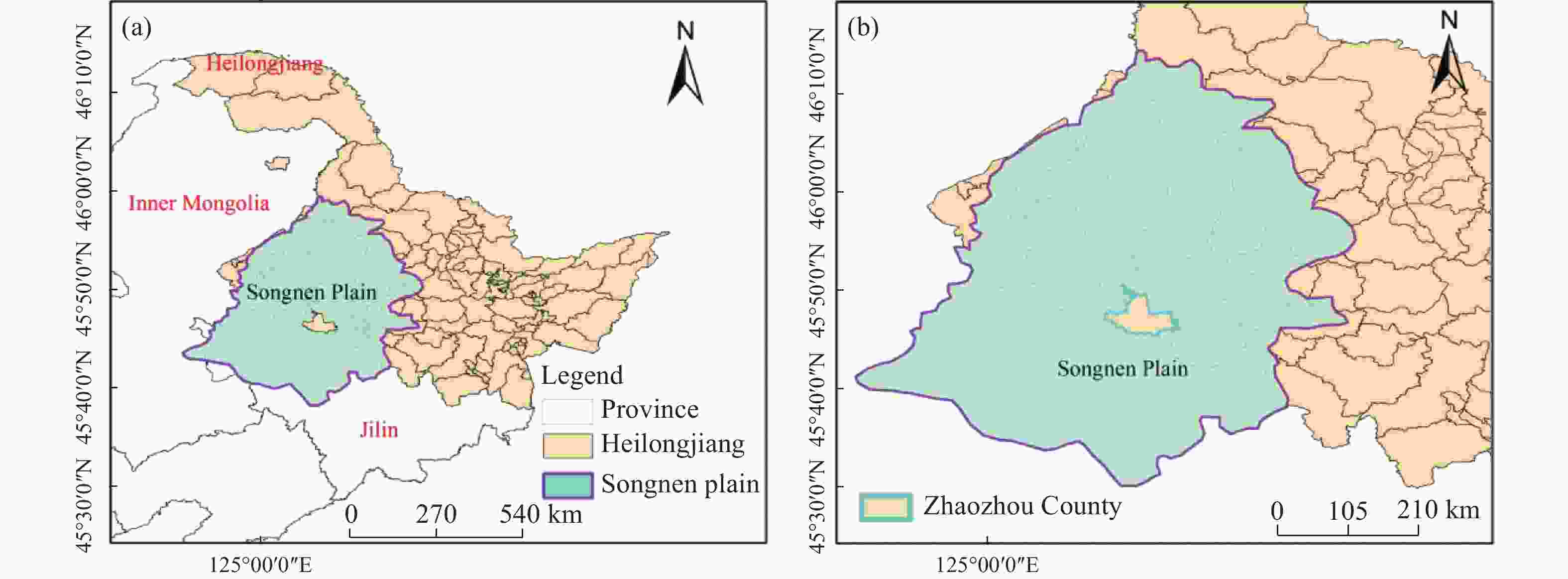
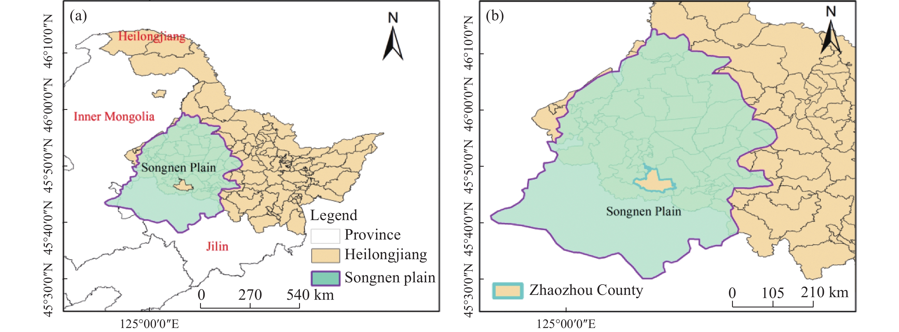
Figure 1. Geographical map of the study area. (a) geographical location of the Songnen Plain and provincial administrative boundaries; (b) location of Zhaozhou County (the study area) within the Songnen Plain
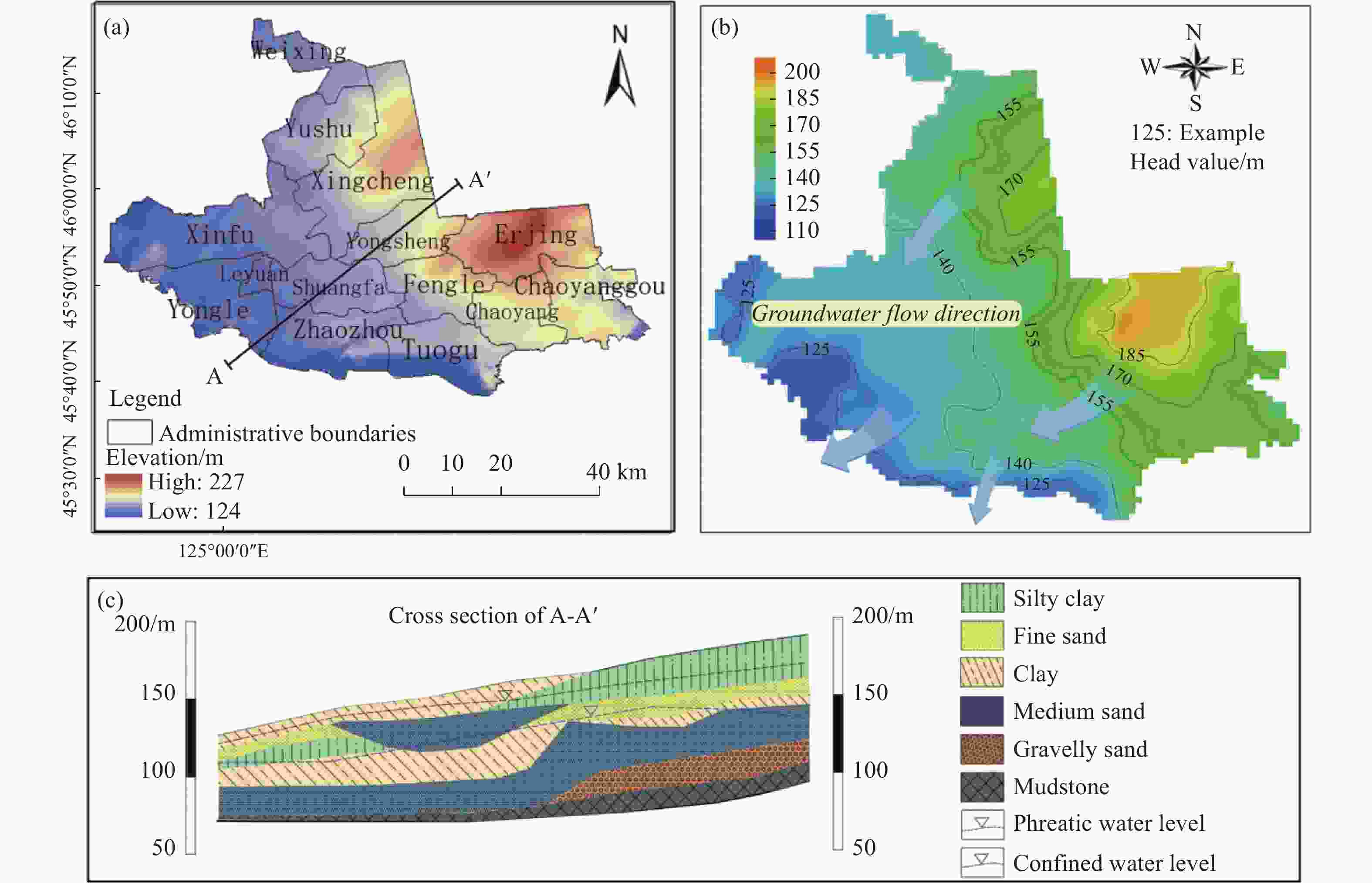
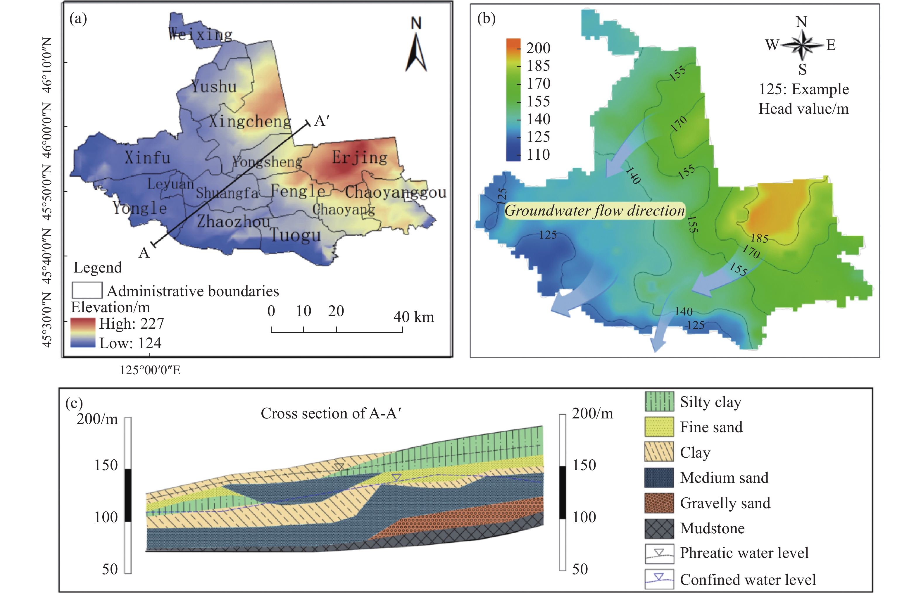
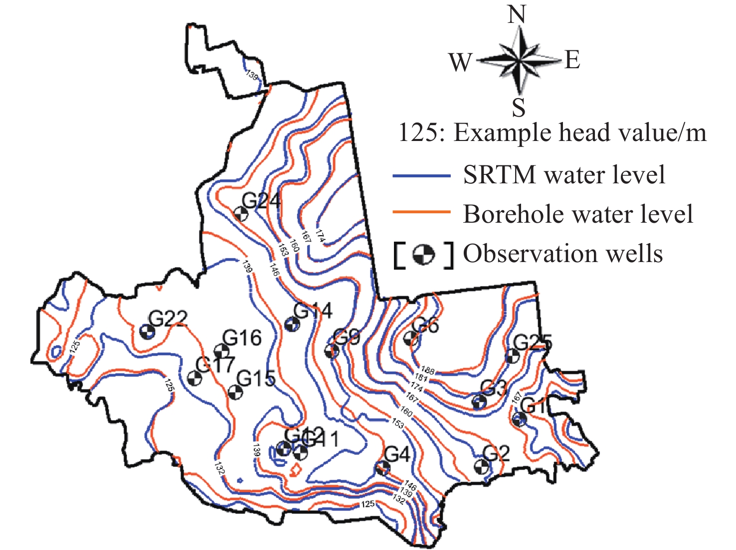
Figure 2. The information on topographic elevation, township distribution, groundwater flow direction, and A-A' hydrogeological profile of the study area. (a) topographic elevation and township distribution; (b) groundwater flow direction; (c) A-A' hydrogeological profile
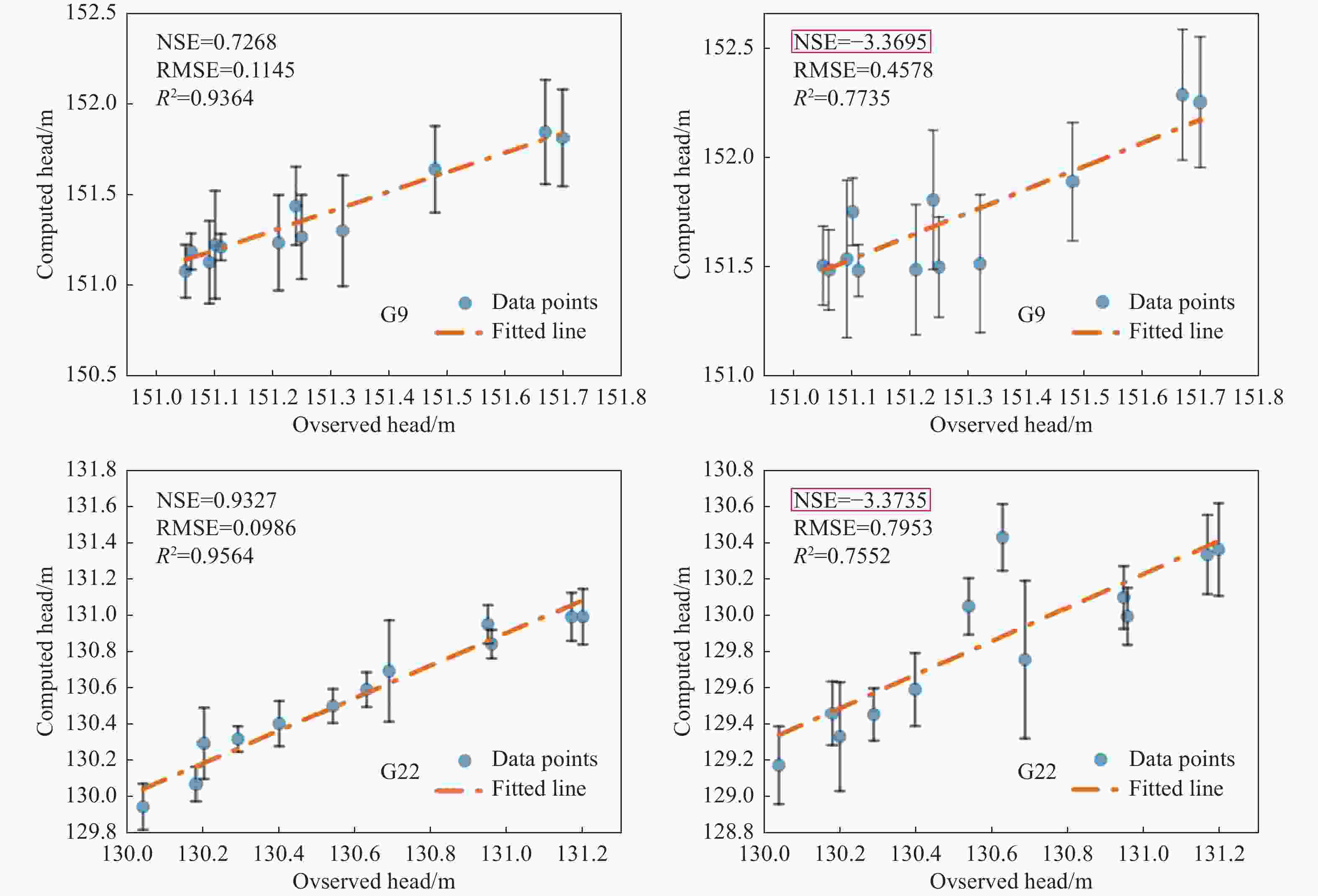
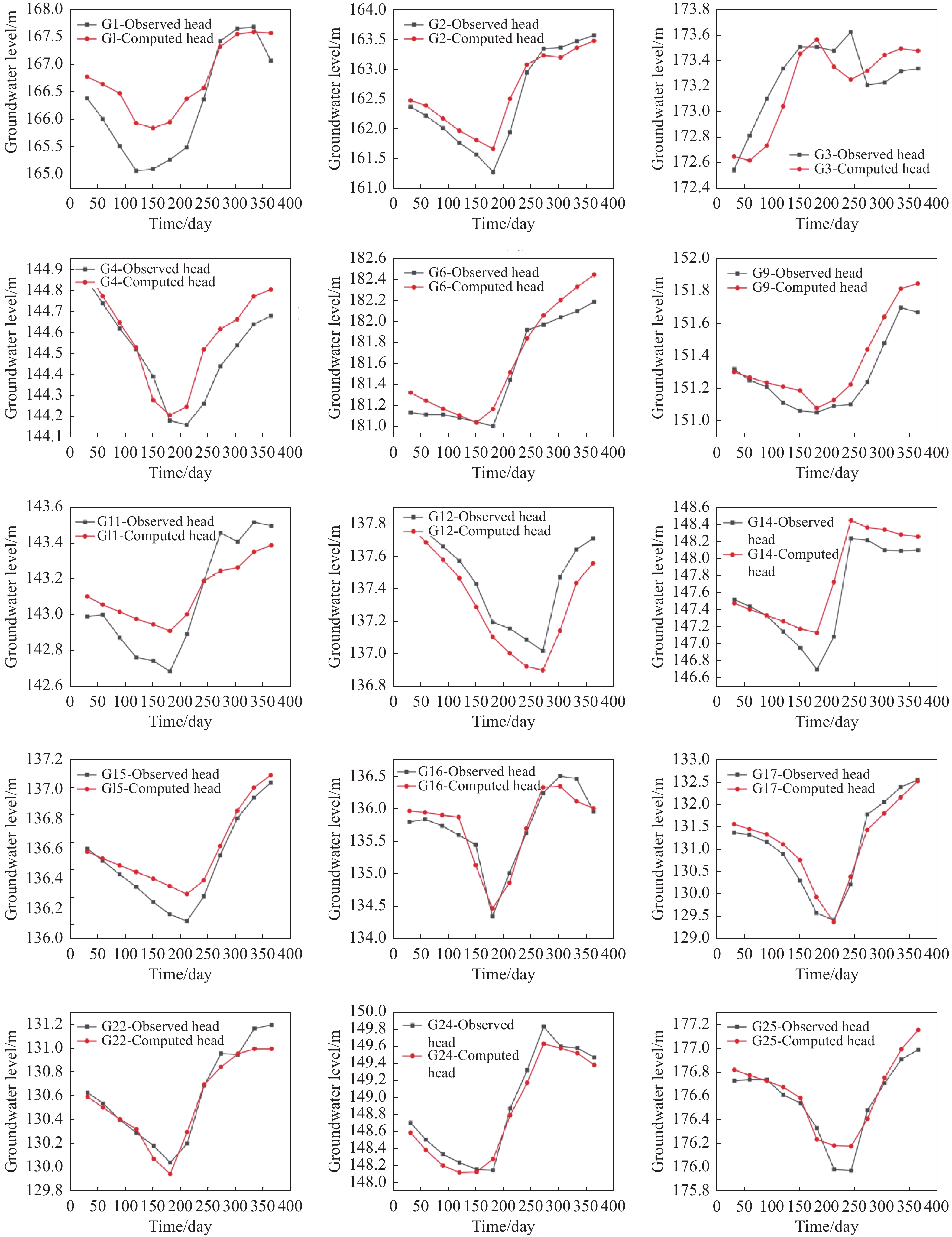
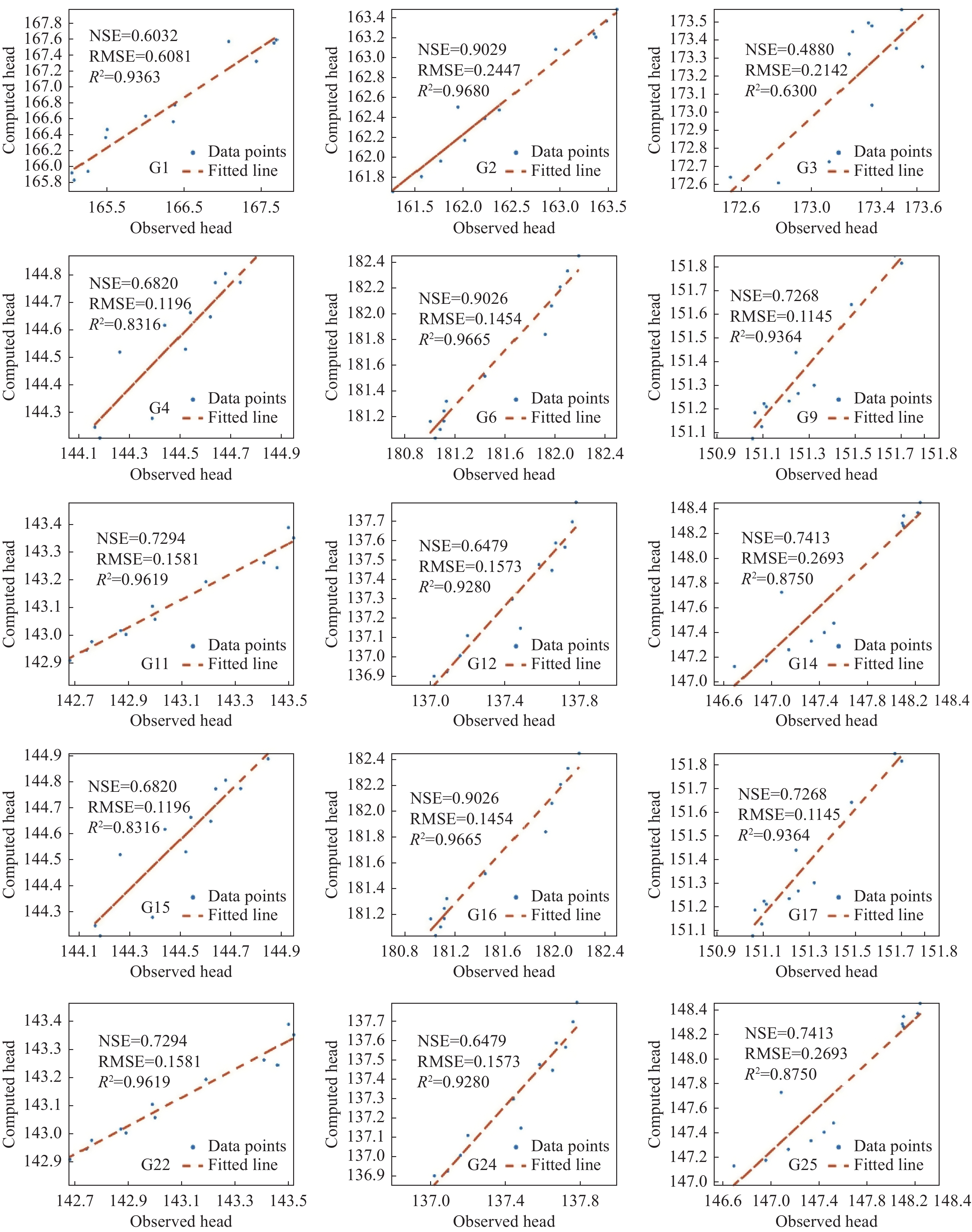
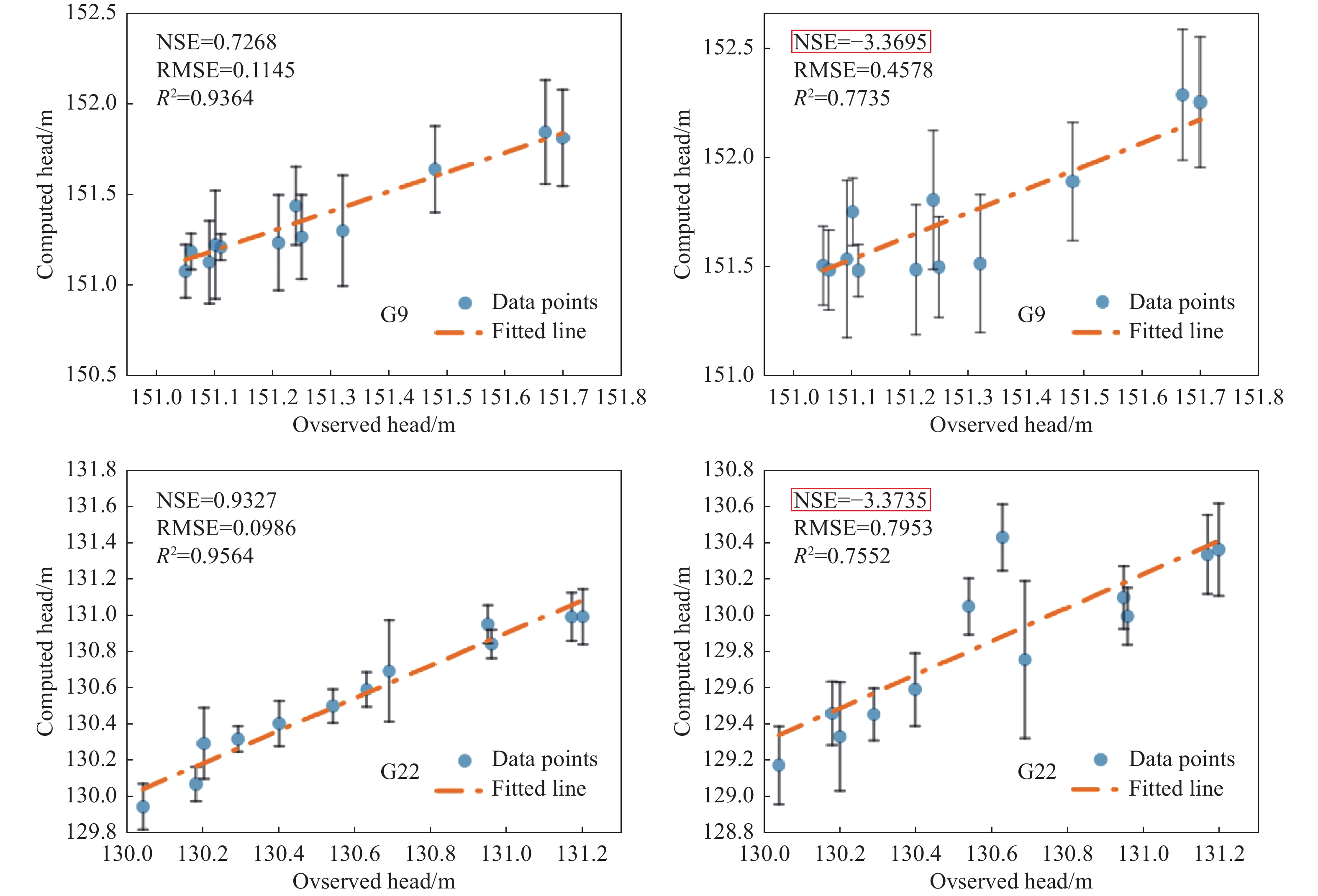
Figure 15. Statistical indicator comparison chart (left - SRTM DEM, right - Borehole elevation)
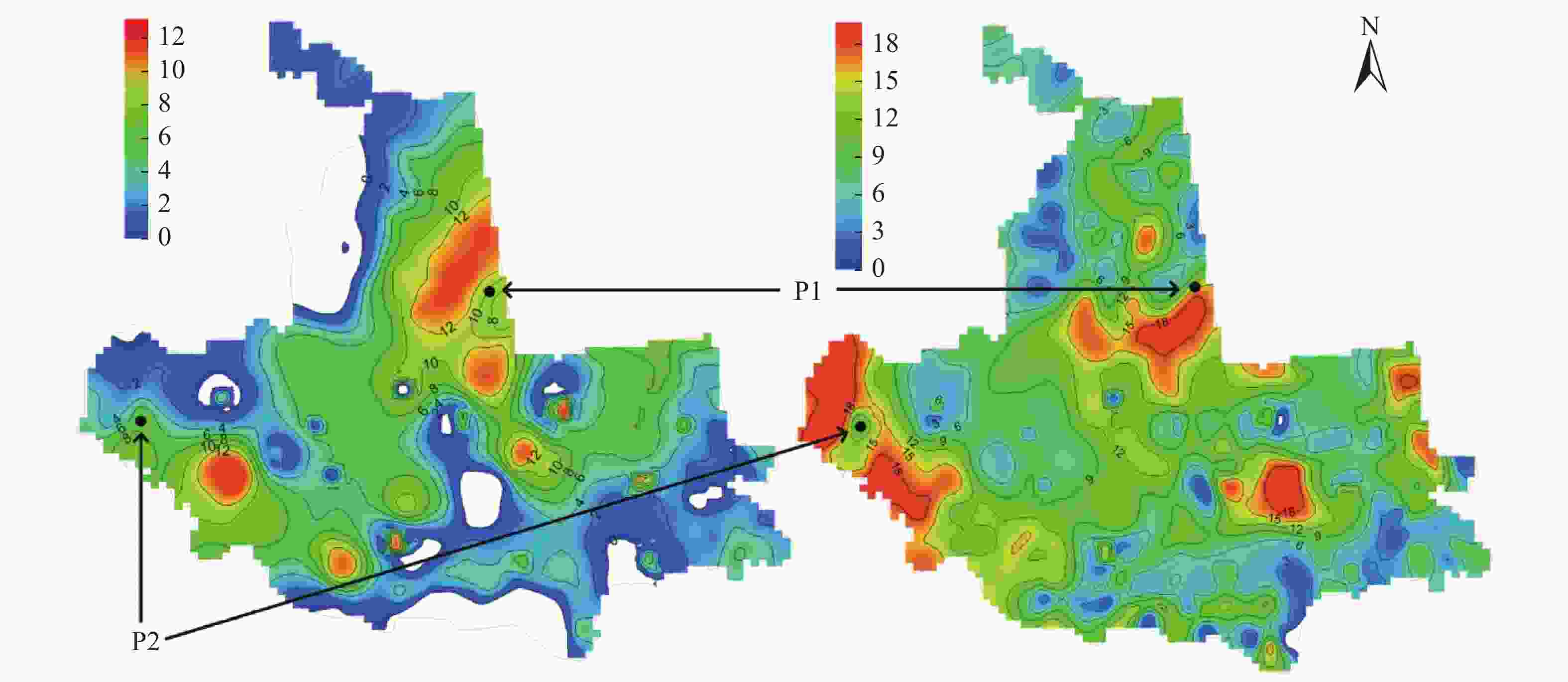
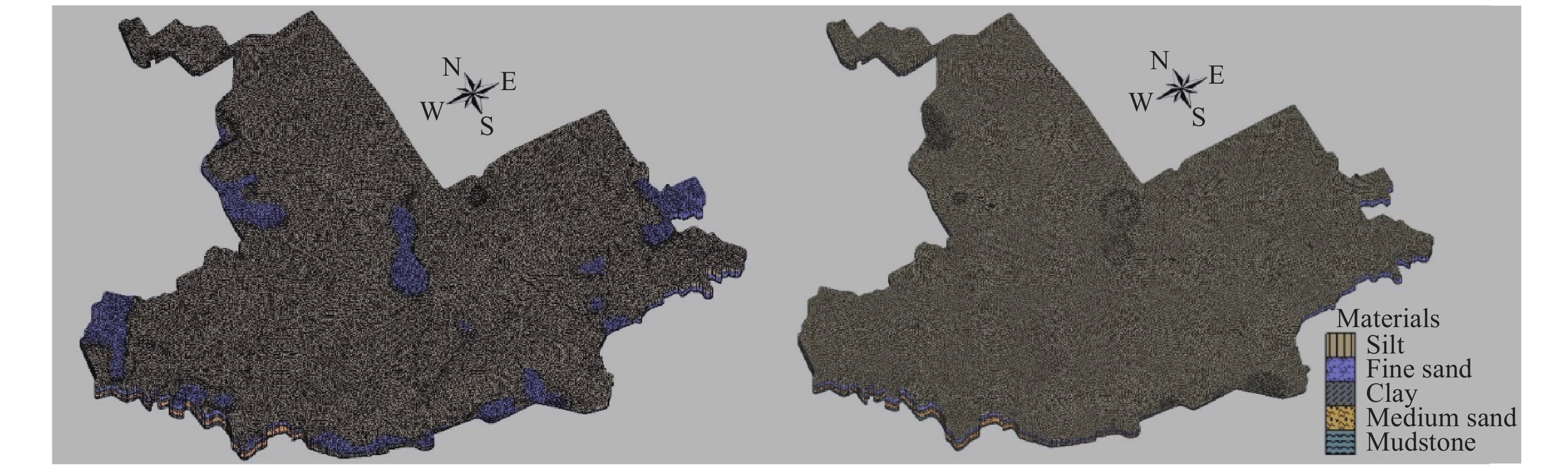
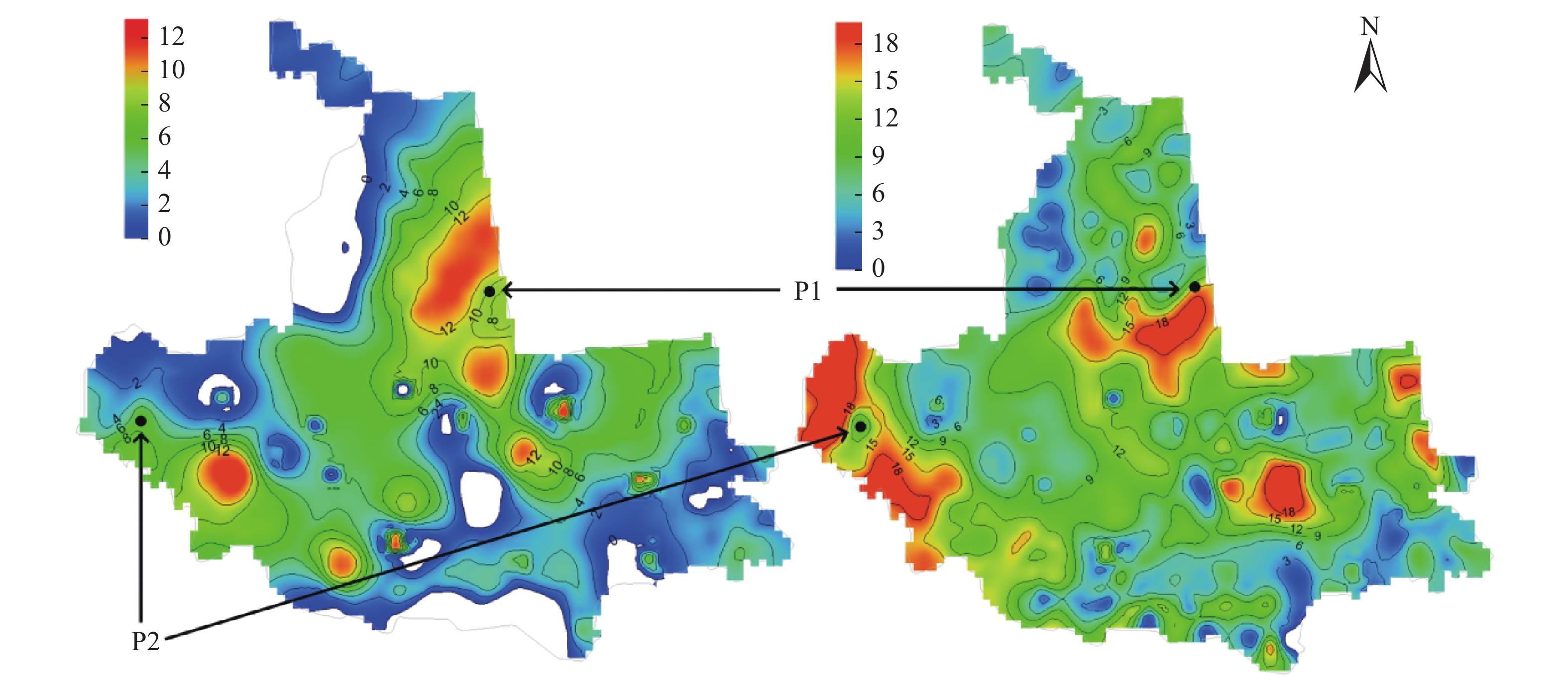
Figure 16. Comparison of spatial distribution of unsaturated zone thickness (left - SRTM DEM, right - Borehole elevation).
Table 1. Hydraulic parameters values
Type of aquifer Parameter partitioning Kh (m/d) Kv (m/d) Sy Ss (1/m) Effective porosity Unconfined aquifer Ⅰ 4 0.4 0.1 0.3 Ⅱ-Ⅳ 6 0.6 0.1 0.3 Ⅴ 8 0.8 0.1 0.3 Aquitard 0.001 0.0001 0.000001 0.3 Notes: The starting head in the model uses the water level data observed in the observation wells on January 1,2012.  下载: 导出CSV
Table 2. Monthly rainfall and evaporation in 2012
Month 1 2 3 4 5 6 7 8 9 10 11 12 Rainfall (mm) 0.1 1.6 11.6 27.9 11.7 99.9 118.4 48.5 68.6 36.2 31.6 9.8 Evaporation (mm) 11.8 27 91.1 228.3 320.1 270 213.7 177.2 148.2 112.2 43.1 16.5
下载: 导出CSV
Table 3. Agricultural irrigation volume
Township Area (km2) Irrigation volume (104 m3) Recharge rate (m/d) Shuangfa Township 145.52 151.7 0.000011 Tuogu Township 184.07 166.9 0.0000096 Zhaozhou Town 200.51 390.7 0.0000206 Yongle Town 175.88 185.6 0.0000112 Xinfu Township 358.79 333.1 0.0000098 Xingcheng Town 340.54 287.8 0.0000089 Fengle Town 132.2 174.7 0.000014 Yongsheng Township 136.03 164.7 0.0000128 Yushu Township 184.28 186.5 0.0000107 Chaoyanggou Town 156.05 189.7 0.0000128 Chaoyang Township 131.64 147.8 0.0000119 Erjing Town 230.37 297.7 0.0000137 Weixing Breeding Farm 85.06 60.1 0.0000075 Le Yuan Township 25.26 22.9 0.0000096
下载: 导出CSV
Table 4. Main coefficients for the study area
Study area/km2 Rainfall infiltration recharge factor Irrigation infiltration recharge factor Soil evaporation coefficient 2,445 0.189 0.13 0.042
下载: 导出CSV
Table 5. Hydrogeological parameter calibration results
Parameter
partitioningHydraulic
conductivity (m/d)Specific
yieldⅠ 4.57 0.06 Ⅱ 6.35 0.08 Ⅲ 7.64 0.12 Ⅳ 6.42 0.09 Ⅴ 8.95 0.14
下载: 导出CSV
Table 6. Ⅵ and Ⅶ, hydrological parameter calibration results
Parameter
partitioningHydraulic
conductivity (m/d)Specific yield Ⅵ 7.94 0.11 Ⅶ 7.89 0.11
下载: 导出CSV
Table 7. Basis for the layout of virtual boreholes
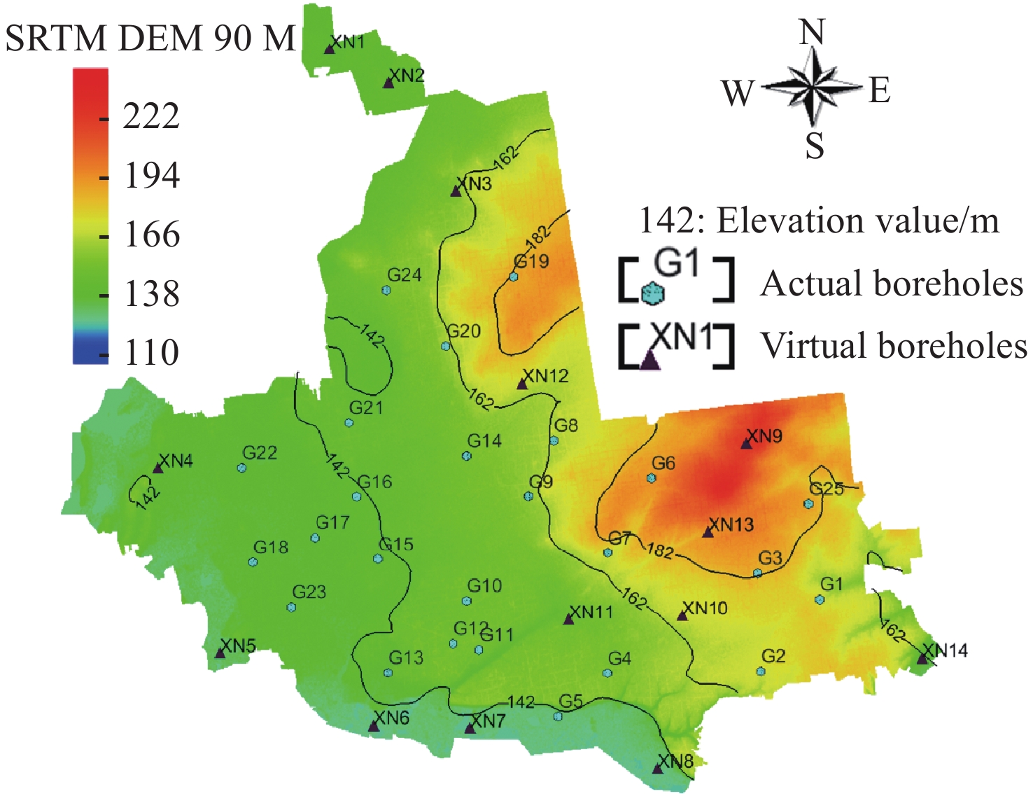
Type Virtual borehole numbering Information gap areas XN1, XN2, XN3, XN4, XN11 Areas with high topographic gradient (areas with distinct color transitions in Fig. 12) XN9, XN10, XN12, XN13 Boundary areas of the study area XN5, XN6, XN7, XN8, XN14
下载: 导出CSV
Table 8. Hydrogeological parameter data
Parameter
partitioningHydraulic
conductivity (m/d)Specific yield Ⅰ 2.46 0.06 Ⅱ 4.88 0.07 Ⅲ 5.45 0.11 Ⅳ 5.31 0.08 Ⅴ 6.87 0.12
下载: 导出CSV
Table 9. Analysis of unsaturated zone thickness
Position SRTM DEM thickness (m) Borehole model thickness (m) Relative deviation (%) Northeast P1 8.2 12.3 50.0 Western P2 6.5 9.1 40.0
下载: 导出CSV
Table 10. Variation of ET flow out with unsaturated zone thickness
Type Values Unsaturated zone thickness (m) 6.5 8 9 9.1 10 ET Flow Out (m3/d) 93.92 30.68 7.14 6.34 0
下载: 导出CSV
Table 11. Comparison of lithology-hydraulic parameters of G9 unsaturated zone
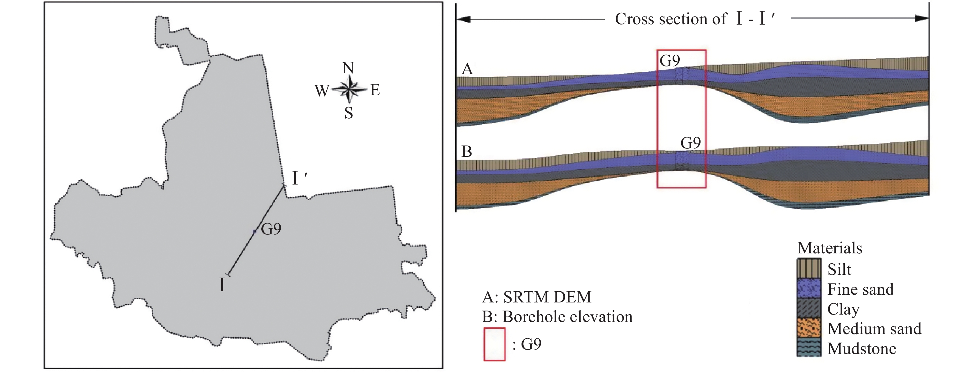
Type SRTM DEM model Borehole elevation model Lithology of unsaturated zone Fine sand Silt, fine sand Hydraulic conductivity (m/d) 7.64 5.45
下载: 导出CSV
-
Al-Areedhi HH. 2019. Modelling of groundwater flow for the Iraqi Aquifers. Ph. D. Thesis, Iraq: University of Technology. Beven K. 1989. Changing ideas in hydrology — The case of physically-based models. Journal of Hydrology, 105(1-2): 157−172. DOI: 10.1016/0022-1694(89)90101-7. Baalousha HM. 2012. Modelling surface-groundwater interaction in the Ruataniwha basin, Hawke's Bay, New Zealand. Environmental Earth Sciences, 66: 285−294. DOI: 10.1007/s12665-011-1238-y. Borgia A, Cattaneo L, Marconi D, et al. 2011. Using a MODFLOW grid, generated with GMS, to solve a transport problem with TOUGH2 in complex geological environments: The intertidal deposits of the Venetian Lagoon. Computers & Geosciences, 37(6): 783−790. DOI: 10.1016/j.cageo.2010.11.007. Chen Z, Huang JT, Zhan HB, et al. 2022. Optimization schemes for deep foundation pit dewatering under complicated hydrogeological conditions using MODFLOW-USG. Engineering Geology, 303: 106653. DOI: 10.1016/j.enggeo.2022.106653. Chepkemoi A, Home PG, Raude JM, et al. 2023. Modeling of groundwater potential in Kericho County, Kenya, using GMS_MODFLOW. Scientific African, 19: e01492. DOI: 10.1016/j.sciaf.2022.e01492. Cromwell G, Sweetkind DS, Densmore JN, et al. 2022. Hydrogeologic characterization of the San Antonio Creek Valley watershed, Santa Barbara County, California. Scientific Investigations Report 2022-5001, Groundwater Availability and Use Assessments. US Geological Survey. DOI: 10.3133/sir20225001. Enemark T, Madsen RB, Sonnenborg TO, et al. 2024. Incorporating interpretation uncertainties from deterministic 3D hydrostratigraphic models in groundwater models. Hydrology and Earth System Sciences, 28: 505−523. DOI: 10.5194/hess-28-505-2024. Gaaloul N. 2008. Integrated management of the ground water resources a case study in the Cap-Bon plain in Tunisia. La Houille Blanche, 94(5): 38−44. DOI: 10.1051/lhb:2008052. Gao YH, Shen JH, Chen L, et al. 2023. Influence of underground space development mode on the groundwater flow field in Xiong'an new area. Journal of Groundwater Science and Engineering, 11: 68−80. DOI: 10.26599/jgse.2023.9280007. He YJ, Wang YY, Liu Y, et al. 2024. Focus on the nonlinear infiltration process in deep vadose zone. Earth-Science Reviews, 252: 104719. DOI: 10.1016/j.earscirev.2024.104719. Hunt RJ, Doherty J, Tonkin MJ. 2007. Are models too simple? Arguments for increased parameterization. Ground water, 45(3): 254−262. DOI: 10.1111/j.1745-6584.2007.00316.x. Harbaugh AW. 2005. MODFLOW-2005: The U. S. Geological Survey modular ground-water model--the ground-water flow process. Techniques and Methods 6-A16. DOI: 10.3133/tm6A16. Høyer AS, Jørgensen F, Sandersen PBE, et al. 2015. 3D geological modelling of a complex buried-valley network delineated from borehole and AEM data. Journal of Applied Geophysics, 122: 94−102. DOI: 10.1016/j.jappgeo.2015.09.004. Konikow LF, Bredehoeft JD. 1992. Ground-water models cannot be validated. Advances in Water Resources, 15: 75−83. DOI: 10.1016/0309-1708(92)90033-X. Kawo NS, Korus J, Gulbrandsen ML. 2023. Multiple-point statistical modeling of three-dimensional glacial aquifer heterogeneity for improved groundwater management. Hydrogeology Journal, 31: 1525−1546. DOI: 10.1007/s10040-023-02658-x. Kheirandish M, Rahimi H, Kamaliardakani M, et al. 2020. Obtaining the effect of sewage network on groundwater quality using MT3DMS code: Case study on Bojnourd plain. Groundwater for Sustainable Development, 11: 100439. DOI: 10.1016/j.gsd.2020.100439. Korus JT, Joeckel RM. 2022. Sandstone-body geometry and hydrostratigraphy of the northern High Plains Aquifer system, USA. Quarterly Journal of Engineering Geology and Hydrogeology, 55: 18. DOI: 10.1144/qjegh2021-171. Langevin CD, Provost AM, Panday S, et al. 2022. Documentation for the MODFLOW 6 Groundwater Transport Model. DOI: 10.3133/tm6A61. Li ZX, Xiao J, Wan JW, et al. 2024. A dynamic modeling approach to predict water inflow during tunnel excavation in relatively uniform rock masses. Tunnelling and Underground Space Technology, 146: 105568. DOI: 10.1016/j.tust.2024.105668. Lyazidi R, Hessane MA, Moutei JF, et al. 2020. Developing a methodology for estimating the groundwater levels of coastal aquifers in the Gareb-Bourag plains, Morocco embedding the visual MODFLOW techniques in groundwater modeling system. Groundwater for Sustainable Development, 11: 100471. DOI: 10.1016/j.gsd.2020.100471. Mcdonald MG, Harbaugh AW. 1988. A modular three-dimensional finite difference groundwater flow model. Niswonger RG, Allander KK, Jeton AE. 2014. Collaborative modelling and integrated decision support system analysis of a developed terminal lake basin. Journal of Hydrology, 517: 521−537. DOI: 10.1016/j.jhydrol.2014.05.043. Panday S, Langevin CD, Niswonger RG, et al. 2013. MODFLOW–USG version 1: An unstructured grid version of MODFLOW for simulating groundwater flow and tightly coupled processes using a control volume finite-difference formulation.Techniques and Methods 6-A45. DOI: 10.3133/tm6A45. Qiu SW, Liang XJ, Xiao CL, et al. 2015. Numerical simulation of groundwater flow in a river valley basin in Jilin Urban Area, China. Water, 7: 5768−5787. DOI: 10.3390/w7105768. Sahu SK, Jhariya DC. 2023. 3D-Mathematical model to simulate groundwater flow and sulfate concentration in Tantaria watershed, Bemetara district, Chhattisgarh, India. Environment Development and Sustainability, 25: 1667−1683. DOI: 10.1007/s10668-022-02115-x. Wellmann F, Caumon G. 2018. 3-D Structural geological models: Concepts, methods, and uncertainties. In: SCHMELZBACH, C. (ed.) Advances in Geophysics, 59. San Diego: Elsevier Academic Press Inc. Woolfenden LR, Engott JA, Larsen J, et al. 2022. Simulation of groundwater and surface-water resources of the San Antonio Creek Valley watershed, Santa Barbara County, California. US Geological Survey. DOI: 10.3133/sir20215139. Yang FR, Lee CH, Kung WJ, et al. 2009. The impact of tunneling construction on the hydrogeological environment of "Tseng-Wen Reservoir Transbasin Diversion Project" in Taiwan. Engineering Geology, 103: 39−58. DOI: 10.1016/j.enggeo.2008.07.012. Zangeneh M, Tabrizi MS, Khosrojerdi A, et al. 2023. Developing a decision-making model for improving the groundwater balance to control land subsidence. Soil and Water Research, 18: 55−65. DOI: 10.17221/57/2022-swr. Zhai HT, Wang JC, Lu YC, et al. 2023. Prediction of the mine water inflow of coal-bearing rock series based on well group pumping. Water, 15(20): 3680. DOI: 10.3390/w15203680. Zhang Q, Yang QK, Cheng J, et al. 2018. Characteristics of 3" SRTM Errors in China. Geomatics and Information Science of Wuhan University, 43(05): 684−690. (in Chinese) DOI: 10.13203/j.whugis20160347. -

 点击查看大图
计量
- 文章访问数: 11
- HTML全文浏览量: 4
- PDF下载量: 0
- 被引次数: 0


