 E-mail alert
 Rss
Rss

Vulnerability assessment in fractured aquifer using improved vulnerability index: Applied to Gabes aquifer, Southeastern Tunisia
-
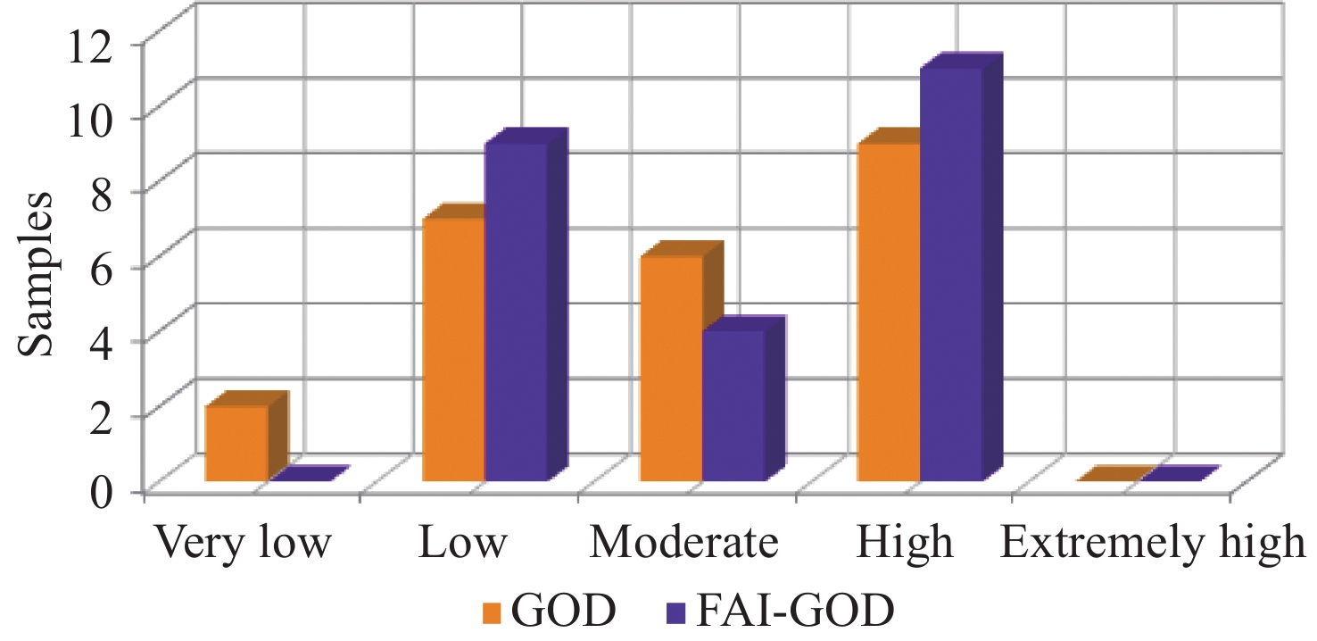
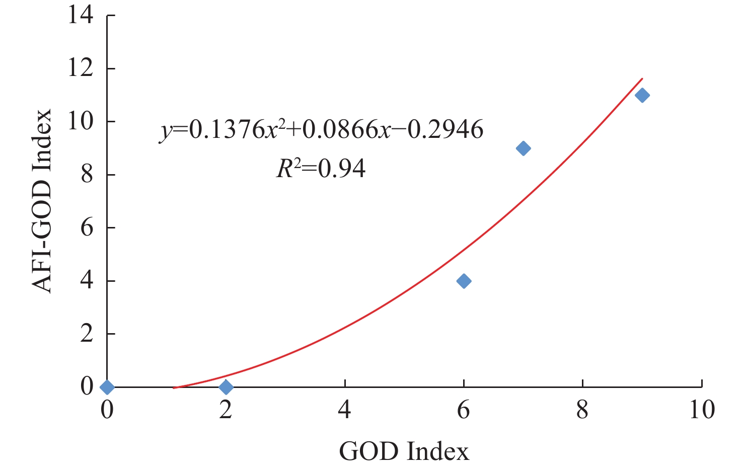
Abstract: The Gabes aquifer system, located in southeastern Tunisia, is a crucial resource for supporting local socio-economic activities. Due to its dual porosity structure, is particularly vulnerable to pollution. This study aims to develop a hybrid model that combines the Fracture Aquifer Index (FAI) with the conventional GOD (Groundwater occurrence, Overall lithology, Depth to water table) method, to assess groundwater vulnerability in fractured aquifer. To develop the hybrid model, the classical GOD method was integrated with FAI to produce a single composite index. Each parameter within both GOD and FAI was scored, and a final index was calculated to delineate vulnerable areas. The results show that the study area can be classified into four vulnerability levels: Very low, low, moderate, and high, indicating that approximately 8% of the area exhibits very low vulnerability, 29% has low vulnerability, 25% falls into the moderate category, and 38% is considered highly vulnerable. The FAI-GOD model further incorporates fracture network characteristics. This refinement reduces the classification to three vulnerability classes: Low, medium, and high. The outcomes demonstrate that 46% of the area is highly vulnerable due to a dense concentration of fractures, while 17% represents an intermediate zone characterized by either shallow or deeper fractures. In contrast, 37% corresponds to areas with lightly fractured rock, where the impact on vulnerability is minimal. Multivariate statistical analysis was employed using Principal Components Analysis (PCA) and Hierarchical Cluster Analysis (HCA) on 24 samples across six variables. The first three components account for over 76% of the total variance, reinforcing the significance of fracture dynamics in classifying vulnerability levels. The FAI-GOD model removes the very-low-vulnerability class and expands the spatial extent of low- and high-vulnerability zones, reflecting the dominant influence of fracture networks on aquifer sensitivity. While both indices use a five-class system, FAI-GOD redistributes vulnerability by eliminating very-low-vulnerability areas and amplifying low/high categories, highlighting the critical role of fractures. A strong correlation (R2 = 0.94) between the GOD and FAI-GOD indices, demonstrated through second-order polynomial regression, confirms the robustness of the FAI-GOD model in accurately predicting vulnerability to pollution. This model provides a useful framework for assessing the vulnerability of complex aquifers and serves as a decision-making tool for groundwater managers in similar areas.
-
Key words:
- Groundwater /
- Aquifer vulnerability /
- Fractured media /
- FAI-GOD index /
- GOD index /
- GIS
-

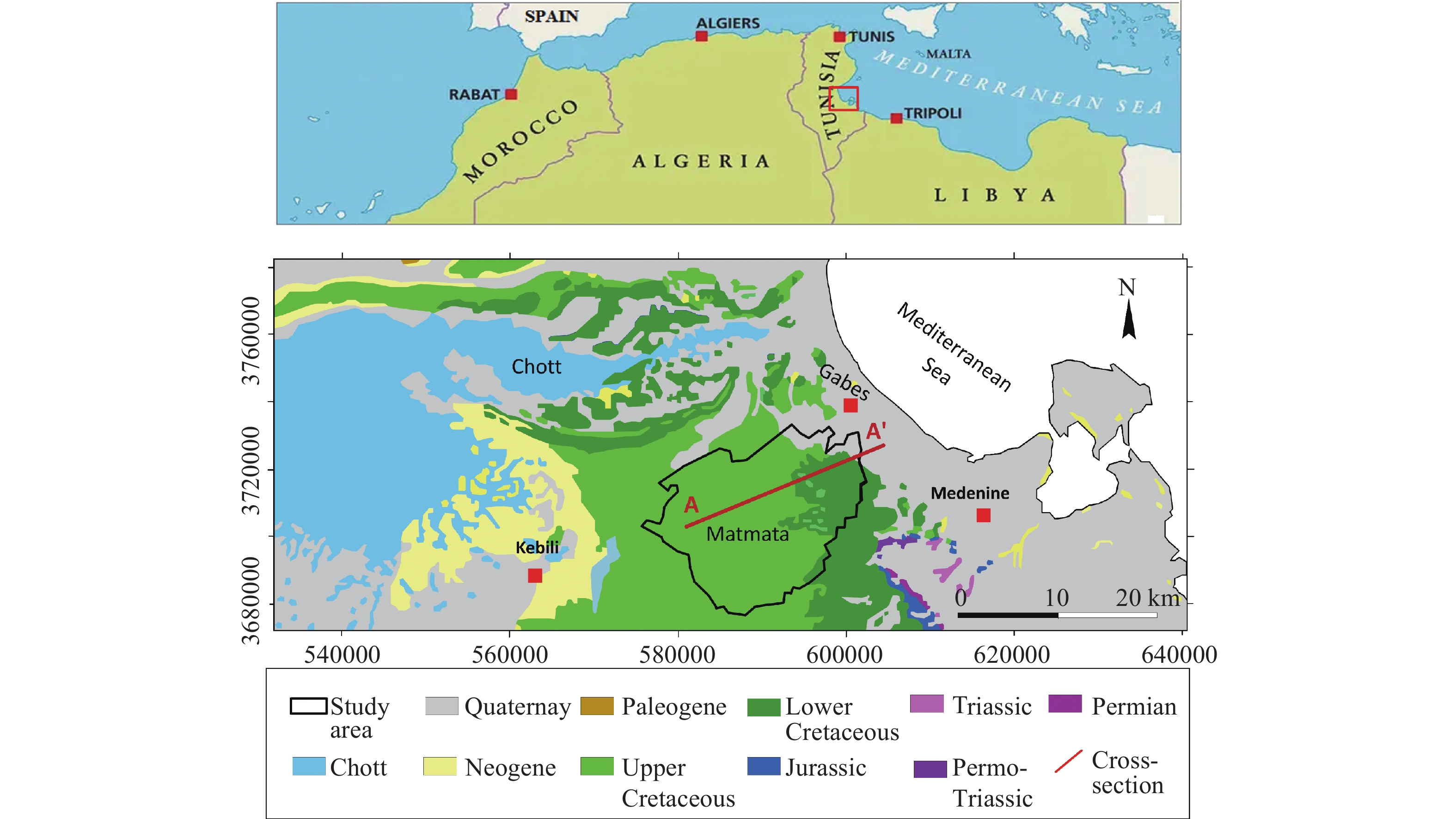
Figure 1. Location and geological map of the study area (Based on Tunisia geological map 1/500,000)

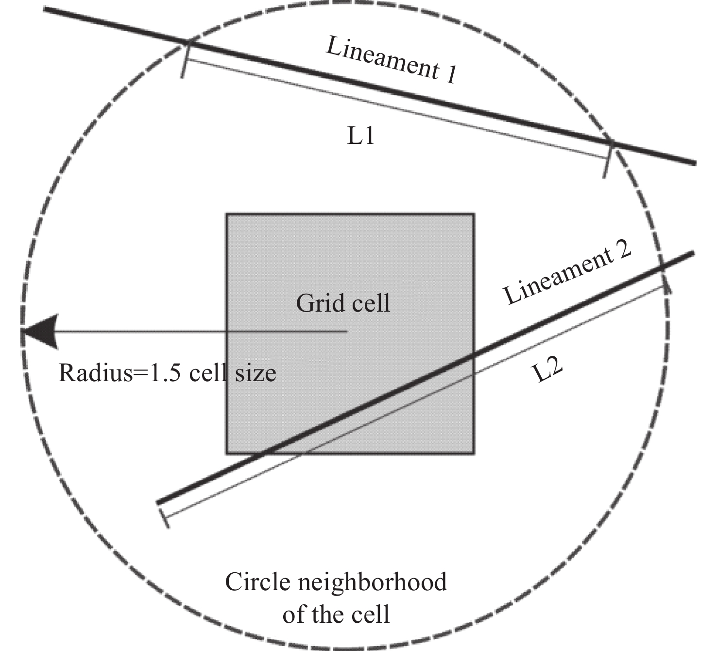
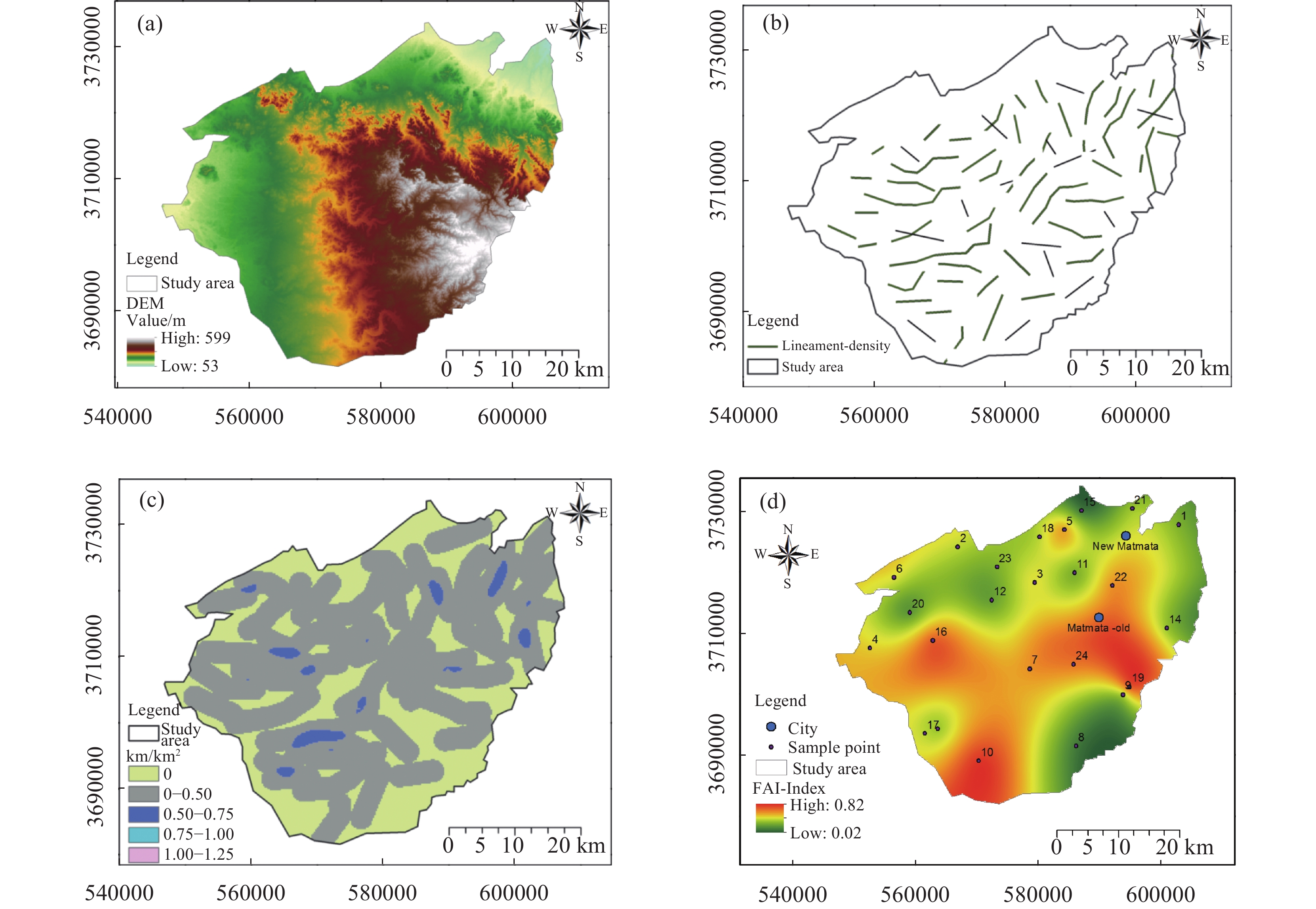
Figure 4. Lineament density illustration using ArcGIS functions (after Tam et al. 2004)

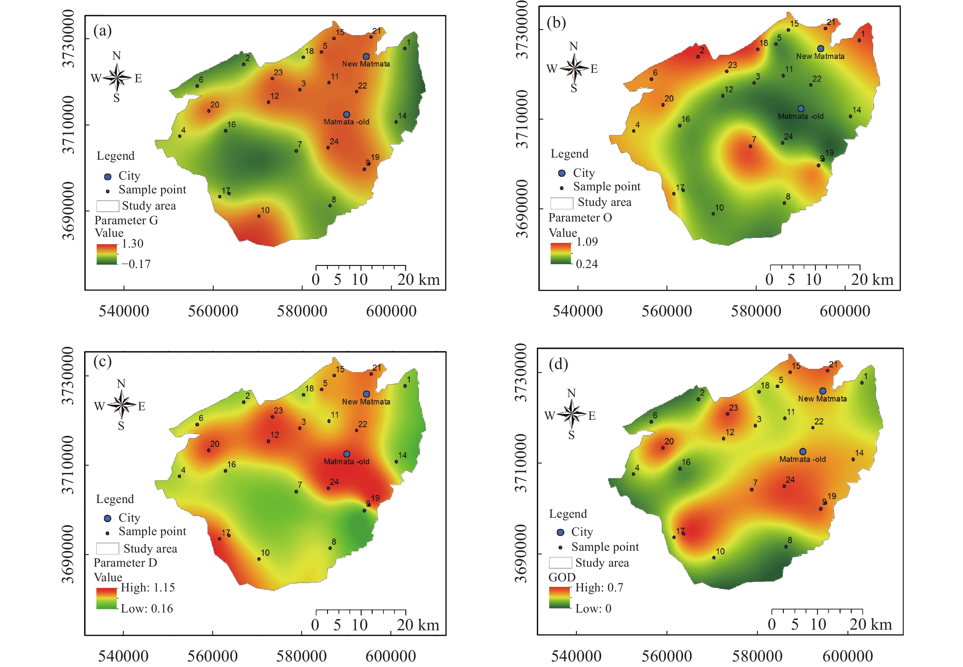
Figure 5. Parameters and results of the GOD vulnerability assessment in the study area: a) Groundwater occurrence (G), b) Overlying lithology (O), c) Depth to water table (D), (d) Final GOD vulnerability map.

Figure 6. Derived geospatial maps for the FAI analysis in the study area: (a) Digital Elevation Model (DEM) of the study area, (b) fracture network, (c) Lineament density map, and (d) resulting FAI index map.

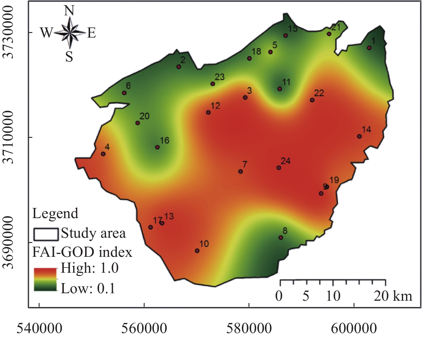
Figure 7. Spatial distribution maps of the FAI-GOD index and associated vulnerability classes

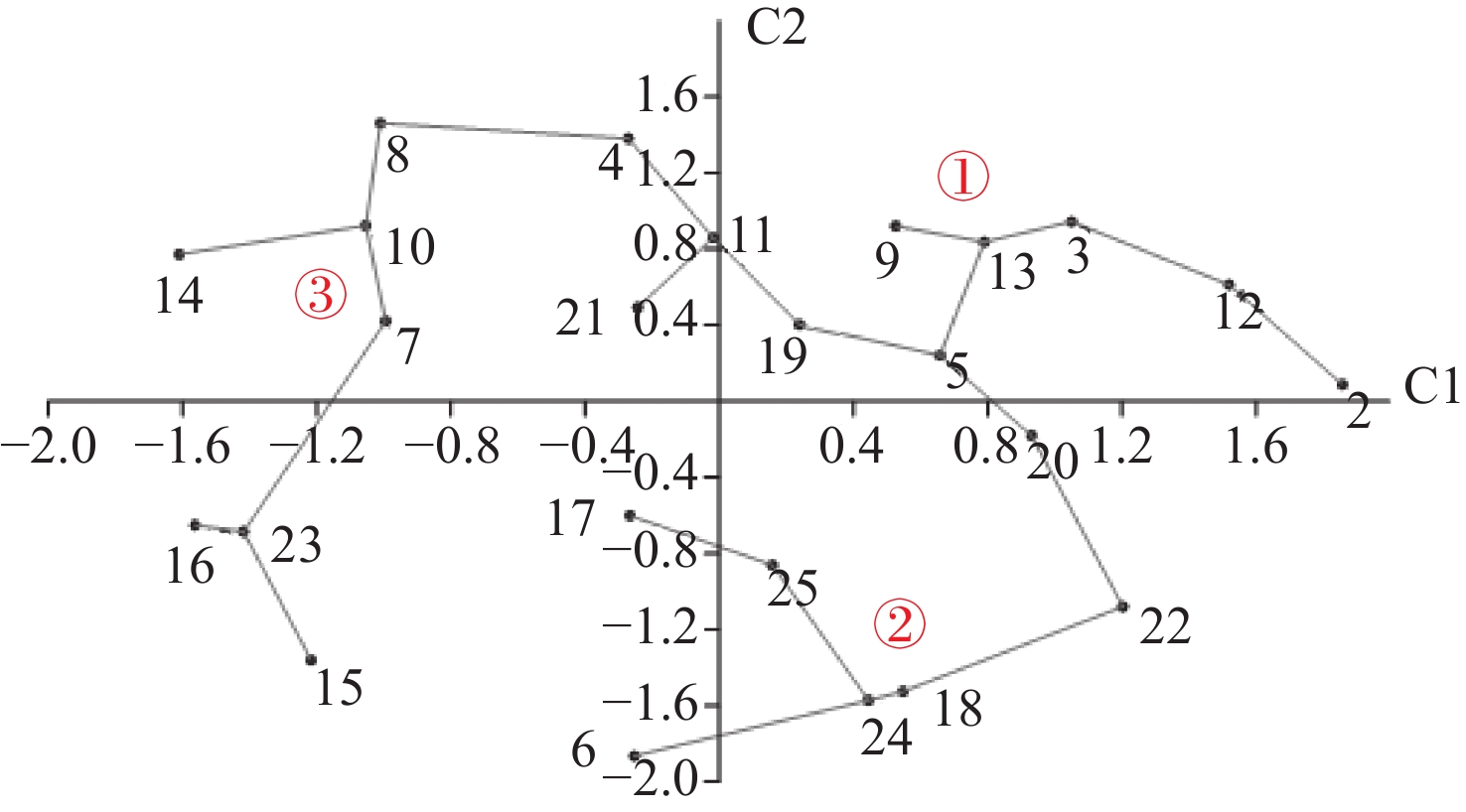
Figure 8. Projection sampled point on the C1×C2 factorial plane according to the pollution vulnerability indices
Notes: C1 and C2 represent the first and second principal components derived from the PCA analysis, which together explain the largest proportion of variance in the dataset

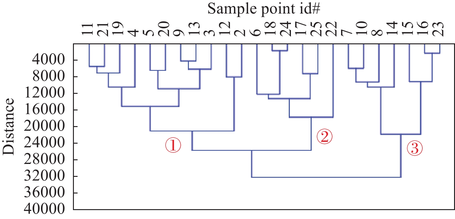
Figure 9. Hierarchical cluster analysis (HCA) of sampled points based on Euclidean distance derived from FAI-GOD vulnerability scores, revealing three distinct vulnerability groups in the study area

Figure 10. Comparison between GOD and FAI-GOD methods of aquifer vulnerability assessment in fractured aquifer. The shift toward higher vulnerability classes reflects the impact of fracture-controlled flow.

Figure 11. Polynomial regression of vulnerability assessment indicators AFI-GOD and GOD indices
Table 1. GOD vulnerability parameters, scores and index classification (Foster, 1987)
G Groundwater occurrence Score Confined and artesian 0.1 Confined 0.2 Semi-confined 0.3 Semi-unconfined covered 0.5 Unconfined 1 O Overlying lithology Score Unconsolidated sediments 0.4 Consolidated porous rocks 0.5 Aeolian sand 0.6 Alluvial sands, fluvio-glacial, sand gravels 0.7 Gravel alluvial 0.8 Unconsolidated dense rocks 0.9 Fractured or karstic Consolidate dense rocks 1 D Depth to water table (m) Score >100 0.4 50–100 0.5 20–50 0.6 10–20 0.7 5–10 0.8 2–5 0.9 0–2 1 GOD index value Vulnerability classes GOD index 0–0.1 Very low 0.1–0.3 Low 0.3–0.5 Moderate 0.5–0.7 High 0.7–1 Extremely high  下载: 导出CSV
Table 2. Lineament density values and scores
Factor Value Risk to pollution class Assigned weight to Fracture index Lineament density (km/km2) < 0.5 Low 0.1 0.5–1 Moderate 0.4 1–1.5 High 0.8 > 1.5 Very High 1.0
下载: 导出CSV
Table 3. Scores adapted to the GOD and FAI index according to aquifer type
Aquifer type GOD score (Sg) Fracture score (Sf) Porous media 1.0 0.0 Fractured rock 0.4 0.6 Karst 0.2 0.8
下载: 导出CSV
Table 4. FAI-GOD vulnerability index classification (five classes)
FAI-GOD index Vulnerability classess < 0.1 Very low 0.1–0.4 Low 0.4–0.7 Moderate 0.7–1.0 High >1 Very high
下载: 导出CSV
Table 5. Results of the GOD vulnerability assessment for the study area
Classes Percentage (%) Very low 8 Low 29 Moderate 25 High 38 Extremely high 0
下载: 导出CSV
-
Abdullah TO, Ali SS, Al-Ansari NA, et al. 2015. Groundwater vulnerability mapping using lineament density on standard DRASTIC model: Case study in halabja saidsadiq basin, Kurdistan Region, Iraq. Engineering, 7(10): 644−667. DOI: 10.4236/eng.2015.710057. Aghamelu OP, Omeka ME, Unigwe CO. 2023. Modeling the vulnerability of groundwater to pollution in a fractured shale aquifer in SE Nigeria using information entropy theory, geospatial, and statistical modeling approaches. Modeling Earth Systems and Environment, 9(2): 2385−2406. DOI: 10.1007/s40808-022-01640-y. Akintorinwa OJ, Atitebi MO, Akinlalu AA. 2020. Hydrogeophysical and aquifer vulnerability zonation of a typical basement complex terrain: A case study of Odode Idanre southwestern Nigeria. Heliyon, 6(8): e04549. DOI: 10.1016/j.heliyon.2020.e04549. Atoui M, Agoubi B. 2022. Assessment of groundwater vulnerability and pollution risk using AVI, SPI, and RGPI indexes: Applied to southern Gabes aquifer system, Tunisia. Environmental Science and Pollution Research, 29(33): 50881−50894. DOI: 10.1007/s11356-022-19309-5. Atoui M, Agoubi B. 2024. Groundwater flow modeling and recharge estimation of heterogeneous aquifer: Applied to Matmata aquifer, southeastern, Tunisia. Physics and Chemistry of the Earth, Parts A/B/C, 133: 103513. DOI: 10.1016/j.pce.2023.103513. Awawdeh M, Al-Kharabsheh N, Obeidat M, et al. 2020. Groundwater vulnerability assessment using modified SINTACS model in Wadi Shueib, Jordan. Annals of GIS, 26(4): 377−394. DOI: 10.1080/19475683.2020.1773535. Awawdeh MM, Jaradat RA. 2010. Evaluation of aquifers vulnerability to contamination in the Yarmouk River basin, Jordan, based on DRASTIC method. Arabian Journal Geosciences, 3: 273−282. DOI: 10.1007/s12517-009-0074-9. Aydi H, Balti H, Aydi A, et al. 2022. Contribution of electrical prospecting to the aquifer characterization in El Mouazir-Matmata Nouvelle in Southern Gabes, Southeastern Tunisia. Arabian Journal of Geosciences, 15(13): 1234. DOI: 10.1007/s12517-022-10463-1. Ben Hamouda MF, Mamou A, Bejaoui J, et al. 2013. Hydrochemical and isotopic study of groundwater in the north djeffara aquifer, gulf of gabès, southern Tunisia. International Journal of Geosciences, 4(8): 1−10. DOI: 10.4236/ijg.2013.48a001. Blanchard AF, Théophile L, Marc YT, et al. 2016. Cartographie de la vulnérabilité À La pollution des aquifères du socle Précambrien: Cas de la région D'oumé (centre-ouest de la Côte D'ivoire). European Scientific Journal, 12(20): 374. DOI: 10.19044/esj.2016.v12n20p374. Casadiegos-Agudelo L, Cetina-Tarazona MA, Dominguez-Rivera IC, et al. 2024. Validation of the intrinsic vulnerability to pollution of fractured siliciclastic aquifers using natural background levels. Groundwater for Sustainable Development, 25: 101143. DOI: 10.1016/j.gsd.2024.101143. Das R, Subba Rao N, Sahoo HK, et al. 2023. Nitrate contamination in groundwater and its health implications in a semi-urban region of Titrol block, Jagatsinghpur district, Odisha, India. Physics and Chemistry of the Earth, Parts A/B/C, 132: 103424. DOI: 10.1016/j.pce.2023.103424. De Souza MER, de Vargas T, Belladona R. 2022. Assessment of the vulnerability to contamination of fractured aquifers based on DRASTIC method. Águas Subterrâneas, 35(3). DOI: 10.14295/ras.v35i3.30086 Devi SP, Srinivasulu S, Raju KK. 2001. Delineation of groundwater potential zones and electrical resistivity studies for groundwater exploration. Environmental Geology, 40(10): 1252−1264. DOI: 10.1007/s002540100304. Foster SSD. 1987. Fundamental concepts in aquifer vulnerability, pollution risk and protection strategy. Vulnerability of soil and groundwater to pollutants. TNO committee on hydrological research. The Hague, Proc Info. 38: 69−86. Haidery A, Umar R. 2024. Improving groundwater vulnerability assessment in structurally controlled hard rock aquifer: Insight from lineament density and land use/land cover pattern. Environmental Monitoring and Assessment, 196(8): 723. DOI: 10.1007/s10661-024-12880-z. Hamza SM, Ahsan A, Imteaz MA, et al. 2017. GIS-based FRASTIC model for pollution vulnerability assessment of fractured-rock aquifer systems. Environmental Earth Sciences, 76(5): 197. DOI: 10.1007/s12665-017-6520-1. Hao J, Zhang YX, Jia YW, et al. 2017. Assessing groundwater vulnerability and its inconsistency with groundwater quality, based on a modified DRASTIC model: A case study in Chaoyang District of Beijing City. Arabian Journal of Geosciences, 10(6): 144. DOI: 10.1007/s12517-017-2885-4. Hoque MA, Khan AA, Shamsudduha M, et al. 2009. Near surface lithology and spatial variation of arsenic in the shallow groundwater: Southeastern Bangladesh. Environmental Geology, 56(8): 1687−1695. DOI: 10.1007/s00254-008-1267-3. Javadi S, Hashemy SM, Mohammadi K, et al. 2017. Classification of aquifer vulnerability using K-means cluster analysis. Journal of Hydrology, 549: 27−37. DOI: 10.1016/j.jhydrol.2017.03.060. Jemai S, Kallel A, Agoubi B, et al. 2022. Spatial and temporal rainfall variability and its controlling factors under an arid climate condition: Case of Gabes Catchment, Southern Tunisia. Environment, Development and Sustainability, 24(4): 5496−5513. DOI: 10.1007/s10668-021-01668-7. Jenifer MA, Jha MK. 2018. Comparative evaluation of GIS-based models for mapping aquifer vulnerability in hard-rock terrains. Environmental Earth Sciences, 77(19): 672. DOI: 10.1007/s12665-018-7821-8. Krasny J, 1993. Classification of transmissivity magnitude and variation. Groundwater, 31 (2): 230−236. Khatri N, Tyagi S. 2015. Influences of natural and anthropogenic factors on surface and groundwater quality in rural and urban areas. Frontiers in Life Science, 8(1): 23−39. DOI: 10.1080/21553769.2014.933716. Lubianetzky TA, Dickson SE, Guo Y. 2015. Proposed method: Incorporation of fractured rock in aquifer vulnerability assessments. Environmental Earth Sciences, 74(6): 4813−4825. DOI: 10.1007/s12665-015-4471-y. MacDonald AM, Bell RA, Kebede S, et al. 2019. Groundwater and resilience to drought in the Ethiopian Highlands. Environmental Research Letters, 14(9): 095003. DOI: 10.1088/1748-9326/ab282f. Mendoza JA, Barmen G. 2006. Assessment of groundwater vulnerability in the río artiguas basin, Nicaragua. Environmental Geology, 50(4): 569−580. DOI: 10.1007/s00254-006-0233-1. Piscopo G. 2001. Groundwater Vulnerability Map, Explanatory Notes, Castlereagh Catchment, NSW. Department of Land and Water Conservation, Parramatta. ISBN 0 7347 5193 1 CNR 2001.017, 18p. Rao NS, Dinakar A, Sravanthi M, et al. 2021. Geochemical characteristics and quality of groundwater evaluation for drinking, irrigation, and industrial purposes from a part of hard rock aquifer of South India. Environmental Science and Pollution Research, 28(24): 31941−31961. DOI: 10.1007/s11356-021-12404-z. Rahmani B, Javadi S, Shahdany SMH. 2021. Evaluation of aquifer vulnerability using PCA technique and various clustering methods. Geocarto International, 36(18): 2117−2140. DOI: 10.1080/10106049.2019.1690057. Sarikhani R, Kamali Z, Dehnavi AG, et al. 2014. Correlation of lineaments and groundwater quality in dasht-e-arjan fars, SW of Iran. Environmental Earth Sciences, 72(7): 2369−2387. DOI: 10.1007/s12665-014-3146-4. Sekar S, Kamaraj J, Poovalingam S, et al. 2023. Appraisal of groundwater vulnerability pollution mapping using GIS based GOD index in tiruchendur, thoothukudi district, India. Water, 15(3): 520. DOI: 10.3390/w15030520. Shrestha S, Kafle R, Pandey VP. 2017. Evaluation of index-overlay methods for groundwater vulnerability and risk assessment in Kathmandu Valley, Nepal. Science of The Total Environment, 575: 779−790. DOI: 10.1016/j.scitotenv.2016.09.141. Tam VT, De Smedt F, Batelaan O, et al. 2004. Study on the relationship between lineaments and borehole specific capacity in a fractured and karstified limestone area in Vietnam. Hydrogeology Journal, 12: 662−673. DOI: 10.1007/s10040-004-0329-1. Torkashvand M, Neshat A, Javadi S, et al. 2021. New hybrid evolutionary algorithm for optimizing index-based groundwater vulnerability assessment method. Journal of Hydrology, 598: 126446. DOI: 10.1016/j.jhydrol.2021.126446. Tsegay T, Birhanu B, Azagegn T, et al. 2024. Assessing groundwater vulnerability to pollution in a rapidly urbanizing river basin using a modified DRASTIC land use–lineament density method. Geological Journal, 59(12): 3278−3295. DOI: 10.1002/gj.5059. -

 点击查看大图
计量
- 文章访问数: 6629
- HTML全文浏览量: 2733
- PDF下载量: 174
- 被引次数: 0


