 E-mail alert
 Rss
Rss

Estimating evapotranspiration at high spatio-temporal resolution based on the Bayesian model averaging method in Baoding Plain, China
-
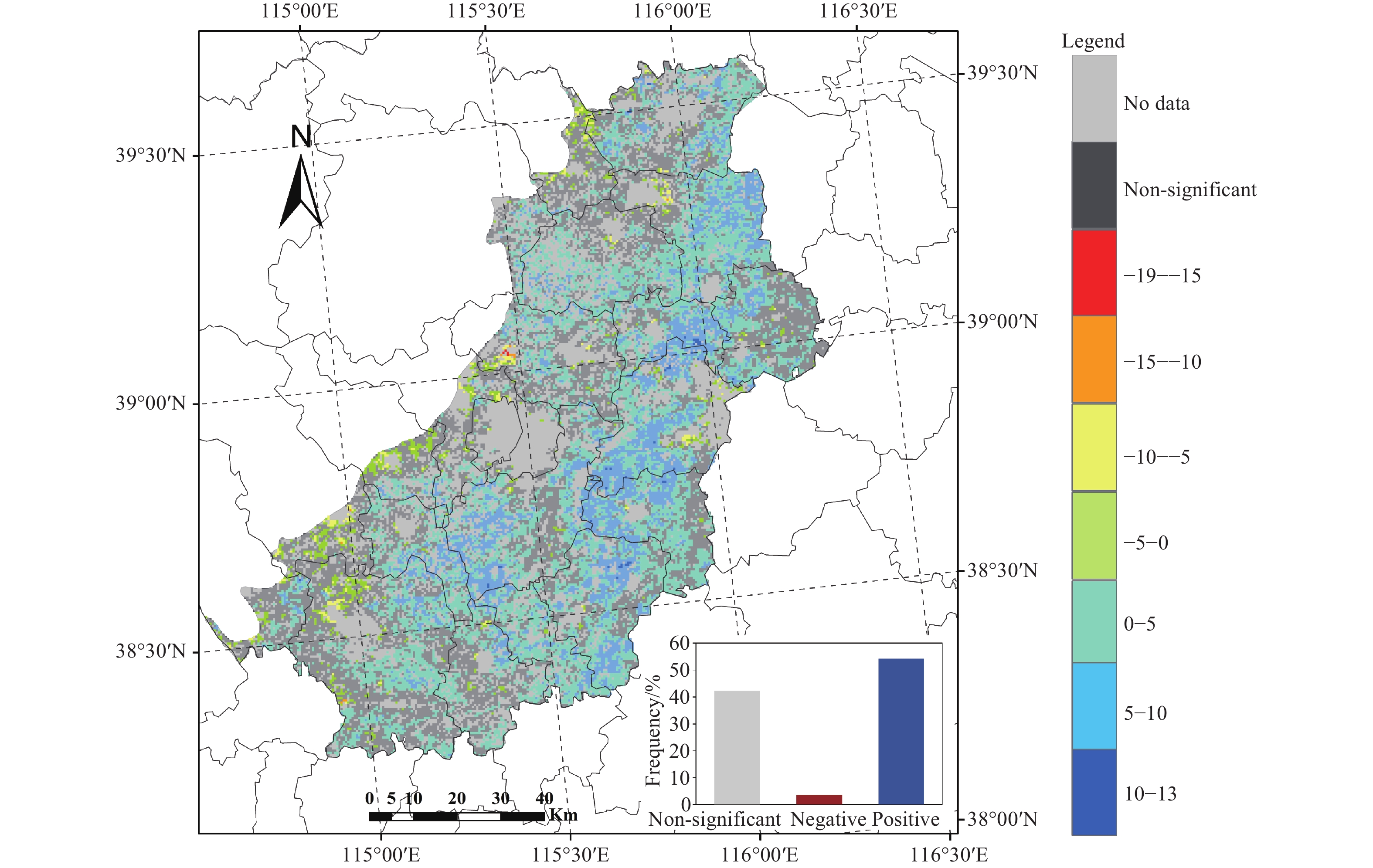
Abstract: Evapotranspiration (ET) is a core parameter of the hydrology and carbon cycles, and its accurate estimation is crucial for water resource management. Satellite-based ET products provide an effective means for large-scale monitoring. However, due to limitations in the spatial and temporal resolution, the use of these products at regional and field scales is limited. In this study, daily ET in the Baoding Plain—a key groundwater resource recharge area—was estimated at a 500 m spatial resolution using the Bayesian Model Averaging (BMA) method. The model was driven by a synthesis of remote sensing datasets, reanalysis products, and interpolated data from meteorological stations. Validation results from in-situ observations indicated that the BMA ET had better performance (R=0.83, RMSE=1.25 mm/d) than each model in the BMA scheme. The spatiotemporal analysis revealed that the average annual BMA ET in the Baoding Plain was 683 mm/year from 2000 to 2019. Seasonal and monthly variations in the BMA ET captured the irrigation and water consumption patterns of the local crop rotation systems. A significant increasing trend of BMA ET (2.40 mm/year2) was observed in the Baoding Plain over the study period. At the regional scale, ET over more than 50% of the plain exhibited a significant positive trend. Further analysis identified water availability, solar radiation, and temperature as the primary drivers of ET variation. The BMA ET product generated in this study is characterized by high spatiotemporal resolution and accuracy. This reliable, high-resolution dataset offers valuable support for precision agricultural water management and hydrological studies, including groundwater investigations, in this predominantly agricultural region.
-
Key words:
- Evapotranspiration /
- Satellite-based model /
- Random Forest model /
- Climate change /
- Water resources
-

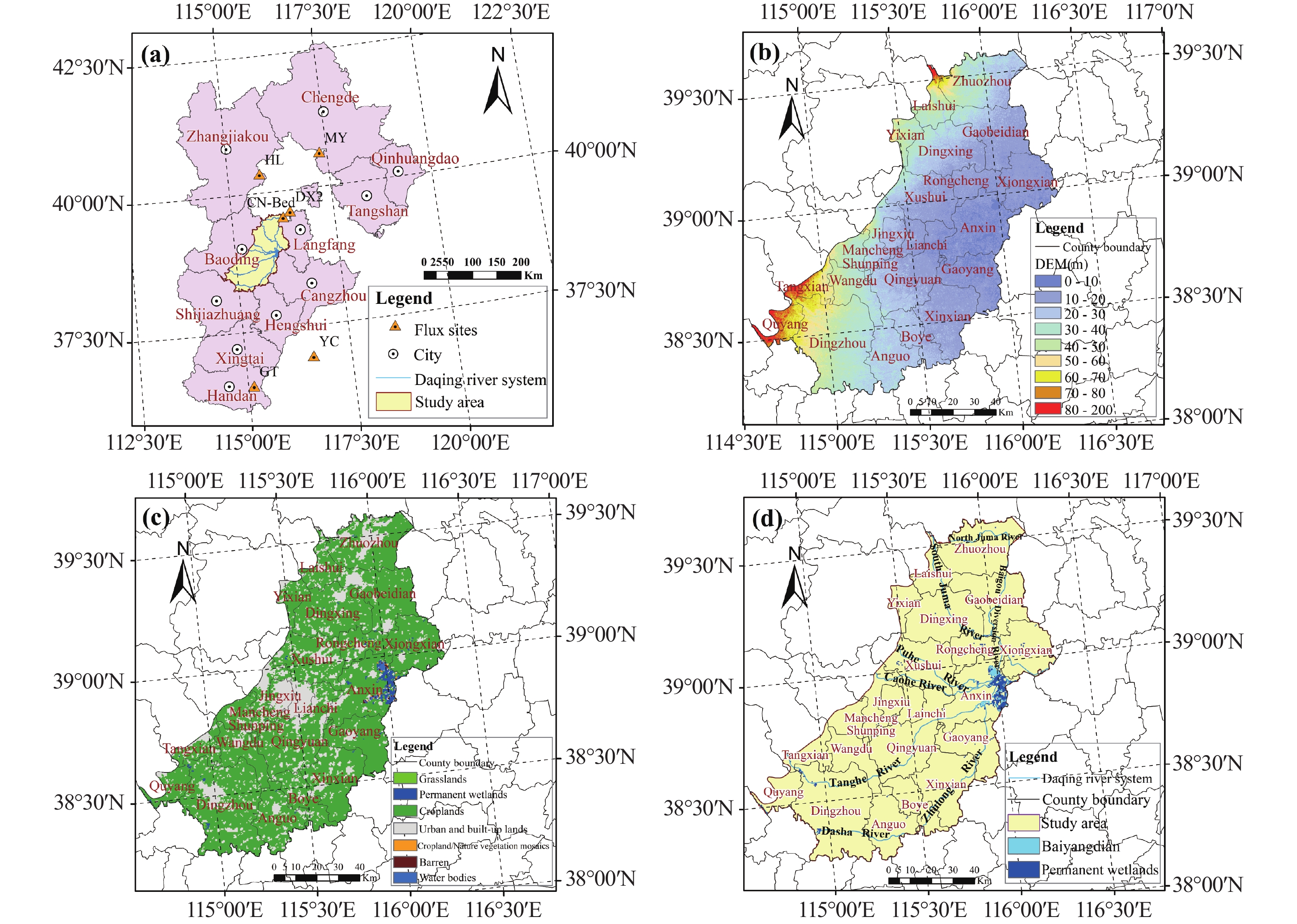
Figure 1. Overview of the Baoding Plain
Notes: (a) Location of the Baoding Plain (i.e. the study area) within Hebei Province and the distribution of the flux sites. (b) The digital elevation model (DEM) of the Baoding Plain; (c) The land cover types in the Baoding Plain; (d) Overview of the water systems and the location of Baiyangdian Lake within the Baoding Plain

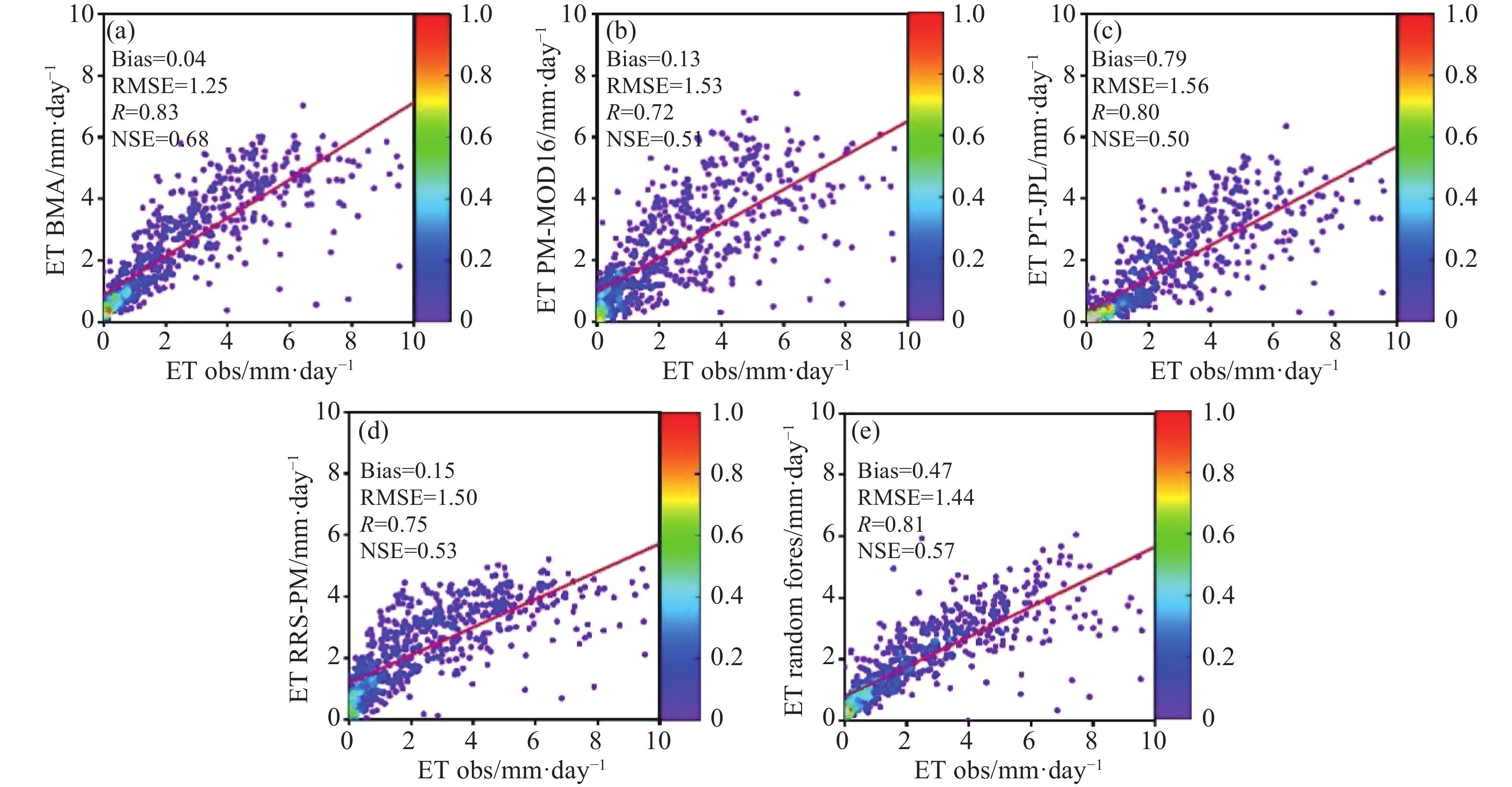
Figure 2. Observed evapotranspiration (ET) at eddy-covariance sites versus predicted ET from BMA and the four models. The red solid lines are the regression lines

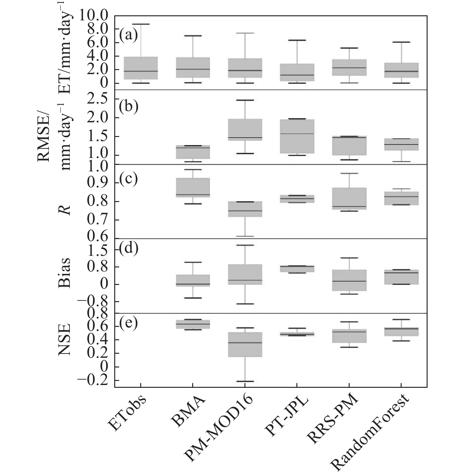
Figure 3. Comparison of ET observations and simulations of the BMA and four single models at 6 EC sites: (a) mean values; (b) RMSE; (c) R; (d) bias and (e) NSE

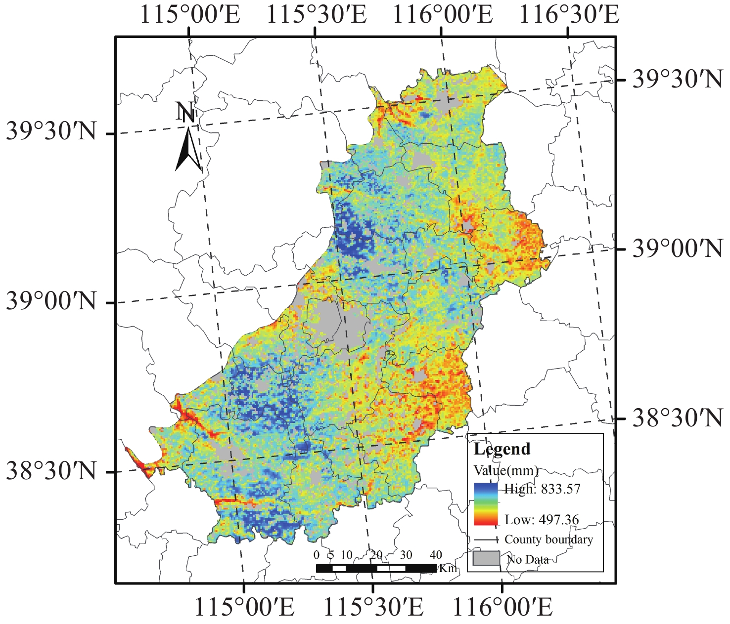
Figure 4. The spatial distribution of ET estimates from the BMA method in the Baoding Plain from 2000 to 2019

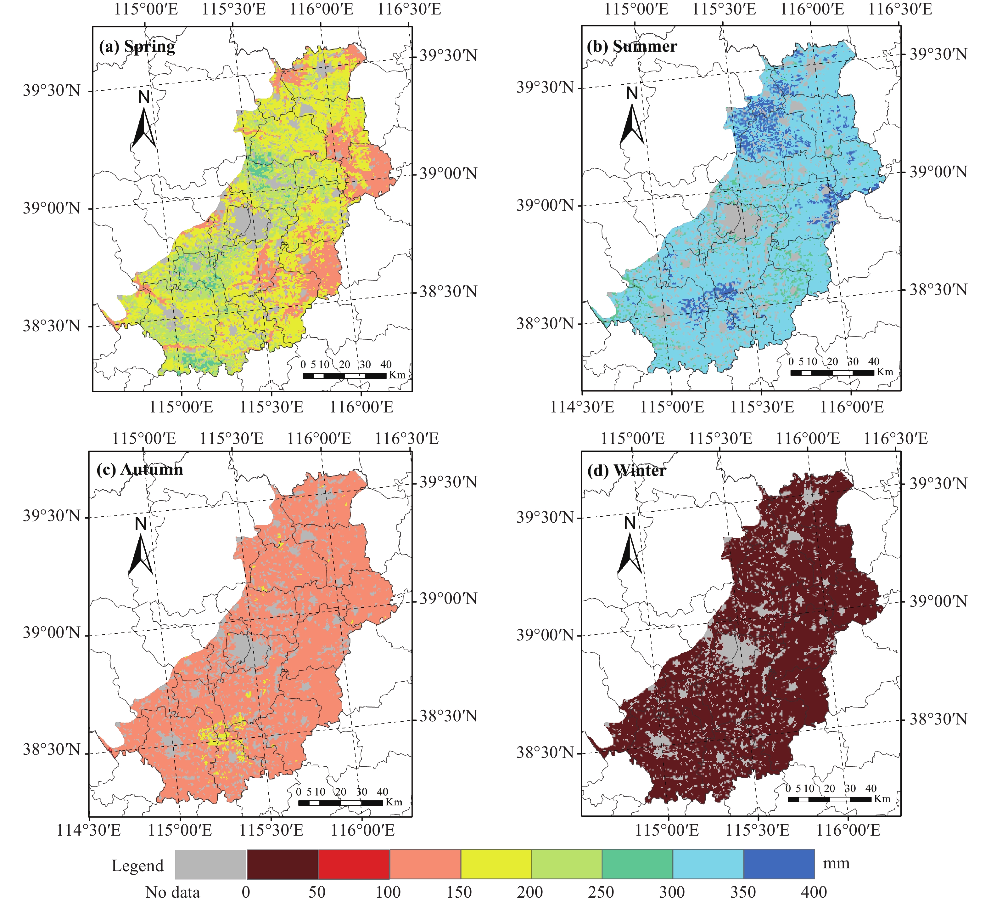
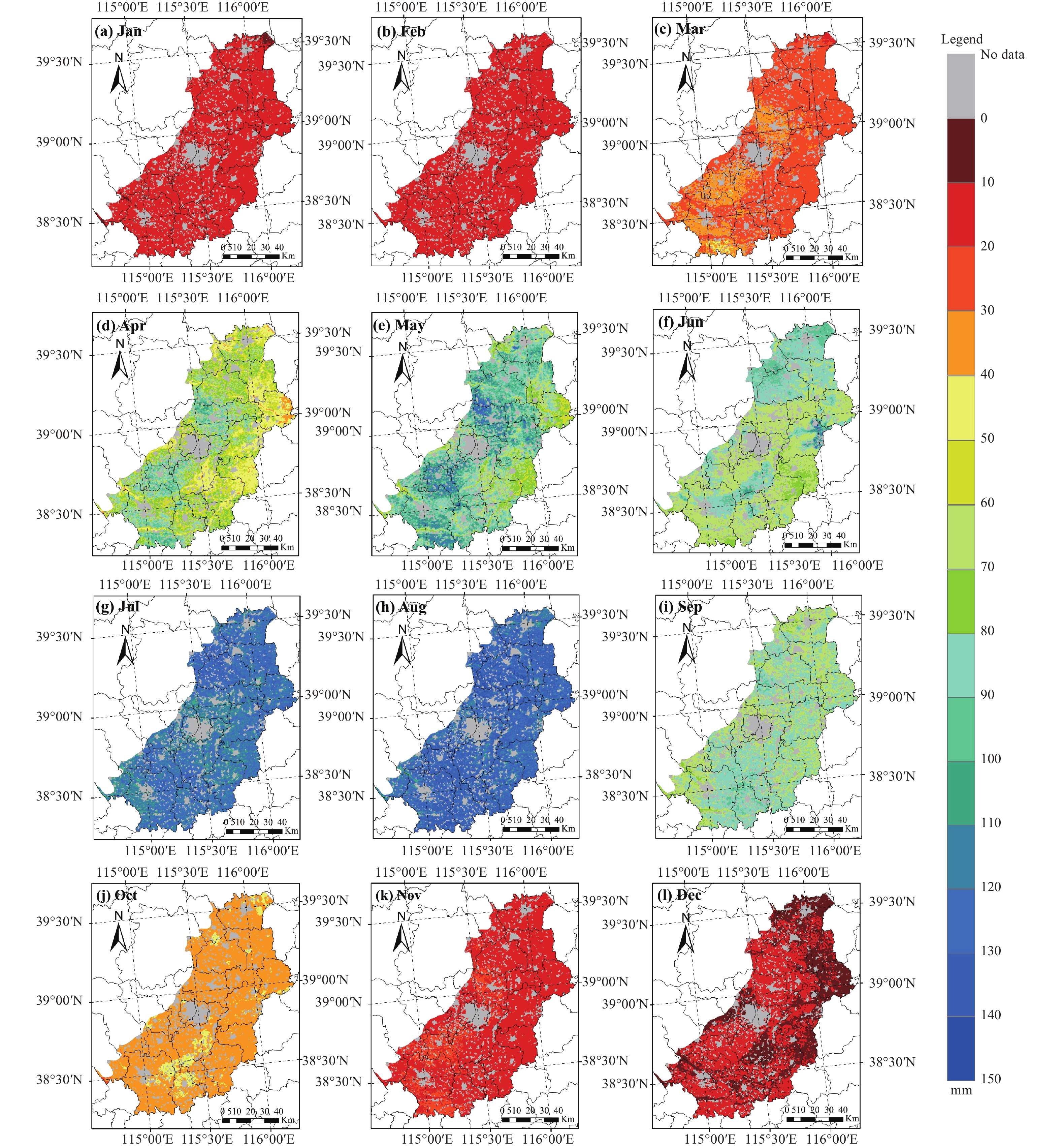
Figure 5. Spatial distributions of seasonal ET values in the Baoding Plain from 2000 to 2019

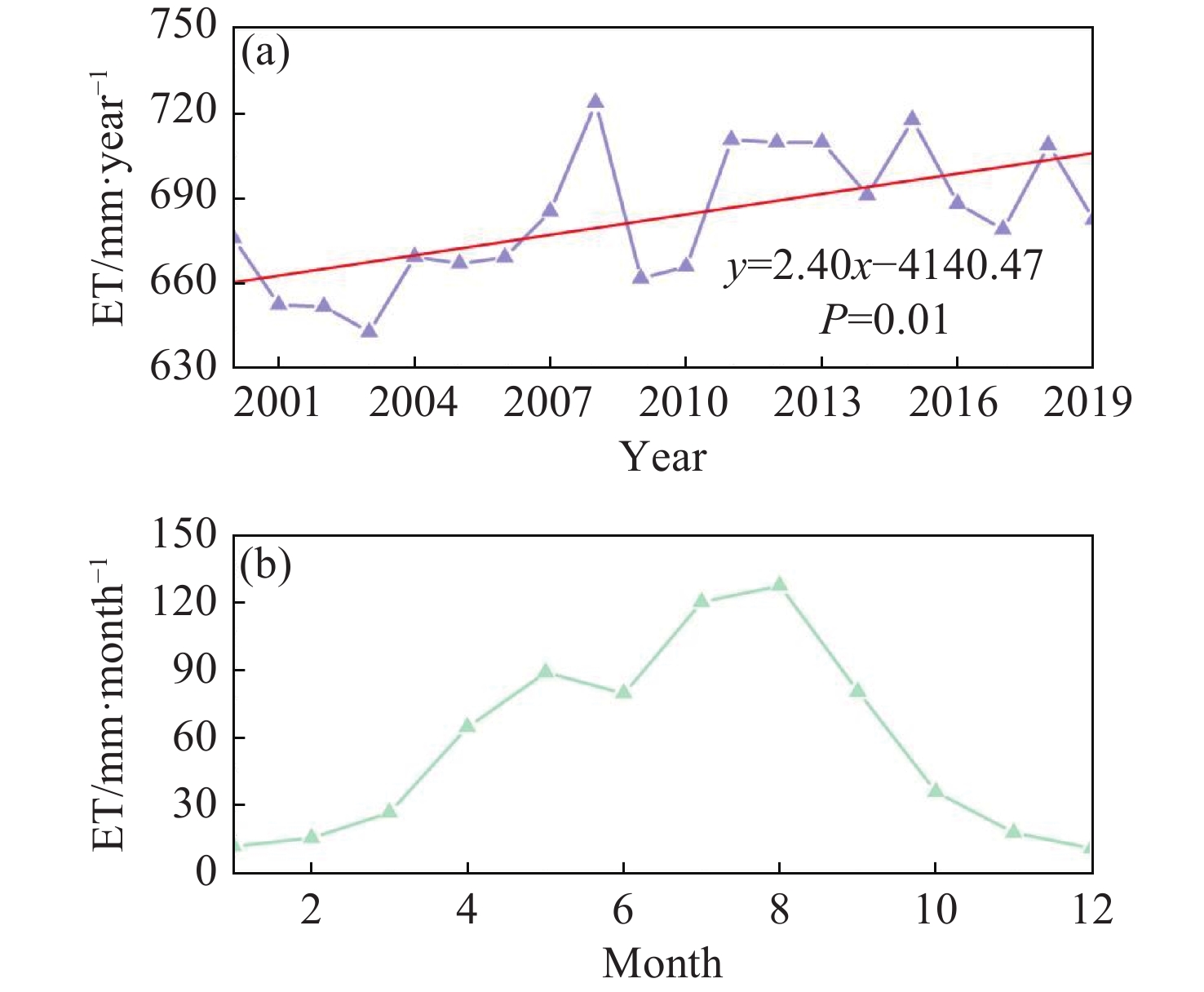
Figure 7. Temporal variability of the mean BMA ET in the Baoding Plain: (a) Interannual variability and (b) the seasonal variability

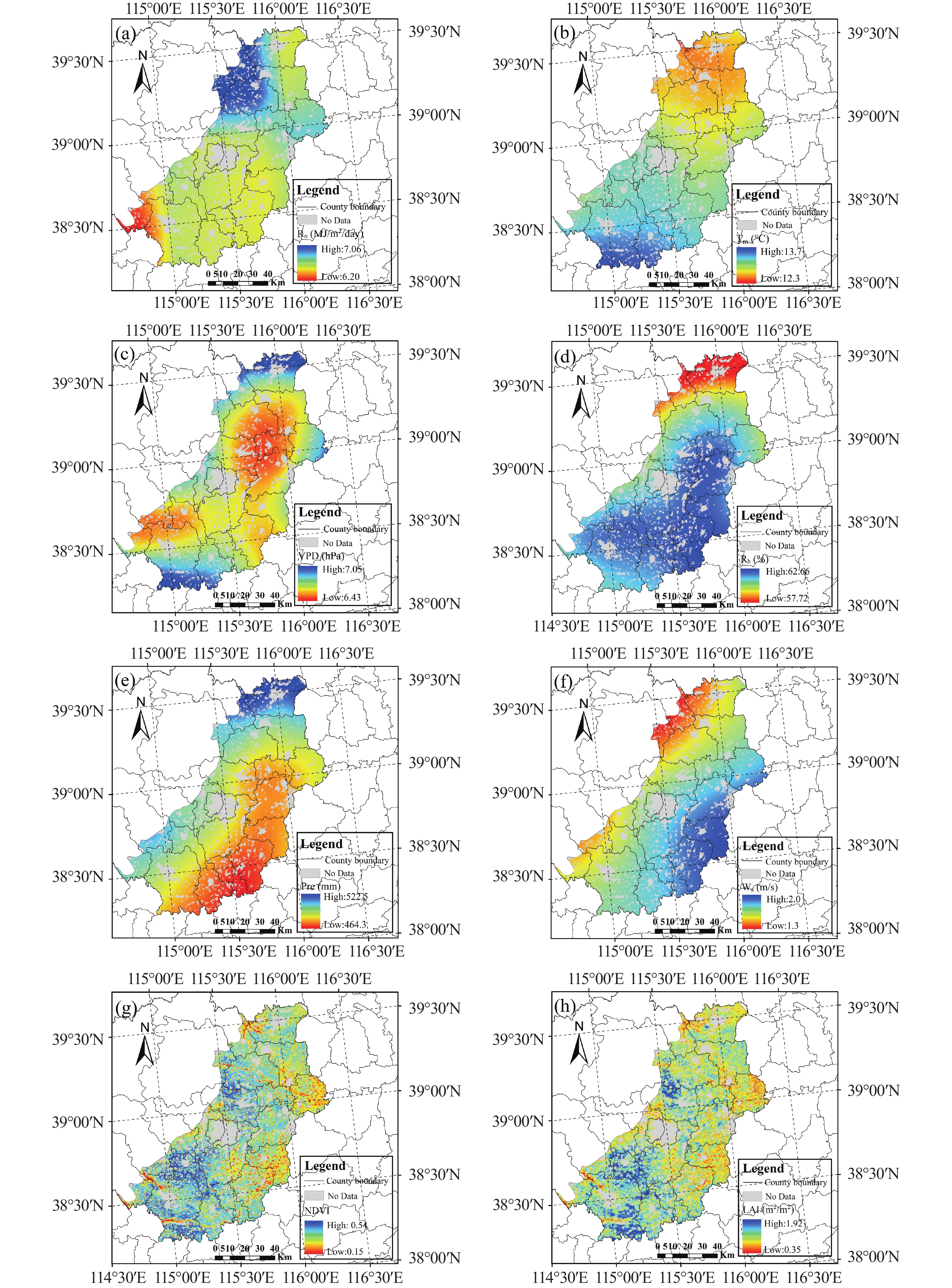
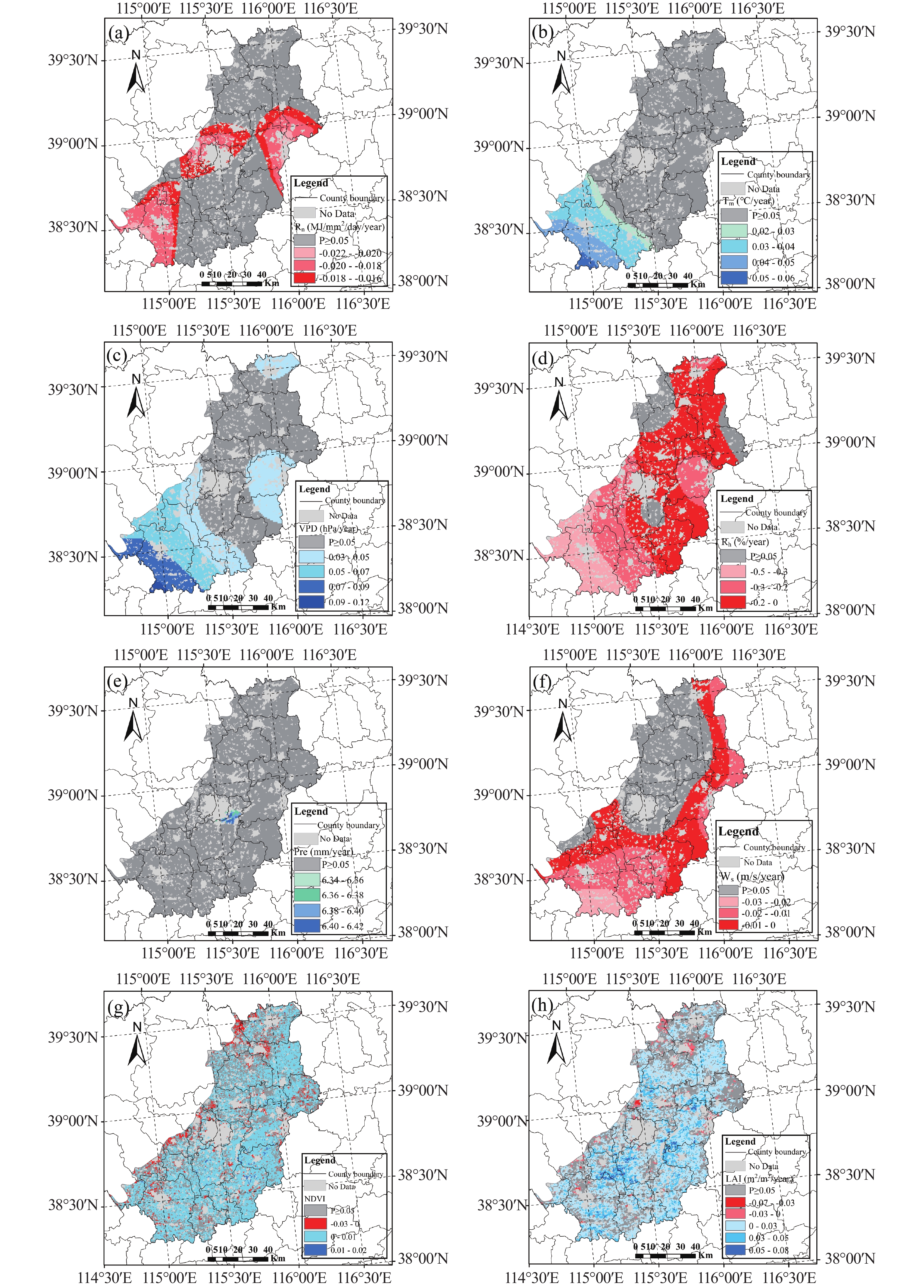
Figure 9. Spatial patterns of environmental variables including (a) Rn, (b) Tm, (c) VPD, (d) Rh, (e) Pre, (f) Ws, (g) NDVI and (h) LAI

Figure 10. Spatial patterns of trends in (a) Rn, (b) Tm, (c) VPD, (d) Rh, (e) Pre, (f) Ws, (g) NDVI and (h) LAI

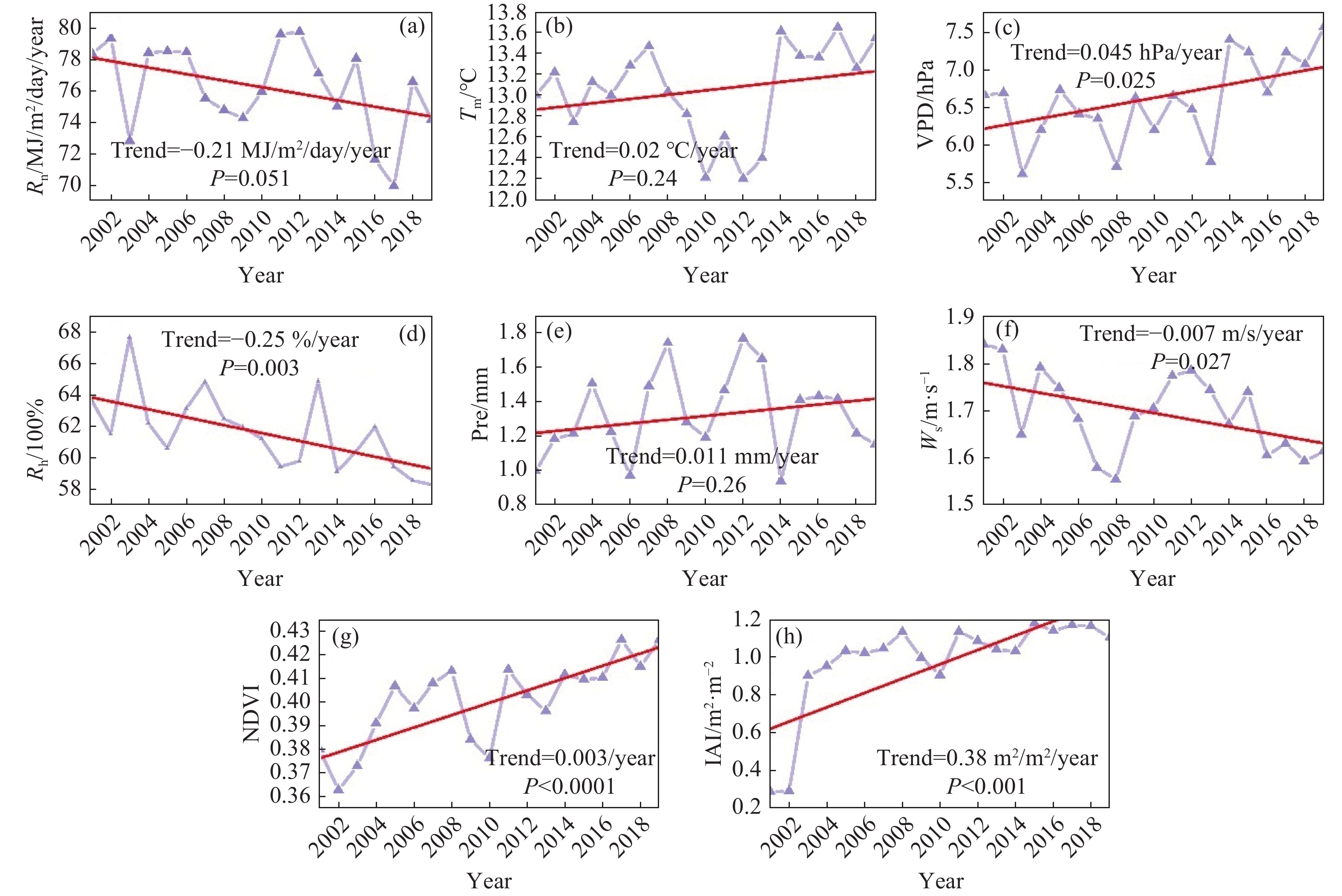
Figure 11. Interannual variations of (a) Rn, (b) Tm, (c) VPD, (d) Rh, (e) Pre, (f) Ws, (g) NDVI, and (h) LAI

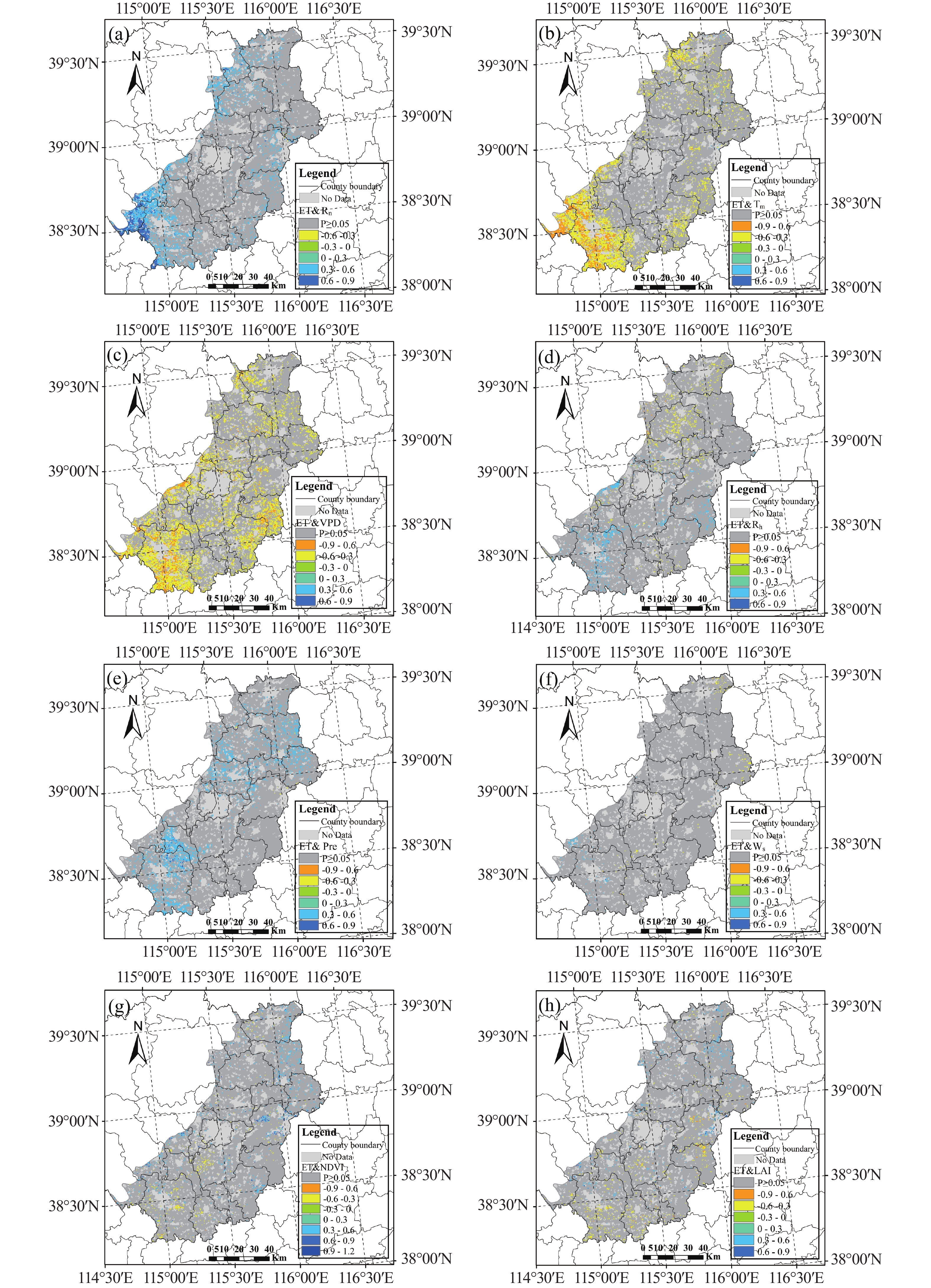
Figure 12. Pearson's correlation coefficients between environmental variables and ET. The grids in dark gray indicate P>0.05 (non-significant correlations)

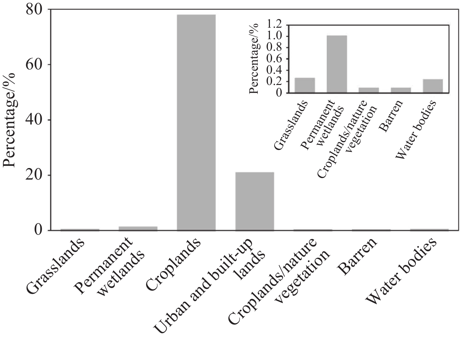
Figure 13. The area percentage of land use and land cover types of the total area
Notes: The inset shows the area percentages of the land use types with small proportions

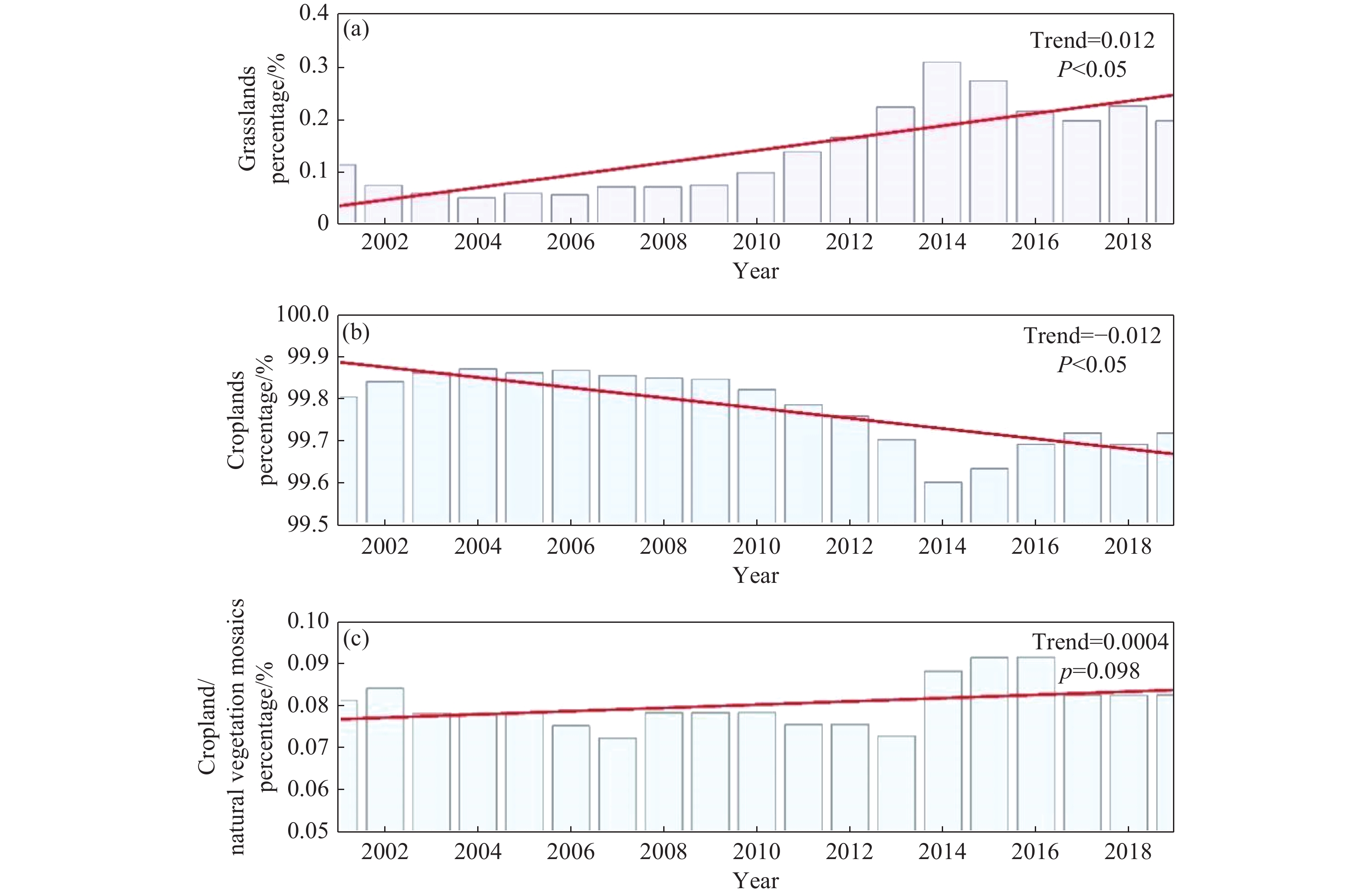
Figure 14. Changes in the percentage share of each ecosystem type relative to the total terrestrial ecosystem area during 2000—2019
Table 1. Details of flux sites
Site name Sources Location information Time period Vegetational type CN-Bed LaThuile Flux (39.53°N,116.25°E) 2005—2006 Forest DX2 The National Tibetan Plateau Data Center (39.62°N,116.43°E) 2008—2010 Cropland GT The National Tibetan Plateau Data Center (36.52°N,115.13°E) 2008—2010 Cropland HL The National Tibetan Plateau Data Center (40.35°N,115.79°E) 2013—2017 Cropland MY The National Tibetan Plateau Data Center (40.63°N,117.32°E) 2008—2010 Cropland YC China Flux (36.95°N,116.60°E) 2003—2010 Cropland  下载: 导出CSV
Table 2. Details of regional datasets
Type Dataset Time span Temporal resolution Spatial resolution Remote sensing datasets MCD12Q1 2000—2019 yearly 500 m MOD13Q1 2000—2019 16-day 250 m MOD15A2 2000—2019 8-day 500 m SRTMv4.1 2008 yearly 90 m Reanalysis dataset GLDAS 2.1 2000—2019 3-hour 0.25°
下载: 导出CSV
Table 3. Validation of regional interpolation datasets using flux site data.
Rn (W/m2) Tm (°C) Rh (%) Ps (hPa) R 0.87 0.99 0.93 0.82 Bias 15.17 −0.06 −0.23 −3.76 RMSE 32.90 1.60 7.62 14.86 NSE 0.60 0.98 0.84 0.65
下载: 导出CSV
Table 4. Uncertainty analysis of BMA ET at each site.
Site Mean Standard Deviation 90% conf.int Containing Ratio (CR) Average Relative Deviation Amplitude (RD) CN-Bed 3.50 0.97 (1.98, 5.18) 88.73% 3.45 DX2 1.41 0.51 (0.61, 2.28) 100% 0.16 GT 0.67 0.09 (0.53, 0.83) 95.45% 0.35 HL 0.82 0.34 (0.34, 1.45) 93.42% 0.57 YC 1.45 0.22 (1.10, 1.86) 95.23% 0.51 * Due to the insufficient data volume after data quality control, the MY station was excluded from the Monte Carlo uncertainty quantification.
下载: 导出CSV
-
Bai H, Yang HF, Meng RF, et al. 2023. Chemical characteristics and evolution of groundwater in Baoding Plain. Geological Review, 69(06): 2216−2228. (in Chinese) DOI: 10.16509/j.georeview.2023.06.065. Breiman L. 2001. Random forests. Machine learning, 45: 5−32. DOI: 10.1023/A:101093340432. Cao WG, Yang HF, Gao YY, et al. 2020. Prediction of groundwater quality evolution in the Baoding Plain of the SNWDP benefited regions. Journal of Hydraulic Engineering, 51(08): 924−935. (in Chinese) DOI: 10.13243/j.cnki.slxb.20200035. Chen Y, Xia JZ, Liang SL, et al. 2014. Comparison of satellite-based evapotranspiration models over terrestrial ecosystems in China. Remote Sensing of Environment, 140: 279−293. DOI: 10.1016/j.rse.2013.08.045. Chen Y, Yuan WP, Xia JZ, et al. 2015. Using bayesian model averaging to estimate terrestrial evapotranspiration in China. Journal of Hydrology, 528: 537−549. DOI: 10.1016/j.jhydrol.2015.06.059. Cherubini F, Huang B, Hu XP, et al. 2018. Quantifying the climate response to extreme land cover changes in europe with a regional model. Environmental Research Letters, 13(7): 074002. DOI: 10.1088/1748-9326/aac794. Chilukoti N, Xue YK. 2020. An assessment of potential climate impact during 1948–2010 using historical land use land cover change maps. International Journal of Climatology, 41(1): 295−315. DOI: 10.1002/joc.6621. Cleugh HA, Leuning R, Mu Q, et al. 2007. Regional evaporation estimates from flux tower and modis satellite data. Remote Sensing of Environment, 106(3): 285−304. DOI: 10.1016/j.rse.2006.07.007. Elzain HE, Abdalla OA, Abdallah M, et al. 2024. Innovative approach for predicting daily reference evapotranspiration using improved shallow and deep learning models in a coastal region: A comparative study. Journal of Environmental Management, 354: 120246. DOI: 10.1016/j.jenvman.2024.120246. Fan Y, Yang Z, Lo MH, et al. 2025. Deciphering the capricious precipitation response: Irrigation impact in the north China plain. Npj Climate and Atmospheric Science, 8(1): 211. DOI: 10.1038/s41612-025-01063-3. Feng Z, Sun L. 2024. Water conservation implications based on tempo-spatial characteristics of water footprint in the water-receiving areas of the South-to-North Water Diversion Project, China. Sustainability, 16(3): 1270. DOI: 10.3390/su16031270. Fisher JB, Tu KP, Baldocchi DD. 2008. Global estimates of the land–atmosphere water flux based on monthly avhrr and islscp-ii data, validated at 16 fluxnet sites. Remote Sensing of Environment, 112(3): 901−919. DOI: 10.1016/j.rse.2007.06.025. Huang HP, Liang ZM, Li BQ, et al. 2019. Combination of multiple data-driven models for long-term monthly runoff predictions based on bayesian model averaging. Water Resources Management, 33(9): 3321−3338. DOI: 10.1007/s11269-019-02305-9. Koch J, Zhang WM, Martinsen G, et al. 2020. Estimating net irrigation across the north China plain through dual modeling of evapotranspiration. Water Resources Research, 56(12): e2020WR027413. DOI: 10.1029/2020WR027413. Long D, Yang W, Scanlon BR, et al. 2020. South-to-north water diversion stabilizing beijing's groundwater levels. Nature Communications, 11(1): 3665. DOI: 10.1038/s41467-020-17428-6. Mohtaram A, Shafizadeh-Moghadam H, Ketabchi H. 2025. A flexible multi-scale approach for downscaling grace-derived groundwater storage anomaly using lightgbm and random forest in the tashk-bakhtegan basin, Iran. Journal of Hydrology: Regional Studies, 57: 102086. DOI: 10.1016/J.EJRH.2024.102086. Mu QZ, Zhao MS, Running SW. 2011. Improvements to a modis global terrestrial evapotranspiration algorithm. Remote Sensing of Environment, 115(8): 1781−1800. DOI: 10.1016/j.rse.2011.02.019. Peng H, Jia Y, Zhan C, et al. 2020. Topographic controls on ecosystem evapotranspiration and net primary productivity under climate warming in the Taihang mountains, China. Journal of Hydrology, 581: 124394. DOI: 10.1016/j.jhydrol.2019.124394. Raftery AE, Gneiting T, Balabdaoui F, et al. 2005. Using bayesian model averaging to calibrate forecast ensembles. American Meteorological Society, 133(5): 1155−1174. DOI: 10.1175/MWR2906.1. Ren W, Banger K, Tao B, et al. 2020. Global pattern and change of cropland soil organic carbon during 1901-2010: Roles of climate, atmospheric chemistry, land use and management. Geography and Sustainability, 1(1): 59−69. DOI: 10.1016/j.geosus.2020.03.001. Shen H, Li J, Wu G, et al. 2025. Can cmip6 models accurately reproduce terrestrial evapotranspiration across China? International Journal of Climatology, 45(6): e8794. DOI: 10.1002/JOC.8794. Siebert S, Burke J, Faures JM, et al. 2010. Groundwater use for irrigation – a global inventory. Hydrology and Earth System Sciences, 14(10): 1863−1880. DOI: 10.5194/hess-14-1863-2010. Su T, Sun S, Wang S, et al. 2022. Spatiotemporal variation of actual evapotranspiration and its relationship with precipitation in northern china under global warming. Remote Sensing, 14(18): 4554. DOI: 10.3390/rs14184554. Sun SB, Chen BZ, Yan JW, et al. 2024. Potential impacts of land use and land cover change (LUCC) and climate change on evapotranspiration and gross primary productivity in the haihe river basin, China. Journal of Cleaner Production, 476: 143729. DOI: 10.1016/J.JCLEPRO.2024.143729. Yan LL, Cheng YB, Chen XH, et al. 2018. Verification of Type A Evaluation Methods of Uncertainty Based on Monte Carlo Method. Journal of Henan University of Science and Technology (Natural Science), 39(5): 17−20. (in Chinese) DOI: 10.15926/j.cnki.issn1672-6871.2018.05.004. Yang C, Lei HM. 2022. Climate and management impacts on crop growth and evapotranspiration in the north china plain based on long-term eddy covariance observation. Agricultural and Forest Meteorology, 325: 109147. DOI: 10.1016/J.AGRFORMET.2022.109147. Yang Y, Sun HW, Xue J, et al. 2021. Estimating evapotranspiration by coupling bayesian model averaging methods with machine learning algorithms. Environmental Monitoring and Assessment, 193(3): 156−156. DOI: 10.1007/S10661-021-08934-1. Yuan WP, Liu SG, Yu GR, et al. 2010. Global estimates of evapotranspiration and gross primary production based on modis and global meteorology data. Remote Sensing of Environment, 114(7): 1416−1431. DOI: 10.1016/j.rse.2010.01.022. Zhang C, Liu JG, Shang JL, et al. 2021. Improving winter wheat biomass and evapotranspiration simulation by assimilating leaf area index from spectral information into a crop growth model. Agricultural Water Management, 255: 107057. DOI: 10.1016/J.AGWAT.2021.107057. Zheng M, Zha Y, Bian J, et al. 2025. Analysis of temporal and spatial changes in regional evapotranspiration in china and the factors affecting them, 2003–2020. Theoretical and Applied Climatology, 156(11): 601. DOI: 10.1007/s00704-025-05825-0. -

 点击查看大图
计量
- 文章访问数: 3190
- HTML全文浏览量: 1431
- PDF下载量: 13
- 被引次数: 0


