 E-mail alert
 Rss
Rss



Evaluation of groundwater artificial recharge potential in the western Huaibei Plain, China
-
Abstract: To mitigate groundwater overexploitation and support the scientifically informed siting of artificial recharge infrastructure in the western Huaibei Plain, this study develops a multi-criteria evaluation framework for recharge suitability, focusing on the western portion of the Huaibei Plain. The framework integrates five hydrogeologically significant indicators: Groundwater table depth, saturated thickness of the primary aquifer, hydraulic conductivity, precipitation infiltration coefficient, and proximity to perennial rivers. Indicator weights were determined through a hybrid weighting strategy—combining the analytic hierarchy process, criteria importance through intercriteria correlation, and coefficient of variation methods—to balance subjective judgment with objective data-driven variance. These weights were spatially implemented using ArcGIS-based multi-criteria decision analysis to generate a continuous recharge suitability index map. The integrated weights derived from the hybrid approach are 0.222, 0.254, 0.173, 0.185, and 0.166 for the respective indicators. Recharge suitability was classified into four ordinal categories—high, moderate, low, and unsuitable—using the natural breaks optimization method. High and moderate potential zones collectively occupy 32.93% of the study area and are predominantly located in Funan, Qiaocheng, Guoyang, and Mengcheng counties—regions identified as priority candidates for artificial recharge project implementation. A sensitivity analysis confirms the stability and reliability of the zoning outcomes under parameter perturbation. By quantitatively identifying dominant controlling factors, delineating spatially explicit potential classes, and pinpointing priority implementation zones, this study establishes a transferable methodological framework. It directly supports sustainable groundwater management in the western Huaibei Plain and offers actionable guidance for optimizing recharge infrastructure placement. Moreover, the approach demonstrates broad applicability for recharge potential assessment and integrated water resources planning in hydrologically similar alluvial plain settings.
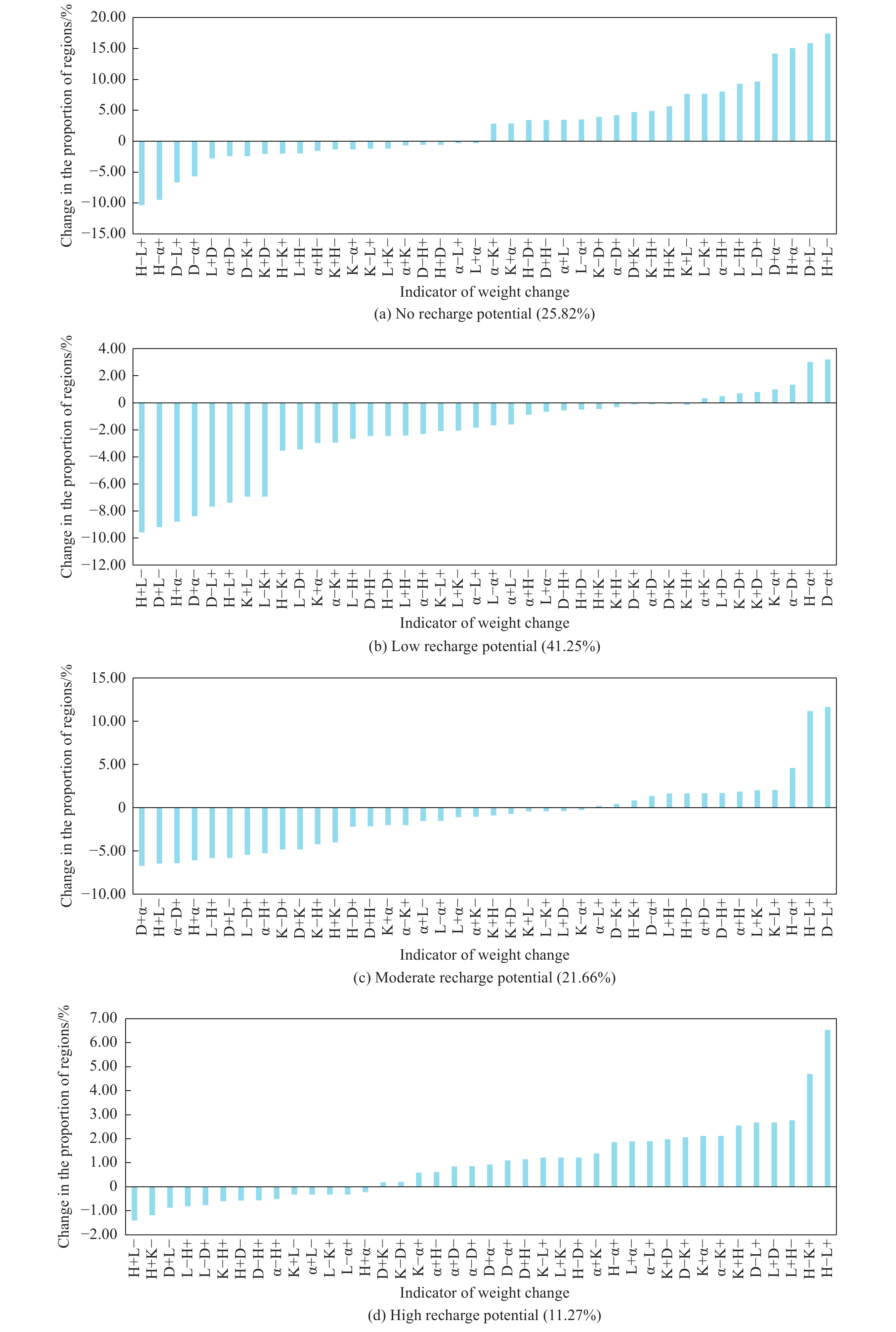
-
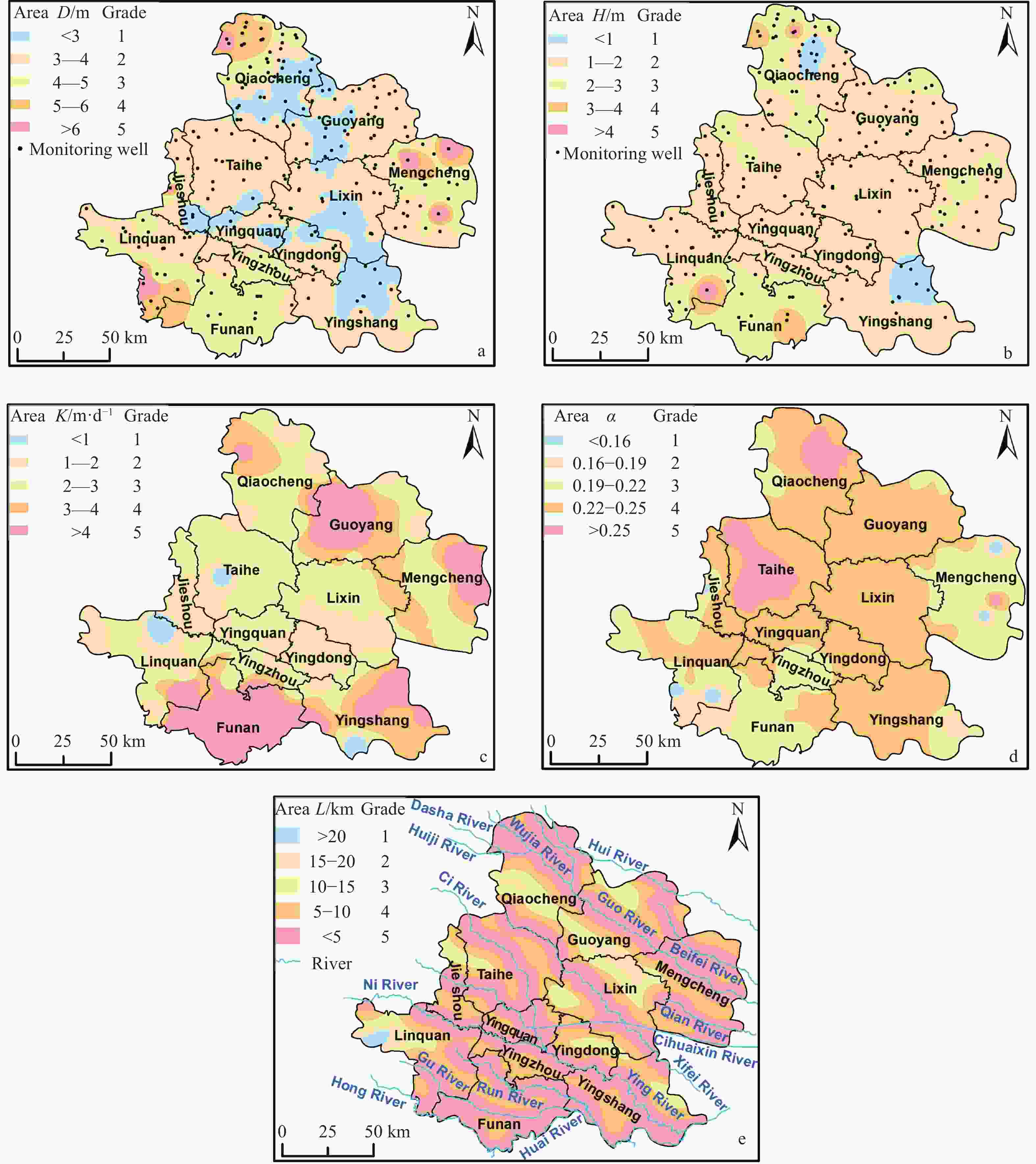
Figure 2. Indicator grading scale (a: Groundwater depth, b: Thickness of drained aquifer, c: Permeability coefficient of aquifer, d: Precipitation infiltration coefficient, e: Distance to rivers)
Table 1. Indicator scoring and grading table
Suitability Level D H K α L Grade/m Score Grade/m Score Grade/m·d−1 Score Grade Score Grade/km Score Optimal suitability >6 5 >4 5 >4 5 >0.25 5 <5 5 High suitability 5–6 4 3–4 4 3–4 4 0.22–0.25 4 5–10 4 Moderate suitability 4–5 3 2–3 3 2–3 3 0.19–0.22 3 10–15 3 Low suitability 3–4 2 1–2 2 1–2 2 0.16–0.19 2 15–20 2 No suitability <3 1 <1 1 <1 1 <0.16 1 >20 1  下载: 导出CSV
Table 2. Judgment matrix and weights for evaluation indicators
Index H D K α L Weight H 1 2 3 4 5 0.417 D 1/2 1 2 3 4 0.263 K 1/3 1/2 1 2 3 0.160 α 1/4 1/3 1/2 1 2 0.098 L 1/5 1/4 1/3 1/2 1 0.062
下载: 导出CSV
Table 3. Correlation coefficient and weight statistics table for evaluation indicators
Index D H K α L Weight D 1.00000 0.50017 0.20964 −0.60659 0.12731 0.227 H 0.50017 1.00000 0.26631 −0.37925 0.10943 0.152 K 0.20964 0.26631 1.00000 −0.26355 0.05371 0.196 α −0.60659 −0.37925 −0.26355 1.00000 −0.06245 0.269 L 0.12731 0.10943 0.05371 −0.06245 1.00000 0.156
下载: 导出CSV
Table 4. Coefficient of variation method weight statistics table
Index D H K α L Weight 0.176 0.192 0.162 0.188 0.282
下载: 导出CSV
Table 5. Coupled weight table for evaluation indicators
Index D H K α L WAHP 0.263 0.417 0.160 0.098 0.062 WCRI 0.227 0.152 0.196 0.269 0.156 WCV 0.176 0.192 0.162 0.188 0.282 W 0.222 0.254 0.173 0.185 0.166
下载: 导出CSV
Table 6. Change rates of high-potential zones
D+H− D-H+ D+K− D-K+ D+α− D-α+ D+L− D-L+ Rate 10.24% −4.95% 1.67% 18.27% 8.23% 9.77% −7.74% 23.78% H+D− H-D+ H+K− H-K+ H+α− H-α+ H+L− H-L+ Rate −5.08% 10.84% −10.44% 41.69% −1.92% 16.46% −12.42% 57.92% K+D− K-D+ K+H− K-H+ K+α− K-α+ K+L− K-L+ Rate 17.56% 1.82% 22.63% −5.31% 18.79% 5.27% −2.88% 10.79% α+D− α-D+ α+H− α-H+ α+K− α-K+ α+L− α-L+ Rate 7.55% 7.63% 5.43% −4.42% 12.31% 18.79% −2.88% 16.83% L+D− L-D+ L+H− L-H+ L+K− L-K+ L+α− L-α+ Rate 23.78% −6.75% 24.62% −7.17% 10.79% −2.88% 16.78% −2.88%
下载: 导出CSV
-
Agarwal R, Garg PK. 2016. Remote sensing and GIS based groundwater potential & recharge zones mapping using multi-criteria decision making technique. Water Resources Management, 30: 243−260. DOI: 10.1007/s11269-015-1159-8. Ajjur SB, Mogheir YK. 2019. Identification of intrinsic suitable sites in Gaza Strip for the application of artificial groundwater recharge using a geographic information system multicriteria decision analysis. Journal of Multi-Criteria Decision Analysis, 27: 255−265. DOI: 10.1002/mcda.1701. Aju CD, Achu AL, Raicy MC, et al. 2021. Identification of suitable sites and structures for artificial groundwater recharge for sustainable water resources management in Vamanapuram River Basin, South India. HydroResearch, 4: 24−37. DOI: 10.1016/j.hydres.2021.04.001. Aloui D, Chekirbane A, Stefan C, et al. 2022. Use of a GIS-multi-criteria decision analysis and web-based decision support tools for mapping and sharing managed aquifer recharge feasibility in Enfidha plain, NE of Tunisia. Arabian Journal of Geosciences, 15: 658. DOI: 10.1007/s12517-022-09893-8. Arya S, Subramani T, Karunanidhi D. 2020. Delineation of groundwater potential zones and recommendation of artificial recharge structures for augmentation of groundwater resources in Vattamalaikarai Basin, South India. Environmental Earth Science, 79: 102. DOI: 10.1007/s12665-020-8832-9. Biswas G, Garai T, Santra U. 2023. A possibility-based multi-criteria decision-making approach for artificial recharge structure selection using pentagonal fuzzy numbers. Decision Analytics Journal, 9: 100365. DOI: 10.1016/j.dajour.2023.100365. Diakoulaki D, Mavrotas G, Papayannakis L. 1995. Determining objective weights in multiple criteria problems: The critic method. Computers & Operations Research, 22: 763−770. DOI: 10.1016/0305-0548(94)00059-H. Dörr F, Bauer J, Tran HV, et al. 2023. Vietnam's mekong delta- land subsidence due to groundwater over-exploitation. Wasserwirtschaft, 113: 52−56. DOI: 10.1007/s35147-023-1922-3. Dubey RS, Chattopadhyay PB, Pal U. 2024. Identifying potential artificial recharge zone in an arid craton. Groundwater for Sustainable Development, 27: 101338. DOI: 10.1016/j.gsd.2024.101338. Fan ZR, Wang YY, OYang W, et al. 2023. Artificial groundwater recharge potential and recharge mode in the Shichuan River valley area. South-to-North Water Transfers and Water Science & Technology, 491−500. (in Chinese) DOI: 10.13476/j.cnki.nsbdqk.2023.0049. Gao W. 2013. Effect of long-distance raw water pipeline on typical water quality indicators. China Water & Wastewater, 29: 4. (in Chinese) DOI: 10.19853/j.zgjsps.1000-4602.2013.19.016. Hammouri N, Al-Amoush H, Al-Raggad M, et al. 2014. Groundwater recharge zones mapping using GIS: A case study in Southern part of Jordan Valley, Jordan. Arabian Journal of Geosciences, 7: 2815−2829. DOI: 10.1007/s12517-013-0995-1. Heng T, Chen GH. 2013. Application of hierarchical equations of motion (HEOM) to time dependent quantum transport at zero and finite temperatures. The European Physical Journal B, 86: 411. DOI: 10.1140/epjb/e2013-40333-7. Houle ES, Livneh B, Kasprzyk JR. 2017. Exploring snow model parameter sensitivity using Sobol' variance decomposition. Environmental Modelling & Software, 89: 144−158. DOI: 10.1016/j.envsoft.2016.11.024. Jamali MY, Namous M, SoumiaAmir. 2020. Impact of overexploitation of groundwater along the irrigated perimeter of Tadla, Oum Errabia Basin, Morocco. Desalination and Water Treatment, 195: 201−212. DOI: 10.5004/dwt.2020.25877. Jena S, Panda RK, Ramadas M, et al. 2020. Delineation of groundwater storage and recharge potential zones using RS-GIS-AHP: Application in arable land expansion. Remote Sensing Applications: Society and Environment, 19: 100354. DOI: 10.1016/j.rsase.2020.100354. Kadiri M, Zarhloule Y, Barkaoui A-e, et al. 2023. Identification of potential artificial groundwater recharge sites using GIS and the analytical hierarchy process: Case study of Tamellalt plain, Morocco. Hydrogeology Journal, 31: 1813−1828. DOI: 10.1007/s10040-023-02701-x. Lian H, Sun Z, Xu C, et al. 2023. Groundwater level dynamic simulation and soil salinization prediction of the closed hydrogeological unit in the arid irrigation area. Journal of Hydroinformatics, 25: 815−834. DOI: 10.2166/hydro.2023.142. Maqbool S, Singh V, Patley MK, et al. 2024. Evaluation of groundwater quality potential zones using AHP and WIOA models in Shopian District, Jammu and Kashmir, India: A GIS. Journal of Hazardous Materials Advances, 16: 100488. DOI: 10.1016/j.hazadv.2024.100488. Martelli G, Granati C, Paiero G, et al. 2014. Artificial recharge of phreatic aquifer in the Mereto Di Tomba Area (Upper Friuli Plain). Procedia Engineering (Netherlands), 89: 1241−1248. DOI: 10.1016/j.proeng.2014.11.427. Mengstie L, Nebere A, Jothimani M, et al. 2024. Landslide susceptibility assessment in Addi Arkay, Ethiopia using GIS, remote sensing, and AHP. Quaternary Science Advances, 15: 100217. DOI: 10.1016/j.qsa.2024.100217. Mishra U, Mohapatra AK, Mandal A, et al. 2023. Identification of potential artificial groundwater recharge sites in an alluvial setting: A coupled electrical resistivity tomography and sediment characterization study. Groundwater for Sustainable Development, 20: 100875. DOI: 10.1016/j.gsd.2022.100875. Mogaji KA, Omosuyi GO, Adelusi AO, et al. 2016. Application of GIS-based evidential belief function model to regional groundwater recharge potential zones Mapping in Hardrock Geologic Terrain. Environmental Processes, 3: 93−123. DOI: 10.1007/s40710-016-0126-6. Rachdi L, Abdelkrim B, Atoui M, et al. 2024. Assessment of groundwater potential recharge areas using advanced decision models and spatial data: Applied to Sbeitla aquifer system, central Tunisia. Groundwater for Sustainable Development, 27: 101316. DOI: 10.1016/j.gsd.2024.101316. Raja Shekar P, Mathew A. 2023. Assessing groundwater potential zones and artificial recharge sites in the monsoon-fed Murredu river basin, India: An integrated approach using GIS, AHP, and Fuzzy-AHP. Groundwater for Sustainable Development, 23: 100994. DOI: 10.1016/j.gsd.2023.100994. Rani M, Joshi H, Kumar K, et al. 2019. Development of recharge and conservation site suitability model for groundwater retrieval and evaluation of artificial recharge potential in a complex hydro-geological spring-fed river basin. Arabian Journal of Geosciences, 12: 589. DOI: 10.1007/s12517-019-4784-3. Sethuraman S, Alshahrani HM, Tamizhselvi A, et al. 2024. Assessment of coastal vulnerability using AHP and machine learning techniques. Journal of South American Earth Sciences, 147: 105107. DOI: 10.1016/j.jsames.2024.105107. Saaty RW. 1987a. The analytic hierarchy process—what it is and how it is used. Mathematical Modelling, 9: 161−176. DOI: 10.1016/0270-0255(87)90473-8. Saaty TL. 1983. Introduction to a modeling of social decision processes. Mathematics and Computers in Simulation, 25: 105−107. DOI: 10.1016/0378-4754(83)90072-1. Saaty TL. 1987b. How to handle dependence with the analytic hierarchy process. Mathematical Modelling, 9: 369−376. DOI: 10.1016/0270-0255(87)90494-5. Sahaar SA, Niemann JD. 2020. Impact of regional characteristics on the estimation of root-zone soil moisture from the evaporative index or evaporative fraction. Agricultural Water Management, 238: 106225. DOI: 10.1016/j.agwat.2020.106225. Salehi Shafa N, Babazadeh H, Aghayari F, et al. 2023. Optimal utilization of groundwater resources and artificial recharge system of Shahriar plain aquifer, Iran. Physics and Chemistry of the Earth, Parts A/B/C, 129: 103358. DOI: 10.1016/j.pce.2023.103358. Sandoval JA, Tiburan CL. 2019. Identification of potential artificial groundwater recharge sites in Mount Makiling Forest Reserve, Philippines using GIS and Analytical Hierarchy Process. Applied Geography, 105: 73−85. DOI: 10.1016/j.apgeog.2019.01.010. Shahkarami N. 2024. Temporal analysis of land subsidence and groundwater depletion using the DInSAR and Kriging methods: A case study and insights. Journal of Hydrologic Engineering, 29(3): 04024011. DOI: 10.1061/JHYEFF.HEENG-6130. Song X, Zhang J, Zhan C, et al. 2015. Global sensitivity analysis in hydrological modeling: Review of concepts, methods, theoretical framework, and applications. Journal of Hydrology, 523: 739−757. DOI: 10.1016/j.jhydrol.2015.02.013. Subba Rao N, Gugulothu S, Das R. 2022. Deciphering artificial groundwater recharge suitability zones in the agricultural area of a river basin in Andhra Pradesh, India using geospatial techniques and analytical hierarchical process method. Catena, 212: 106085. DOI: 10.1016/j.catena.2022.106085. Wang HY, Song CQ, Wang JF, et al. 2024. A raster-based spatial clustering method with robustness to spatial outliers. Scientific Reports, 14: 4103. DOI: 10.1038/s41598-024-53066-4. Wang YZ, Ye NJ. 2008. Farmland drainage problems in the Huaibei Plain, Anhui Province. China Rural Water and Hydropower, (2): 5–7, 13. Available on https://irrigate.whu.edu.cn/CN/Y2008/V0/I2/5 (in Chinese) Wu SJ, Tetzlaff D, Yang XQ, et al. 2022. Identifying dominant processes in time and space: Time-varying spatial sensitivity analysis for a grid-based nitrate model. Water Resources Research, 58: e2021WR031149. DOI: 10.1029/2021WR031149. Xu YY, Lü HS, Yagci A, et al. 2024. Influence of groundwater on the propagation of meteorological drought to agricultural drought during crop growth periods: A case study in Huaibei Plain. Agricultural Water Management, 305: 109122. DOI: 10.1016/j.agwat.2024.109122. Zhang YW. 2020. Evaluation of groundwater artificial recharge suitability in plain area of Daqing River Basin based on GIS - EWM. M. S. thesis, Jilin University. Zaidi FK, Nazzal Y, Ahmed I, et al. 2015. Identification of potential artificial groundwater recharge zones in Northwestern Saudi Arabia using GIS and Boolean logic. Journal of African Earth Sciences, 111: 156−169. DOI: 10.1016/j.jafrearsci.2015.07.008. Zhang H, Xu YX, Kanyerere T. 2020. A review of the managed aquifer recharge: Historical development, current situation and perspectives. Physics and Chemistry of the Earth, Parts A/B/C, 118−119: 102887. DOI: 10.1016/j.pce.2020.102887. Zhang YF, Wang YF, L, iu LX. 2001. Function mechanism between the drought and waterlogging disaster and the Soil-structure of the Shajiang soil in Huaibei Plain. Progress in Geography, 20: 169−176. (in Chinese) DOI: 10.11820/dlkxjz.2001.02.010. -

 点击查看大图
计量
- 文章访问数: 13
- HTML全文浏览量: 5
- PDF下载量: 0
- 被引次数: 0


