 E-mail alert
 Rss
Rss

Identification of groundwater potential in hard rock aquifer systems using Remote Sensing, GIS and Magnetic Survey in Veppanthattai, Perambalur, Tamilnadu
-
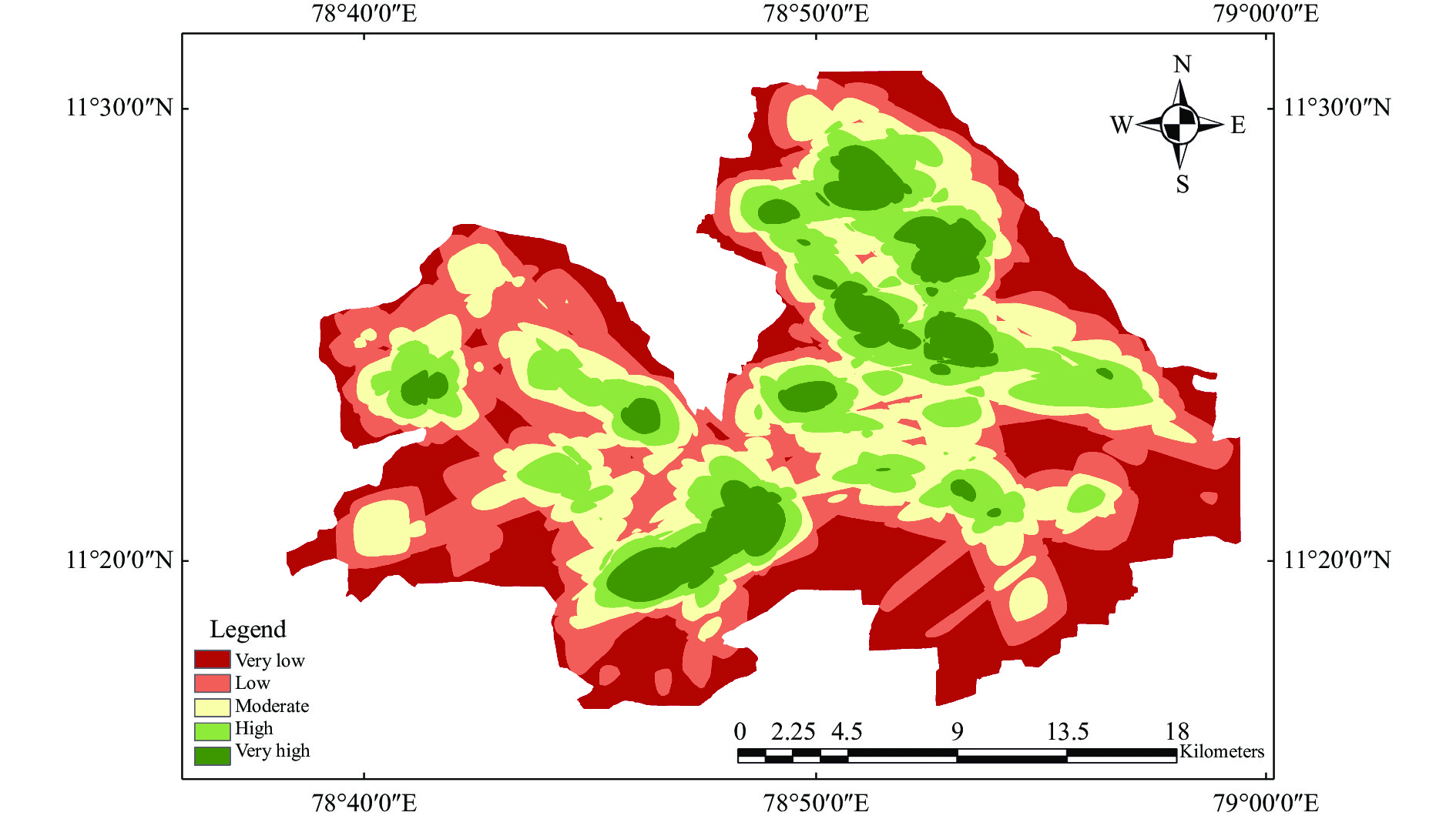
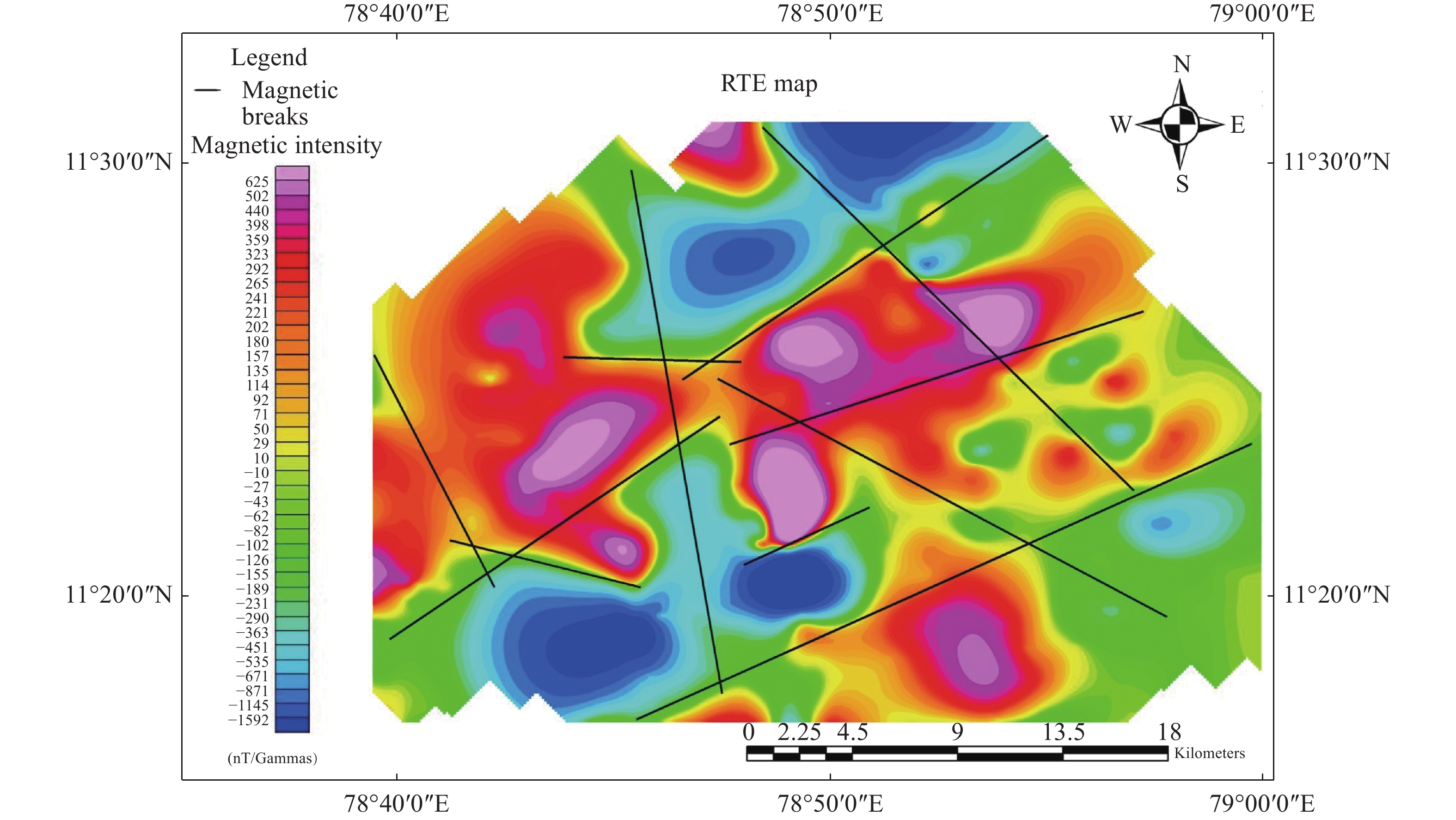
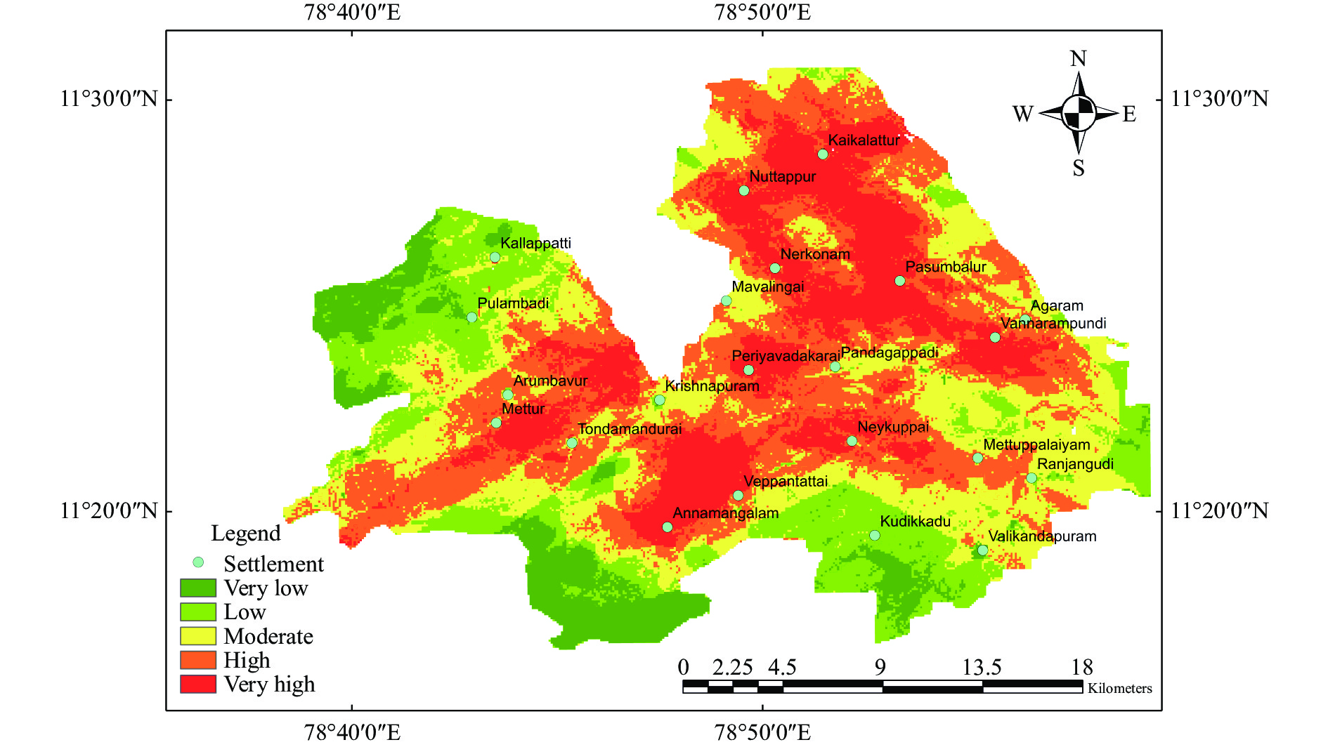
Abstract: Water is an essential natural resource without which life wouldn’t exist. The study aims to identify groundwater potential areas in Vepapanthattai taluk of Perambalur district, Tamil Nadu, India, using analytic hierarchy process (AHP) model. Remote sensing and magnetic parameters have been used to determine the evaluation indicators for groundwater occurrence under the ArcGIS environment. Groundwater occurrence is linked to structural porosity and permeability over the predominantly hard rock terrain, making magnetic data more relevant for locating groundwater potential zones in the research area. NE-SW and NW-SE trending magnetic breaks derived from reduction to pole map are found to be more significant for groundwater exploration. The lineaments rose diagram indicates the general trend of the fracture to be in the NE-SW direction. Assigned normalised criteria weights acquired using the AHP model was used to reclassify the thematic layers. As a result, the taluk’s low, moderate, and high potential zones cover 25.08%, 25.68% and 49.24% of the study area, respectively. The high potential zones exhibit characteristics favourable for groundwater infiltration and storage, with factors as gentle slope of <3°, high lineament densities, magnetic breaks, magnetic low zones as indicative of dykes and cracks, lithology as colluvial deposits and land surface with dense vegetation. The depth of the fracture zones was estimated using power spectrum and Euler Deconvolution method. The groundwater potential mapping results were validated using groundwater level data measured from the wells, which indicated that the groundwater potential zoning results are consistent with the data derived from the real world.
-
Key words:
- Groundwater exploration /
- Remote Sensing and GIS /
- Magnetic data /
- Hard rock terrain /
- Analytical hierarchy process /
- Radially averaged power spectrum
注释: -

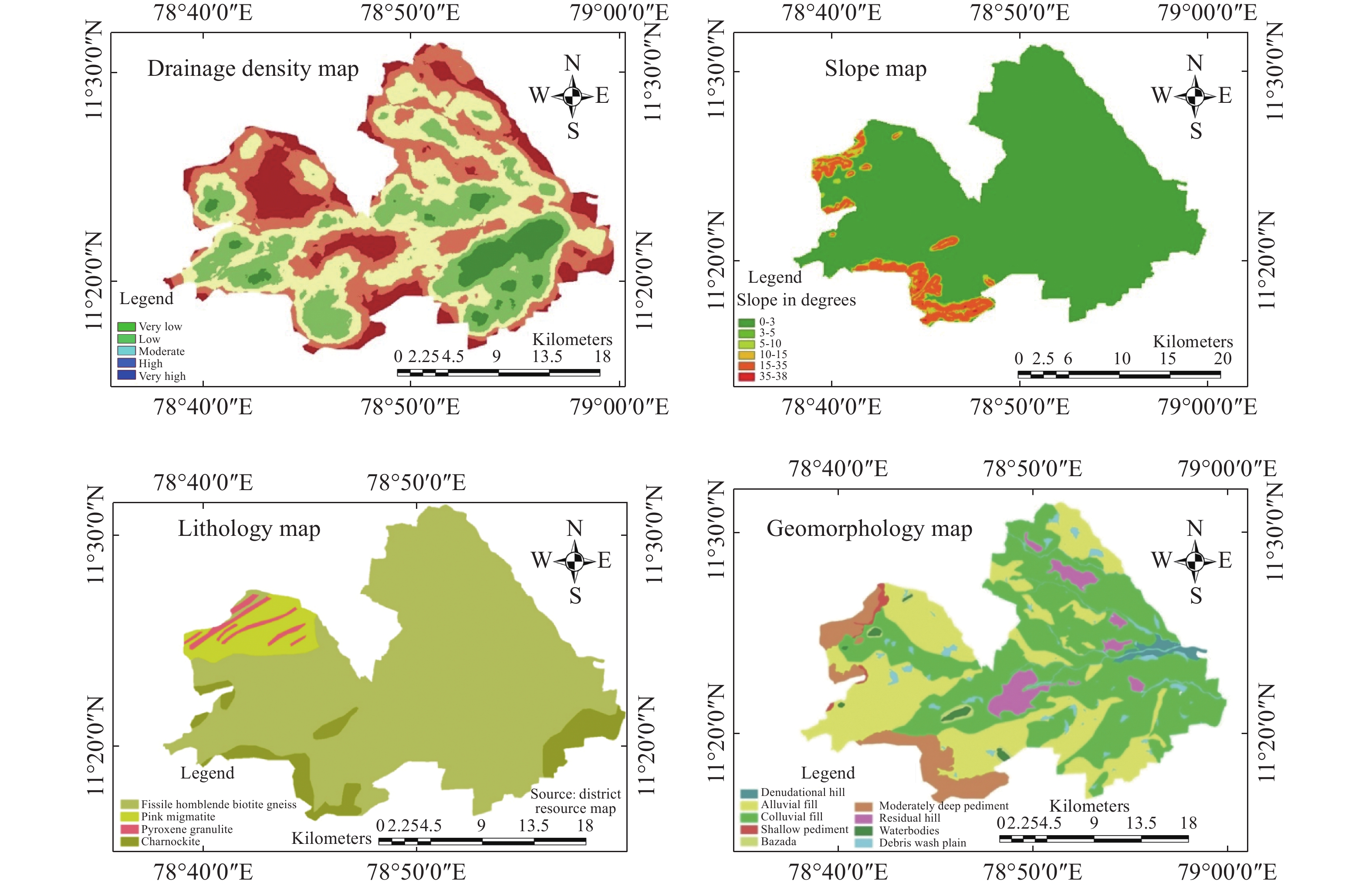
Figure 5. Drainage density, slope, geomorphology and lithology maps (clockwise from the top left)
Table 1. Lineament density and its areal size
Density range (km/km2) Density grade Size (km2) 0.00 – 0.46 Very low 145 0.46 – 0.77 Low 144 0.77 – 1.06 Moderate 132 1.06 – 1.39 High 100 1.39 – 2.08 Very High 48  下载: 导出CSV
Table 2. Drainage density and its areal size
Density range (km/km2) Density grade Size (km2) 0.12 – 1.34 Very Low 81 1.34 – 2.03 Low 161 2.03 – 2.69 Moderate 185 2.69 – 3.49 High 115 3.49 – 5.15 Very High 32
下载: 导出CSV
Table 3. Pairwise comparison matrix rating
Intensity of importance Definition Explanation 1 Equal importance Two activities contribute equally to the objective 3 Moderate importance Experience and judgment slightly favour one over another 5 Strong importance Experience and judgement strongly favour one over another 7 Very strong importance Activity is strongly favoured and its dominance is demonstrated 9 Absolute importance Importance of one over another affirmed on the highest possible order 2,4,6,8 Intermediate values Used to represent compromise between priorities listed above Reciprocal of above non-zero numbers If activity I has one of the above non-zero numbers assigned to it when compared with activity j, then j has the reciprocal value when compared with i
下载: 导出CSV
Table 4. Pairwise Comparison Matrix
Item Description LULC NDVI Wetness LD DD Lithology Soil Slope Dist to Magnetic Breaks Geomorphology LULC 1.00 1.00 1.00 0.25 0.50 2.00 3.00 2.00 0.25 0.50 NDVI 1.00 1.00 1.00 0.25 0.50 2.00 3.00 2.00 0.25 0.50 Wetness 1.00 1.00 1.00 0.25 0.50 2.00 3.00 2.00 0.25 0.50 Lineament density 4.00 4.00 4.00 1.00 2.00 6.00 7.00 6.00 1.00 2.00 Drainage density 2.00 2.00 2.00 0.50 1.00 4.00 5.00 4.00 0.50 1.00 Lithology 0.50 0.50 0.50 0.17 0.25 1.00 2.00 1.00 0.16 0.25 Soil 0.33 0.33 0.33 0.14 0.20 0.50 1.00 0.50 0.14 0.20 Slope 0.50 0.50 0.50 0.17 0.25 1.00 2.00 1.00 0.16 0.25 Dist to Magnetic Breaks 4.00 4.00 4.00 1.00 2.00 6.25 7.14 6.25 1.00 2.00 Geomorphology 2.00 2.00 2.00 0.50 1.00 4.00 5.00 4.00 0.50 1.00
下载: 导出CSV
Table 5. Normalized matrix with criteria weights
Item description LULC NDVI Wetness LD DD Lithology Soil Slope Distance to magnetic breaks Geomorphology Criteria weights LULC 0.061 0.061 0.061 0.059 0.061 0.070 0.079 0.070 0.059 0.061 0.064 NDVI 0.061 0.061 0.061 0.059 0.061 0.070 0.079 0.070 0.059 0.061 0.064 Wetness 0.061 0.061 0.061 0.059 0.061 0.070 0.079 0.070 0.059 0.061 0.064 Lineament density 0.245 0.245 0.245 0.237 0.244 0.209 0.184 0.209 0.238 0.244 0.230 Drainage density 0.122 0.122 0.122 0.118 0.122 0.139 0.131 0.139 0.119 0.122 0.126 Lithology 0.031 0.031 0.031 0.039 0.030 0.035 0.052 0.035 0.038 0.030 0.035 Soil 0.020 0.020 0.020 0.034 0.024 0.017 0.026 0.017 0.033 0.024 0.024 Slope 0.031 0.031 0.031 0.039 0.030 0.035 0.052 0.035 0.038 0.030 0.035 Distance to Magnetic breaks 0.245 0.245 0.245 0.237 0.244 0.217 0.187 0.217 0.238 0.244 0.232 Geomorphology 0.122 0.122 0.122 0.118 0.122 0.139 0.131 0.139 0.119 0.122 0.126
下载: 导出CSV
-
Aina, Adebayo. 1986. Reduction to equator, reduction to pole and orthogonal reduction of magnetic profiles. Exploration Geophysics, 17(3): 141−145. doi: 10.1071/EG986141 Kumar AV, Mondal NC, Ahmed S. 2020. Identification of groundwater potential zones using RS, GIS and AHP techniques: A case study in a part of Deccan Volcanic Province (DVP), Maharashtra, India. Journal of the Indian Society of Remote Sensing: 497−511. doi: 10.1007/s12524-019-01086-3 Anbazhagan S, Jothibasu A. 2016. Geoinformatics in groundwater potential mapping and sustainable development: A case study from southern India. Hydrological Sciences Journal, 61(6): 1109−1123. doi: 10.1080/02626667.2014.990966 Arshad A, Zulfiqar A. 2012. Integration of groundwater flow modeling and GIS. In Water Resources Management and Modeling edited by Dr. Purna Nayak. IntechOpen. Chandio IA, Matori ANB, Khamaruzaman B, et al. 2013. GIS-based analytic hierarchy process as a multicriteria decision analysis instrument: A review. Arabian Journal of Geosciences: 3059−3066. doi: 10.1007/s12517-012-0568-8 Das, Sujit. 2017. Delineation of groundwater potential zone in hard rock terrain in Gangajalghati block, Bankura district, India using remote sensing and GIS techniques. Modeling Earth Systems and Environment, 3(4): 1589−1599. doi: 10.1007/s40808-017-0396-7 Dewashish K, Krishnamurthy NS. 2006. Utility of magnetic data in delineation of groundwater potential zones in hard rock terrain. Current Science, 91: 1456−1458. Khodaei K, Nassery HR. 2013. Groundwater exploration using remote sensing and geographic information systems in a semi-arid area (Southwest of Urmieh, Northwest of Iran). Arabian Journal of Geosciences: 1229−1240. doi: 10.1007/s12517-011-0414-4 Krishnan R, Sanjay J, Gnanaseelan C, et al. 2020. Assessment of climate change over the Indian Region. 1. Springer: Singapore. doi: 10.1007/978-981-15-4327-2 Liu QS, Liu GH, Huang C, et al. 2014. A tasseled cap transformation for Landsat 8 OLI TOA reflectance images. In IEEE Geoscience and Remote Sensing Symposium: 541−544. Ma WM, Zhang XC, Zhen Q, et al. 2016. Effect of soil texture on water infiltration in semiarid reclaimed land. Water Quality Research Journal, 51(1): 33−41. doi: 10.2166/wqrjc.2015.025 Malczewski, Jacek. 1999. GIS and Multicriteria Decision Analysis. Wiley. Mallick J, Khan RA, Ahmed M, et al. 2019. Modeling groundwater potential zone in a semi-arid region of Aseer using Fuzzy-AHP and geoinformation techniques. Water, 11(12). doi: 10.3390/w11122656 Mohammadi-Behzad HR, Charchi A, Kalantari N, et al. 2019. Delineation of groundwater potential zones using remote sensing (RS), geographical information system (GIS) and analytic hierarchy process (AHP) techniques: A case study in the Leylia–Keynow watershed, southwest of Iran. Carbonates and Evaporites: 1307–1319. Muthamilselvan A, Rajasekaran N, Suresh R. 2019. Mapping of Hard rock aquifer system and artificial recharge zonation through remote sensing and GIS approach in parts of Perambalur district of Tamil Nadu, India. Journal of Groundwater Science and Engineering: 264−281. doi: 10.19637/j.cnki.2305-7068.2019.03.007 Muthamilselvan A, Srimadhi K, Nandhini. R, et al. 2017. Spatial confirmation of major lineament and groundwater exploration using Ground Magnetic Method near Mecheri Village, Salem District of Tamil Nadu, India. Journal of Geology & Geophysics. Nakamura A, Milligan PR. 2015. Total Magnetic Intensity (TMI) grid of Australia with variable reduction to pole (VRTP). Geoscience Australia. Nilawar, Waikar ML, Aditya P. 2014. Identification of groundwater potential zone using Remote Sensing and GIS technique. International Journal of Innovative Research in Science, Engineering and Technology. Pothiraj P, Baskaran R. 2013. Mapping of lineaments for groundwater targeting and sustainable water resource management in Hard Rock hydrogeological environment using RS-GIS. Climate Change and Regional/Local Responses. Prasad RK, Mondal NC, Banerjee P, et al. 2008. Deciphering potential groundwater zone in hard rock through the application of GIS. Environmental Geology, 55(3): 467−475. doi: 10.1007/s00254-007-0992-3 Saaty, Thomas L. 2014. Analytic Heirarchy Process. Wiley StatsRef: Statistics Reference Online. Saraf AK, Choudhury PR. 1998. Integrated remote sensing and GIS for groundwater exploration and identification of artificial recharge sites. International Journal of Remote Sensing, 19(10): 1825−1841. doi: 10.1080/014311698215018 Simlandy, Sagar. 2015. Importance of groundwater as compatible with environment. International Journal of Ecosystem, 5: 89−92. doi: 10.5923/c.ije.201501.13 Singh P, Thakur JK, Kumar S. 2013. Delineating groundwater potential zones in a hard-rock terrain using geospatial tool. Hydrological Sciences Journal, 58(1): 213−223. doi: 10.1080/02626667.2012.745644 Subash C, Esben A, Pradip KM, et al. 2019. Large scale mapping of fractures and groundwater pathways in crystalline hardrock by AEM. Scientific Reports: 398. doi: 10.1038/s41598-018-36153-1 Sultan A. 2013. Delineation of groundwater aquifer and subsurface structures on North Cairo, Egypt, using integrated interpretation of magnetic, gravity, geoelectrical and geochemical data. Geophysical Journal International, 192(1): 94−112. doi: 10.1093/gji/ggs008 Tanveer D, Nachiketa R, Aadil B. 2020. Delineation of potential groundwater recharge zones using analytical hierarchy process (AHP). Geology, Ecology and Landscapes. Zmuda AJ, Zmuda. 1971. The International Geomagnetic Reference Field: Introduction. Bull Int Assoc Geomag Aeronomy, 28: 148–152. -


 点击查看大图

图(9) / 表ll (5)
计量
- 文章访问数: 4287
- HTML全文浏览量: 987
- PDF下载量: 77
- 被引次数: 0


