 E-mail alert
 Rss
Rss



A signal decomposition optimized SWAT+ coupling framework for simulating groundwater response in the central plains agricultural core area: Sensitivity and land use scenarios
-
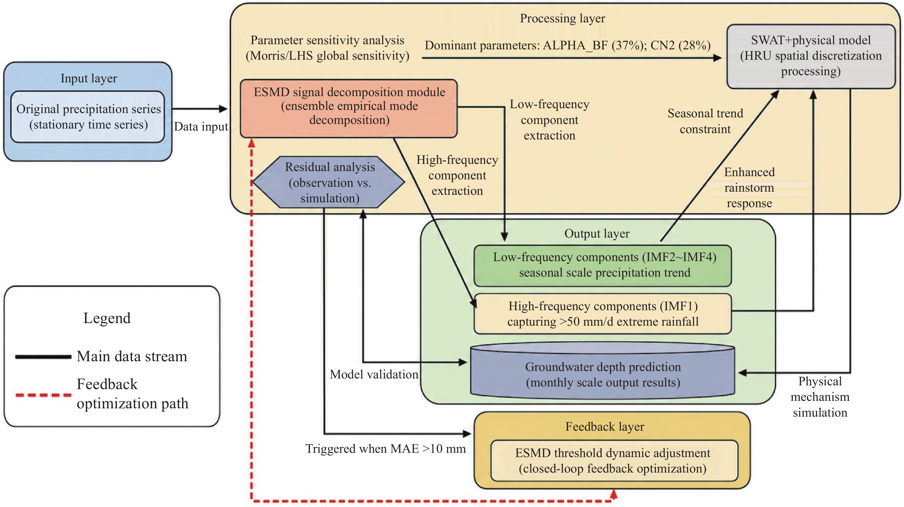
Abstract: Predicting groundwater depth is crucial for sustainable water management in agricultural regions facing intensive irrigation and rapid urbanization. Traditional data-driven models lack physical interpretability, while physical models like SWAT+ often struggle with non-stationary inputs, limiting their accuracy. This study proposes a novel Physics-Dominated Signal Decomposition Optimization (PD-SDO) framework that integrates SWAT+ with Extreme-point Symmetric Mode Decomposition (ESMD) to integrate physical mechanisms with data optimization. The framework is specifically designed for intensively managed mixed land-use regions, exemplified by the study area—a national strategic zone for agricultural development. Key innovations include: 1) ESMD-optimized inputs that extract high-frequency components (the first intrinsic mode function (Intrinsic Mode Function 1, IMF1), representing the highest-frequency component of the decomposed precipitation series) from precipitation to capture extreme rainfall pulses (>50 mm/d), thereby enhancing SWAT+'s adaptability to non-stationary climatic forcings prevalent in monsoon-influenced areas; 2) sensitivity-guided analysis identifying ALPHA_BF as the dominant parameter controlling groundwater recharge, which, combined with spatial heterogeneity analysis, reveals dual-mode drainage dynamics in loess-dominated unsaturated zones; 3) A closed-loop optimization where residual analysis dynamically adjusts ESMD thresholds, enabling model self-optimization; 4) Quantified land-use impacts showing contrasting hydrological effects under afforestation and urbanization scenarios, providing direct insights for spatial planning. The framework significantly improves simulation accuracy for groundwater depth, achieving a Nash-Sutcliffe Efficiency (NSE) of 0.94 and a Mean Absolute Error (MAE) of 8.02 m, which represents a 23% gain over the standalone SWAT+. It also enhances computational efficiency by 40% with minimal accuracy loss and provides 2.3× greater physical interpretability than pure black-box models. PD-SDO offers a replicable solution for high-fidelity groundwater modeling in rapidly changing mixed land-use zones, effectively balancing mechanistic fidelity with predictive performance. The framework and its findings provide a scientific basis for optimizing water allocation and land use management within strategic agricultural regions.
-
Key words:
- Groundwater depth /
- SWAT+ /
- Parameter sensitivity /
- Land use scenarios /
- Signal decomposition /
- Agricultural Core Area
-
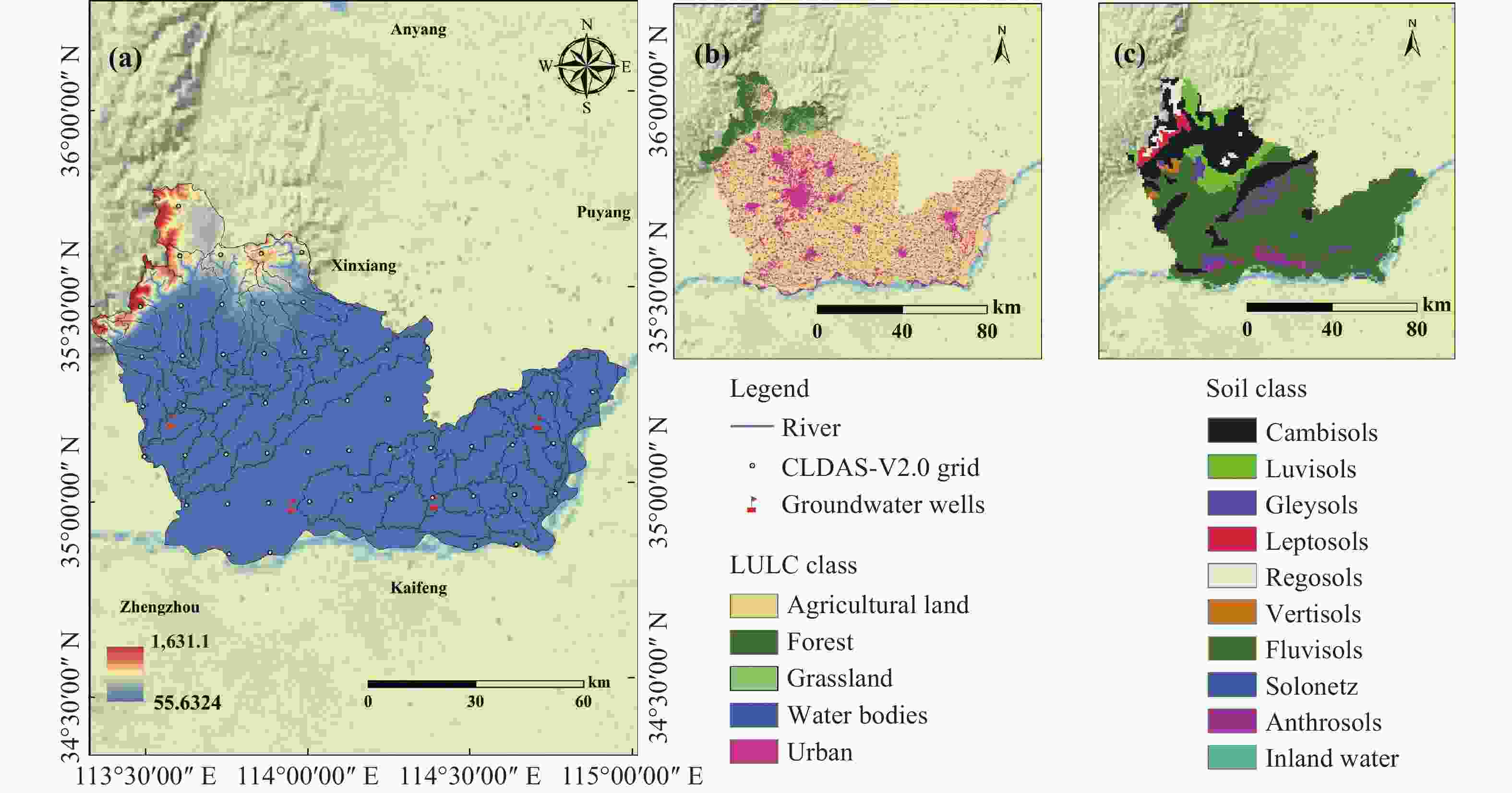
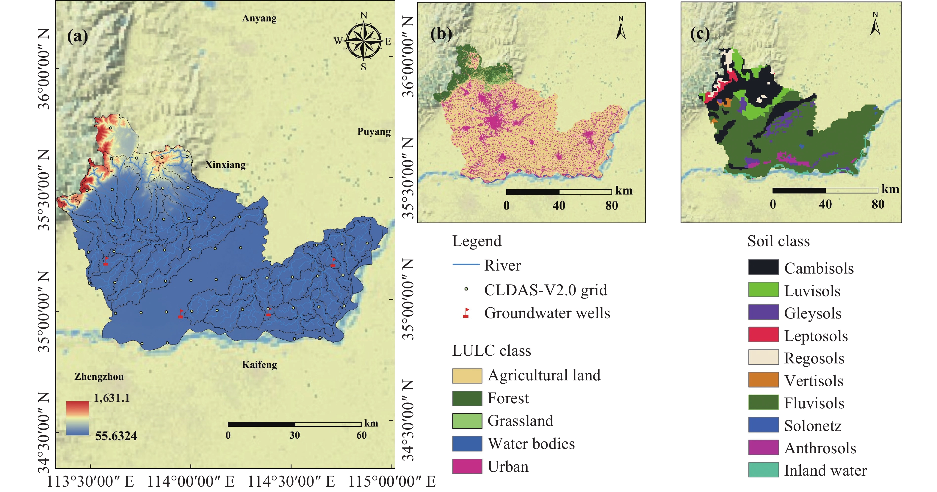
Figure 1. Study Area
Notes: (a) Location of the Yellow River Basin in China. (b) Location of the Central Plains Agricultural Core Area. (c) Boundaries, sub-basins, river network, groundwater wells, topography, and CLDSA-V2.0 grid of the Central Plains Agricultural Core Area
Table 1. Multisource datasets with spatiotemporal coverage and acquisition for the Central Plains Agricultural Core Area
Category Dataset Spatial/Temporal Resolution Time Range Source/Access Primary Application Remote Sensing Landsat-derived Land Cover Classification 30-meter spatial resolution/periodic temporal resolution 2005–2021 USGS Landsat Land use/cover mapping and analysis of changes in HRU divisions and transfer matrices Meteorology CMADS V2.0 Interpolation to HRU spatial/daily time scales 2005–2021 China Meteorological Assimilation Driving Datasets (CMADS) Weather Inputs to SWAT+ Models to Enhance Model Drivers Meteorology Meteorological station precipitation data Point space/daily time scale 2005–2021 Weather stations Precipitation sequence preprocessing Soil Harmonized World Soil Database (HWSD) 1 km spatial resolution/static time scale 2012 FAO/IIASA Soil physical properties extracted using the ROSETTA soil transfer function Hydrology Groundwater depth monitoring Point scale (4 monitoring wells)/monthly time scale 2005–2021 Field monitoring wells Model calibration, validation and residual analysis; quantifying the response of land use and climate change to groundwater depth Land Use Land use/cover change data 30-meter spatial resolution/periodic time scale 2005–2021 Landsat classification (Kappa coefficient 0.89) Quantification of land-use change impacts and policy-relevant simulations in SWAT+  下载: 导出CSV
Table 2. Land use type transition matrix for the central plains agricultural core area (2005–2021, km2)
Beginning of the period/End of the period AGRL FRST PAST WATR URBN AGRL 8214.5 1032.7 687.3 42.1 1586.2 FRST 318.9 5617.3 423.6 9.7 187.4 PAST 594.2 873.5 4215.8 22.4 323.6 WATR 18.7 7.3 9.1 83.9 11.2 URBN 23.5 15.2 18.4 1.9 1305.6
下载: 导出CSV
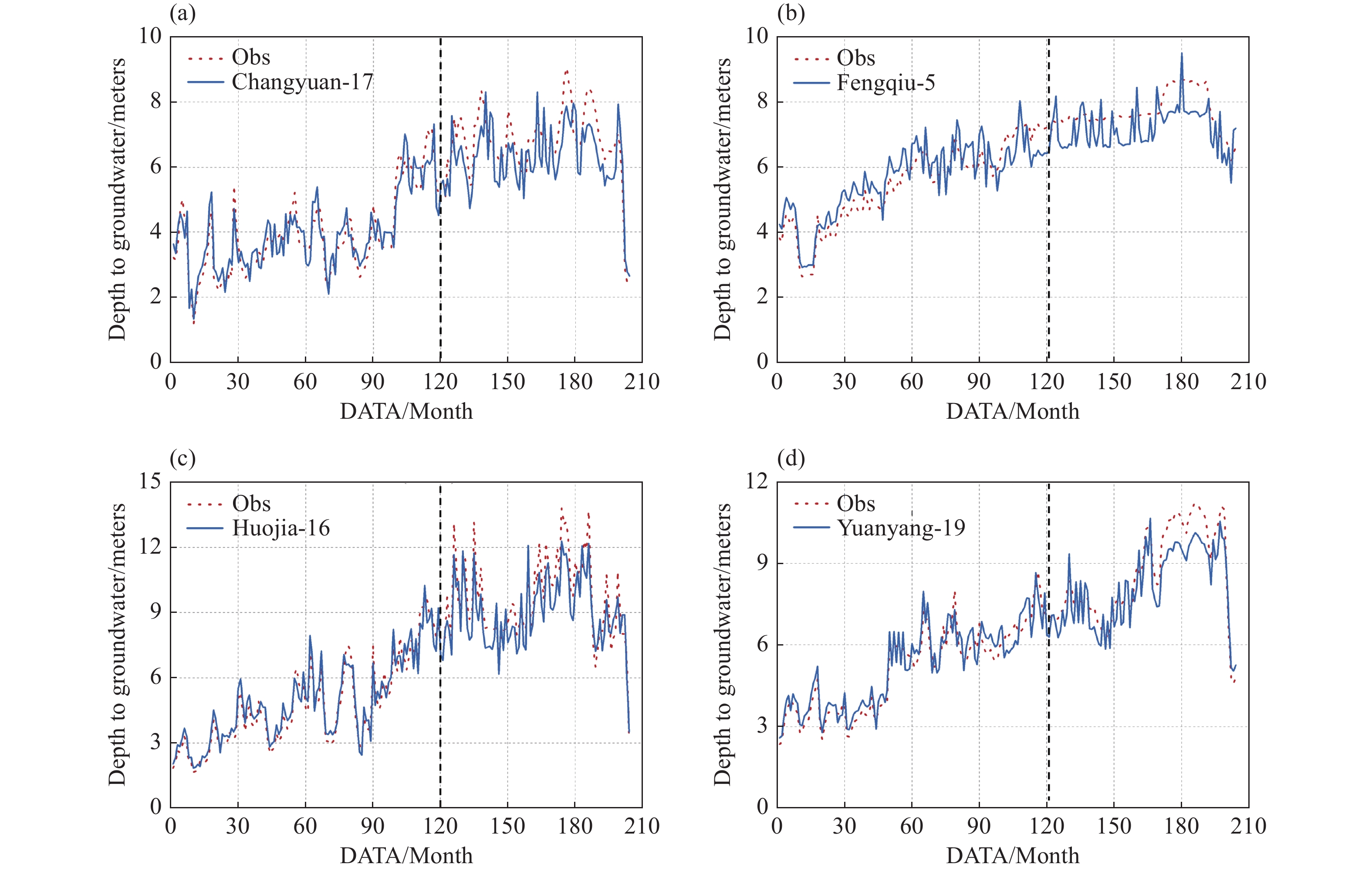
Table 3. Spatial distribution of model residuals during the validation period (2015-2021)
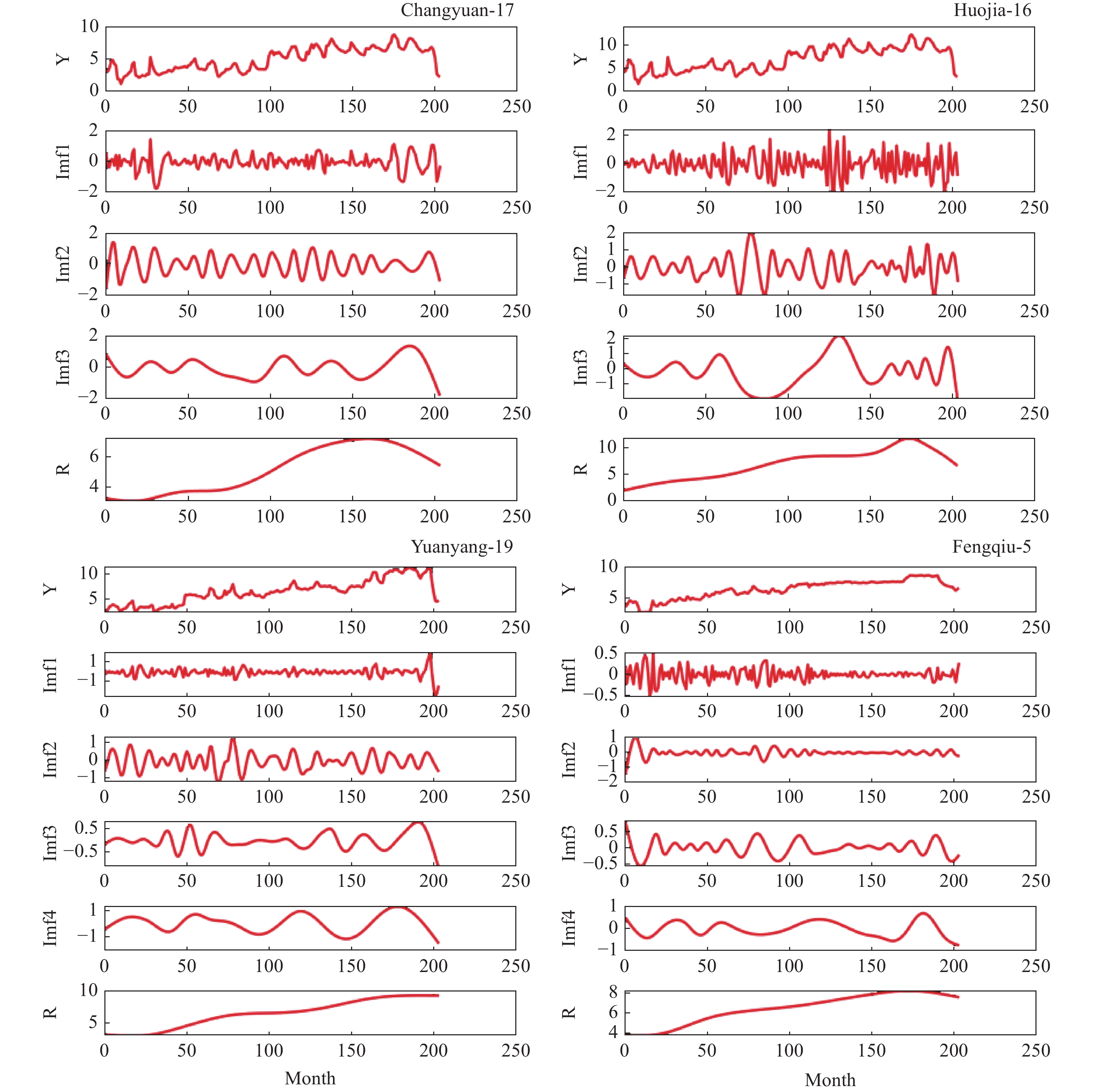
Monitoring well location Lithology type Average residual (m) Main sources of deviation Improvement measures Changyuan-17 Clay +0.38 Irrigation flow disturbance not quantified Embedded irrigation module parameter optimization Huojia-16 Powdery loam +0.12 Urban pipeline leakage not considered Sewer leakage coefficient added Yuanyang-19 Sandy loam −0.24 Vegetation transpiration underestimated Dynamic Vegetation Module Upgrade Fengqiu-5 Gravelly loam −0.07 Bedrock fissure flow not characterized Addition of fissure flow sub-model
下载: 导出CSV
-
Abbas SA, Bailey RT, White JT, et al. 2024. A framework for parameter estimation, sensitivity analysis, and uncertainty analysis for holistic hydrologic modeling using SWAT+. Hydrology and Earth System Sciences, 28(1): 21−48. DOI: 10.5194/hess-28-21-2024. Abbas SA, White JT, Almahawis MK, et al. 2025. Dual-phase calibration for surface–subsurface hydrologic models with diverse hydrologic conditions. Journal of Hydrologic Engineering, 30(4): 04025019. DOI: 10.1061/JHYEFF.HEENG-6479. Bawa A, Mendoza K, Srinivasan R, et al. 2025. Enhancing hydrological modeling of ungauged watersheds through machine learning and physical similarity-based regionalization of calibration parameters. Environmental Modelling & Software, 186: 106335. DOI: 10.1016/j.envsoft.2025.106335. Chen S, Fu YH, Wu Z, et al. 2023. Informing the SWAT model with remote sensing detected vegetation phenology for improved modeling of ecohydrological processes. Journal of Hydrology, 616: 128817. DOI: 10.1016/j.jhydrol.2022.128817. Costa RCA, Santos RMB, Fernandes LFS, et al. 2023. Hydrologic response to land use and land cover change scenarios: An example from the Paraopeba River Basin based on the SWAT model. Water, 15(8): 1451. DOI: 10.3390/w15081451. Dai J, Pan L, Deng Y, et al. 2025. Modified SWAT model for agricultural watershed in Karst Area of Southwest China. Agriculture, 15(2): 192. DOI: 10.3390/agriculture15020192. Gu X, Long A, He X, et al. 2024. Response of runoff to climate change in the Manas River Basin flow-producing area, Northwest China. Applied Water Science, 14(3): 43. DOI: 10.1007/s13201-023-02099-7. Huang NE, Shen Z, Long SR, et al. 1998. The empirical mode decomposition and the Hilbert spectrum for nonlinear and non-stationary time series analysis. Proceedings of the Royal Society of London. Series A: Mathematical, Physical and Engineering Sciences, 454(1971): 903−995. DOI: 10.1098/rspa.1998.0193. Jahanshahi A, Asadi H, Gupta H. 2025. A data fusion approach to enhancing runoff simulation in a semi-arid river basin. Environmental Modelling & Software, 190: 106468. DOI: 10.1016/j.envsoft.2025.106468. Jeong H, Lee B, Kim D, et al. 2024. Improving estimation capacity of a hybrid model of LSTM and SWAT by reducing parameter uncertainty. Journal of Hydrology, 633: 130942. DOI: 10.1016/j.jhydrol.2024.130942. Luo Y, Chen J, Gao S, et al. 2017. Stability analysis of super-large-section tunnel in loess ground considering water infiltration caused by irrigation. Environmental Earth Sciences, 76(22): 763. DOI: 10.1007/s12665-017-7106-7. Ma J, Li Z, Ma B, et al. 2020. Determination of groundwater recharge mechanisms using stable isotopes in small watersheds of the Loess Plateau, China. Hydrogeology Journal, 29(2): 765−781. DOI: 10.1007/s10040-020-02253-4. Mosbahi M, Kassouk Z, Benabdallah S, et al. 2023. Modeling hydrological responses to land use change in Sejnane Watershed, Northern Tunisia. Water, 15(9): 1737. DOI: 10.3390/w15091737. Nguyen TV, Dietrich J, Dang TD, et al. 2022. An interactive graphical interface tool for parameter calibration, sensitivity analysis, uncertainty analysis, and visualization for the Soil and Water Assessment Tool. Environmental Modelling & Software, 156: 105497. DOI: 10.1016/j.envsoft.2022.105497. Re V, De Filippis G, Viaroli S, et al. 2020. Groundwater (Freeze and Cherry, 1979), ora disponibile anche in italiano. Acque Sotterranee - Italian Journal of Groundwater, 9(1): 89−90. DOI: 10.7343/as-2020-453. Rivera-Fernandez AS, Cotrina-Sanchez A, Salas López R, et al. 2025. Spatiotemporal land cover change and future hydrological impacts under climate scenarios in the Amazonian Andes: A case study of the Utcubamba River Basin. Land, 14(6): 1234. DOI: 10.3390/land14061234. Rong Y, Zeng S, Qin C, et al. 2024. Holistic parameter sensitivity: A new perspective to address the risk brought by multi-source deep uncertainty on watershed management. Journal of Environmental Management, 372: 122983. DOI: 10.1016/j.jenvman.2024.122983. Sang S, Li L. 2024. A stock prediction method based on heterogeneous bidirectional LSTM. Applied Sciences, 14(20): 9158. DOI: 10.3390/app14209158. Shishegar S, Ghorbani R, Saad Saoud L, et al. 2021. Rainfall–runoff modelling using octonion-valued neural networks. Hydrological Sciences Journal, 66(13): 1857−1865. DOI: 10.1080/02626667.2021.1962885. Shukla S, Meshesha TW, Sen IS, et al. 2023. Assessing impacts of Land Use and Land Cover (LULC) change on stream flow and runoff in Rur Basin, Germany. Sustainability, 15(12): 9811. DOI: 10.3390/su15129811. Talebizadeh M, Moriasi DN, Steiner JL, et al. 2024. Spatio-temporal sensitivity analysis for flow and sediment load modeling using SWAT in a heterogeneous agricultural watershed. Water Resources Management, 39(5): 2281−2298. DOI: 10.1007/s11269-024-04066-6. Valencia S, Villegas JC, Hoyos N, et al. 2024. Streamflow response to land use/land cover change in the tropical Andes using multiple SWAT model variants. Journal of Hydrology: Regional Studies, 54: 101888. DOI: 10.1016/j.ejrh.2024.101888. Wang JL, Li ZJ. 2013. Extreme-point symmetric mode decomposition method for data analysis. Advances in Adaptive Data Analysis, 5(3): 1350015. DOI: 10.1142/S1793536913500155. Wang K, Tan W, Si Y, et al. 2024. A solute transport in deformable dual-porosity media using mixture-coupling theory. Environmental Geotechnics, 11(3): 165−179. DOI: 10.1680/jenge.22.00029. Wu S, Dong Z, Guzmán SM, et al. 2024. Two-step hybrid model for monthly runoff prediction utilizing integrated machine learning algorithms and dual signal decompositions. Ecological Informatics, 84: 102914. DOI: 10.1016/j.ecoinf.2024.102914. Yilmaz AG, Muttil N, Adhikary SK. 2018. Improving streamflow forecast using optimal rain gauge network-based input to artificial neural network models. Hydrology Research, 49(5): 1559−1577. DOI: 10.2166/nh.2017.108. Yu H, Wen X, Feng Q, et al. 2017. Comparative study of hybrid-wavelet artificial intelligence models for monthly groundwater depth forecasting inextreme arid regions, Northwest China. Water Resources Management, 32(1): 301−323. DOI: 10.1007/s11269-017-1811-6. Zhang Q, Wu J, Liu W, et al. 2025. SWAT+ model enhanced with dynamic phenology remote sensing and high-precision precipitation data for water resource vulnerability assessment in semi-arid regions. Water Resources Management, 39(10): 4947−4969. DOI: 10.1007/s11269-025-04182-x. -


 点击查看大图
计量
- 文章访问数: 10
- HTML全文浏览量: 4
- PDF下载量: 0
- 被引次数: 0


