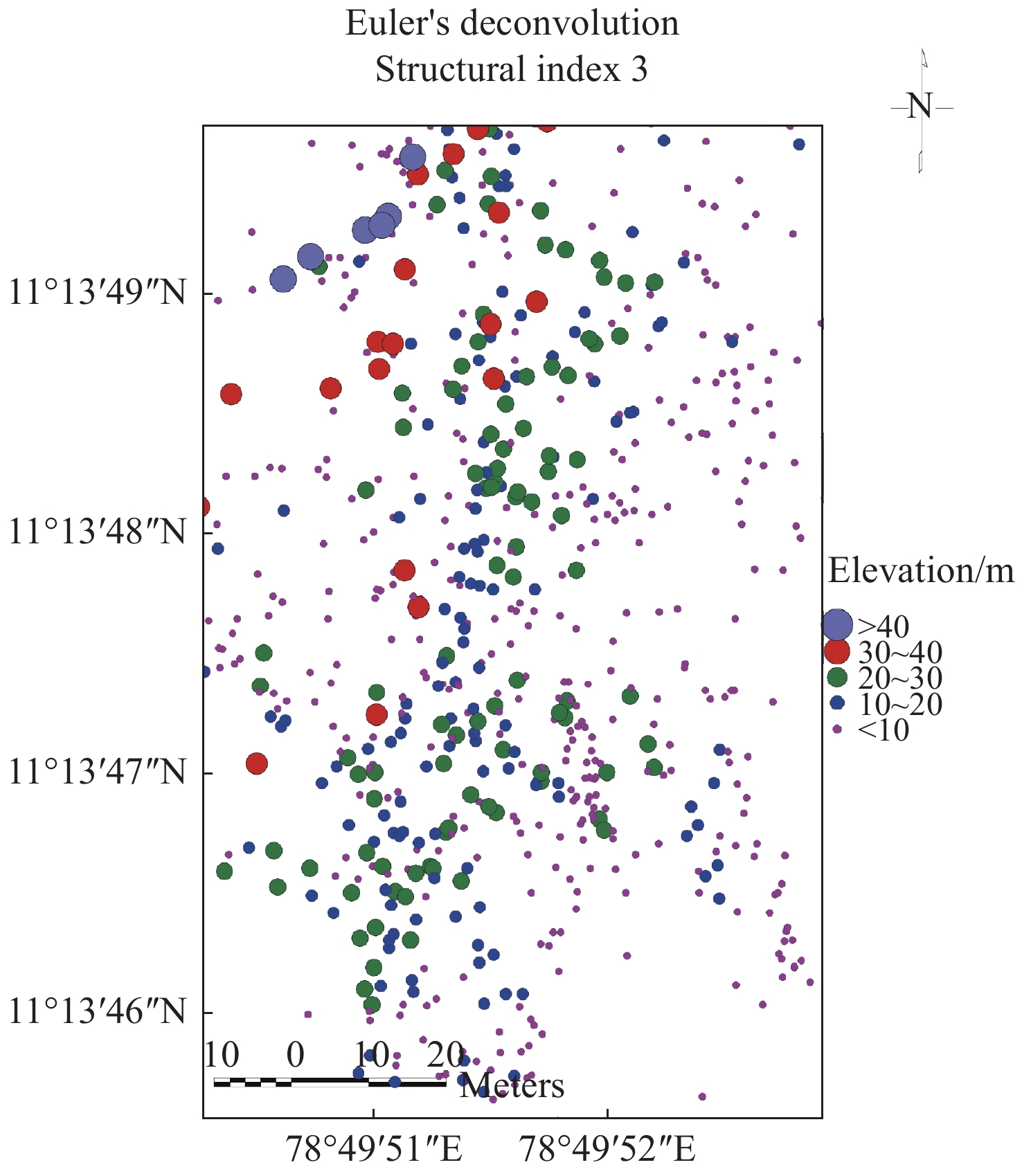
| Citation: | A Muthamilselvan. 2021: Identification of suitable sites for open and bore well using ground magnetic survey. Journal of Groundwater Science and Engineering, 9(3): 256-268. doi: 10.19637/j.cnki.2305-7068.2021.03.008

|

|
Adagunodo TA, Sunmonu A, Adeniji A. 2015. An overview of magnetic method in mineral exploration. Journal of Global Ecology and Environment, 3(1): 13-28.
|
|
Daniel CU, Chimezie CO, SA Ugwu. 2018. Spectral analysis and euler deconvolution of regional aeromagnetic data to delineate sedimentary thickness in Mmaku Area, SouthEastern Nigeria. An international scientific journal, World Scientific News, 109: 26-42.
|
|
Dransfield MH, Buckingham MJ, van Kann FJ. 2018. Lithological Mapping by Correlating Magnetic and Gravity Gradient Airborne Measurements. Journal Exploration Geophysics, 25(1): 25-30.
|
|
Garcia JG, Ness GE. 1994. Inversion of the power spectrum from magnetic anomalies. Geophysics, 59: 391-400. doi: 10.1190/1.1443601
|
|
Grant FS, Dodds J. 1972. MAGMAP FFT processing system development notes: Paterson, Grant and Watson Limited.
|
|
Hansen RO, Racic L, Grauch VJS. 2005. Magnetic methods in near-surface geophysics. In Near-Surface Geophysics. Society of Exploration Geophysicists Press: 151-175.
|
|
Muthamilselvan A, Srimadhi K, Nandhini R, et al. 2017. Spatial confirmation of major lineament and groundwater exploration using ground magnetic method near Mecheri Village, Salem District of Tamil Nadu, India. Journal of Geology & Geophysics, 6(1): 1-10. doi: 10.4172/2381-8719.1000274
|
|
MacLeod IN, Jones K, Dai TF. 1993. 3-D analytic signal in the interpretation of total magnetic field data at low magnetic latitudes. Exploration Geophysics, 24(4): 679-688.
|
|
Nabighian MN. 1972. The analytic signal of two-dimensional magnetic bodies with polygonal cross-section: Its properties and use for automated anomaly interpretation. Geophysics, 37: 507-517. doi: 10.1190/1.1440276
|
|
Nabighian MN, Grauch VJS, Hansen RO, et al. 2005. The historical development of the magnetic method in exploration. Geophysics, 70: 33-61.
|
|
Reid AB, Allsop JM, Granser H, et al. 1990. Magnetic interpretation in three dimensions using Euler Deconvolution. Geophysics, 55: 80-90. doi: 10.1190/1.1442774
|
|
Serguel A Goussev, Jhon W Pierce. 2000. Gravity and magnetic exploration lexicon, acquisition, processing, interpretation and Imaging. Geophysical Exploration & Development Corporation: 1-157.
|
|
Spector A, Grant FS. 1970. Statistical models for interpreting aeromagnetic data. Geophysics, 35: 293-302. doi: 10.1190/1.1440092
|
|
Sultan AA. 2015. Integrated geophysical interpretation on the groundwater aquifer (At the North Western Part of Sinai, Egypt). International Journal of Innovative Science, Engineering & Technology, 2(12): 501-522.
|
|
Tatiana FQ, Angelo S. 1998. Exploration of a lignite bearing in Northern Ireland, using Maurizio ground magnetic. Geophysics, 62(4): 1143-1150.
|
|
Thompson DT. 1982. EULDPH–a new technique for making computer-assisted depth estimates from magnetic data. Geophysics, 47: 31-37. doi: 10.1190/1.1441278
|
|
Tsiboah T. 2002. 2D Resistivity and Time-Domain EM in aquifer mapping: A case study, north of Lake Naivasha, Kenya. Applied Geophysics, ITC. Netherlands: 110.
|
|
UNESCO. 1998. Unesco handbook for ground water investigations. Technical report, ITC. Netherlands.
|
| [1] | Chu Yu, Ze-peng Zhang, Yi-long Zhang, Heng-xin Zhang, Xiao-han Li, 2026: Assessment of the natural background levels of ammonia nitrogen and chloride in alluvial fan groundwater using an improved pre-selection method: Implications for groundwater management, Journal of Groundwater Science and Engineering, 14, 148-164. doi: 10.26599/JGSE.2026.9280076 |
| [2] | Bing-bing Liu, Lin Zhang, Ke Li, 2026: Precision and trueness of a method for determing antimony content in groundwater using hydride generation-atomic fluorescence spectrometry, Journal of Groundwater Science and Engineering, 14, 49-58. doi: 10.26599/JGSE.2026.9280071 |
| [3] | Adla Andalu, M Gopal Naik, Sandeep Budde, 2026: AI and ML in groundwater exploration and water resources management: Concepts, methods, applications, and future directions, Journal of Groundwater Science and Engineering, 14, 100-122. doi: 10.26599/JGSE.2026.9280059 |
| [4] | Tran Vu Long, Nguyen Bach Thao, Dao Duc Bang, Kieu Thi Van Anh, Vu Thu Hien, Duong Thi Thanh Thuy, Tran Quang Tuan, Nguyen Van Hoang, Doan Anh Tuan, Dang Tran Trung, 2025: Application of the cumulative rainfall departure method in determination of deep groundwater recharge in Soc Trang Province, Vietnam, Journal of Groundwater Science and Engineering, 13, 180-192. doi: 10.26599/JGSE.2025.9280048 |
| [5] | Masoud H Hamed, Rebwar N Dara, Marios C Kirlas, 2024: Groundwater vulnerability assessment using a GIS-based DRASTIC method in the Erbil Dumpsite area (Kani Qirzhala), Central Erbil Basin, North Iraq, Journal of Groundwater Science and Engineering, 12, 16-33. doi: 10.26599/JGSE.2024.9280003 |
| [6] | Cheng-peng Ling, Qiang Zhang, 2024: Exploring the groundwater response to rainfall in a translational landslide using the master recession curve method and cross-correlation function, Journal of Groundwater Science and Engineering, 12, 237-252. doi: 10.26599/JGSE.2024.9280018 |
| [7] | Jia-xing Sun, Gao-fan Yue, Wei Zhang, 2023: Simulation of thermal breakthrough factors affecting carbonate geothermal-to-well systems, Journal of Groundwater Science and Engineering, 11, 379-390. doi: 10.26599/JGSE.2023.9280030 |
| [8] | Rustadi, I Gede Boy Darmawan, Nandi Haerudin, Agus Setiawan, Suharno, 2022: Groundwater exploration using integrated geophysics method in hard rock terrains in Mount Betung Western Bandar Lampung, Indonesia, Journal of Groundwater Science and Engineering, 10, 10-18. doi: 10.19637/j.cnki.2305-7068.2022.01.002 |
| [9] | A Muthamilselvan, B Preethi, 2022: Spatial confirmation of termite mounds as Bio-geo indicator for groundwater occurrences using ground magnetic survey: A case study from Perambalur Region of Tamil Nadu, India, Journal of Groundwater Science and Engineering, 10, 184-195. doi: 10.19637/j.cnki.2305-7068.2022.02.007 |
| [10] | Muthamilselvan A Dr, Sekar Anamika, Ignatius Emmanuel, 2022: Identification of groundwater potential in hard rock aquifer systems using Remote Sensing, GIS and Magnetic Survey in Veppanthattai, Perambalur, Tamilnadu, Journal of Groundwater Science and Engineering, 10, 367-380. doi: 10.19637/j.cnki.2305-7068.2022.04.005 |
| [11] | Han Zhang, Zong-yu Chen, Chang-yuan Tang, 2021: Quantifying groundwater recharge and discharge for the middle reach of Heihe River of China using isotope mass balance method, Journal of Groundwater Science and Engineering, 9, 225-232. doi: 10.19637/j.cnki.2305-7068.2021.03.005 |
| [12] | Zhi-yuan LIU, Ding TAN, Zhi-bin CHEN, Yun-fei WEI, Quan CHAI, Xiao-hang CHEN, 2020: Study on multiple induced polarization parameters in groundwater exploration in Bashang poverty alleviation area of Heibei Province, China, Journal of Groundwater Science and Engineering, 8, 274-280. doi: 10.19637/j.cnki.2305-7068.2020.03.007 |
| [13] | A S El-Hames, 2020: Development of a simple method for determining the influence radius of a pumping well in steady-state condition, Journal of Groundwater Science and Engineering, 8, 97-107. doi: 10.19637/j.cnki.2305-7068.2020.02.001 |
| [14] | GUO Jin-xing, GRAEBER Peter-Wolfgang, 2018: Landslide forecasting based on hydrological process simulation for a dump slope in an open mining pit, Journal of Groundwater Science and Engineering, 6, 92-103. doi: 10.19637/j.cnki.2305-7068.2018.02.003 |
| [15] | CAO Yan-ling, CHENG Gang-jian, ZHAO Cheng-liang, WANG Tao, JIANG Hai-yang, 2018: Application of CSAMT in hydrogeology exploration in Shandong Province–An example from geothermal exploration in Changdao County (south four islands), Journal of Groundwater Science and Engineering, 6, 58-64. doi: 10.19637/j.cnki.2305-7068.2018.01.007 |
| [16] | SONG Hong-wei, MU Hai-dong, XIA Fan, 2018: Analyzing the differences of brackish-water in the Badain Lake by geophysical exploration method, Journal of Groundwater Science and Engineering, 6, 187-192. doi: 10.19637/j.cnki.2305-7068.2018.03.004 |
| [17] | ZHOU Yang-xiao, Parvez Sarwer Hossain, Nico van der Moot, 2015: Analysis of travel time, sources of water and well protection zones with groundwater models, Journal of Groundwater Science and Engineering, 3, 363-374. |
| [18] | ZHANG Shao-cai, LIU Li-jun, LIU Zhi-gang, WANG Jun-jie, CUI Qiu-ping, WANG Juan, 2014: Method for groundwater research in bedrock of mountainous area of Hebei, Journal of Groundwater Science and Engineering, 2, 97-104. |
| [19] | , 2014: The Experimental Investigations on Motion Features of Groundwater Flow near the Pumping Well, Journal of Groundwater Science and Engineering, 2, 1-11. |
| [20] | Lihe Yin, Hongyun Ma, Jiaqiu Dong, Xiaoyong Wang, Ying Li, 2013: Using a Particle Tracking Method to Quantify Groundwater Circulation rates: a Case Study in the Ordos Plateau, Journal of Groundwater Science and Engineering, 1, 97-101. |

Figures(21) / Tables(4)
Supported by:
Beijing Renhe Information Technology Co. Ltd


 E-mail alert
 Rss
Rss


 DownLoad: