| Citation: | Pandi D, Kumarasamy MV, Meyyappan P, Rajasekaran MP, Rajesh K. 2026: Estimation of the water potential index under dynamic hydromorphological conditions on ephemeral river watersheds. Journal of Groundwater Science and Engineering, 14(4): 555-581. doi: 10.26599/JGSE.2026.9280094

|
| Major terms | |
| Aster-GDEM v3 | Advanced Spaceborne Thermal Emission and Reflection Radiometer Global Digital Elevation Model Version 3 |
| AHP | Analytical Hierarchy Process |
| GIS | Geographic Information System |
| GSI | Geological Survey of India |
| GPI | Groundwater Potential Index |
| LULC | Land Use/Land Cover |
| MCDM | Multi-Criteria Decision-Making |
| NBSS- LUP | National Bureau of Soil Survey-Land Use Planning |
| PERSIANN | Precipitation Estimation from Remotely Sensed Information using Artificial Neural Networks |
| ROC | Receiver Operating Characteristic |
| SWAT | Soil and Water Assessment Tool |
| SWPI | Surface Water Potential Index |
| VGV | Vaigai, Gundar, and Vaippar |
| Notations | |
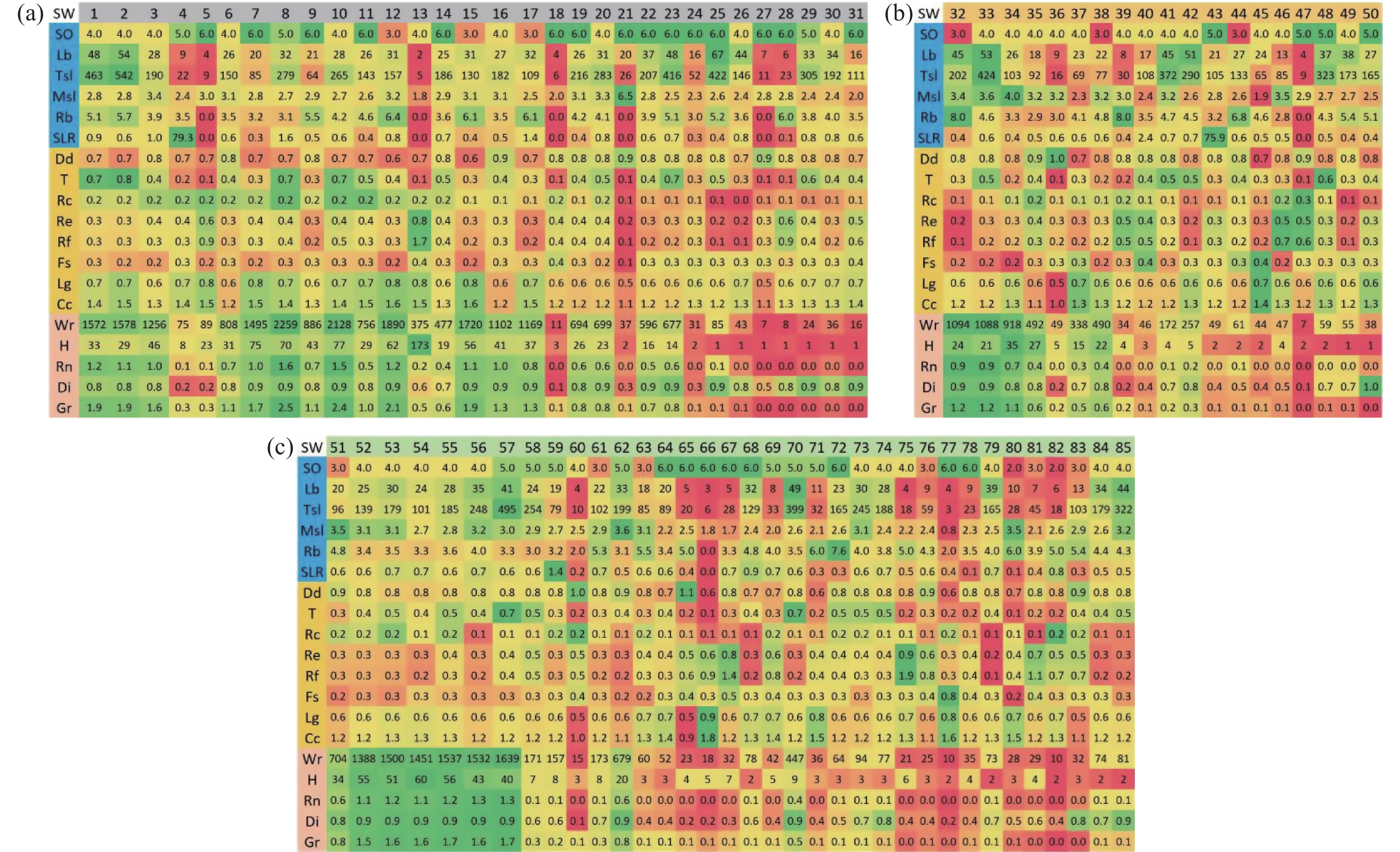
| Cc | Constant Channel Maintenance |
| Dd | Drainage density |
| Di | Dissection index |
| Fs | Stream frequency |
| Gr | Gradient Ratio |
| H | Relief ratio |
| Lb | Watershed length |
| Lg | Length of overland flow |
| Msl | Mean stream length |
| O | Stream order |
| Rb | Mean Bifurcation ratio |
| Rc | Circulatory ratio |
| Re | Elongation ratio |
| Rf | Form factor |
| Rn | Ruggedness number |
| SLR | Stream length ratio |
| T | Drainage texture |
| Tsl | Total stream length |
| Wr | Watershed relief |
| CR | Consistency Ratio |
| Ci | Consistency Index |
| Ri | Random Index |
| NR | Normalized Weight |
| GM | Geometric Mean |
| FM | Fuzzy Mean Matrix |
| FNR | Fuzzy Normalized Weight |
| WNR | Overall Normalized Weight Index |
| Greek letter | |
| λ | eigenvalues of thematic data |
| Subscripts | |
| n | number of thematic classes |
| f | Fuzzy sets |
| I | Index for Consistency Index and Random Index |

|
Abrams M, Yamaguchi Y, Crippen R. 2022. Aster Global Dem (Gdem) Version 3. The international archives of the photogrammetry, remote sensing and spatial information sciences - ISPRS archives, 43(B4-2022): 593–598. DOI: 10.5194/isprs-archives-XLIII-B4-2022-593-2022.
|
|
Ahmed A, Srikanth R. 2023. Application of geospatial techniques and the MCDM Method to optimize interlinking of rivers in India. Journal of the Indian Society of Remote Sensing, 51(4): 849−863. DOI: 10.1007/s12524-023-01672-6.
|
|
Aravinthasamy P, Karunanidhi D, Subramani T, et al. 2020. Geochemical evaluation of fluoride contamination in groundwater from Shanmuganadhi River basin, South India: Implication on human health. Environmental Geochemistry and Health, 42(7): 1937–1963. Available on https://doi.org/10.1007/s10653-019-00452-x
|
|
Babu KJ, Sreekumar S, Aslam A. 2016. Implication of drainage basin parameters of a tropical river basin of South India. Applied Water Science, 6(1): 67−75. DOI: 10.1007/s13201-014-0212-8.
|
|
Bajpai M, Gaur S, Kumar R, et al. 2023. Suitable sites for groundwater development: A capture map-based approach integrated with weighted overlay analysis. Aqua Water Infrastructure, Ecosystems and Society, 72(7): 1184−1197. DOI: 10.2166/aqua.2023.011.
|
|
Barman J, VLH Zuali F, Bindajam AA, et al. 2024. Detection of groundwater conditioning factors in a hilly environment. Applied Water Science, 14(4): 1−19. DOI: 10.1007/s13201-024-02139-w.
|
|
Bayode S, Mogaji KA, Egbeyemi O. 2024. Modeling of geophysical derived parameters for groundwater potential zonation using GIS-based multi-criteria conceptual model. Applied Water Science, 14(2): 1−26. DOI: 10.1007/s13201-023-02056-4.
|
|
Bennett G. 2024. Analysis of methods used to validate remote sensing and GIS-based groundwater potential maps in the last two decades: A review. Geosystems and Geoenvironment, 3(1): 100245. DOI: 10.1016/j.geogeo.2023.100245.
|
|
Bharath A, Kumar KK, Maddamsetty R, et al. 2021. Drainage morphometry based sub-watershed prioritization of Kalinadi basin using geospatial technology. Environmental Challenges, 5: 100277. DOI: 10.1016/j.envc.2021.100277.
|
|
Bouizrou I, Bouadila A, Aqnouy M, et al. 2023. Assessment of remotely sensed precipitation products for climatic and hydrological studies in arid to semi-arid data-scarce region, central-western Morocco. Remote Sensing Applications: Society and Environment, 30: 100976. DOI: 10.1016/j.rsase.2023.100976.
|
|
Chen W, Zhu D, Liu, H. et al. 2009. Land-air interaction over arid/semi-arid areas in China and its impact on the east Asian summer monsoon. Part I: Calibration of the land surface model (BATS) using multicriteria methods. Advances in Atmospheric Sciences, 26(6): 1088−1098. DOI: 10.1007/s00376-009-8187-3.
|
|
Dahal K, Sharma S, Shakya A, et al. 2023. Identification of groundwater potential zones in data-scarce mountainous region using explainable machine learning. Journal of Hydrology, 627(PB): 130417. DOI: 10.1016/j.jhydrol.2023.130417.
|
|
Devaraj D, Selvabala B. 2009. Real-coded genetic algorithm and fuzzy logic approach for real-time tuning of proportional-integral-derivative controller in automatic voltage regulator system. IET Generation, Transmission and Distribution, 3(7): 641−649. DOI: 10.1049/iet-gtd.2008.0287.
|
|
Dey A, Remesan R, Kumar R. 2023. Blue and green water re-distribution dependency on precipitation datasets for a tropical Indian River basin. Journal of Hydrology: Regional Studies, 46: 101361. DOI: 10.1016/j.ejrh.2023.101361.
|
|
Elewa HH, Zelenakova M, Nosair AM. 2021. Integration of the analytical hierarchy process and gis spatial distribution model to determine the possibility of runoff water harvesting in dry regions: Wadi watir in sinai as a case study. Water (Switzerland), 13(6): 804. DOI: 10.3390/w13060804.
|
|
Enemark T, Peeters LJM, Mallants D, et al. 2019. Hydrogeological conceptual model building and testing: A review. Journal of Hydrology, 569: 310−329. DOI: 10.1016/j.jhydrol.2018.12.007.
|
|
Gebre SL, Cattrysse D, Van Orshoven J. 2021. Multi-criteria decision-making methods to address water allocation problems: A systematic review. Water (Switzerland), 13(2): 1−28. DOI: 10.3390/w13020125.
|
|
Ghosh A, Bera B. 2024. Potentialities and development of groundwater resources applying machine learning models in the extended section of Manbhum-Singhbhum Plateau, India. HydroResearch, 7: 1−14. DOI: 10.1016/j.hydres.2023.11.002.
|
|
Halder S, Roy MB, Roy PK. 2020. Analysis of groundwater level trend and groundwater drought using Standard Groundwater Level Index: A case study of an eastern river basin of West Bengal, India. SN Applied Sciences, 2(3): 125. DOI: 10.1007/s42452-020-2302-6.
|
|
Hamidy N, Alipur H, Nasab SNH, et al. 2016. Spatial evaluation of appropriate areas to collect rundoff using Analytic Hierarchy Process (AHP) and Geographical Information System (GIS) (case study: The catchment "Kasef" in Bardaskan). Modeling Earth Systems and Environment, 2(4): 1−11. DOI: 10.1007/s40808-016-0230-7.
|
|
Horton RE. 1932. Drainage-basin characteristics. Eos, Transactions American Geophysical Union, 13(1): 350−361. DOI: 10.1029/TR013i001p00350.
|
|
Horton RE. 1945. Erosional development of streams and their drainage basins; hydrophysical approach to quantitative morphology. GSA Bulletin, 56(3): 275−370. DOI: 10.1130/0016-7606(1945)56[275:EDOSAT]2.0.CO;2.
|
|
Ishola KS, Fatoyinbo AA, Hamid-Mosaku AI, et al. 2023. Groundwater potential mapping in hard rock terrain using remote sensing, geospatial and aeromagnetic data. Geosystems and Geoenvironment, 2(1): 100107. DOI: 10.1016/j.geogeo.2022.100107.
|
|
Jose CS, Das DC. 1982. Geomorphic prediction models for sediment production rate and intensive priorities of watersheds in Mayurakshi catchment. Proceedings of International Symposium on Hydrological Aspects of Mountainous Watershed, School of Hydrology, University of Roorkee, 1: 15–23.
|
|
Kaliraj S, Chandrasekar N, Magesh NS. 2014. Identification of potential groundwater recharge zones in Vaigai upper basin, Tamil Nadu, using GIS-based analytical hierarchical process (AHP) technique. Arabian Journal of Geosciences, 7(4): 1385−1401. DOI: 10.1007/s12517-013-0849-x.
|
|
Kalura P, Pandey A, Chowdary VM, et al. 2025. A TOPSIS-based multicriteria assessment of hydrologic model calibration using satellite-derived evapotranspiration and streamflow data. Hydrological Processes, 39(7): e70191. DOI: 10.1002/hyp.70191.
|
|
Kannan PRG, Panchabikesan VAR, Kamaraj S, et al. 2024. Drought assessment using multivariate indices in the sub-basins of the Vaippar River Basin, Tamil Nadu, India. Paddy and Water Environment, 22(1): 61−83. DOI: 10.1007/s10333-023-00953-7.
|
|
Khasanov K. 2020. Evaluation of ASTER DEM and SRTM DEM data for determining the area and volume of the water reservoir. IOP Conference Series: Materials Science and Engineering, 883(1): 012063. DOI: 10.1088/1757-899X/883/1/012063.
|
|
Kumar R, Dwivedi SB, Gaur S. 2021. A comparative study of machine learning and Fuzzy-AHP technique to groundwater potential mapping in the data-scarce region. Computers and Geosciences, 155(2021): 104855. DOI: 10.1016/j.cageo.2021.104855.
|
|
Latrubesse EM, Stevaux JC, Sinha R. 2005. Tropical rivers. Geomorphology, 70(3-4): 187−206. DOI: 10.1016/j.geomorph.2005.02.005.
|
|
Mahala A. 2020. The significance of morphometric analysis to understand the hydrological and morphological characteristics in two different morpho-climatic settings. Applied Water Science, 10(1): 1−16. DOI: 10.1007/s13201-019-1118-2.
|
|
Masroor M, Sajjad H, Kumar P, et al. 2023. Novel ensemble machine learning modeling approach for groundwater potential mapping in parbhani district of Maharashtra, India. Water (Switzerland), 15(3): 419. DOI: 10.3390/w15030419.
|
|
Melton A. 1957. An analysis of the relations among elements of climate, surface properties, and geomorphology. In Office of Naval Research Technical Report No. 11 (Issue 11). Available on https://doi.org/https://scispace.com/pdf/an-analysis-of-the-relations-among-elements-of-climate-2gf00mdv30.pdf
|
|
Mohanty RK, Chandran M, Paramasivam K. 2023. Delineating the hydrostratigraphic units, hydrogeological boundaries and disposition of the multilayered aquifer system of Gundar river basin, Southern India through groundwater exploration techniques. Geointerface, 2(2): 45−52. Available on https://doi.org/https://cehesh.in/contents/Dec2023vol2/GEOINTERFACE_RajKishoreMohanty.pdf
|
|
Muthiah M, Sivarajan S, Madasamy N, et al. 2024. Analyzing rainfall trends using statistical methods across Vaippar Basin, Tamil Nadu, India: A Comprehensive Study. Sustainability (Switzerland), 16(5): 1957. DOI: 10.3390/su16051957.
|
|
Nguyen P, Shearer EJ, Tran H, et al. 2019. The CHRS data portal, an easily accessible public repository for PERSIANN global satellite precipitation data. Scientific Data, 6: 1−10. DOI: 10.1038/sdata.2018.296.
|
|
Pandi D, Kothandaraman S, Kumarasamy MV, et al. 2022. Assessment of land use and land cover dynamics using geospatial techniques. Polish Journal of Environmental Studies, 31(3): 2779−2786. DOI: 10.15244/pjoes/141810.
|
|
Pandi D, Kothandaraman S, Kuppusamy M. 2020. Delineation of potential groundwater zones based on multicriteria decision making technique. Journal of Groundwater Science and Engineering, 8(2): 180−194. DOI: 10.19637/j.cnki.2305-7068.2020.02.009.
|
|
Pandi D, Kothandaraman S, Kuppusamy M. 2023. Simulation of water balance components using SWAT model at sub catchment level. Sustainability (Switzerland), 15(2): 1438. DOI: 10.3390/su15021438.
|
|
Peach D, Taylor A. 2024. The development of a hydrogeological conceptual model of groundwater and surface water flows in the Silala River Basin. Wiley Interdisciplinary Reviews: Water, 11(1): 1−25. DOI: 10.1002/wat2.1676.
|
|
Pholkern K, Saraphirom P, Cloutier V, et al. 2019. Use of alternative hydrogeological conceptual models to assess the potential impact of climate change on groundwater sustainable yield in Central Huai Luang Basin, Northeast Thailand. Water (Switzerland), 11(2): 241. DOI: 10.3390/w11020241.
|
|
Pothiraj P, Rajagopalan B. 2013. A GIS and remote sensing based evaluation of groundwater potential zones in a hard rock terrain of Vaigai sub-basin, India. Arabian Journal of Geosciences, 6(7): 2391−2407. DOI: 10.1007/s12517-011-0512-3.
|
|
Potter PE. 1957. A quantitative geomorphic study of drainage basin characteristics in the Clinch Mountain Area, Virginia and Tennessee. V. C. Miller. The Journal of Geology, 65(1): 112−113. DOI: 10.1086/626413.
|
|
Prasad P, Loveson VJ, Kotha M, et al. 2020. Application of machine learning techniques in groundwater potential mapping along the west coast of India. GIScience and Remote Sensing, 57(6): 735−752. DOI: 10.1080/15481603.2020.1794104.
|
|
Pratik D, Jishnu S. 2020. Identification and validation of potential flood hazard area using GIS-based multi-criteria analysis and satellite data-derived water index. Journal of Flood Risk Management, 13(1): e12620. DOI: 10.1111/jfr3.12620.
|
|
Raj S, Rawat KS, Singh SK, et al. 2024. Groundwater potential zones identification and validation in Peninsular India. Geology, Ecology, and Landscapes, 8(1): 86−100. DOI: 10.1080/24749508.2022.2097375.
|
|
Ramkumar M, Nagarajan R, Juni KJ, et al. 2024. Tectono-climatic and depositional environmental controls on the Neolithic habitation sites, Vaigai River Basin, Southern India. Geological Journal, 59(4): 1199−1218. DOI: 10.1002/gj.4919.
|
|
Rana VK, Suryanarayana TMV. 2020. GIS-based multi criteria decision making method to identify potential runoff storage zones within watershed. Annals of GIS, 26(2): 149−168. DOI: 10.1080/19475683.2020.1733083.
|
|
Rautela KS, Kumar M, Khajuria V, et al. 2022. Comparative geomorphometric approach to understand the hydrological behaviour and identification of the Erosion prone areas of a coastal watershed using RS and GIS tools. Discover Water, 2(1): 1−16. DOI: 10.1007/s43832-021-00009-z.
|
|
Rihani JF, Maxwell RM, Chow FK. 2010. Coupling groundwater and land surface processes: Idealized simulations to identify effects of terrain and subsurface heterogeneity on land surface energy fluxes. Water Resources Research, 46(12): 1−14. DOI: 10.1029/2010WR009111.
|
|
Sankar K. 2002. Evaluation of groundwater potential zones using remote sensing data in upper Vaigai river basin, Tamil Nadu, India. Journal of the Indian Society of Remote Sensing, 30(3): 119−129. DOI: 10.1007/BF02990644.
|
|
Sarkar SK, Rudra RR, Talukdar S, et al. 2024. Future groundwater potential mapping using machine learning algorithms and climate change scenarios in Bangladesh. Scientific Reports, 14(1): 1−17. DOI: 10.1038/s41598-024-60560-2.
|
|
Schumm SA. 1956. Evolution of drainage systems and slopes in badlands at perth amboy, new jersey. GSA Bulletin, 67(5): 597−646. DOI: 10.1130/0016-7606(1956)67[597:EODSAS]2.0.CO;2.
|
|
Şen Z. 2023. Hydrological methodology evolution for runoff estimations at Ungauged Sites. Water (Switzerland), 15(4): 1−16. DOI: 10.3390/w15040702.
|
|
Shandu ID, Atif I. 2023. An integration of geospatial modelling and machine learning techniques for mapping groundwater potential zones in Nelson Mandela Bay, South Africa. Water (Switzerland), 15(19): 3447. DOI: 10.3390/w15193447.
|
|
Shekar PR, Mathew A. 2023. Delineation of groundwater potential zones and identification of artificial recharge sites in the Kinnerasani Watershed, India, using remote sensing-GIS, AHP, and Fuzzy-AHP techniques. Aqua Water Infrastructure, Ecosystems and Society, 72(8): 1474−1498. DOI: 10.2166/aqua.2023.052.
|
|
Shekar PR, Mathew A, Abdo HG, et al. 2023. Prioritizing sub-watersheds for soil erosion using geospatial techniques based on morphometric and hypsometric analysis: A case study of the Indian Wyra River basin. Applied Water Science, 13(7): 1−26. DOI: 10.1007/s13201-023-01963-w.
|
|
Singh MC, Satpute S, Prasad V. 2023. Remote sensing and GIS-based watershed prioritization for land and water conservation planning and management. Water Science and Technology, 88(1): 233−265. DOI: 10.2166/wst.2023.207.
|
|
Sofi MS, Rautela KS, Bhat SU, et al. 2021. Application of geomorphometric approach for the estimation of hydro-sedimentological flows and cation weathering rate: Towards understanding the sustainable land use policy for the Sindh Basin, Kashmir Himalaya. Water, Air, and Soil Pollution, 232(7). DOI: 10.1007/s11270-021-05217-w.
|
|
Song G, Huang JT, Ning BH, et al. 2021. Effects of groundwater level on vegetation in the arid area of western China. China Geology, 4(3): 527−535. DOI: 10.31035/cg2021062.
|
|
Strahler AN. 1952. Dynamic basis of geomorphology. Geological Society of America Bulletin, 63(9): 923−938. DOI: 10.1130/0016-7606(1952)63[923:DBOG]2.0.CO;2.
|
|
Sukumaran H, Sahoo SN. 2022. Error due to DEM sources in catchment area and river network using D8 algorithm. In Hydrological Modelling: Hydraulics, Water Resources and Coastal Engineering. Cham: Springer International Publishing: 259–269. DOI: 10.1007/978-3-030-81358-1_20.
|
|
Suresh M, Sudhakar S, Tiwari KN, et al. 2004. Prioritization of watersheds using morphometric parameters and assessment of surface water potential using remote sensing. Journal of the Indian Society of Remote Sensing, 32(3): 249−259. DOI: 10.1007/BF03030885.
|
|
Sutradhar S, Mondal P. 2023. Prioritization of watersheds based on morphometric assessment in relation to flood management: A case study of Ajay river basin, Eastern India. Watershed Ecology and the Environment, 5: 1−11. DOI: 10.1016/j.wsee.2022.11.011.
|
|
Syvitski JPM, Cohen S, Kettner AJ, et al. 2014. How important and different are tropical rivers? — An overview. Geomorphology, 227: 5−17. DOI: 10.1016/j.geomorph.2014.02.029.
|
|
Takahiro S, Ramasamy Duraiyappan P. 2011. The effects of expansion of private wells on rural livelihood in tank intensive watersheds: A case study in Upper Gundar River Basin, Tamil Nadu. Southeast Asian Studies, 49(1): 124−150. DOI: 10.20495/tak.49.1_124.
|
|
Tigabu TB, Wagner PD, Narasimhan B, et al. 2023. Pitfalls in hydrologic model calibration in a data scarce environment with a strong seasonality: Experience from the Adyar catchment, India. Environmental Earth Sciences, 82(15): 1−17. DOI: 10.1007/s12665-023-11047-2.
|
|
Tiwari A, Joshi SK, Tripathi SK, et al. 2021. Spatial pattern of groundwater recharge in Jhansi district in the Bundelkhand region, central India. Environment, Development and Sustainability, 23(12): 18618−18630. DOI: 10.1007/s10668-021-01405-0.
|
|
Tran VN, Kim J. 2022. Robust and efficient uncertainty quantification for extreme events that deviate significantly from the training dataset using polynomial chaos-kriging. Journal of Hydrology, 609: 127716. DOI: 10.1016/j.jhydrol.2022.127716.
|
|
Vahidnia MH, Alesheikh A, Alimohammadi A, et al. 2008. Fuzzy analytical hierarchy process in GIS application. The International Archives of the Photogrammetry, Remote Sensing and Spatial Information Sciences, 37(B2): 593–596. Available on https://doi.org/www.isprs.org/proceedings/xxxvii/congress/2_pdf/4_wg-ii-4/15.pdf
|
|
Villalta Echeverria MDP, Viña Ortega AG, Larreta E, et al. 2022. Lineament extraction from digital terrain derivate model: A case study in the Girón–Santa Isabel Basin, South Ecuador. Remote Sensing, 14(21): 5400. DOI: 10.3390/rs14215400.
|
|
Walega A, Amatya DM, Caldwell P, et al. 2020. Assessment of storm direct runoff and peak flow rates using improved SCS-CN models for selected forested watersheds in the Southeastern United States. Journal of Hydrology: Regional Studies, 27: 100645. DOI: 10.1016/j.ejrh.2019.100645.
|
|
Wang WD, Straffelini E, Pijl A, et al. 2022. Sustainable water resource management in steep-slope agriculture. Geography and Sustainability, 3(3): 214−219. DOI: 10.1016/j.geosus.2022.07.001.
|
|
Xu HL, Wang DQ, Deng ZD, et al. 2018. Assessment of shallow groundwater potential in the island based on GF-1 and DEM data by remote sensing. Hydrogeology and Engineering Geology, 45(6): 42−48. (in Chinese) DOI: 10.16030/j.cnki.issn.1000-3665.2018.06.07.
|
|
Xu Z, Liu J, Wu Z, et al. 2024. Enhancing streamflow simulation accuracy in ungauged catchments via parameter calibration with triple collocation-based merged evapotranspiration and streamflow features. Journal of Hydrology, 639: 131627. DOI: 10.1016/j.jhydrol.2024.131627.
|
|
Zabihi H, Alizadeh M, Wolf ID, et al. 2020. A GIS-based fuzzy-analytic hierarchy process (F-AHP) for ecotourism suitability decision making: A case study of Babol in Iran. Tourism Management Perspectives, 36: 100726. DOI: 10.1016/j.tmp.2020.100726.
|
2305-7068/© Journal of Groundwater Science and Engineering Editorial Office. This is an open access article under the CC BY-NC-ND license (http://creativecommons.org/licenses/by-nc-nd/4.0)
| [1] | Se Chai, Jiang-zhou Xia, Yong-hong Hao, Cui-ting Qi, Juan Zhang, Yang Chen, Hui-feng Yang, 2026: Estimating evapotranspiration at high spatio-temporal resolution based on the Bayesian model averaging method in Baoding Plain, China, Journal of Groundwater Science and Engineering, 14, 233-251. doi: 10.26599/JGSE.2026.9280081 |
| [2] | Jing-tao Shi, Ge Gao, Jun-jian Liu, Yu-ge Jiang, Bo Li, Xiao-yan Hao, Jun-chao Zhang, Zhao-yi Li, Huan Sun, 2025: Ecological vulnerability assessment and driving force analysis of small watersheds in Hilly Regions using sensitivity-resilience-pressure modeling, Journal of Groundwater Science and Engineering, 13, 209-224. doi: 10.26599/JGSE.2025.9280050 |
| [3] | Su-duan Hu, Wen-da Liu, Jun-jian Liu, Jiang-Yulong Wang, Jun-jie Yang, Zhao-yi Li, Zhi-yang Tang, Guo-qiang Wang, Tian-cun Yu, 2025: Evaluation of water quality and water resources carrying capacity using a varying fuzzy pattern recognition model: A case study of small watersheds in Hilly Region, Journal of Groundwater Science and Engineering, 13, 386-405. doi: 10.26599/JGSE.2025.9280061 |
| [4] | Hui-Meng Su, Fa-Wang Zhang, Jing-Yu Hu, Jin-Feng Lei, Wei Zuo, Bo Yang, Yu-Hua Liu, 2024: Identified the hydrochemical and the sulfur cycle process in subsidence area of Pingyu mining area using multi-isotopes combined with hydrochemistry methods, Journal of Groundwater Science and Engineering, 12, 62-77. doi: 10.26599/JGSE.2024.9280006 |
| [5] | Temesgen Mekuriaw Manderso, Yitbarek Andualem Mekonnen, Tadege Aragaw Worku, 2023: Application of GIS based analytical hierarchy process and multicriteria decision analysis methods to identify groundwater potential zones in Jedeb Watershed, Ethiopia, Journal of Groundwater Science and Engineering, 11, 221-236. doi: 10.26599/JGSE.2023.9280019 |
| [6] | Shima Nasiri, Hossein Ansari, Ali Naghi Ziaei, 2022: Determination of water balance equation components in irrigated agricultural watersheds using SWAT and MODFLOW models : A case study of Samalqan plain in Iran, Journal of Groundwater Science and Engineering, 10, 44-56. doi: 10.19637/j.cnki.2305-7068.2022.01.005 |
| [7] | Muthamilselvan A Dr, Sekar Anamika, Ignatius Emmanuel, 2022: Identification of groundwater potential in hard rock aquifer systems using Remote Sensing, GIS and Magnetic Survey in Veppanthattai, Perambalur, Tamilnadu, Journal of Groundwater Science and Engineering, 10, 367-380. doi: 10.19637/j.cnki.2305-7068.2022.04.005 |
| [8] | Wondesen Fikade Niway, Dagnachew Daniel Molla, Tarun Kumar Lohani, 2022: Holistic approach of GIS based Multi-Criteria Decision Analysis (MCDA) and WetSpass models to evaluate groundwater potential in Gelana watershed of Ethiopia, Journal of Groundwater Science and Engineering, 10, 138-152. doi: 10.19637/j.cnki.2305-7068.2022.02.004 |
| [9] | Fei Gao, Feng Liu, Hua-jun Wang, 2021: Numerical modelling of the dynamic process of oil displacement by water in sandstone reservoirs with random pore structures, Journal of Groundwater Science and Engineering, 9, 233-244. doi: 10.19637/j.cnki.2305-7068.2021.03.006 |
| [10] | Chun-lei Liu, Jian-hua Zheng, Zheng-hong Li, Ya-song Li, Qi-chen Hao, Jian-feng Li, 2021: Analysis on the situation and countermeasures of water resources supply and demand in the cities of small and medium-sized river basins along southeast coast of China — taking Xiamen City as an example, Journal of Groundwater Science and Engineering, 9, 350-358. doi: 10.19637/j.cnki.2305-7068.2021.04.008 |
| [11] | Dinagarapandi Pandi, Saravanan Kothandaraman, Mohan Kuppusamy, 2020: Delineation of potential groundwater zones based on multicriteria decision making technique, Journal of Groundwater Science and Engineering, 8, 180-194. doi: 10.19637/j.cnki.2305-7068.2020.02.009 |
| [12] | WANG Xiao-ming, XUE Fei, 2017: The Arc-view application in the field of hydrology and water resources, Journal of Groundwater Science and Engineering, 5, 387-396. |
| [13] | WANG Kui-feng, 2016: Evaluation of the water resources carrying capacity of Shandong peninsula, China, Journal of Groundwater Science and Engineering, 4, 120-130. |
| [14] | GUO Long-zhu, 2016: Study on ecological and economic effects of land and water resources allocation in Sanjiang Plain, Journal of Groundwater Science and Engineering, 4, 110-119. |
| [15] | MENG Rui-fang, YANG Hui-feng, LIU Chun-lei, 2016: Evaluation of water resources carrying capacity of Gonghe basin based on fuzzy comprehensive evaluation method, Journal of Groundwater Science and Engineering, 4, 213-219. |
| [16] | XIA Ri-yuan, 2016: Groundwater resources in karst area in Southern China and sustainable utilization pattern, Journal of Groundwater Science and Engineering, 4, 301-309. |
| [17] | YUE Chen, CUI Ya-li, RAO Rong, DONG Xiang, 2015: Evaluation on water resources carrying capacity of Changchun-Jilin Region, Journal of Groundwater Science and Engineering, 3, 164-169. |
| [18] | GE Li-qiang, CHENG Yan-pei, YUE Chen, 2014: Study of water resources for crop utilization in China from the perspective of Virtual Water, Journal of Groundwater Science and Engineering, 2, 67-75. |
| [19] | Le SONG, Yan-pei CHENG, 2014: Optimization Research of Water-Soil Resources in Huanghua, Journal of Groundwater Science and Engineering, 2, 86-94. |
| [20] | Li Manzhou, Pang Zhenlei, 2013: Water Resources Issues and Control Policy Recommendations in the Process of “Industrialization, Urbanization and Agricultural Modernization” in Henan Province, Journal of Groundwater Science and Engineering, 1, 32-40. |
Figures(13) / Tables(3)
Supported by:
Beijing Renhe Information Technology Co. Ltd


 E-mail alert
 Rss
Rss




 DownLoad: