 E-mail alert
 Rss
Rss

Hazard driven debris flow simulation and risk evaluation in the Karakorum Mountain ranges, Northern Pakistan
-
Abstract: Northern Pakistan is highly susceptible to debris flows due to its complex geomorphic structure, steep topography, climate change, glaciation, monsoonal rainfall, active seismicity, deforestation, and human activities. Despite this, high-resolution, quantitative assessments of debris flow hazards are limited, constraining effective disaster risk management. This study aims to model a representative debris flow event in the Ghizer District to predict potential deposition areas and support emergency preparedness and sustainable land-use planning in this hazard-prone region. High-resolution Unmanned Aerial Vehicle (UAV)-derived topographic data were integrated with the Rapid Mass Movement Simulation (RAMMS-DF) model to simulate debris flow runout for three release scenarios, representing distinct and combined initiation zones. Satellite images and field validation were used to delineate release and erosion zones, while vulnerability and risk were assessed by mapping exposed elements including 210 buildings and a population of 1,500 and applying spatial multi-criteria analysis within a Geographic Information System (GIS) framework. The numerical simulation for the most critical event, Scenario 3 (representing simultaneous dual-source initiation), yielded the highest magnitude results with a total flow volume of 193,717 m3, a peak flow height of 12.96 m, and a maximum impact pressure of 992.28 kPa. Vulnerability mapping identified infrastructure and agricultural land as the most exposed. Risk assessment showed that the combined scenario posed the greatest threat to local assets and communities. The study demonstrates that debris flow dynamics in high-mountain environments are non-linearly sensitive to initial release volumes and the interaction between multiple flow sources. Topographic controls such as channel confinement and slope variations are the primary drivers of flow intensity and energy dissipation. This research establishes a replicable, data-driven framework for quantitative risk assessment in data-limited mountainous regions. The resulting high-resolution hazard and risk maps provide a scientific basis for defining land-use restrictions, prioritizing slope stabilization, and guiding the placement of emergency infrastructure to support disaster-resilient development in northern Pakistan.
-
Key words:
- Debris flow /
- Runout simulation /
- GIS /
- Vulnerability
-
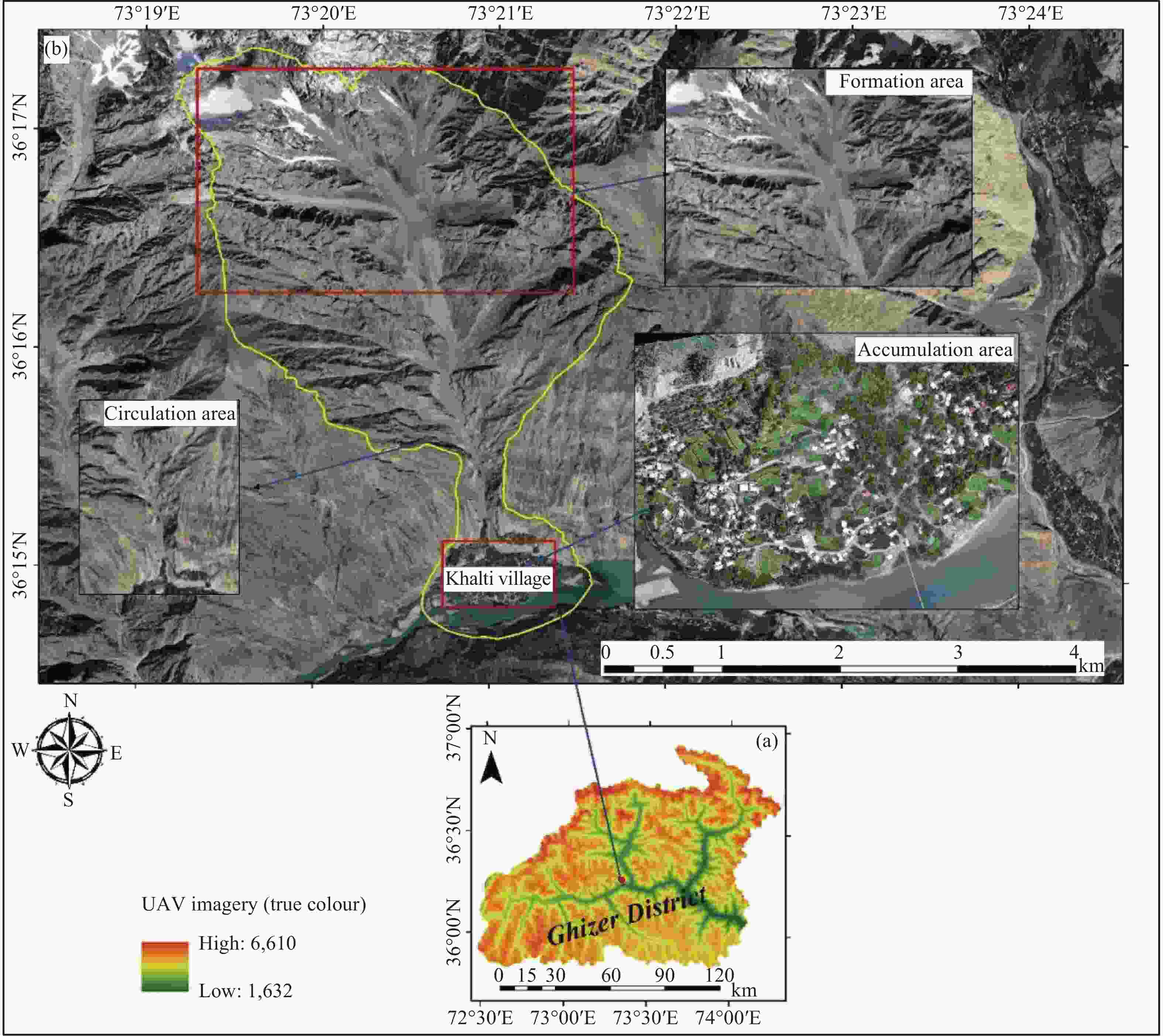
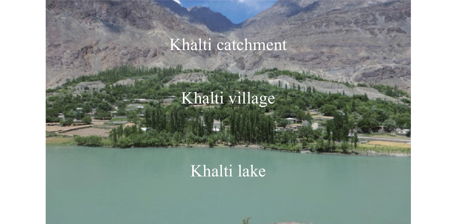
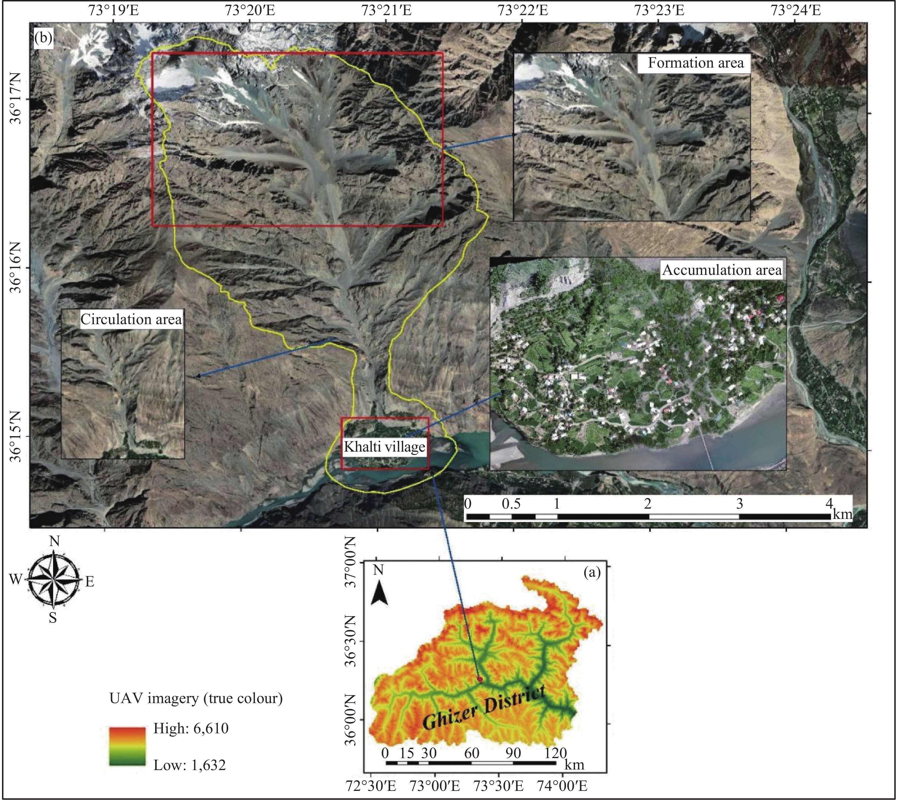
Figure 1. Location map of the selected watershed (Khalti Village) for the debris flow modelling
Notes: (a) Elevation of the district, (b) Khalti catchment with streams, and the inset shows a zoomed-in view of UAV imagery of the fan
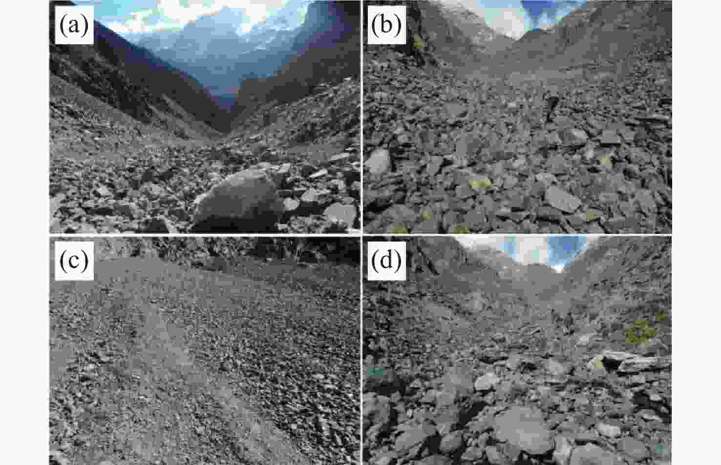
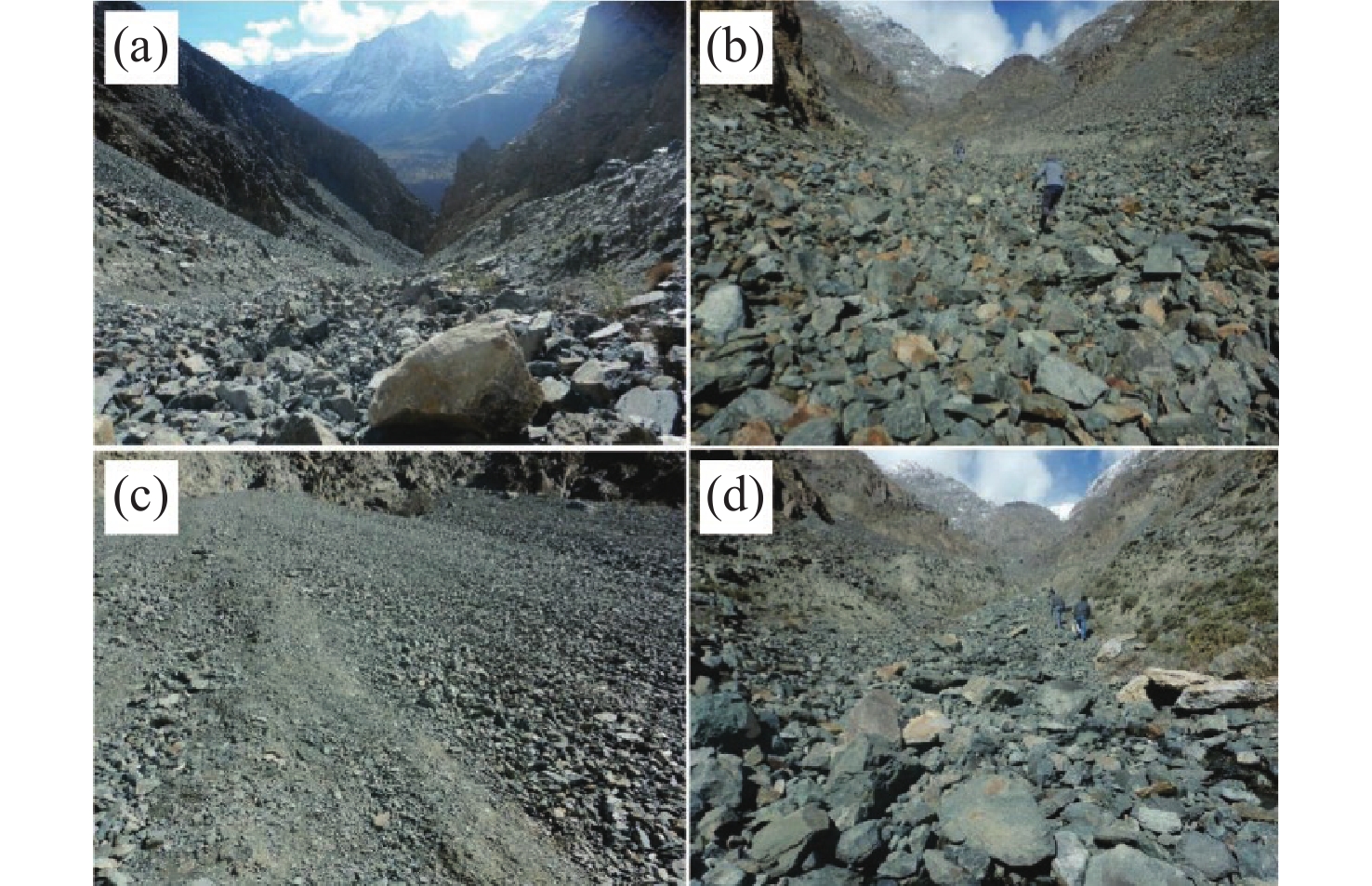
Figure 3. Field photographs showing the nature of the material and erosion in the catchment
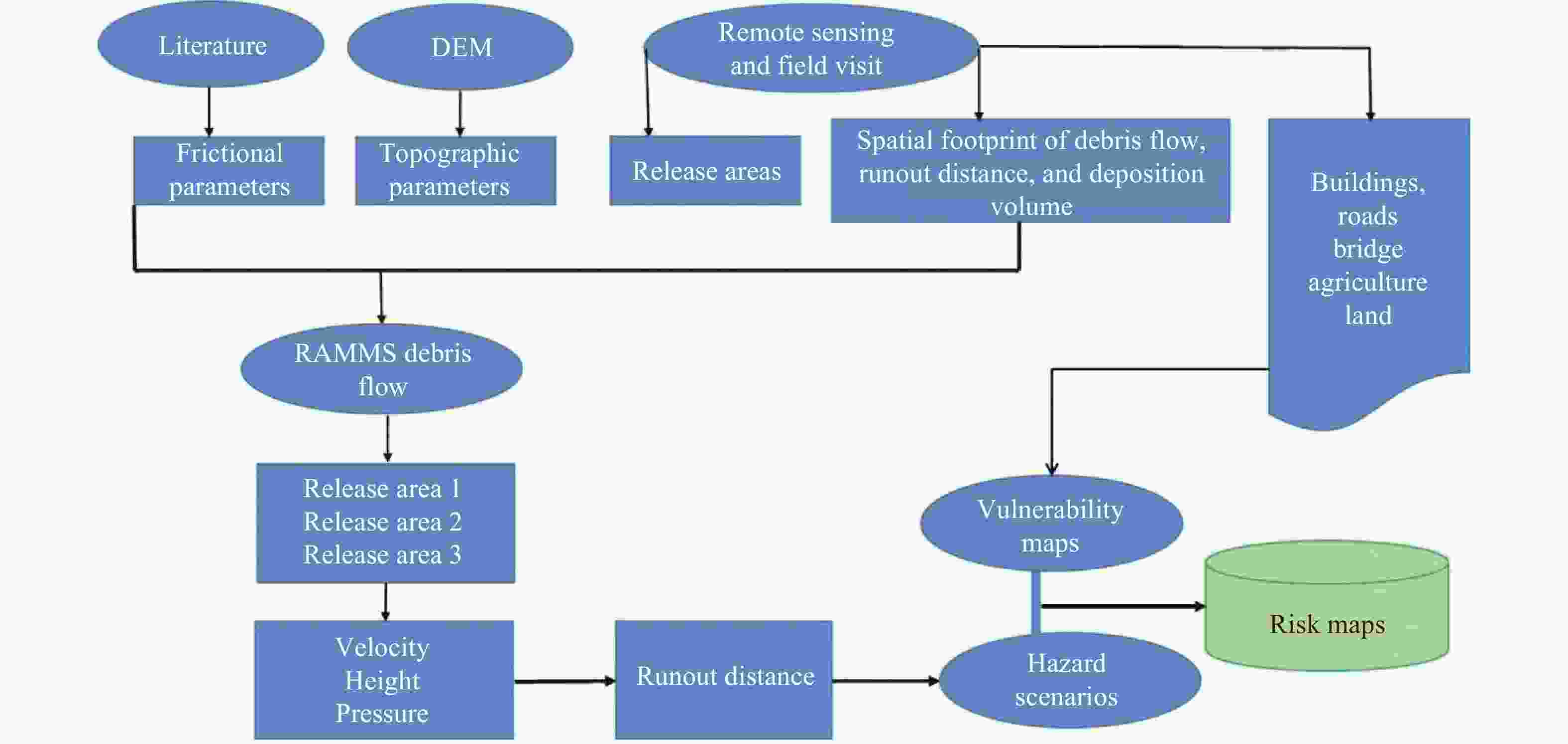
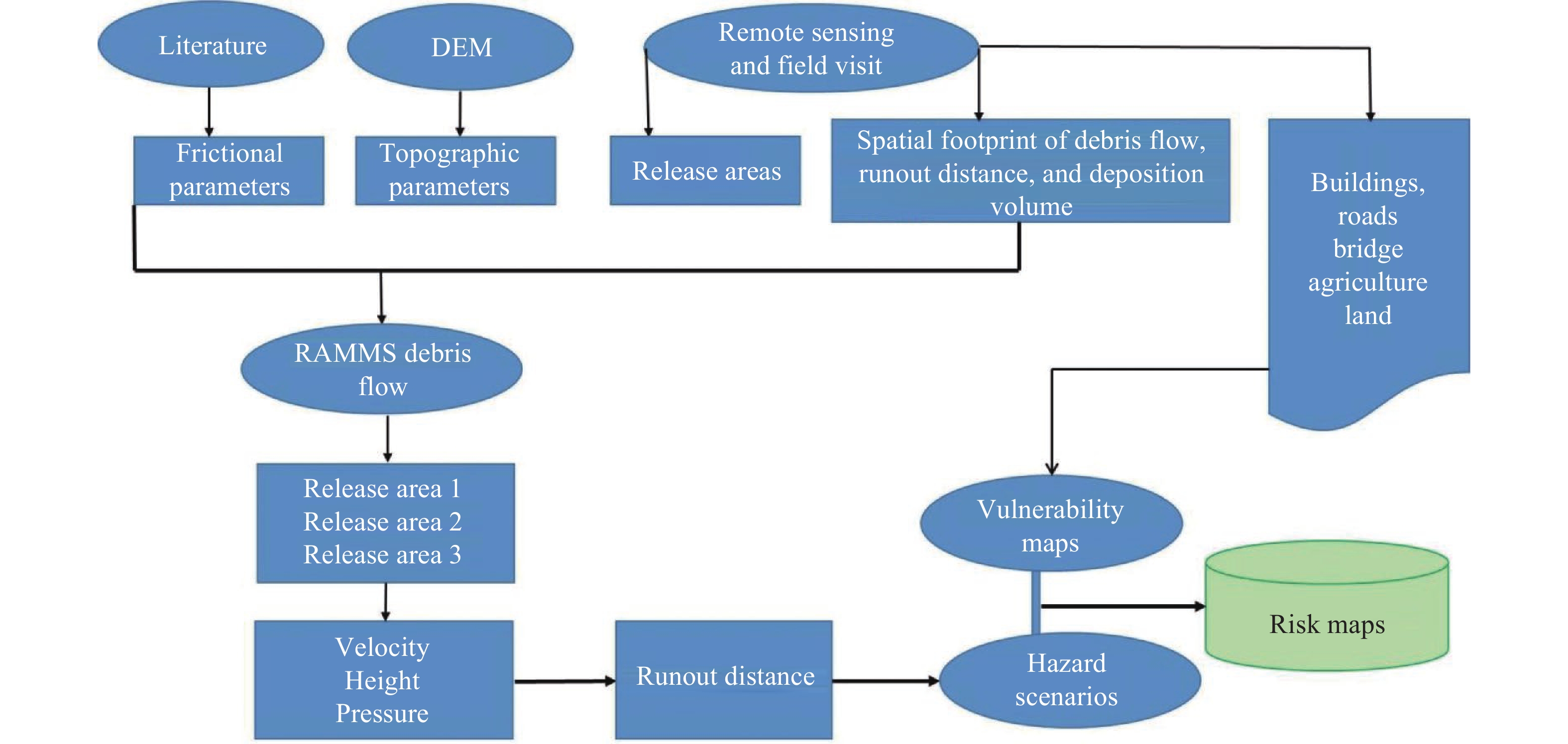
Figure 4. Flowchart of the methods for the hazard scenarios, vulnerability and risk assessments of all scenarios for debris flow
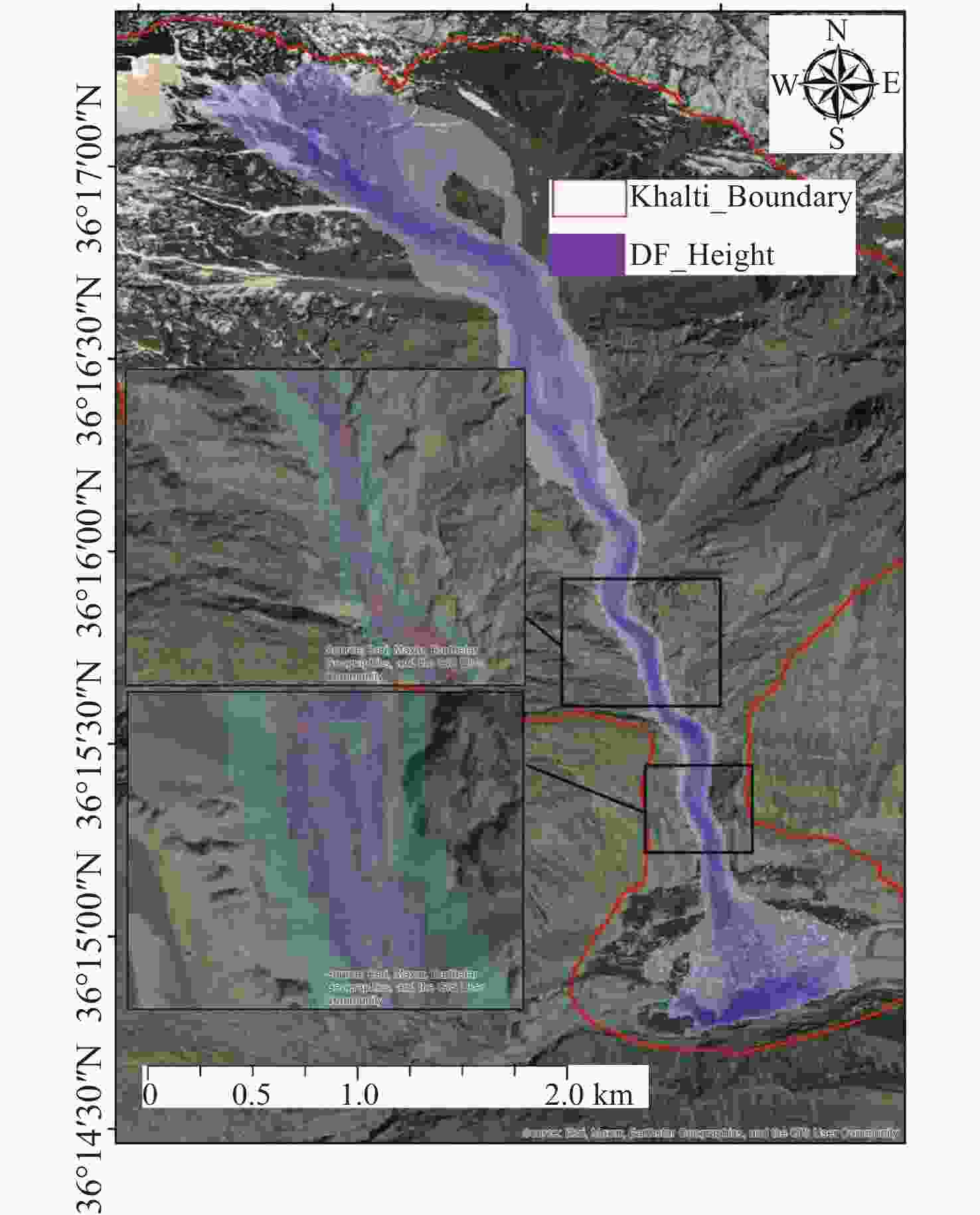
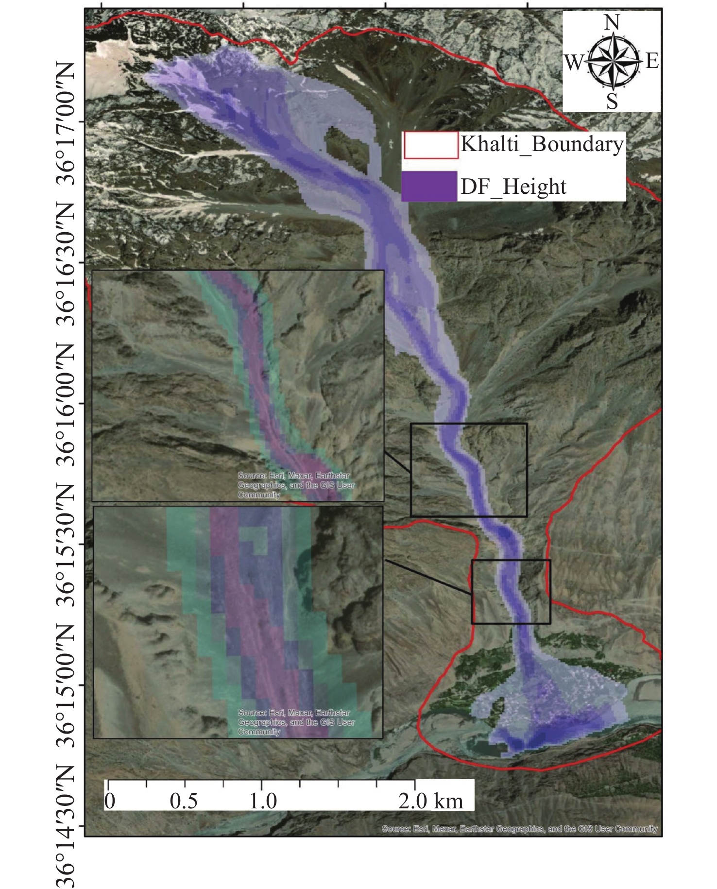
Figure 5. Simulated debris flow height using RAMMS-DF for the calibrated values (μ = 0.07, and ξ = 550 m/s2), showing the simulation
Notes: The purple gradient represents the modeled debris flow height (DF_Height) along the flow path. The insets highlight key deposition zones for calibration and validation.
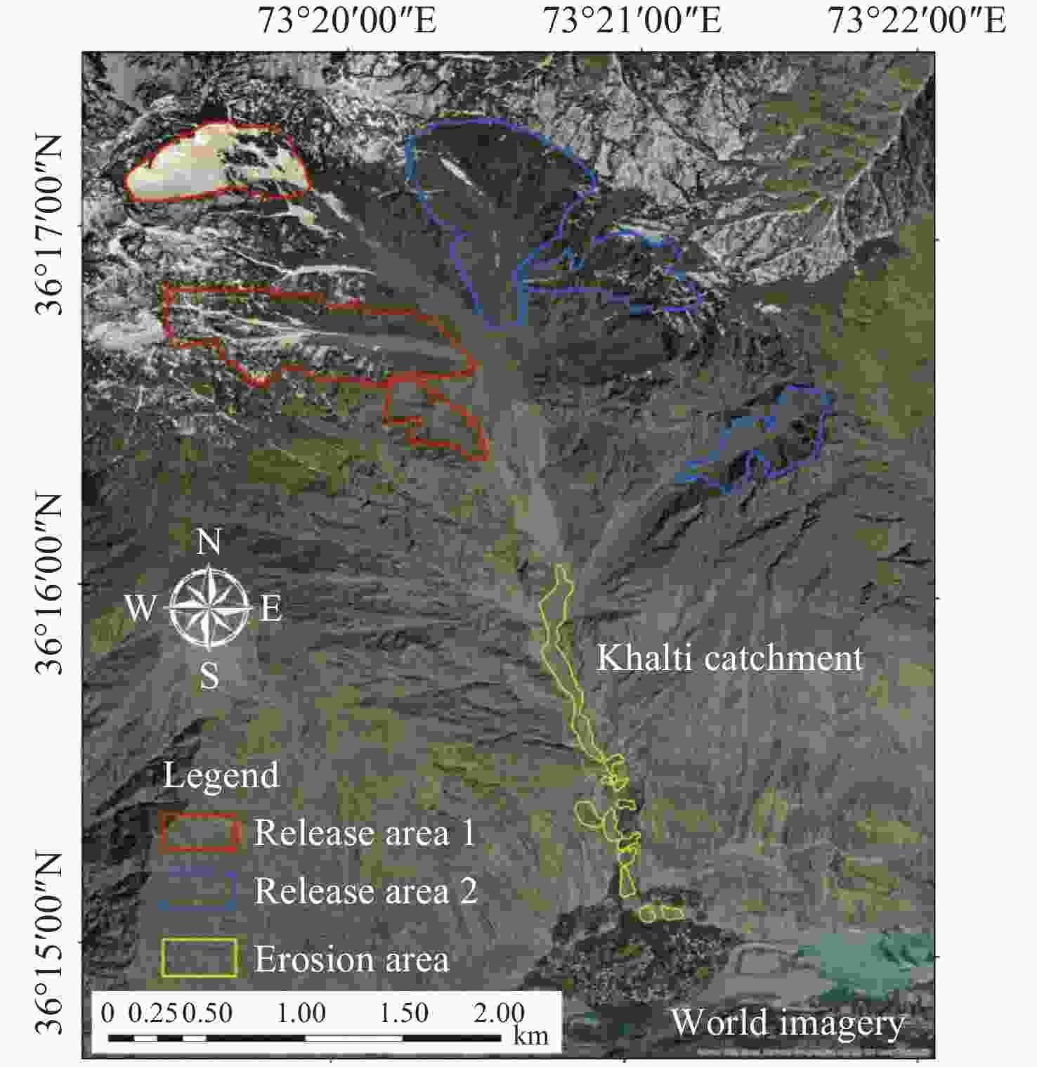
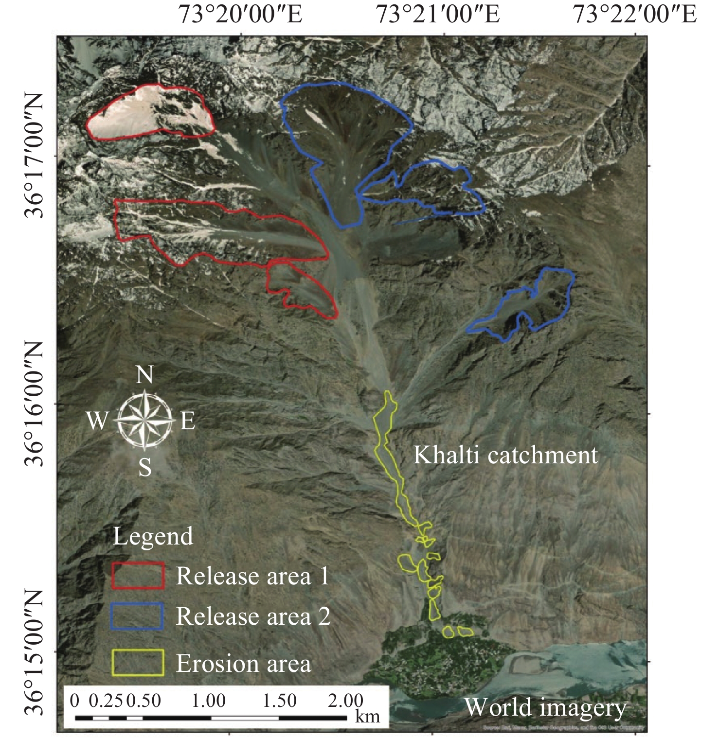
Figure 6. Release areas and erosion material for debris flow
Notes: Red colored polygons indicate release area 1, blue colored polygons indicate release area 2, and yellow-colored polygons show the erosion area.
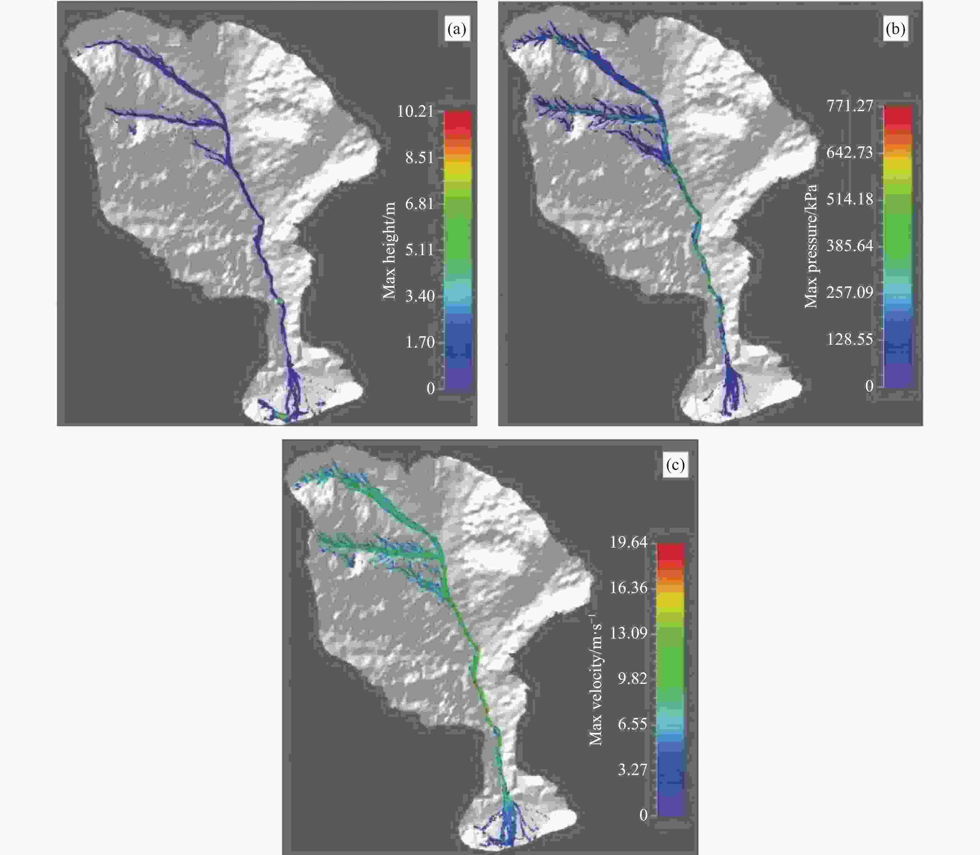
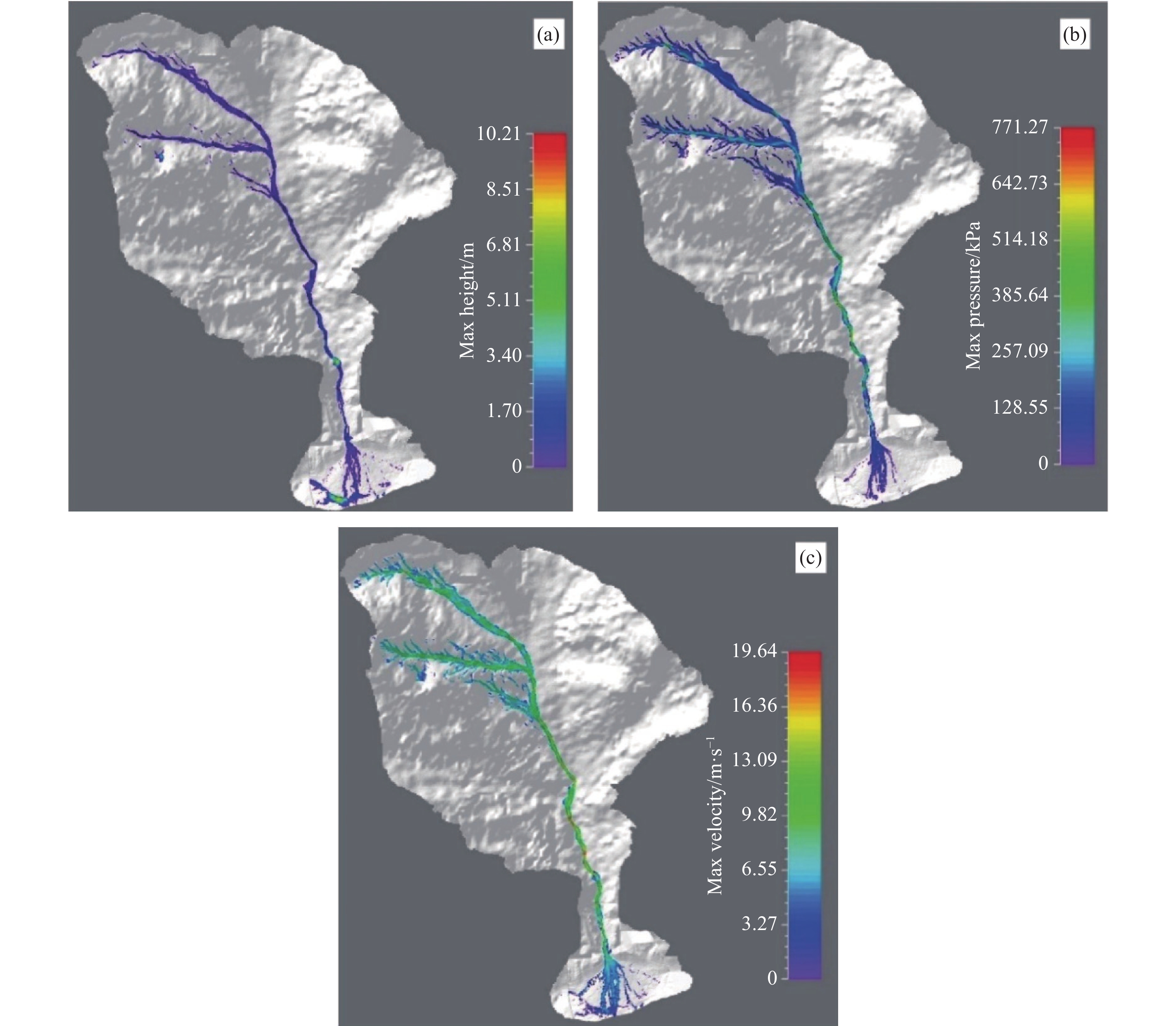
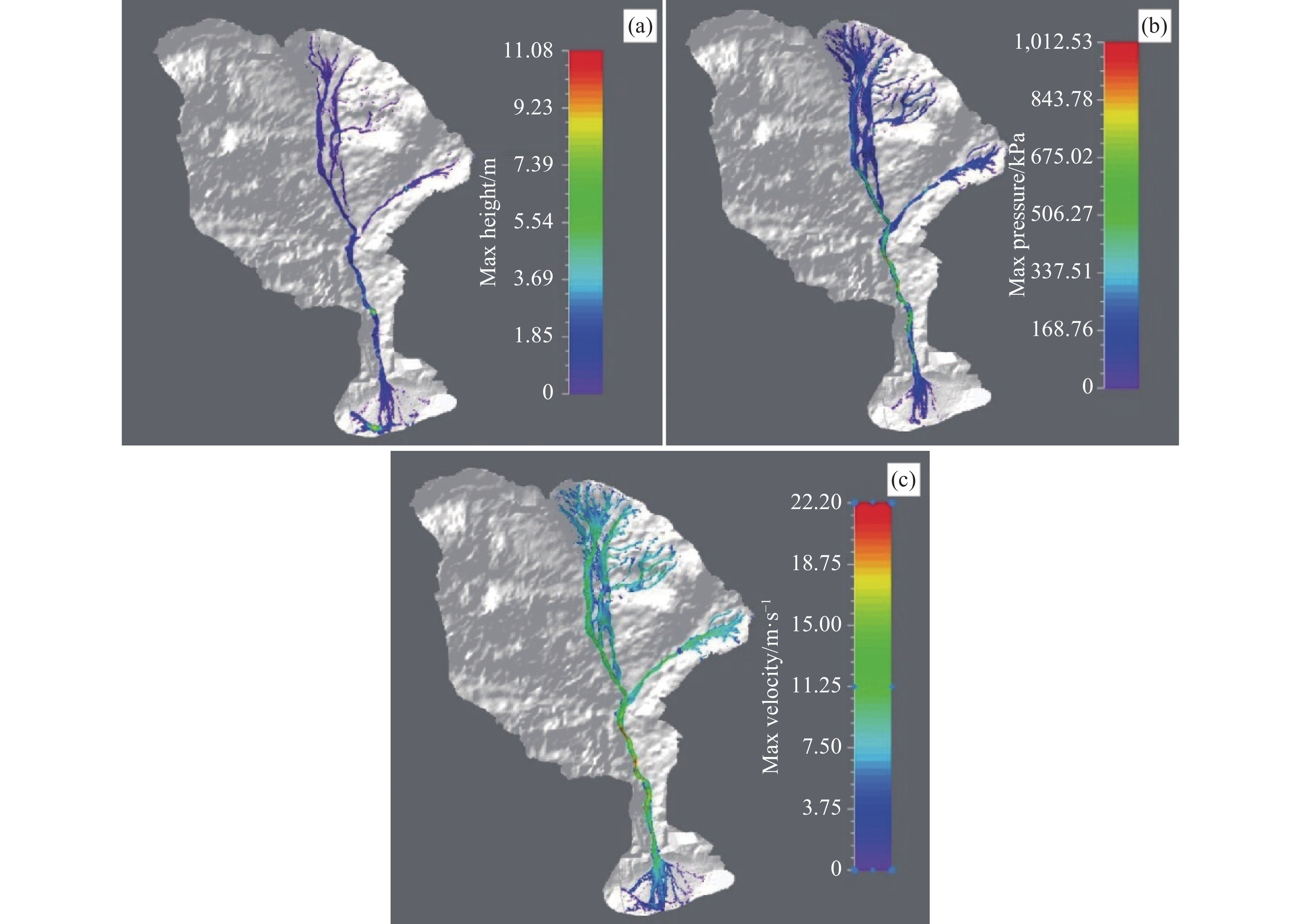
Figure 7. Simulation output from the source zone to the depositional zone for Scenario 1: (a) height, (b) pressure, and c) velocity
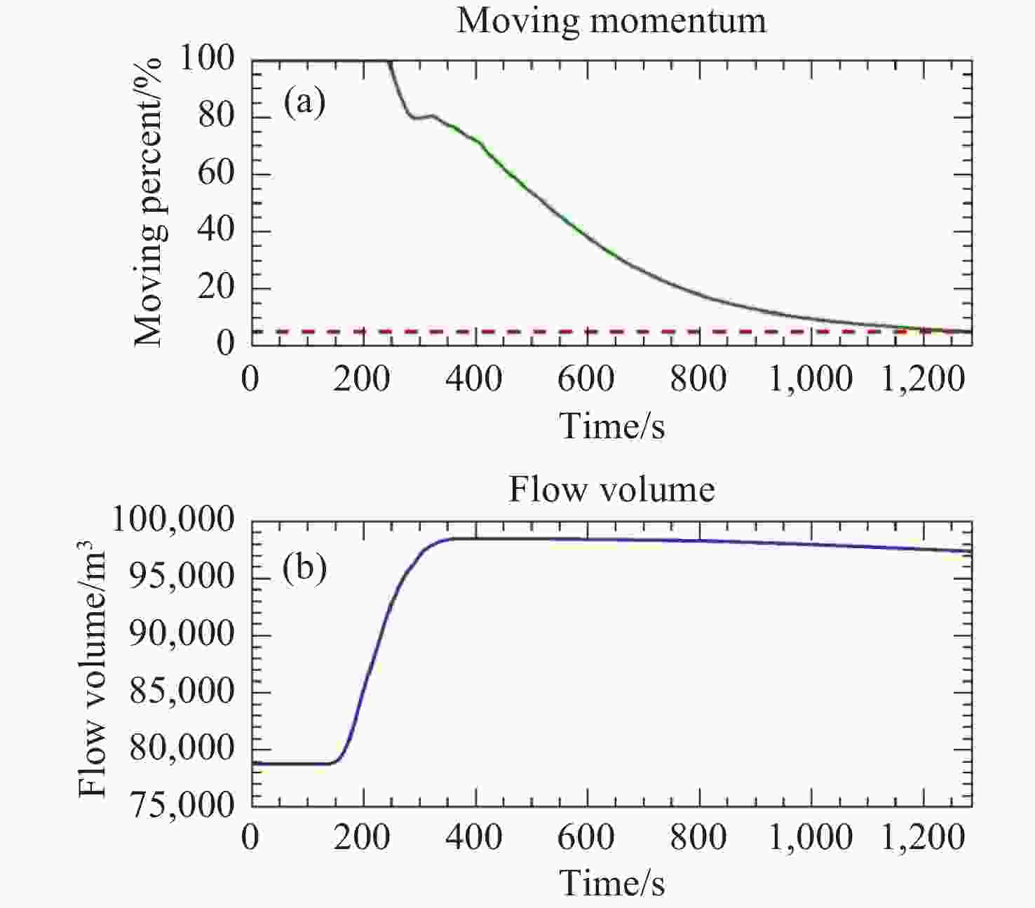
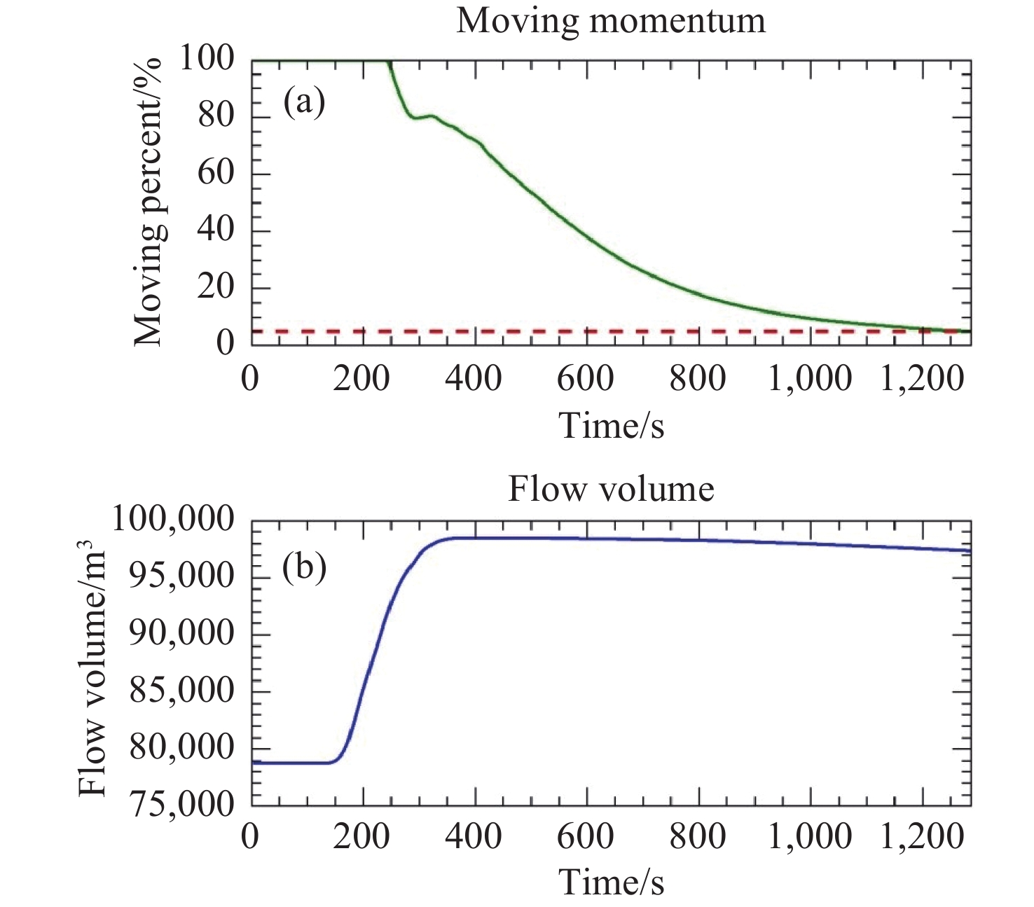
Figure 8. Debris flow dynamics over time for Scenario 1
Notes: (a) Shows the moving percent (green line, left Y-axis), which indicates the percentage of total debris mass in motion, and moving momentum (red dashed line), which reflects the energy of the moving flow. (b) Shows the flow volume (blue line, Y-axis). The x-axis in both figures represents time
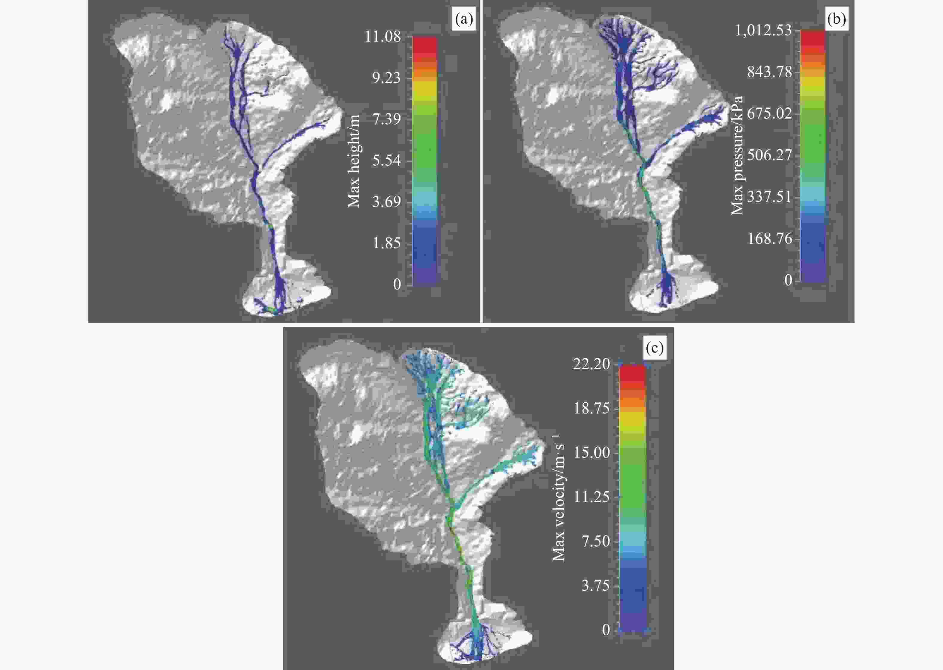
Figure 9. Simulation output from the source zone to the depositional zone for Scenario 2: (a) height, (b) pressure, and (c) velocity
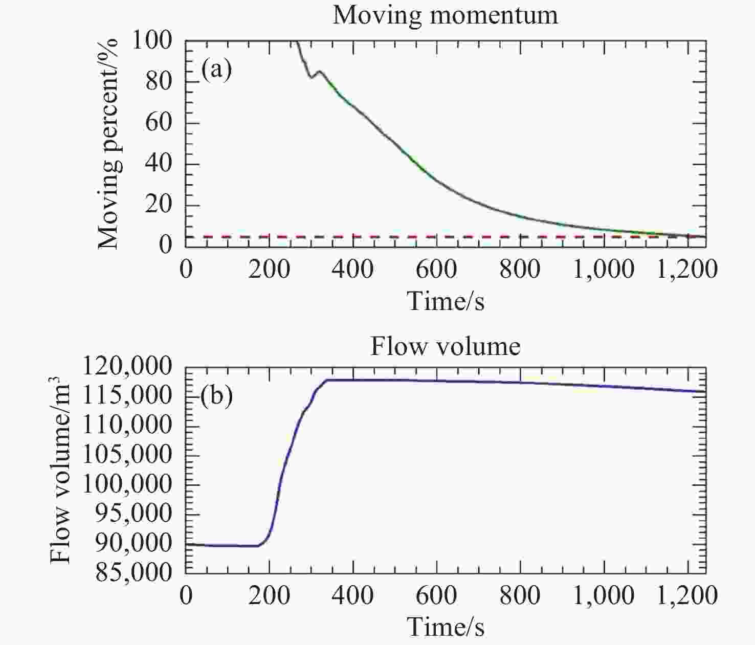
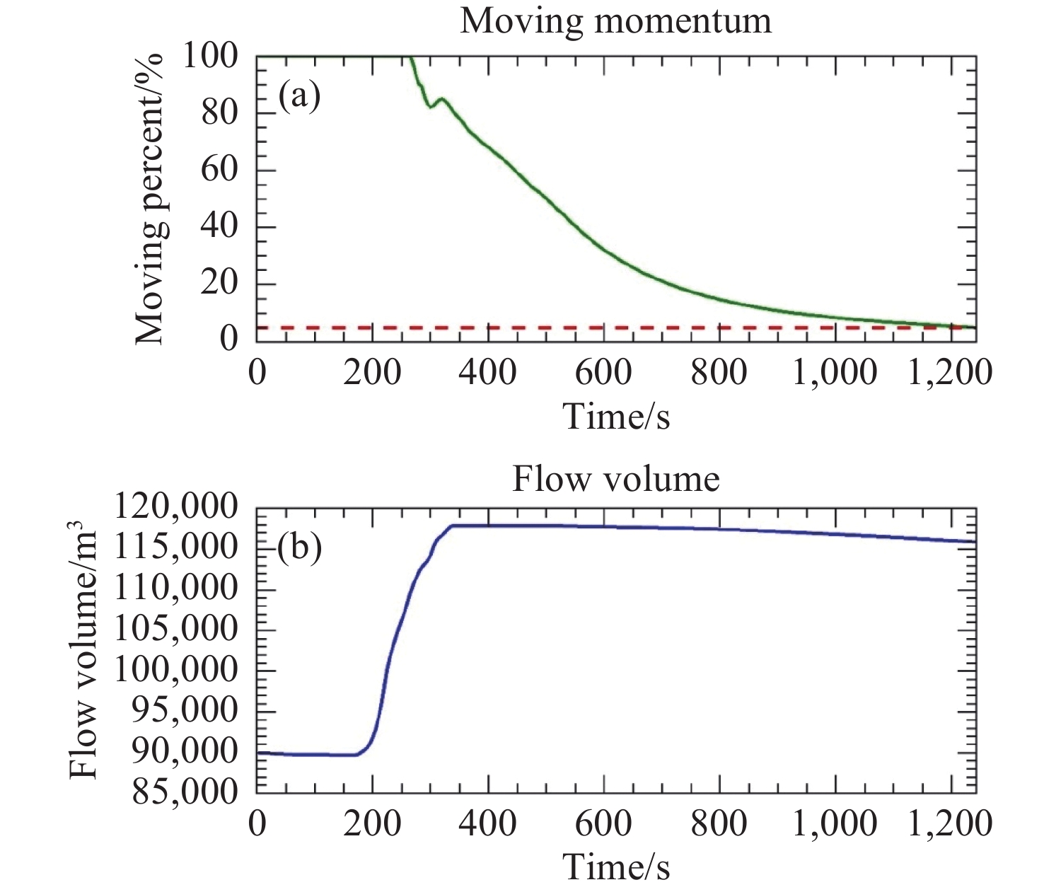
Figure 10. Debris flow dynamics over time for Scenario 2
Notes: (a) Shows the moving percent (green line, left Y-axis), which indicates the percentage of total debris mass in motion, and moving momentum (red dashed line), which reflects the energy of the moving flow. (b) Shows the flow volume (blue line, y-axis). The x-axis in both figures represents time
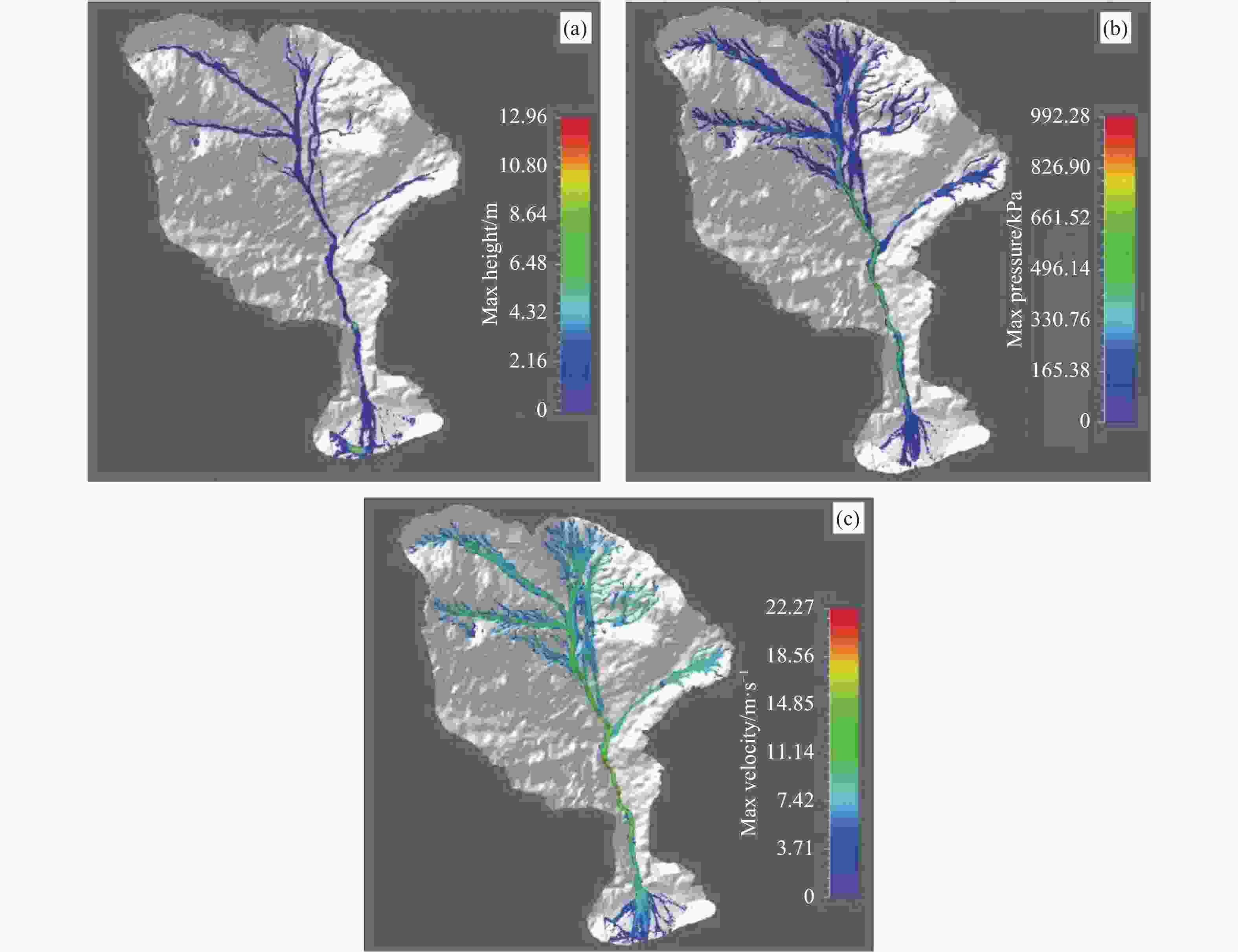
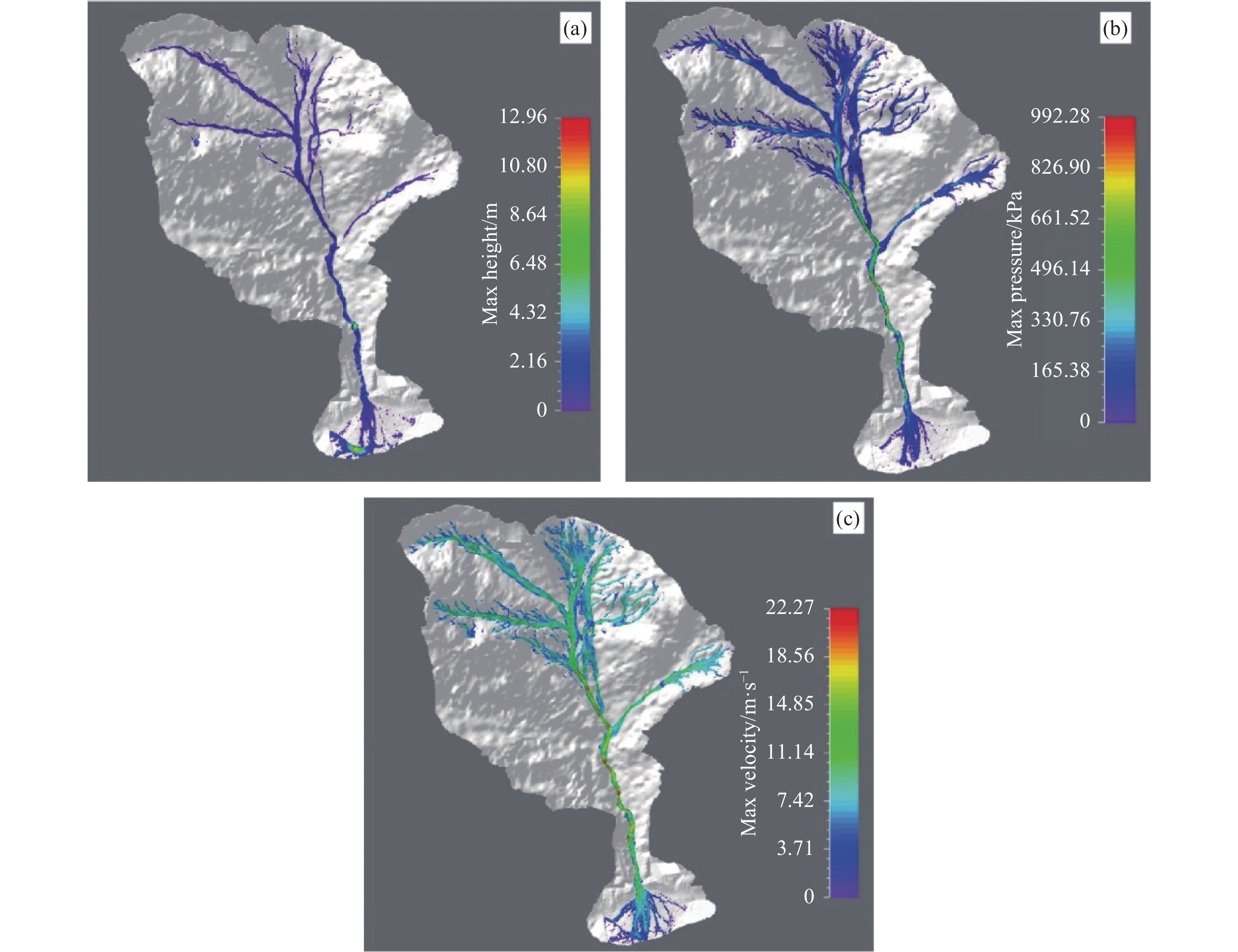
Figure 11. Simulation output from the source zone to the depositional zone for Scenario 3: a) height, b) pressure, and c) velocity
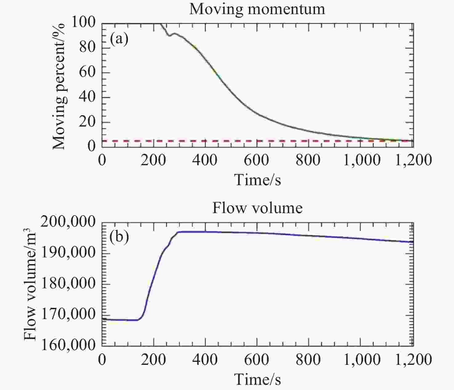
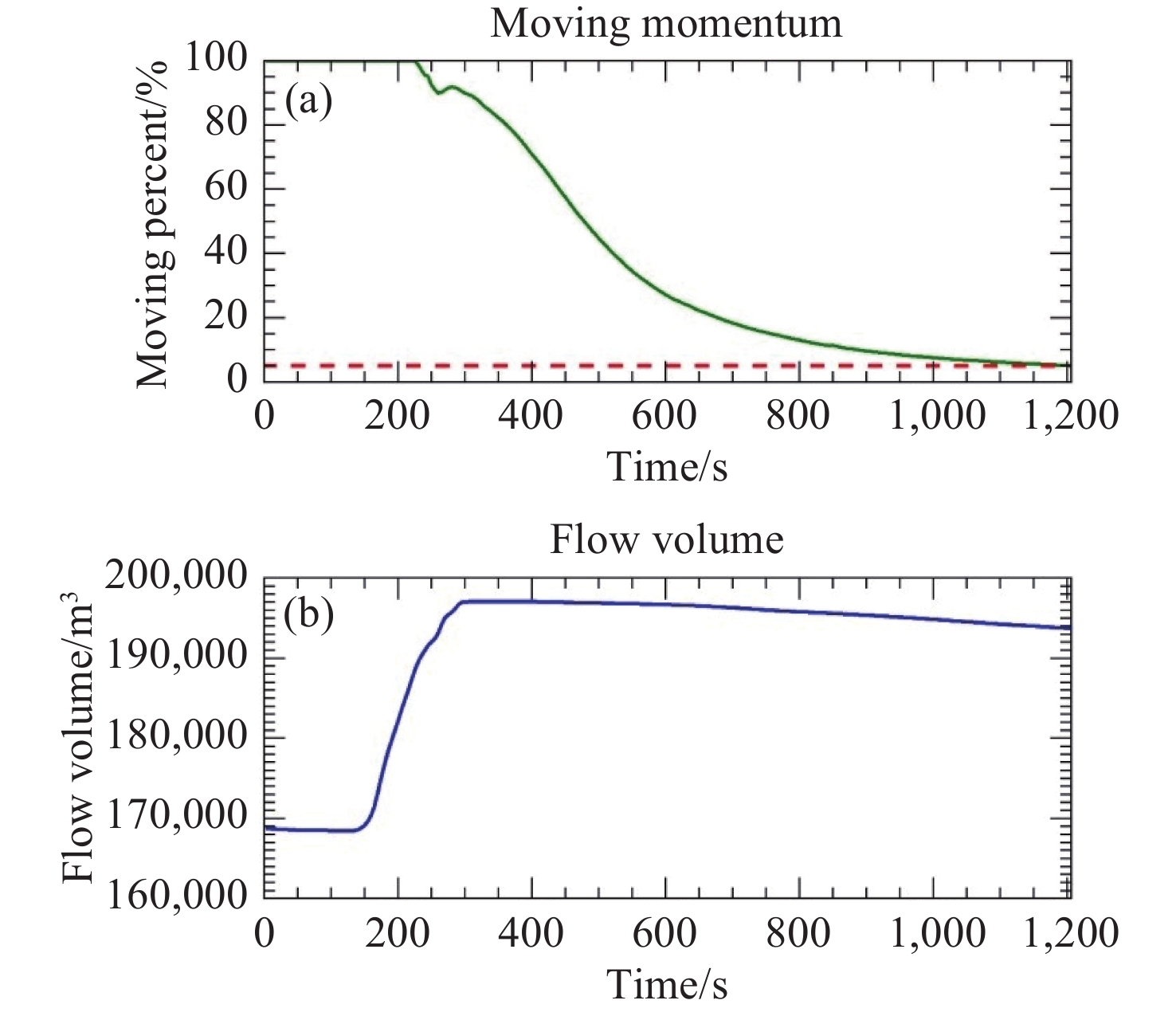
Figure 12. Debris flow dynamics over time for Scenario 3
Notes: (a) Shows the moving percent (green line, left y-axis), which indicates the percentage of total debris mass in motion, and moving momentum (red dashed line), which reflects the energy of the moving flow. (b) Shows the flow volume (blue line, y-axis). The x-axis in both figures represents time
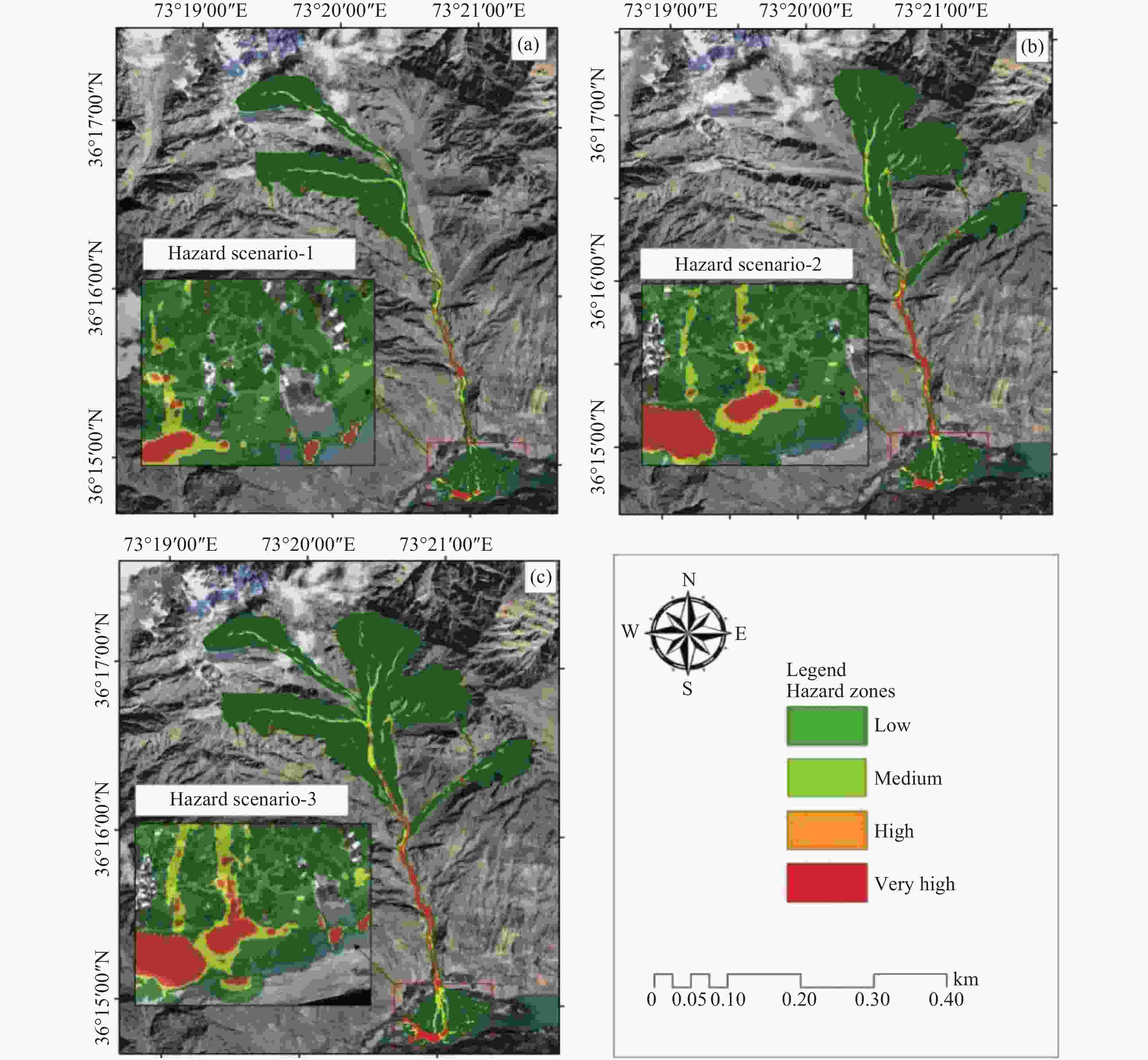
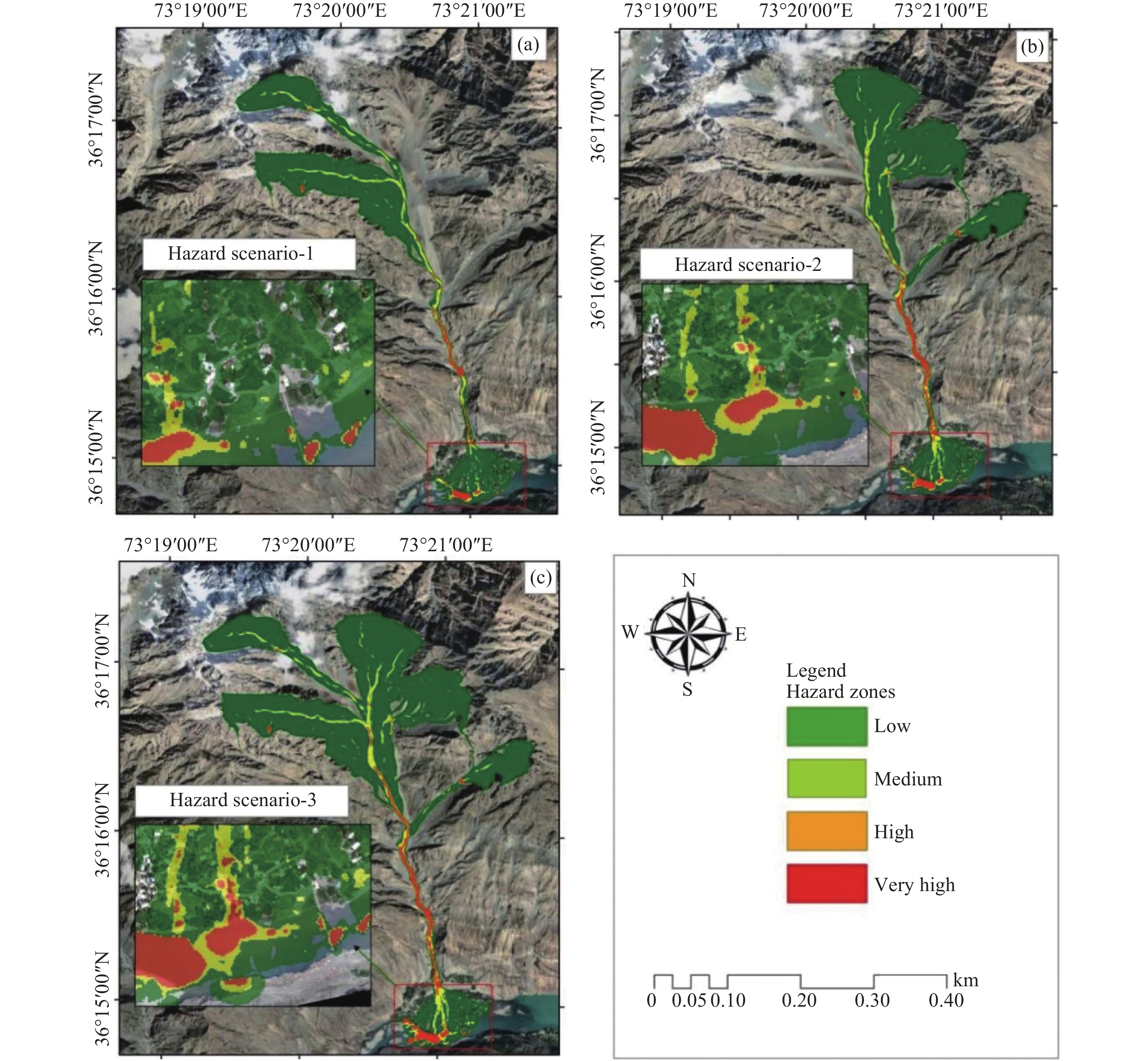
Figure 13. Hazard maps of debris flow for all three scenarios based on height: (a) Scenario 1. (b) Scenario 2. (c) Scenario 3. The insets show zoomed-in views of low to very high hazard classes for each scenario
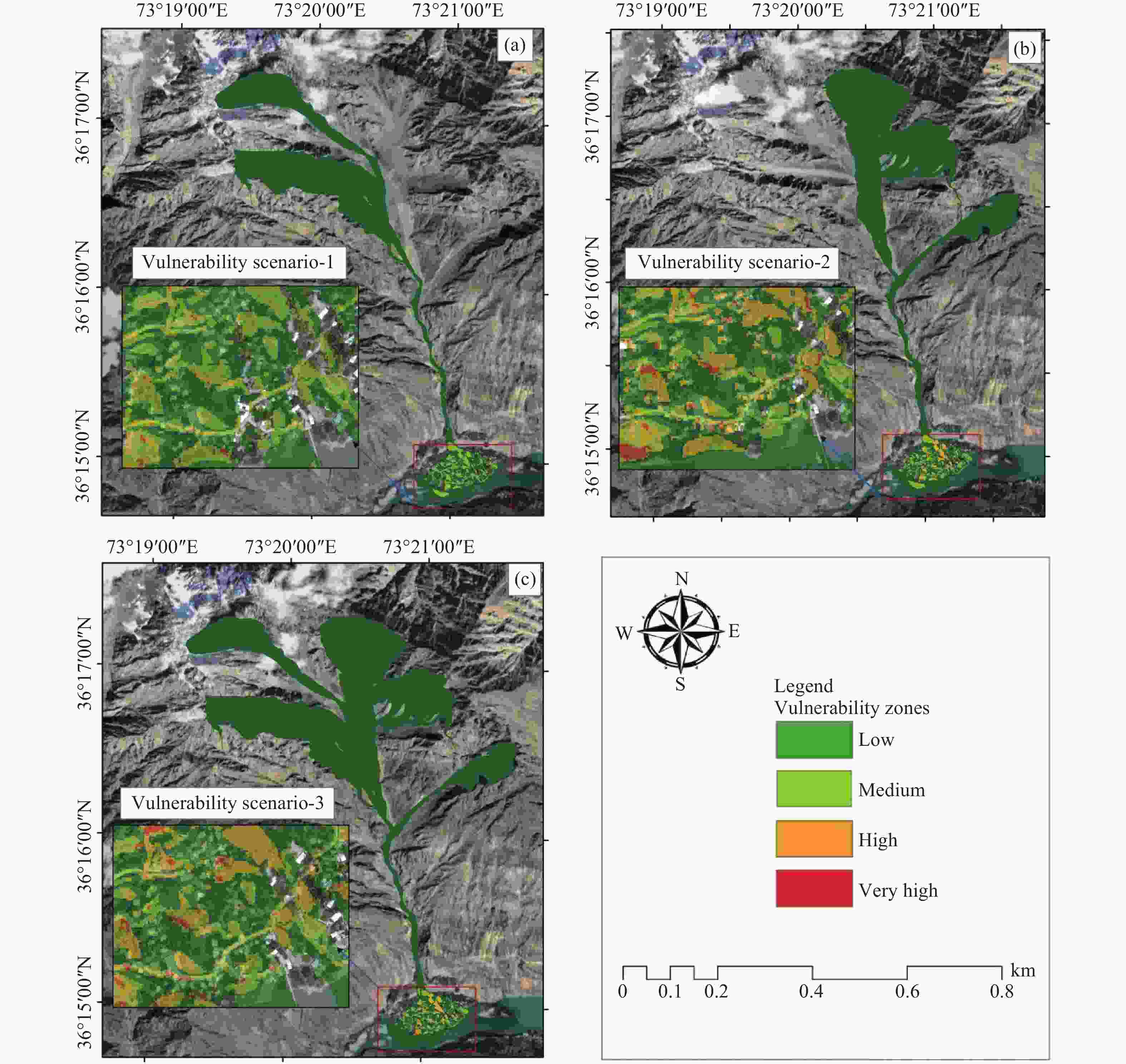
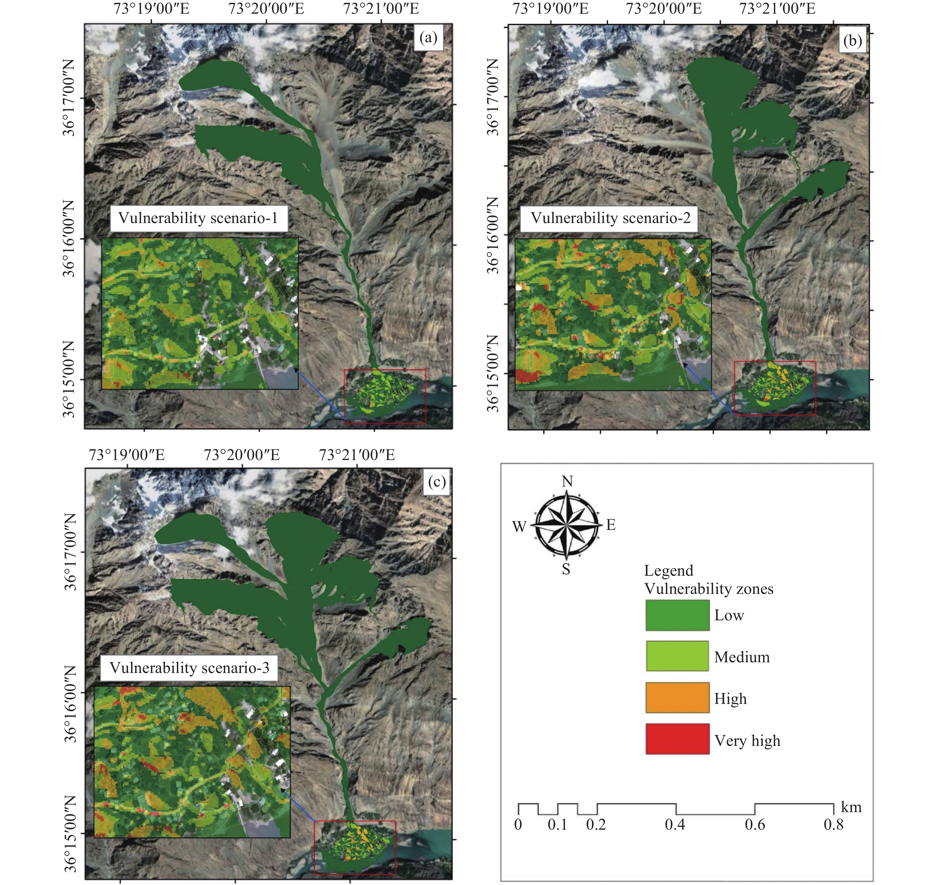
Figure 14. Debris flow vulnerability maps for all three scenarios. (a) Scenario 1; (b) Scenario 2; (c) Scenario 3. The insets show zoomed-in views of low to very highly vulnerable zones for each class

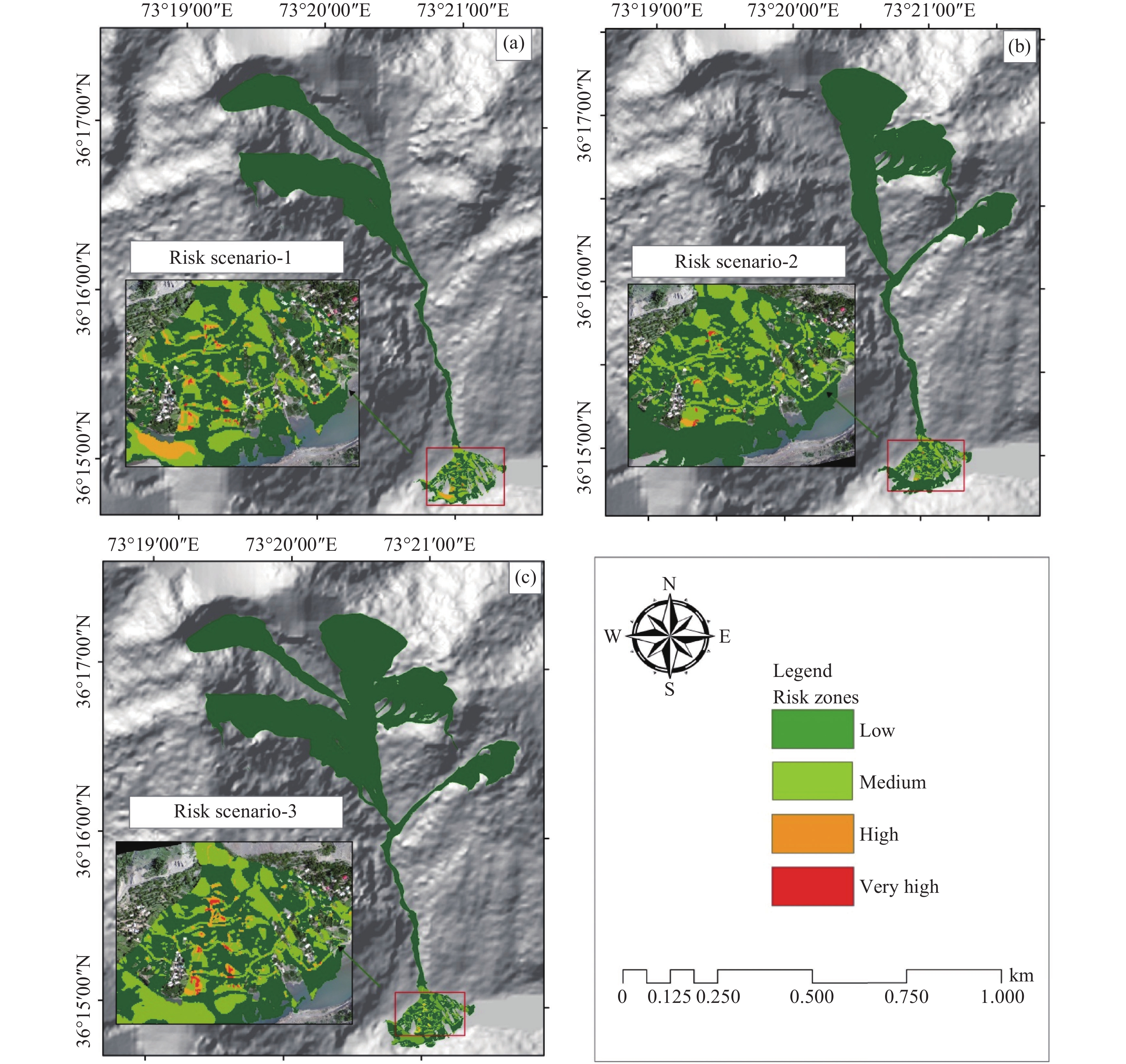
Figure 15. Debris flow risk maps for all three scenarios: (a) Scenario 1, (b) Scenario 2, (c) Scenario 3, the insets show zoomed-in views of the risk maps
Table 1. Parameters for RAMMS-DF software in scenario-based analysis following (Gardezi et al. 2021)
Analysis Friction
Coefficient, µTurbulent coefficient, ξ (m/s2) DEM (m) Scenario-1 0.07 550 2 Scenario-2 0.07 550 2 Scenario-3 0.07 550 2  下载: 导出CSV
Table 2. Values used for hazard assessment zoning following (Tang et al. 1993)
S. No Debris flow hazard zoning Flow velocity (m/s) Flow height
(m)01. Extremely high-hazard area > 5 > 3 02. High hazard area 2–5 1–3 03. Medium hazard area 1–2 0.5–1 04. Low hazard area < 1 < 0.5
下载: 导出CSV
Table 3. Shows assigned weights to elements at risk for vulnerability assessment based on AHP
Element at risk Assigned weights Buildings 0.40 Roads 0.25 Agriculture land 0.15 Orchards 0.06 Bridge 0.10 Lake 0.04
下载: 导出CSV
Table 4. Summary of simulation output values
Scenario Max Flow Height (m) Peak Impact Pressure (kPa) Max Velocity (m/s) Scenario 1 10.21 771.27 19.64 Scenario 2 11.08 1012.53 22.50 Scenario 3 12.96 992.28 22.27
下载: 导出CSV
Table 5. Spatial distribution of vulnerability zones for each scenario
Scenario Low vulnerability/m2 Moderate vulnerability/m2 High vulnerability/m2 Very high vulnerability/m2 Scenario 1 1,377,100 71,739 6,498 486 Scenario 2 1,702,140 51,021 37,152 3,141 Scenario 3 2,818,670 42,255 32,499 3,951
下载: 导出CSV
Table 6. Shows the number of houses and persons in risk classes for all three scenarios
Scenarios Low risk Medium risk High risk Very high risk Houses Person Houses Person Houses Person Houses Person 1 165 1378 21 166 9 72 3 24 2 149 1192 32 248 12 96 5 40 3 134 1072 40 320 16 128 8 64
下载: 导出CSV
-
Abraham MT, Satyam N, Reddy SKP, et al. 2021. Runout modeling and calibration of friction parameters of Kurichermala debris flow, India. Landslides, 18: 737−754. DOI: 10.1007/s10346-020-01540-1. Ahmad N, Shafique M, Hussain ML, et al. 2025. Integrated debris flow hazard and risk assessment using UAV data and RAMMS, a case study in northern Pakistan. Natural Hazards, 121(2): 1463−1487. DOI: 10.1007/s11069-024-06862-0. Ahmad T, Jan MQ, Drüppel K. 2025. Geology of the central Kohistan Arc, Northern Swat, Kalam (NW, Pakistan), results of a new 1: 50, 000 scale geological mapping. Journal of Maps, 21(1): 2572765. DOI: 10.1080/17445647.2025.2572765. Ahmed M, Titti G, Trevisani S, et al. 2025. Is higher resolution always better? A comparison of open-access DEMs for optimized slope unit delineation and regional landslide prediction. Natural Hazards and Earth System Sciences, 25(7): 2519−2539. DOI: 10.5194/nhess-25-2519-2025. Alcántara-Ayala I, Sassa K. 2023. Landslide risk management: From hazard to disaster risk reduction. Landslides, 20(10): 2031−2037. DOI: 10.1007/s10346-023-02140-5. Ali S, Haider R, Abbas W, et al. 2021. Empirical assessment of rockfall and debris flow risk along the Karakoram Highway, Pakistan. Natural Hazards, 106: 2437−2460. DOI: 10.1007/s11069-021-04549-4. Bartelt P, Bühler Y, Christen M, et al. 2015. RAMMS-DF User Manual. WSL Institute for Snow and Avalanche Research SLF, Davos, Birmensdorf, Switzerland. Available on http://ramms.slf.ch/ramms/, last access, 28. Bezak N, Sodnik J, Mikoš M. 2019. Impact of a random sequence of debris flows on torrential fan formation. Geosciences, 9(2): 64. DOI: 10.3390/geosciences9020064. Cabral V, Reis F, Veloso V, et al. 2023. A multi-step hazard assessment for debris-flow prone areas influenced by hydroclimatic events. Engineering Geology, 313: 106961. DOI: 10.1016/j.enggeo.2022.106961. Cai S, Zhang Z, Yang X, et al. 2025. The modified theoretical model for debris flows predication with multiple rainfall characteristic parameters. Scientific Reports, 15(1): 12402. DOI: 10.1038/s41598-024-84199-1. Cao C, Xu P, Chen J, et al. 2017. Hazard assessment of debris-flow along the baicha river in Heshigten Banner, Inner Mongolia, China. International Journal of Environmental Research and Public Health, 14(1): 30. DOI: 10.3390/ijerph14010030. Chen M, Tang C, Xiong J, et al. 2024. Spatio-temporal mapping and long-term evolution of debris flow activity after a high magnitude earthquake. Catena, 236: 107716. DOI: 10.1016/j.catena.2023.107716. Chen TL, Wu YH, Chiu YH. 2025. Debris flow risk characteristics and potential spatial mitigation strategies under extreme rainfall events. Climate Services, 40: 100618. DOI: 10.1016/j.cliser.2025.100618. Christen M, Kowalski J, Bartelt P. 2010. RAMMS: Numerical simulation of dense snow avalanches in three-dimensional terrain. Cold Regions Science and Technology, 63(1): 1−14. DOI: 10.1016/j.coldregions.2010.04.005. Dash RK, Kanungo DP, Malet JP. 2021. Runout modelling and hazard assessment of Tangni debris flow in Garhwal Himalayas, India. Environmental Earth Sciences, 80: 1−19. DOI: 10.1007/s12665-021-09637-z. Eckert N, Corona C, Giacona F, et al. 2024. Climate change impacts on snow avalanche activity and related risks. Nature Reviews Earth and Environment, 5(5): 369−389. DOI: 10.1038/s43017-024-00540-2. Fan J, Galoie M. 2025. Assessment of physical parameters impacts on debris flow modeling with RAMMS. Scientific Reports, 15(1): 36393. DOI: 10.1038/s41598-025-20303-3. Gan J, Zhang YS. 2019. Numerical simulation of debris flow runout using Ramms: A case study of Luzhuang Gully in China. Computer Modeling in Engineering and Sciences, 981−1009. DOI: 10.32604/cmes.2019.07337. Gardezi H, Bilal M, Cheng Q, et al. 2021. A comparative analysis of attabad landslide on january 4, 2010, using two numerical models. Natural Hazards, 107: 519−538. DOI: 10.1007/s11069-021-04593-0. Gu Z, Yao X, Zhu X. 2025. Debris flow susceptibility in the Jinsha River Basin, China: a Bayesian assessment framework based on geomorphodynamic parameters. Natural Hazards and Earth System Sciences, 25(10): 3957−3975. DOI: 10.5194/nhess-25-3957-2025. Holub M, Suda J, Fuchs S. 2012. Mountain hazards: reducing vulnerability by adapted building design. Environmental Earth Sciences, 66: 1853−1870. DOI: 10.1007/s12665-011-1410-4. Hou S, Cao P, Li A, et al. 2021. In Debris flow hazard assessment of the Eryang River watershed based on numerical simulation. IOP Conference Series: Earth and Environmental Science. IOP Publishing: 062002. DOI: 10.1088/1755-1315/861/6/062002. Hussin H, Quan Luna B, Van Westen C, et al. 2012. Parameterization of a numerical 2-D debris flow model with entrainment: A case study of the Faucon catchment, Southern French Alps. Natural Hazards and Earth System Sciences, 12(10): 3075−3090. DOI: 10.5194/nhess-12-3075-2012. Islam MA, Chattoraj SL. 2023. Modelling landslides in the Lesser Himalaya region using geospatial and numerical simulation techniques. Arabian Journal of Geosciences, 16(8): 480. DOI: 10.1007/s12517-023-11541-8. Khan MA, Haneef M, Khan AS, et al. 2013. Debris-flow hazards on tributary junction fans, Chitral, Hindu Kush Range, northern Pakistan. Journal of Asian Earth Sciences, 62: 720−733. DOI: 10.1016/j.jseaes.2012.11.025. Khan MA, Mustaffa Z, Harahap ISH, et al. 2022. Assessment of physical vulnerability and uncertainties for debris flow hazard: A review concerning climate change. Land, 11(12): 2240. DOI: 10.3390/land11122240. Khan MU, Tian S, Chen N, et al. 2025. Understanding the formation mechanism of rainfall and snowmelt jointly induced Bicharh Nallah debris flow, North Pakistan. Environmental Earth Sciences, 84(3): 86. DOI: 10.1007/s12665-024-12054-7. Knight J. 2022. Scientists' warning of the impacts of climate change on mountains. PeerJ, 10: e14253. DOI: 10.7717/peerj.14253. Krishnapriya V, Rajaneesh A, Sajinkumar K, et al. 2024. A rapid run-out assessment methodology for the 2024 Wayanad debris flow. Npj Natural Hazards, 1(1): 41. DOI: 10.1038/s44304-024-00044-5. Li L, Lin H, Qiang Y, et al. 2024. A combination weighting method for debris flow risk assessment based on t-distribution and linear programming optimization algorithm. Plos one, 19(6): e0303698. DOI: 10.1371/journal.pone.0303698. Li Y, Zou Q, Hao J, et al. 2023. Risk assessment of debris flows along the Karakoram Highway (Kashgar-Khunjerab Section) in the context of climate change. International Journal of Disaster Risk Science, 14(4): 586−599. DOI: 10.1007/s13753-023-00501-1. Martini M, Baggio T, D'Agostino V. 2023. Comparison of two 2-D numerical models for snow avalanche simulation. Science of The Total Environment, 896: 165221. DOI: 10.1016/j.scitotenv.2023.165221. Melo R, van Asch T, Zêzere JL. 2018. Debris flow run-out simulation and analysis using a dynamic model. Natural Hazards and Earth System Sciences, 18(2): 555−570. DOI: 10.5194/nhess-18-555-2018. Mikoš M, Bezak N. 2021. Debris flow modelling using RAMMS model in the Alpine environment with focus on the model parameters and main characteristics. Frontiers in Earth Science, 8: 605061. DOI: 10.3389/feart.2020.605061. Ouyang C, Wang Z, An H, et al. 2019. An example of a hazard and risk assessment for debris flows—A case study of Niwan Gully, Wudu, China. Engineering Geology, 263: 105351. DOI: 10.1016/j.enggeo.2019.105351. Qiao Z, Li T, Simoni A, et al. 2023. Numerical modelling of an alpine debris flow by considering bed entrainment. Frontiers in Earth Science, 10: 1059525. DOI: 10.3389/feart.2022.1059525. Qing F, Zhao Y, Meng X, et al. 2020. Application of machine learning to debris flow susceptibility mapping along the China–Pakistan Karakoram Highway. Remote Sensing, 12(18): 2933. DOI: 10.3390/rs12182933. Qodri MF, Noviardi N, Mase LZ. 2021. Numerical modelling based on Digital Elevation Model (DEM) analysis of debris flow at Rinjani Volcano, West Nusa Tenggara, Indonesia. Journal of the Civil Engineering Forum, 7(3): 279−288. Petra Christian University. DOI: 10.22146/jcef.63417. Rajaneesh A, Krishnapriya V, Sajinkumar K, et al. 2025. Predicting debris flow pathways using volume-based thresholds for effective risk assessment. Npj Natural Hazards, 2(1): 1. DOI: 10.1038/s44304-024-00055-2. Rybchenko AA, Kadetova AV, Kozireva EA. 2018. Relation between basin morphometric features and dynamic characteristics of debris flows – a case study in Siberia, Russia. Journal of Mountain Science, 15(3): 618−630. DOI: 10.1007/s11629-017-4547-0. Saaty TL. 2008. Decision making with the analytic hierarchy process. International Journal of Services Sciences, 1(1): 83−98. DOI: 10.1504/ijssci.2008.017590. Salm B. 1993. Flow, flow transition and runout distances of flowing avalanches. Annals of Glaciology, 18: 221−226. DOI: 10.3189/s0260305500011551. Sattar A, Haritashya UK, Kargel JS, et al. 2022. Transition of a small Himalayan glacier lake outburst flood to a giant transborder flood and debris flow. Scientific Reports, 12(1): 12421. DOI: 10.1038/s41598-022-16337-6. Scheuner T, Schwab S, McArdell B. 2011. Application of a two-dimensional numerical model in risk and hazard assessment in Switzerland. Italian Journal of Engineering Geology and Environment, 993−1001. DOI: 10.4408/IJEGE.2011-03.B-108. Searle MP. 2011. Geological evolution of the Karakoram Ranges. Italian Journal of Geosciences, 130(2): 147−159. DOI: 10.3301/ijg.2011.08. Shafique M, van der Meijde M, Khan MA. 2016. A review of the 2005 Kashmir earthquake-induced landslides; from a remote sensing prospective. Journal of Asian Earth Sciences, 118: 68−80. DOI: 10.1016/j.jseaes.2016.01.002. Shah NA, Shafique M, Ishfaq M, et al. 2023. Integrated approach for landslide risk assessment using geoinformation tools and field data in Hindukush Mountain Ranges, Northern Pakistan. Sustainability, 15(4): 3102. DOI: 10.3390/su15043102. Shah NA, Shafique M, Owen LA, et al. 2025. Morphometric analysis of debris flow hazard and risk assessment in the mountain terrains of northern Pakistan using remote sensing and field data. Earth Science Informatics, 18(3): 295. DOI: 10.1007/s12145-025-01807-y. Shahzad L, Ali M, Sharif F, et al. 2024. Managing disasters in mountains: Challenges in the Era of Global Warming. Warming Mountains: Implications for Livelihood and Sustainability. Springer: 213−233. DOI: 10.1007/978-3-031-62197-0_11. Simoni A, Mammoliti M, Graf C. 2012. Performance Of 2D debris flow simulation model RAMMS. Annual International Conference on Geological and Earth Sciences GEOS. DOI: 10.5176/2251-3361_geos12.59. Tang C, Liu XL, Zhu J. 1993. The evaluation and application of risk degree for debris flow inundation on alluvial fans. Journal of Natural Disasters, 2(4): 79−84. Tang Y, Guo Z, Wu L, et al. 2022. Assessing debris flow risk at a catchment scale for an economic decision based on the LiDAR DEM and numerical simulation. Frontiers in Earth Science, 10: 821735. DOI: 10.3389/feart.2022.821735. Turbessi L, Taboni B, Umili G, et al. 2025. Modeling debris flow events in the Rio Inferno Watershed (Italy) through UAV-based geomorphological survey and rainfall data analysis. Sensors, 25(7): 1980. DOI: 10.3390/s25071980. Ullah I, Shafique M, Khattak GA, et al. 2024. Debris flow simulations for hazard, vulnerability and risk assessment in the Karakorum mountain ranges, northern Pakistan. Remote Sensing Applications: Society and Environment, 36: 101389. DOI: 10.1016/j.rsase.2024.101389. Utley I, Hales T, Hussain E, et al. 2025. Transformations in exposure to debris flows in post-earthquake Sichuan, China. Natural Hazards and Earth System Sciences, 25(8): 2699−2716. DOI: 10.5194/nhess-25-2699-2025. Xiao H, Tang X, Zhang H. 2020. Risk assessment of debris flow in longchi area of dujiangyan based on GIS and AHP. IOP Conference Series: Earth and Environmental Science, IOP Publishing, 474(4): 042010. DOI: 10.1088/1755-1315/474/4/042010. Xiao Q, Wang S, He N, et al. 2024. Risk zoning method of potential sudden debris flow based on deep neural network. Water, 16(4): 518. DOI: 10.3390/w16040518. Yamanoshita M. 2019. IPCC special report on climate change and land: JSTOR. Zhou W, Qiu H, Wang L, et al. 2022. Combining rainfall-induced shallow landslides and subsequent debris flows for hazard chain prediction. Catena, 213: 106199. DOI: 10.1016/j.catena.2022.106199. Zhou Y, Yue D, Liang G, et al. 2022. Risk assessment of debris flow in a mountain-basin area, western China. Remote Sensing, 14(12): 2942. DOI: 10.3390/rs14122942. Zou Q, Cui P, Chao Z, et al. 2016. Dynamic process-based risk assessment of debris flow on a local scale. Physical Geography, 37: 132−152. DOI: 10.1080/02723646.2016.1169477. -

 点击查看大图
计量
- 文章访问数: 3755
- HTML全文浏览量: 1570
- PDF下载量: 37
- 被引次数: 0


