 E-mail alert
 Rss
Rss
Articles in press have been peer-reviewed and accepted, which are not yet assigned to volumes /issues, but are citable by Digital Object Identifier (DOI).
, Available online ,
doi: 10.26599/JGSE.2026.9280086
Abstract:
, Available online ,
doi: 10.26599/JGSE.2026.9280089
Abstract:
, Available online ,
doi: 10.26599/JGSE.2026.9280104
Abstract:

, Available online ,
doi: 10.26599/JGSE.2026.9280101
Abstract:
, Available online ,
doi: 10.26599/JGSE.2026.9280103
Abstract:

2026, 14(2): 123-147.
doi: 10.26599/JGSE.2026.9280075
Abstract:
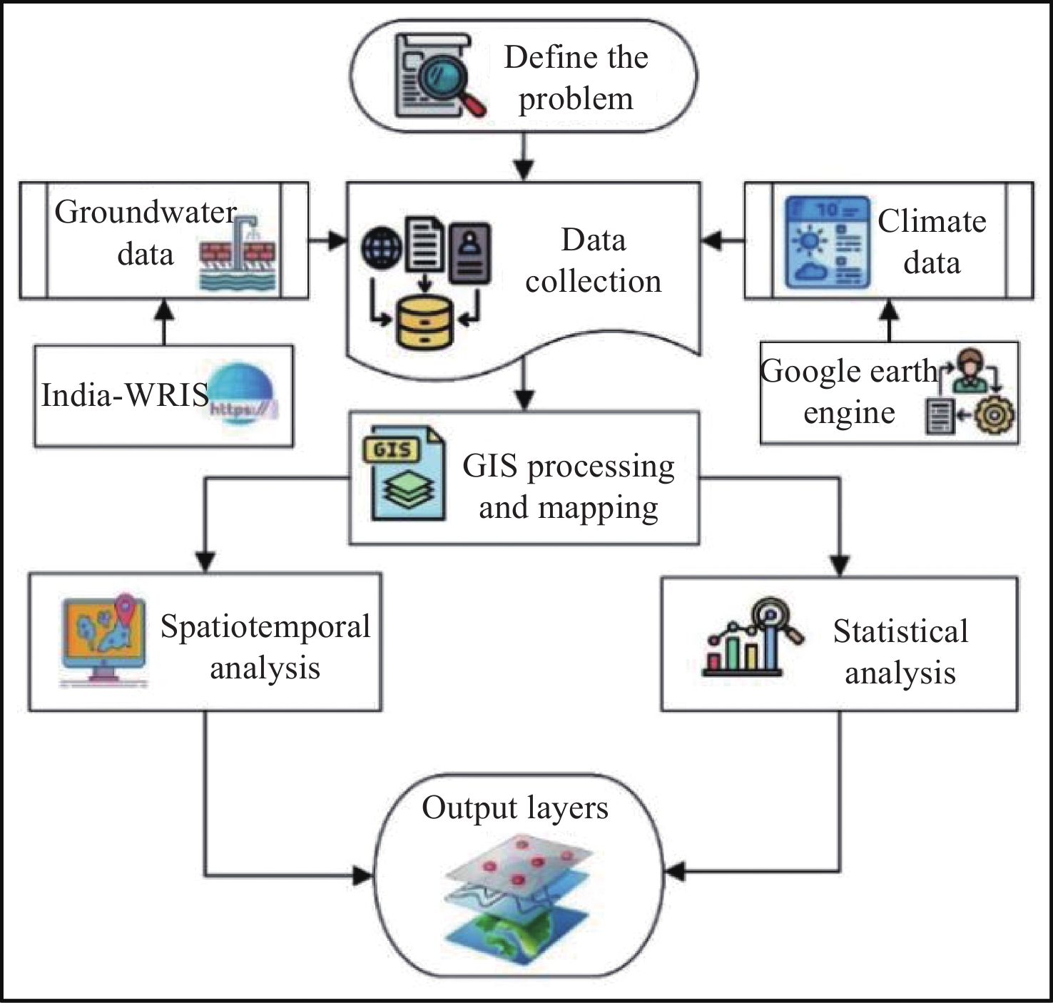
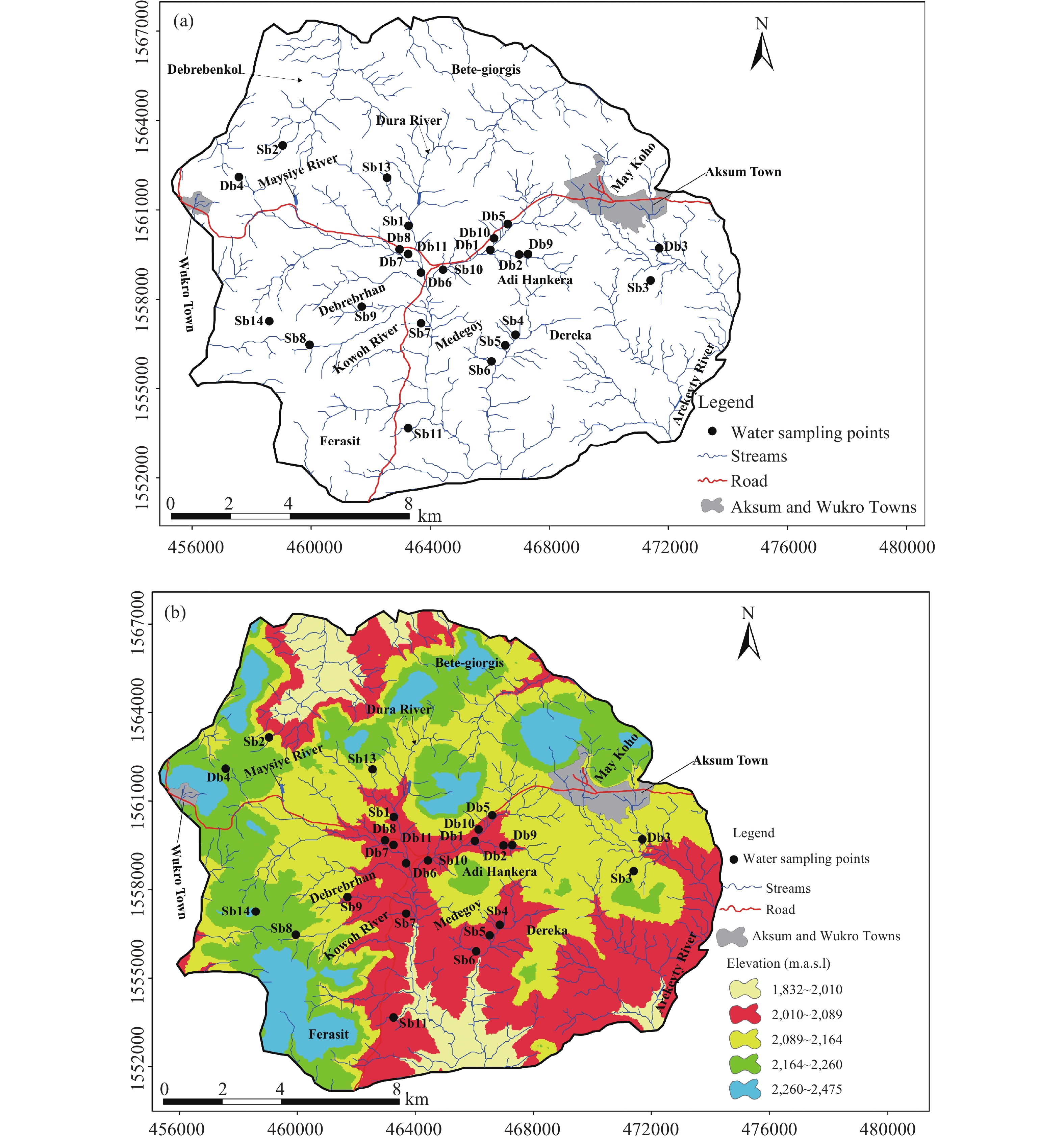
This study evaluates the suitability of irrigation water in the semi-arid region of Aksum, northern Ethiopia. An integrated approach combining the Irrigation Water Quality Index (IWQI) and ArcGIS-based spatial analysis was applied to assess the spatial variability of irrigation water quality. Twenty-five groundwater samples were collected and analyzed for key physicochemical parameters and heavy metals using standard laboratory techniques. Exceedances of recommended irrigation water limits were recorded for magnesium (16%), nitrate (32%), salinity hazard (12%), total dissolved solids (20%), total hardness (60%), residual sodium carbonate (16%), kelly index (4%), and magnesium ratio (32%). Based on the Irrigation Water Quality Index (IWQI), 36% of the samples fell under high restriction, 32% under moderate restriction, 24% under severe restriction, and 8% under low restriction for irrigation use. Although most of groundwater sources are suitable based on individual water quality parameters, the IWQI indicates that a significant portion of samples requires restricted use for irrigation. This highlights the need for targeted groundwater management strategies to mitigate localized risks associated with salinity and sodicity. The integrated IWQI-GIS approach demonstrated in this study is readily transferable to other arid and semi-arid regions, providing a robust tool for sustainable irrigation management and climate-resilient agricultural planning.
This study evaluates the suitability of irrigation water in the semi-arid region of Aksum, northern Ethiopia. An integrated approach combining the Irrigation Water Quality Index (IWQI) and ArcGIS-based spatial analysis was applied to assess the spatial variability of irrigation water quality. Twenty-five groundwater samples were collected and analyzed for key physicochemical parameters and heavy metals using standard laboratory techniques. Exceedances of recommended irrigation water limits were recorded for magnesium (16%), nitrate (32%), salinity hazard (12%), total dissolved solids (20%), total hardness (60%), residual sodium carbonate (16%), kelly index (4%), and magnesium ratio (32%). Based on the Irrigation Water Quality Index (IWQI), 36% of the samples fell under high restriction, 32% under moderate restriction, 24% under severe restriction, and 8% under low restriction for irrigation use. Although most of groundwater sources are suitable based on individual water quality parameters, the IWQI indicates that a significant portion of samples requires restricted use for irrigation. This highlights the need for targeted groundwater management strategies to mitigate localized risks associated with salinity and sodicity. The integrated IWQI-GIS approach demonstrated in this study is readily transferable to other arid and semi-arid regions, providing a robust tool for sustainable irrigation management and climate-resilient agricultural planning.
2026, 14(2): 148-164.
doi: 10.26599/JGSE.2026.9280076
Abstract:
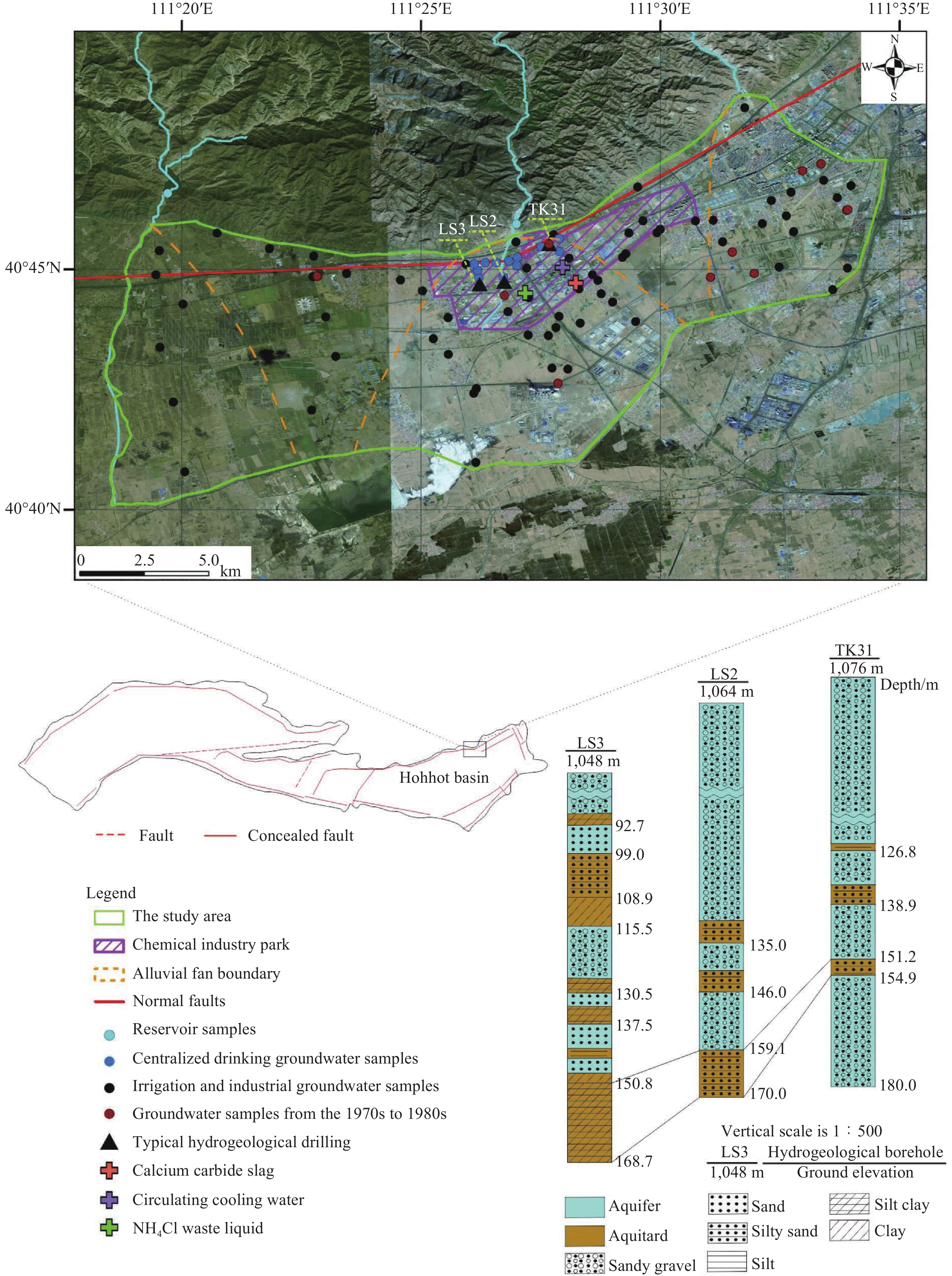
Natural Background Levels (NBLs) play a pivotal role in groundwater management. Ammonia nitrogen exceeding national standards is a significant concern in the alluvial fan area of Tuzuoqi, Hohhot, Inner Mongolia. The commonly used pre-selection method relies on empirical judgment with predefined pollution thresholds, making it highly subjective and less adaptable. In this study, an improved pre-selection approach was used to assess the NBLs of ammonia nitrogen and chlorides in the study area, complemented by pollution indices to evaluate the extent and scope of contamination. The improved method first employed Hierarchical Clustering Analysis (HCA) to identify characteristic pollution indicators, including NH4+, Cl−, TDS, Ca2+, Na+, NO3−, and Chlorinated HydroCarbons (CHCs). Subsequently, the contamination levels of these indicators were analyzed to establish pollution thresholds and remove contaminated samples, thereby completing the pre-selection of original samples. The pre-selection criteria for the study area were: For ammonia nitrogen, NH4+-N > 0.5 mg/L combined with Cl− > 250 mg/L; for chloride, Cl− > 250 mg/L and Cl− > 100 mg/L with simultaneous detection of CHCs. Pre-selected samples were further analyzed using Grubbs' test to identify NBLs samples. The validity of the NBLs samples was confirmed through significance tests based on historical data. The 95th percentile of the NBLs samples was used to calculate a unified NBLs for pollution indices. The results indicate that ammonia nitrogen contamination is concentrated in the central-southern part of the industrial park, with a limited spatial extent and severe pollution near pollution sources. The exceedances of ammonia nitrogen in water source wells are due to high NBLs, which are attributed to organic-rich alluvial-lacustrine interbedded deposits. Chloride pollution has spread from the central-southern to the northern areas, causing slight contamination in some wells over a broader region. Compared to other alluvial fans, elevated chloride NBLs are related to the high content of water-soluble salts in the lacustrine sediments within the strata. This study validates the effectiveness of the improved preselection method in determining groundwater NBLs and emphasizes the role of NBLs in identifying sources and contamination levels of exceeding components.
Natural Background Levels (NBLs) play a pivotal role in groundwater management. Ammonia nitrogen exceeding national standards is a significant concern in the alluvial fan area of Tuzuoqi, Hohhot, Inner Mongolia. The commonly used pre-selection method relies on empirical judgment with predefined pollution thresholds, making it highly subjective and less adaptable. In this study, an improved pre-selection approach was used to assess the NBLs of ammonia nitrogen and chlorides in the study area, complemented by pollution indices to evaluate the extent and scope of contamination. The improved method first employed Hierarchical Clustering Analysis (HCA) to identify characteristic pollution indicators, including NH4+, Cl−, TDS, Ca2+, Na+, NO3−, and Chlorinated HydroCarbons (CHCs). Subsequently, the contamination levels of these indicators were analyzed to establish pollution thresholds and remove contaminated samples, thereby completing the pre-selection of original samples. The pre-selection criteria for the study area were: For ammonia nitrogen, NH4+-N > 0.5 mg/L combined with Cl− > 250 mg/L; for chloride, Cl− > 250 mg/L and Cl− > 100 mg/L with simultaneous detection of CHCs. Pre-selected samples were further analyzed using Grubbs' test to identify NBLs samples. The validity of the NBLs samples was confirmed through significance tests based on historical data. The 95th percentile of the NBLs samples was used to calculate a unified NBLs for pollution indices. The results indicate that ammonia nitrogen contamination is concentrated in the central-southern part of the industrial park, with a limited spatial extent and severe pollution near pollution sources. The exceedances of ammonia nitrogen in water source wells are due to high NBLs, which are attributed to organic-rich alluvial-lacustrine interbedded deposits. Chloride pollution has spread from the central-southern to the northern areas, causing slight contamination in some wells over a broader region. Compared to other alluvial fans, elevated chloride NBLs are related to the high content of water-soluble salts in the lacustrine sediments within the strata. This study validates the effectiveness of the improved preselection method in determining groundwater NBLs and emphasizes the role of NBLs in identifying sources and contamination levels of exceeding components.
2026, 14(2): 165-187.
doi: 10.26599/JGSE.2026.9280077
Abstract:
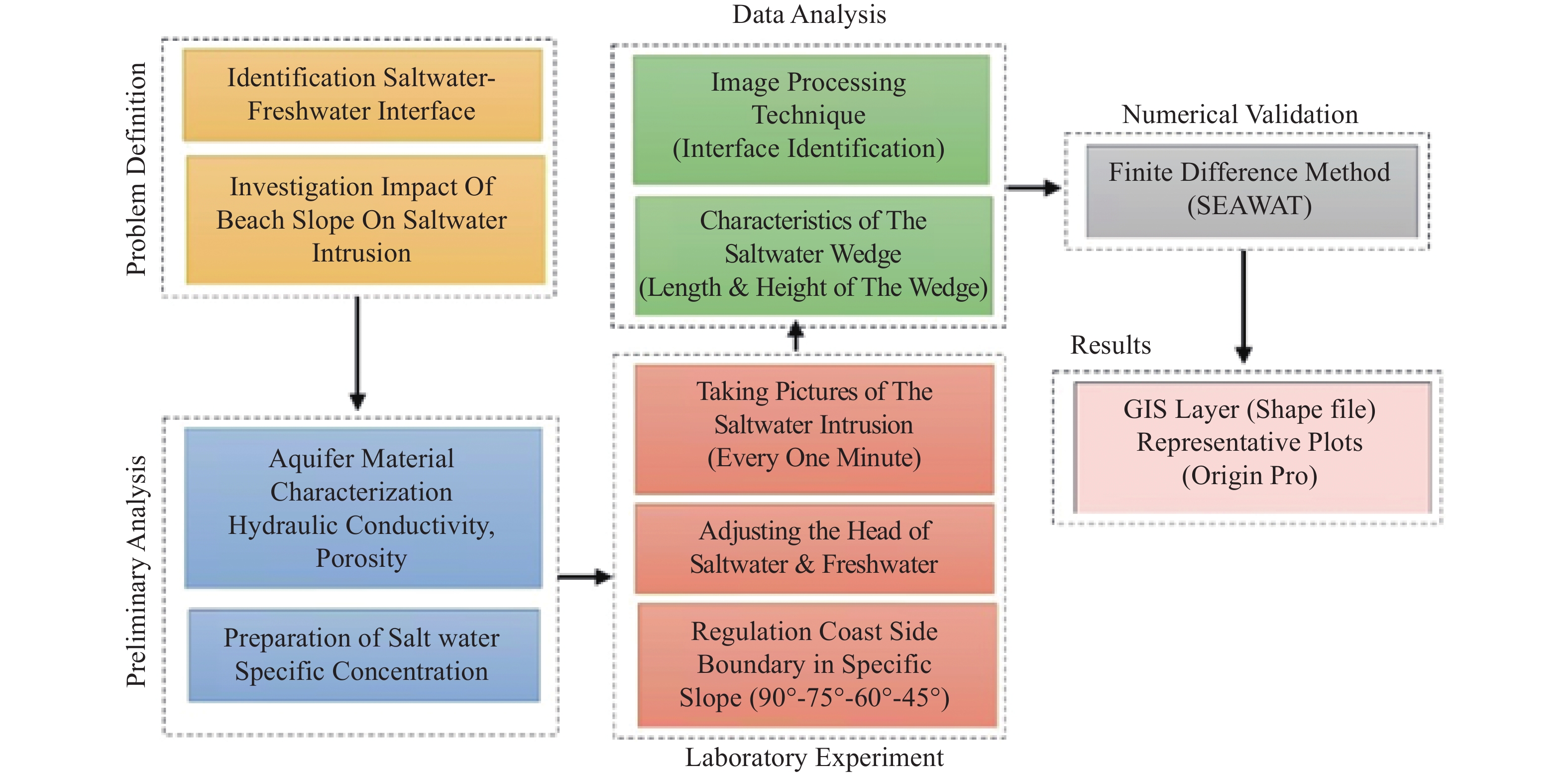
Over-exploitation of groundwater resources often causes seawater to intrude into coastal aquifers. This study aims to evaluate how different beach slopes (90°, 75°, 60°, and 45°) affect the extent and behavior of seawater intrusion in unconfined coastal aquifers under transient conditions. A three-dimensional laboratory model was constructed to simulate seawater intrusion under varying beach slopes. Experimental data were analyzed using image processing techniques, and results were validated using the SEAWAT numerical model. Key parameters—including wedge toe length, height, and area—were measured over time to assess the transient response of the saltwater wedge. The results showed that under static conditions, flatter slopes produced larger saltwater wedges. During transient conditions following a groundwater-level decline, the wedge toe advanced approximately 57% further in the vertical slope than in the 45° slope, while the final wedge size remained smaller on the steeper beach. The wedge height stabilized earlier than the toe length and area during intrusion, whereas in the recession stage, all three indices reached equilibrium almost simultaneously. The geometry of the beach slope has a significant effect on both the extent and temporal behavior of seawater intrusion. The toe length index showed a strong relationship with wedge area and can serve as a reliable indicator of intrusion volume under both steady and transient conditions. These findings emphasize the importance of considering beach slope in the design and management of coastal aquifer systems. Understanding how slope geometry influences the evolution of the saltwater wedge can improve the prediction and control of seawater intrusion in response to groundwater-level fluctuations.
Over-exploitation of groundwater resources often causes seawater to intrude into coastal aquifers. This study aims to evaluate how different beach slopes (90°, 75°, 60°, and 45°) affect the extent and behavior of seawater intrusion in unconfined coastal aquifers under transient conditions. A three-dimensional laboratory model was constructed to simulate seawater intrusion under varying beach slopes. Experimental data were analyzed using image processing techniques, and results were validated using the SEAWAT numerical model. Key parameters—including wedge toe length, height, and area—were measured over time to assess the transient response of the saltwater wedge. The results showed that under static conditions, flatter slopes produced larger saltwater wedges. During transient conditions following a groundwater-level decline, the wedge toe advanced approximately 57% further in the vertical slope than in the 45° slope, while the final wedge size remained smaller on the steeper beach. The wedge height stabilized earlier than the toe length and area during intrusion, whereas in the recession stage, all three indices reached equilibrium almost simultaneously. The geometry of the beach slope has a significant effect on both the extent and temporal behavior of seawater intrusion. The toe length index showed a strong relationship with wedge area and can serve as a reliable indicator of intrusion volume under both steady and transient conditions. These findings emphasize the importance of considering beach slope in the design and management of coastal aquifer systems. Understanding how slope geometry influences the evolution of the saltwater wedge can improve the prediction and control of seawater intrusion in response to groundwater-level fluctuations.
2026, 14(2): 188-198.
doi: 10.26599/JGSE.2026.9280078
Abstract:
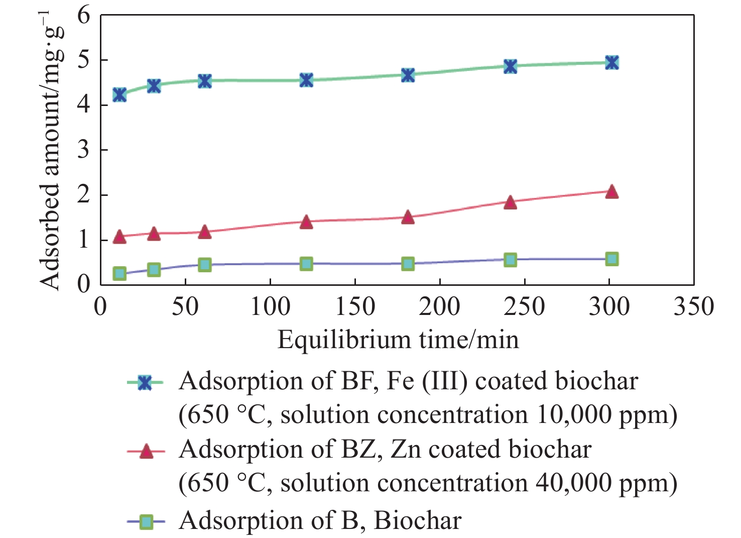
Nitrate contamination in water represents a significant threat to both public health and the environment. While ultrasonic technology has emerged as an eco-friendly approach with potential for enhancing nitrate removal, its full capacity remains underexplored. This study aims to assess the effectiveness of ultrasound in improving nitrate removal from aqueous solutions using biochar derived from rice straw, modified with Fe3+ and Zn2+ as cationic bridges. Conducted at the water quality laboratory of Sari Agricultural Sciences and Natural Resources University, the experiments revealed that iron-coated biochar treatments (BF and BFU) exhibited outstanding performance in nitrate removal. Ultrasound application significantly enhanced nitrate removal efficiency, with the combination of ultrasonic waves and iron-coated biochar (BFU) achieving a maximum adsorption capacity (qm) of 3.664 mg/g, which surpassed non-sonicated treatments (BF: 3.345 mg/g) and reduced equilibrium time by 92% (from 60 min to 5 min). Furthermore, ultrasonic treatment improved the performance of Zn2+-coated biochar (BZU), boosting removal rates by more than 25% through cavitation-induced particle fragmentation and enhanced mass transfer. Mechanistic analysis indicated that ultrasound facilitates the homogenization of the adsorption surface, favoring Langmuir-type monolayer adsorption (R2 > 0.95), while the cationic bridges (Fe3+/Zn2+) strengthened electrostatic interactions with nitrate ions. Under optimized conditions, the combination of ultrasound and cation-modified biochar achieved over 90% nitrate removal, presenting a promising, energy-efficient, and sustainable solution for water treatment. These findings demonstrate the potential of ultrasonic-assisted, cation-modified biochar as a highly effective strategy for mitigating nitrate contamination in water systems.
Nitrate contamination in water represents a significant threat to both public health and the environment. While ultrasonic technology has emerged as an eco-friendly approach with potential for enhancing nitrate removal, its full capacity remains underexplored. This study aims to assess the effectiveness of ultrasound in improving nitrate removal from aqueous solutions using biochar derived from rice straw, modified with Fe3+ and Zn2+ as cationic bridges. Conducted at the water quality laboratory of Sari Agricultural Sciences and Natural Resources University, the experiments revealed that iron-coated biochar treatments (BF and BFU) exhibited outstanding performance in nitrate removal. Ultrasound application significantly enhanced nitrate removal efficiency, with the combination of ultrasonic waves and iron-coated biochar (BFU) achieving a maximum adsorption capacity (qm) of 3.664 mg/g, which surpassed non-sonicated treatments (BF: 3.345 mg/g) and reduced equilibrium time by 92% (from 60 min to 5 min). Furthermore, ultrasonic treatment improved the performance of Zn2+-coated biochar (BZU), boosting removal rates by more than 25% through cavitation-induced particle fragmentation and enhanced mass transfer. Mechanistic analysis indicated that ultrasound facilitates the homogenization of the adsorption surface, favoring Langmuir-type monolayer adsorption (R2 > 0.95), while the cationic bridges (Fe3+/Zn2+) strengthened electrostatic interactions with nitrate ions. Under optimized conditions, the combination of ultrasound and cation-modified biochar achieved over 90% nitrate removal, presenting a promising, energy-efficient, and sustainable solution for water treatment. These findings demonstrate the potential of ultrasonic-assisted, cation-modified biochar as a highly effective strategy for mitigating nitrate contamination in water systems.
2026, 14(2): 199-212.
doi: 10.26599/JGSE.2026.9280079
Abstract:
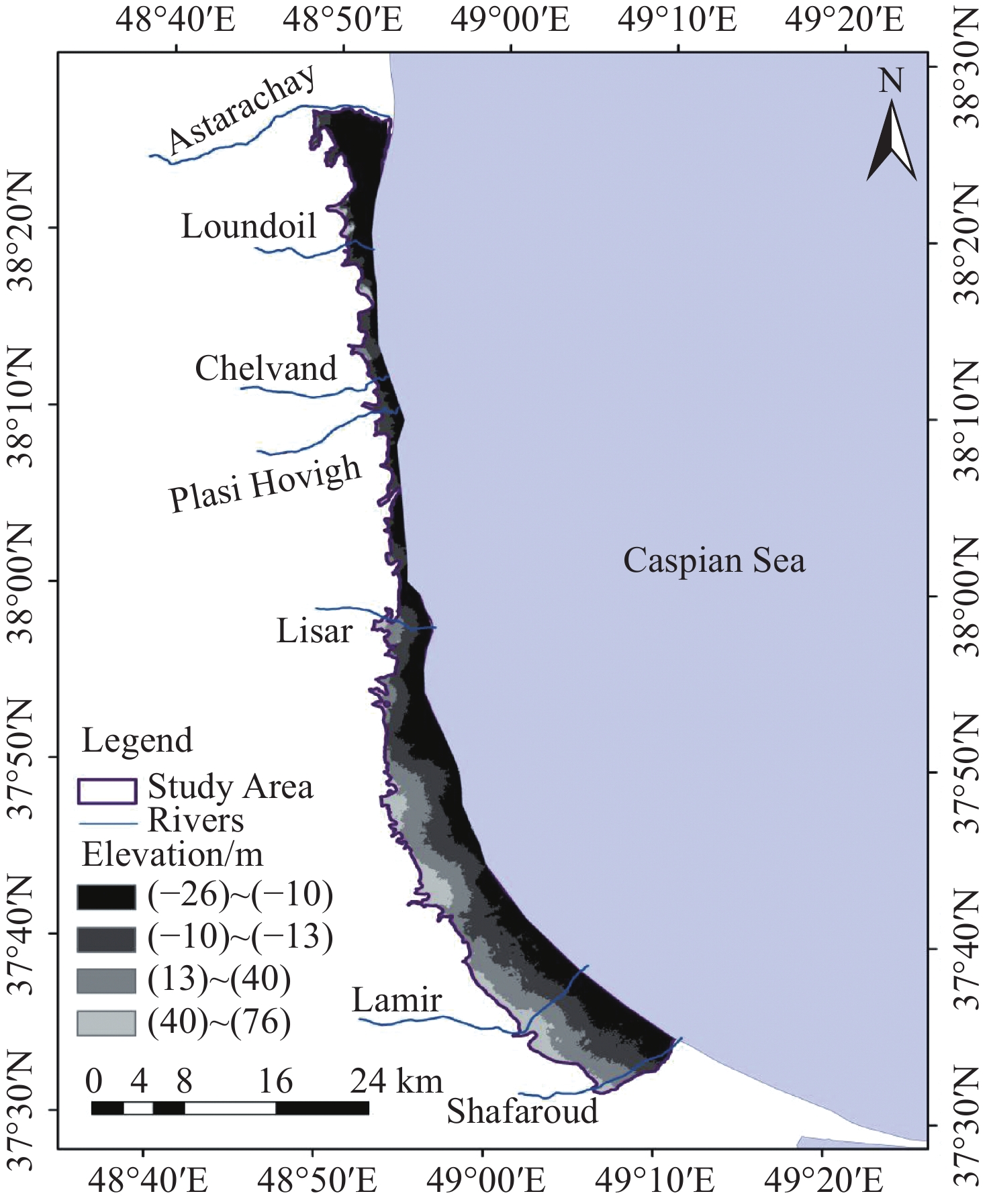
Groundwater resources are vital for sustaining agricultural productivity and ecological balance, particularly in regions facing increasing water demand and climatic variability. This study investigates the response of groundwater levels to different withdrawal scenarios in the Talesh aquifer, northern Iran, using MODFLOW (Modular Finite-Difference Groundwater Flow Model) integrated with the Groundwater Modeling System (GMS) software (Version 10.4). The model was calibrated and validated using observed data from 2005 to 2018 under both steady and transient conditions. Seven scenarios of groundwater extraction were simulated, including 5%, 10% and 15% increases and decreases relative to the baseline withdrawal rates, to evaluate potential impacts on groundwater storage and sustainability from 2019 to 2024. Statistical indices such as Root Mean Square Error (RMSE), Mean Absolute Error (MAE) and Mean Error (ME) confirmed the model's reliability in reproducing observed groundwater levels. Results indicated that maintaining current groundwater withdrawal rates leads to continued groundwater level declines of up to approximately 3.12 m in localized areas of the aquifer, whereas a 15% reduction in groundwater withdrawals can result in substantial groundwater recovery, with water level rises exceeding 2.40 m at specific locations during the simulation period. The results of this study highlight the critical necessity of groundwater withdrawal management policies to balance groundwater withdrawal with natural recharge, ensure water security and support sustainable agriculture.
Groundwater resources are vital for sustaining agricultural productivity and ecological balance, particularly in regions facing increasing water demand and climatic variability. This study investigates the response of groundwater levels to different withdrawal scenarios in the Talesh aquifer, northern Iran, using MODFLOW (Modular Finite-Difference Groundwater Flow Model) integrated with the Groundwater Modeling System (GMS) software (Version 10.4). The model was calibrated and validated using observed data from 2005 to 2018 under both steady and transient conditions. Seven scenarios of groundwater extraction were simulated, including 5%, 10% and 15% increases and decreases relative to the baseline withdrawal rates, to evaluate potential impacts on groundwater storage and sustainability from 2019 to 2024. Statistical indices such as Root Mean Square Error (RMSE), Mean Absolute Error (MAE) and Mean Error (ME) confirmed the model's reliability in reproducing observed groundwater levels. Results indicated that maintaining current groundwater withdrawal rates leads to continued groundwater level declines of up to approximately 3.12 m in localized areas of the aquifer, whereas a 15% reduction in groundwater withdrawals can result in substantial groundwater recovery, with water level rises exceeding 2.40 m at specific locations during the simulation period. The results of this study highlight the critical necessity of groundwater withdrawal management policies to balance groundwater withdrawal with natural recharge, ensure water security and support sustainable agriculture.
2026, 14(2): 213-232.
doi: 10.26599/JGSE.2026.9280080
Abstract:
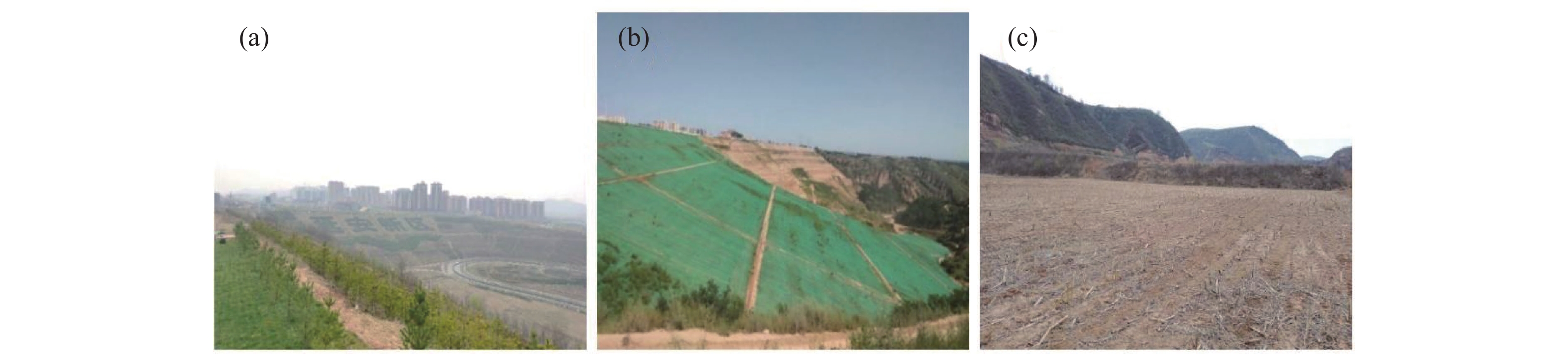
The extensive fill engineering slopes formed by major projects such as "managing the ditch and creating land" in the Loess Plateau region face severe challenges of rainfall-induced instability. Inspired by the self-stable structure of natural loess-paleosol sequences and the Nature-based Solutions (NbS) concept, the water-control structure for loess fill slopes was propose, which is a composite of erosion-resistant surface layer (modified cellulose-treated) and low-permeability layers (mimicking paleosol properties using lime-improved loess). Indoor soil mechanics tests (liquid/plastic limits, compaction, permeability, shear strength) and Scanning Electron Microscopy (SEM) analysis revealed that both modified materials significantly enhance soil strength and reduce permeability (e.g., lime treatment reduced saturated permeability by 95.18%). Artificial rainfall model experiments demonstrated that slopes with water—control structure exhibit delayed infiltration response (up to 1,565 minutes), reduced erosion volume (71.6% less than untreated slopes), and shifted failure modes from fluidized collapse to gradual shear-slip. Numerical simulations (GeoStudio) further optimized the low-permeability layer configuration, identifying a 3 m-thick, 2°-inclined layer as optimal for maximizing stability. This study reveals that the NbS structure effectively regulates rainfall infiltration and erosion processes, significantly reducing erosion volume and altering failure modes. Consequently, the NbS-based water-control structure provides a theoretical basis and key technical support for the prevention and control of instability in loess fill slopes.
The extensive fill engineering slopes formed by major projects such as "managing the ditch and creating land" in the Loess Plateau region face severe challenges of rainfall-induced instability. Inspired by the self-stable structure of natural loess-paleosol sequences and the Nature-based Solutions (NbS) concept, the water-control structure for loess fill slopes was propose, which is a composite of erosion-resistant surface layer (modified cellulose-treated) and low-permeability layers (mimicking paleosol properties using lime-improved loess). Indoor soil mechanics tests (liquid/plastic limits, compaction, permeability, shear strength) and Scanning Electron Microscopy (SEM) analysis revealed that both modified materials significantly enhance soil strength and reduce permeability (e.g., lime treatment reduced saturated permeability by 95.18%). Artificial rainfall model experiments demonstrated that slopes with water—control structure exhibit delayed infiltration response (up to 1,565 minutes), reduced erosion volume (71.6% less than untreated slopes), and shifted failure modes from fluidized collapse to gradual shear-slip. Numerical simulations (GeoStudio) further optimized the low-permeability layer configuration, identifying a 3 m-thick, 2°-inclined layer as optimal for maximizing stability. This study reveals that the NbS structure effectively regulates rainfall infiltration and erosion processes, significantly reducing erosion volume and altering failure modes. Consequently, the NbS-based water-control structure provides a theoretical basis and key technical support for the prevention and control of instability in loess fill slopes.
2026, 14(2): 233-251.
doi: 10.26599/JGSE.2026.9280081
Abstract:
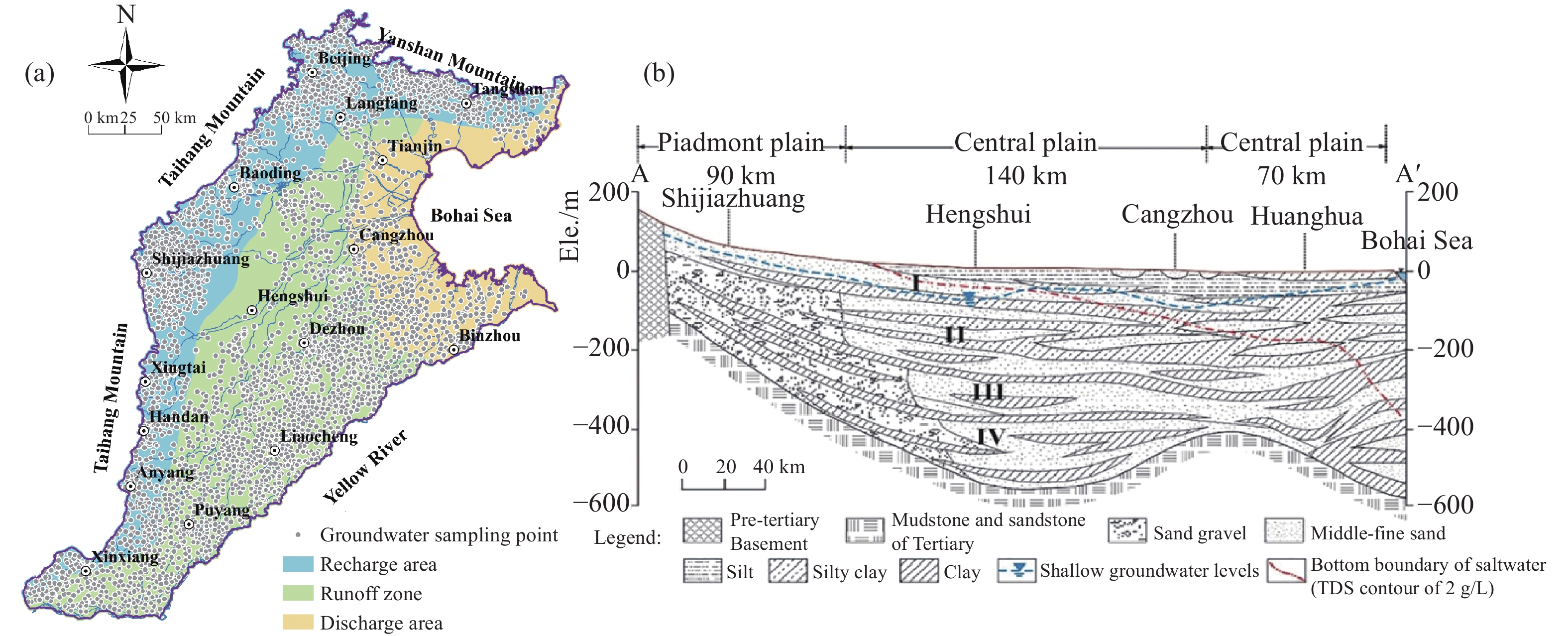
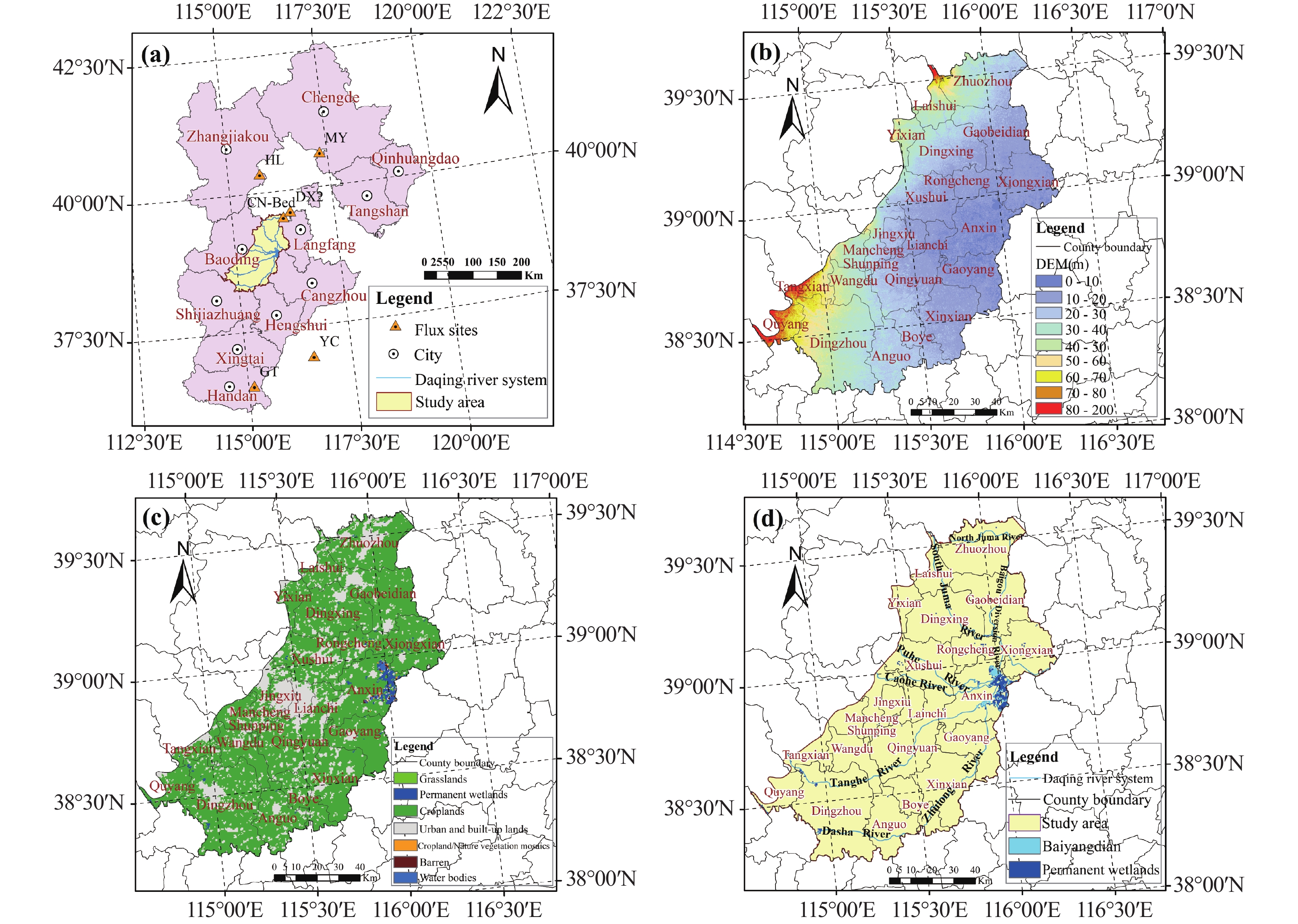
Evapotranspiration (ET) is a core parameter of the hydrology and carbon cycles, and its accurate estimation is crucial for water resource management. Satellite-based ET products provide an effective means for large-scale monitoring. However, due to limitations in the spatial and temporal resolution, the use of these products at regional and field scales is limited. In this study, daily ET in the Baoding Plain—a key groundwater resource recharge area—was estimated at a 500 m spatial resolution using the Bayesian Model Averaging (BMA) method. The model was driven by a synthesis of remote sensing datasets, reanalysis products, and interpolated data from meteorological stations. Validation results from in-situ observations indicated that the BMA ET had better performance (R=0.83, RMSE=1.25 mm/d) than each model in the BMA scheme. The spatiotemporal analysis revealed that the average annual BMA ET in the Baoding Plain was 683 mm/year from 2000 to 2019. Seasonal and monthly variations in the BMA ET captured the irrigation and water consumption patterns of the local crop rotation systems. A significant increasing trend of BMA ET (2.40 mm/year2) was observed in the Baoding Plain over the study period. At the regional scale, ET over more than 50% of the plain exhibited a significant positive trend. Further analysis identified water availability, solar radiation, and temperature as the primary drivers of ET variation. The BMA ET product generated in this study is characterized by high spatiotemporal resolution and accuracy. This reliable, high-resolution dataset offers valuable support for precision agricultural water management and hydrological studies, including groundwater investigations, in this predominantly agricultural region.
Evapotranspiration (ET) is a core parameter of the hydrology and carbon cycles, and its accurate estimation is crucial for water resource management. Satellite-based ET products provide an effective means for large-scale monitoring. However, due to limitations in the spatial and temporal resolution, the use of these products at regional and field scales is limited. In this study, daily ET in the Baoding Plain—a key groundwater resource recharge area—was estimated at a 500 m spatial resolution using the Bayesian Model Averaging (BMA) method. The model was driven by a synthesis of remote sensing datasets, reanalysis products, and interpolated data from meteorological stations. Validation results from in-situ observations indicated that the BMA ET had better performance (R=0.83, RMSE=1.25 mm/d) than each model in the BMA scheme. The spatiotemporal analysis revealed that the average annual BMA ET in the Baoding Plain was 683 mm/year from 2000 to 2019. Seasonal and monthly variations in the BMA ET captured the irrigation and water consumption patterns of the local crop rotation systems. A significant increasing trend of BMA ET (2.40 mm/year2) was observed in the Baoding Plain over the study period. At the regional scale, ET over more than 50% of the plain exhibited a significant positive trend. Further analysis identified water availability, solar radiation, and temperature as the primary drivers of ET variation. The BMA ET product generated in this study is characterized by high spatiotemporal resolution and accuracy. This reliable, high-resolution dataset offers valuable support for precision agricultural water management and hydrological studies, including groundwater investigations, in this predominantly agricultural region.
2026, 14(2): 252-270.
doi: 10.26599/JGSE.2026.9280082
Abstract:
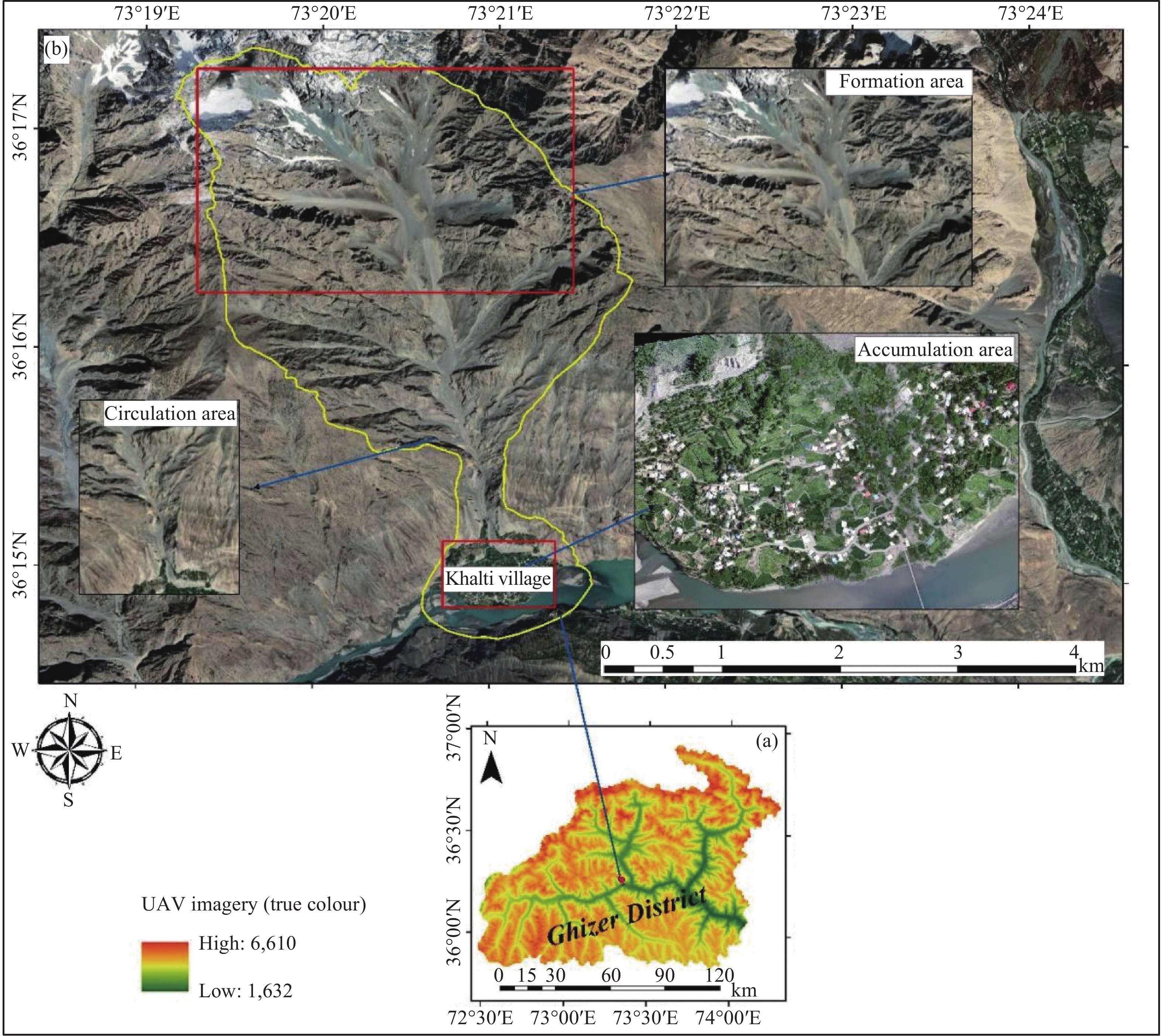
Northern Pakistan is highly susceptible to debris flows due to its complex geomorphic structure, steep topography, climate change, glaciation, monsoonal rainfall, active seismicity, deforestation, and human activities. Despite this, high-resolution, quantitative assessments of debris flow hazards are limited, constraining effective disaster risk management. This study aims to model a representative debris flow event in the Ghizer District to predict potential deposition areas and support emergency preparedness and sustainable land-use planning in this hazard-prone region. High-resolution Unmanned Aerial Vehicle (UAV)-derived topographic data were integrated with the Rapid Mass Movement Simulation (RAMMS-DF) model to simulate debris flow runout for three release scenarios, representing distinct and combined initiation zones. Satellite images and field validation were used to delineate release and erosion zones, while vulnerability and risk were assessed by mapping exposed elements including 210 buildings and a population of 1,500 and applying spatial multi-criteria analysis within a Geographic Information System (GIS) framework. The numerical simulation for the most critical event, Scenario 3 (representing simultaneous dual-source initiation), yielded the highest magnitude results with a total flow volume of 193,717 m3, a peak flow height of 12.96 m, and a maximum impact pressure of 992.28 kPa. Vulnerability mapping identified infrastructure and agricultural land as the most exposed. Risk assessment showed that the combined scenario posed the greatest threat to local assets and communities. The study demonstrates that debris flow dynamics in high-mountain environments are non-linearly sensitive to initial release volumes and the interaction between multiple flow sources. Topographic controls such as channel confinement and slope variations are the primary drivers of flow intensity and energy dissipation. This research establishes a replicable, data-driven framework for quantitative risk assessment in data-limited mountainous regions. The resulting high-resolution hazard and risk maps provide a scientific basis for defining land-use restrictions, prioritizing slope stabilization, and guiding the placement of emergency infrastructure to support disaster-resilient development in northern Pakistan.
Northern Pakistan is highly susceptible to debris flows due to its complex geomorphic structure, steep topography, climate change, glaciation, monsoonal rainfall, active seismicity, deforestation, and human activities. Despite this, high-resolution, quantitative assessments of debris flow hazards are limited, constraining effective disaster risk management. This study aims to model a representative debris flow event in the Ghizer District to predict potential deposition areas and support emergency preparedness and sustainable land-use planning in this hazard-prone region. High-resolution Unmanned Aerial Vehicle (UAV)-derived topographic data were integrated with the Rapid Mass Movement Simulation (RAMMS-DF) model to simulate debris flow runout for three release scenarios, representing distinct and combined initiation zones. Satellite images and field validation were used to delineate release and erosion zones, while vulnerability and risk were assessed by mapping exposed elements including 210 buildings and a population of 1,500 and applying spatial multi-criteria analysis within a Geographic Information System (GIS) framework. The numerical simulation for the most critical event, Scenario 3 (representing simultaneous dual-source initiation), yielded the highest magnitude results with a total flow volume of 193,717 m3, a peak flow height of 12.96 m, and a maximum impact pressure of 992.28 kPa. Vulnerability mapping identified infrastructure and agricultural land as the most exposed. Risk assessment showed that the combined scenario posed the greatest threat to local assets and communities. The study demonstrates that debris flow dynamics in high-mountain environments are non-linearly sensitive to initial release volumes and the interaction between multiple flow sources. Topographic controls such as channel confinement and slope variations are the primary drivers of flow intensity and energy dissipation. This research establishes a replicable, data-driven framework for quantitative risk assessment in data-limited mountainous regions. The resulting high-resolution hazard and risk maps provide a scientific basis for defining land-use restrictions, prioritizing slope stabilization, and guiding the placement of emergency infrastructure to support disaster-resilient development in northern Pakistan.

 Online Submission
 Peer Review
 Office Work
 Editor-in-chief
1.9
Impact Factor(2025)
3.7
CiteScore 2025
Editor-in-ChiefLI Qing-hua
Sponsors
Institute of Hydrogeology and Environmental Geology (IHEG), CAGS
China Chapter, International Association of Hydrogeologists (IAH-CC)
Commission on Hydrogeology, Geological Society of China(GSC-CH)
 NewsMORE+
- Pooling Academic Wisdom to Drive the Journal's International Development, High-Quality Growth Editorial Board of Journal of Groundwater Science and Engineering Holds a Series of Strategic Seminars for High-Quality Growth2026/07/08
- Fraud prevention statement2026/05/06
- 防诈骗严正声明2026/05/06
- 以镜观水,以图载学-----诚邀投稿封面图片2026/04/22
- Special Issue on “Monitoring, Migration, and Prevention-Control of Emerging Contaminants in Groundwater”2026/04/01
- “地下水新污染物监测、迁移与防控”专辑征稿通知2026/04/01
- ”地下水水质与污染研究“专辑征稿通知2026/03/11
 DownloadMORE+
Top ViewedMORE+
- Using geospatial technologies to delineate Ground Water Potential Zones (GWPZ) in Mberengwa and Zvishavane District, Zimbabwe
- Assessment of porous aquifer hydrogeological parameters using automated groundwater level measurements in Greece
- Application of HYDRUS-1D in understanding soil water movement at two typical sites in the North China Plain
- Ecosystem-driven karst carbon cycle and carbon sink effects
- Artesian Flowing Wells Field of Phu Tok Aquifer
Top DownloadedMORE+
- Construction of ecological environment of oasis in Qingtongxia Irrigation District
- Analysis of bromate and bromide in drinking water by ion chromatography-inductively coupled plasma mass spectrometry
- Application of HYDRUS-1D in understanding soil water movement at two typical sites in the North China Plain
- Artesian Flowing Wells Field of Phu Tok Aquifer
- Study on the residence time of deep groundwater for high-level radioactive waste geological disposal
 Links
Links


