• ISSN 2305-7068
  • Indexed by ESCI CABI CAS
  • DOAJ EBSCO Scopus GeoRef AJ CNKI
Advanced Search

2020 Vol. 8, No. 2

Display Method:
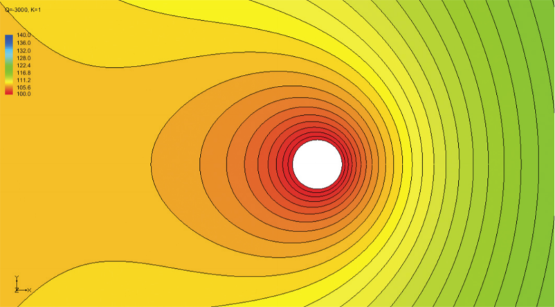
Development of a simple method for determining the influence radius of a pumping well in steady-state condition
A S El-Hames
2020, 8(2): 97-107. doi: 10.19637/j.cnki.2305-7068.2020.02.001
Abstract(1975) PDF(310)
Abstract:

Influence radius of a pumping well is a crucial parameter for hydrogeologists and engineers. Knowing the radius of influence for a designed drawdown enables one to calculate the pumping rate required to layout a project foundation that may need lowering of groundwater level to a certain depth due to dewatering operation. In addition, this is important for hydrogeologists to determine ground water contamination flow paths and contributing recharge area for domestic water supply and aquifer management purposes. Empirical formulas that usually neglect vital parameters to determine the influence radius accurately have been traditionally utilized due to lack of adequate methods. In this study, a physically based method, which incorporates aquifer hydraulic gradient for determining the influence radius of a pumping well in steady-state flow condition, was developed. It utilizes Darcy and Dupuit laws to calculate the influence radius, where Darcy’s law and Dupuit equation, in steady-state condition, represent the inflow and the outflow of the pumping well, respectively. In an untraditional manner, this method can be also used to determine aquifer hydraulic conductivity as an alternative to other pumping test methods with high degree of accuracy. The developed method is easy to use; where a simple mathematical calculator may be used to calculate the influence radius and the pumping rate or hydraulic conductivity. By comparing the results from this method with the MODFLOW numerical model outputs with different simulated scenarios, it is realized that this method is much superior and more advantageous than other commonly used empirical methods.

Experimental study on height simulation of capillary fringe
ZHANG Bing, GAO Ye-xin, FENG Xin, ZHANG Ya-zhe, LIU Ji-chao, ZHANG Ying-ping
2020, 8(2): 108-117. doi: 10.19637/j.cnki.2305-7068.2020.02.002
Abstract(506) PDF(121)
Abstract:
In this paper, the plexiglass experimental column was used to analyze the capillary fringe thickness of three kinds of lithologies-silty sand, silt and silty clay-providing a basis for defining the interface in the study of hydrodynamics at the water table between vandose water and groundwater. The capillary fringe generally refers to the subsurface layer in which the groundwater seeps up to the air-entry suction value due to capillary action, and is nearly saturated with water. The thickness of the capillary fringe varies with different lithologies. In this experiment, self-made stable water supply devices were used to study the height of capillary rise, capillary water volume and capillary fringe thickness of the three lithologies through capillary experiment and numerical simulation. Experimental results show as follows: (1) Rising height of capillary water is related to time, particle radius, volume, etc., and the relationship between height and time is in line with the Hill model. (2) The smaller the particle radius, the more water the pores contain, and the ratio of the unsaturated portion of capillary water to the total water content gradually rises. Experimental results obtained by numerical simulation, segmentation and actual measurement are consistent. (3) The thickness of the capillary zone is related to the lithology. The larger the particle size, the smaller the thickness of the capillary fringe, and vice versa. In silty sand, the thickness measures about 13 cm. The figure rises to 16 cm in silt, and 37 cm in silty clay. This work studies the law of soil water transport at saturated-unsaturated interface. Experimental results are of great significance to the study of soil water and salt transport and soil salinization control in unsaturated zone.
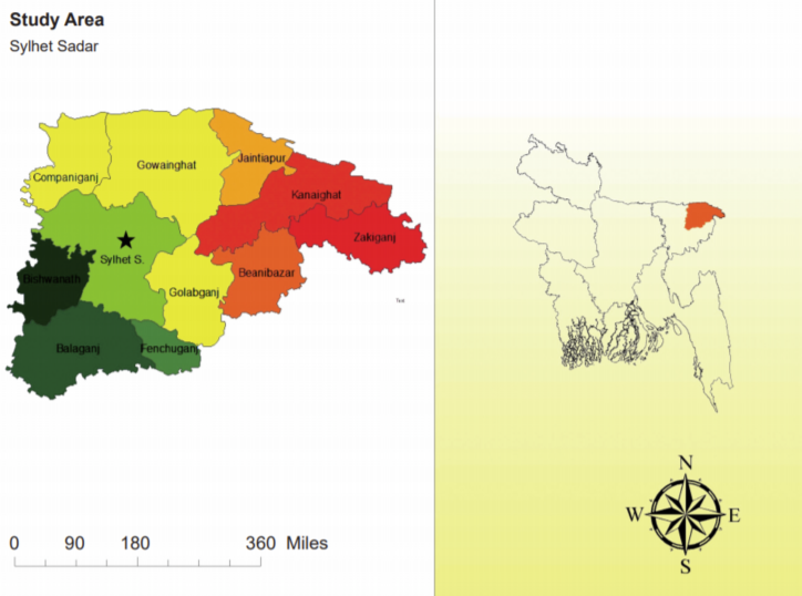
NARX neural network approach for the monthly prediction of groundwater levels in Sylhet Sadar, Bangladesh
Abdullah Al Jami, Meher Uddin Himel, Khairul Hasan, Shilpy Rani Basak, Ayesha Ferdous Mita
2020, 8(2): 118-126. doi: 10.19637/j.cnki.2305-7068.2020.02.003
Abstract(931) PDF(238)
Abstract:

Groundwater is important for managing the water supply in agricultural countries like Bangladesh. Therefore, the ability to predict the changes of groundwater level is necessary for jointly planning the uses of groundwater resources. In this study, a new nonlinear autoregressive with exogenous inputs (NARX) network has been applied to simulate monthly groundwater levels in a well of Sylhet Sadar at a local scale. The Levenberg-Marquardt (LM) and Bayesian Regularization (BR) algorithms were used to train the NARX network, and the results were compared to determine the best architecture for predicting monthly groundwater levels over time. The comparison between LM and BR showed that NARX-BR has advantages over predicting monthly levels based on the Mean Squared Error (MSE), coefficient of determination (R2), and Nash-Sutcliffe coefficient of efficiency (NSE). The results show that BR is the most accurate method for predicting groundwater levels with an error of ± 0.35 m. This method is applied to the management of irrigation water source, which provides important information for the prediction of local groundwater fluctuation at local level during a short period.

Study on the standards of 1:50 000 hydrogeological maps in China
WEN Xue-ru, CHENG Yan-pei, WU Ai-min, DONG Hua, YI Qing, LIU Kun
2020, 8(2): 127-133. doi: 10.19637/j.cnki.2305-7068.2020.02.004
Abstract(417) PDF(119)
Abstract:
In compilation of 1: 50 000 hydrogeological map, Some principles which are suitable for hydrogeological characteristics in China have been defined. Groundwater development and protection have been regarded as equally important. Some key problems such as classification of water-bearing formation, water yield property, color system and color scale of water yield property of water-bearing formation, expression of groundwater system, expression of hydrogeological parameters have been solved. This standardizing work can lay solid foundation for integration of 1: 50 000 synthetic hydrogeological map achievement and data, so as to broaden the service areas of hydrogeological survey.
Characteristics of geothermal reservoirs and utilization of geothermal resources in the southeastern coastal areas of China
ZHANG Ying, LUO Jun, FENG Jian-yun
2020, 8(2): 134-142. doi: 10.19637/j.cnki.2305-7068.2020.02.005
Abstract(717) PDF(110)
Abstract:
Based on regional geological setting, stratigraphic distribution and other geological conditions, this paper summarized three types of geothermal reservoirs in the southeast coastal areas of China: Cenozoic sandstone or sandy conglomerate reservoir, Mesozoic granite fissure reservoir and Paleozoic karst reservoir. Cenozoic sandstone or sandy conglomerate reservoirs are mainly located in Cenozoic basins, such as Zhangzhou, Fuzhou, Sanshui and Leiqiong basins. The Tertiary sedimentary basins such as Leiqiong Basin and Sanshui Basin, are controlled by NE-trending faults, while the Quaternary sedimentary such as Zhangzhou and Fuzhou basins are controlled by NW-trending faults. Mesozoic granite fissure reservoirs are mainly distributed in the southeast coastal areas, such as Zhangzhou, Fuzhou, Fengshun, Yangjiang and southern part of Hainan Province. The distribution of good Mesozoic granite fissure reservoir in these areas is mainly controlled by NE-trending faults. Paleozoic carbonate reservoirs are widely distributed in these areas. Most carbonate rocks are from the upper Paleozoic strata, such as those in the area of Huizhou in Guangdong Province. The major types of geothermal systems in the southeast coastal areas of China belong to medium and low temperature convection. The geothermal resources developed from the ground to -3 000 m underground could be utilized directly for space heating, greenhouse heating, aquaculture pond heating and industrial uses, as well as other purposes. The geothermal resources with a depth of 3 000~6 000 m underground is mainly featured by Hot Dry Rock (HDR) with a temperature ranges from 150 °C to 200 °C, which is conductive to the development of Enhanced Geothermal System (EGS) and can be utilized for power generation.
Spatial and statistical assessment of nitrate contamination in groundwater: Case of Sais Basin, Morocco
Abdelhakim LAHJOUJ, Abdellah EL HMAIDI, Karima BOUHAFA
2020, 8(2): 143-157. doi: 10.19637/j.cnki.2305-7068.2020.02.006
Abstract(2459) PDF(238)
Abstract:
The objective of this study is to evaluate the nitrate contamination in the plioquaternary aquifer of Sais Basin based on a statistical approach. A total of 98 samples were collected in the cultivated area during the spring and autumn period of 2018. The results show that 55% and 57% of the samples in spring and autumn respectively exceed the threshold fixed by WHO (50 mg/L). However, nitrate concentrations do not show seasonal and spatial variation (p>0.05). The results of the correlation matrix, principal component analysis (PCA), and hierarchical cluster analysis (HCA) suggest that nitrate pollution is related to anthropogenic source. Moreover, multiple linear regression results show that NO3 is more positively explained in the spring period by Ca and SO4 and negatively explained by pH and HCO3. Regarding the autumn period, nitrate pollution is positively explained by Ca and negatively by pH. This study proposes a useful statistical platform for assessing nitrate pollution in groundwater.
Determination of the origin of mineralization and groundwater salinity in the Adrar region in the southwest of Algeria
KHELFAOUI Hakim, DAJBRI Larbi, LAKHAL Fatima Zohra, CHAFFAI Hicham, HANI Azzedine, SAYAD Lamine
2020, 8(2): 158-171. doi: 10.19637/j.cnki.2305-7068.2020.02.007
Abstract(558) PDF(127)
Abstract:
To some extent, the sedimentary sequence with the largest groundwater reserves in northern Sahara is marked by a certain water table level, regionally known as the “Continental Intercalaire” (CI). “Continental Intercalaire” (CI) refers to “Continental Intercalar” widely distributed among three countries. Algeria, Tunisia and Libya, which have significant potential of water resources. As it is the only water resource relatively easily accessible to the inhabitants of the Sahara, it is widely developed. The physico-chemical characteristics of statistical processing in principal component analysis (PCA) and the chemical phase measurement of groundwater in the unconfined aquifer captured by “Foggaras” (traditional system irrigation composed of well system linked by a horizontal channel from their bases) and the deep drillings located in the study area were accessible. Therefore, there were some favorable conditions for comparing the chemistry of these waters with the standards of potability established by the World Health Organization. Then, the study detected the origin of excessive mineralization and the excessive content of Na, Cl, K, Mg and Ca that originated from the leaching of the clay and carbonate layers of the “Continental Intercalaire”. In addition, the enrichment in NO2-, NO3- and SO42- was due to the excessive use of fertilizer in the whole region for shallower Foggaras waters, and this study also showed the dominant chemical facies of groundwater related to the significant abundance of these mineral salts in this thick aquifer horizon.
Recognition of the hydrogeological potential using electrical sounding in the KhemissetTiflet region, Morocco
Fatima Zahra FAQIHI, Anasse BENSLIMANE, Abderrahim LAHRACH, Mohamed CHIBOUT, Mohamed EL MOKHTAR
2020, 8(2): 172-179. doi: 10.19637/j.cnki.2305-7068.2020.02.008
Abstract(1026) PDF(164)
Abstract:
The low recharge of reservoirs and the increasing demand for water limit the potential of mobilized resources, especially in arid to semi-arid areas like Morocco. Integrated management is essential to safeguard this resource. In respect with this perspective, this work provides the analysis of hydrogeological potential of Khemisset-Tiflet region, which falls within the action area of the Sebou Hydraulic Basin Agency. The basis of our studies was as follows: (1) The interpretation of the existing geoelectric data; (2) application of geophysical methods for non-destructive reconnaissance and their integration into a Geographic Information System (GIS). The analysis demonstrates that: The map of the isohypses and the geoelectric cross-section of the substratum of the superficial roof aquifer show clearly a plunge associated with development of the Paleozoic roof in the South and the direction of flow of the surface water is from south to north, from the upper zone to the north of the El Kansera dam. These conclusions constitute very useful contribution for any resource management projects in this area.
Delineation of potential groundwater zones based on multicriteria decision making technique
Dinagarapandi Pandi, Saravanan Kothandaraman, Mohan Kuppusamy
2020, 8(2): 180-194. doi: 10.19637/j.cnki.2305-7068.2020.02.009
Abstract(1414) PDF(350)
Abstract:
Groundwater is the most prioritized water source in India and plays an indispensable role in India’s economy. The groundwater potential mapping is key to the sustainable groundwater development and management. A hybrid methodology is applied to delineate potential groundwater zones based on remote sensing, geographical information systems (GIS) and analytic hierarchy process (AHP) as on multicriteria decision making. For the purpose of demonstrating field application, Chittar watershed, Tamilnadu, India is studied as an example. The important morphological characteristics considered in the study are lithology, geomorphology, lineament density, drainage density, slope, and Soil Conservation Service-Curve Number (SCS-CN). These six thematic layers are generated in a GIS platform. Based on intersecting the layers, AHP method, the values for adopting the pairwise comparison normalized weight and normalized subclasses weightage were given. The normalized subclass weightage is input into each layer subclass. Then, weighted linear combination method is used to add the data layers in GIS platform to generate groundwater potential Index (GWPI) map. The GWPI map is validated based on the net recharge computed from the differences of measured groundwater levels between the pre-monsoon and post-monsoon in the year 2018. The kappa statistics are used to measure level spatial consistency between the GWPI and net recharge map. The overall average spatial matching accuracy between the two data sets is 0.86, while the kappa coefficient for GWPI with net recharge, 0.78. The results show that in Chittar watershed about 870 km2 area is divided into high potential zone (i.e. sum of very high and high potential zone), 667 km2 area, as the moderate one and the rest 105 km2 area, as the poor zone (i.e. sum of very poor and poor potential zone).

JGSE-ScholarOne Manuscript Launched on June 1, 2024.

Online Submission