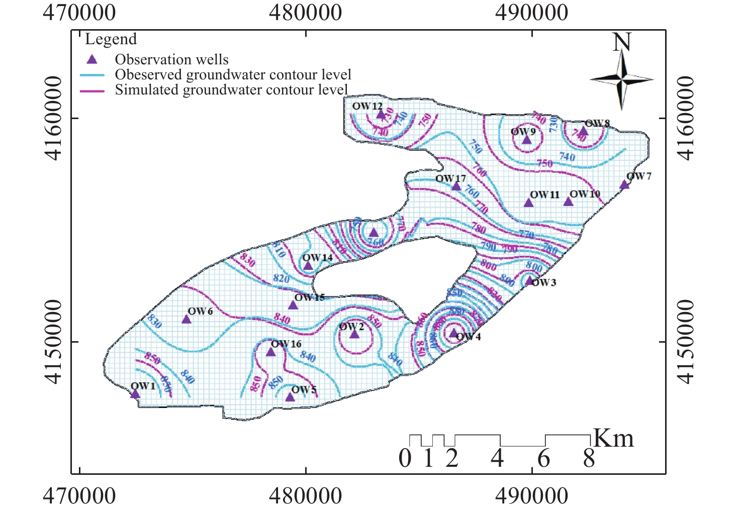
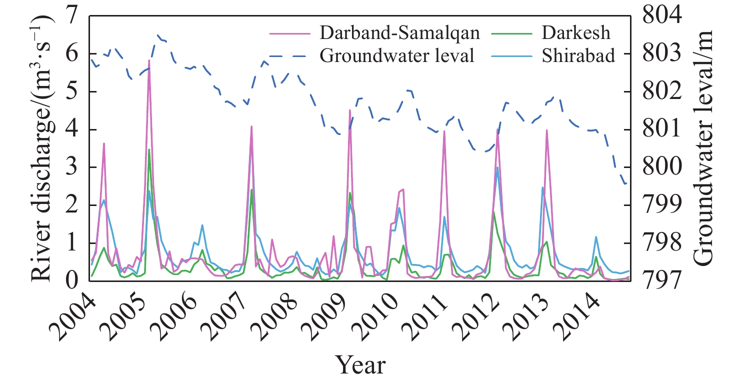
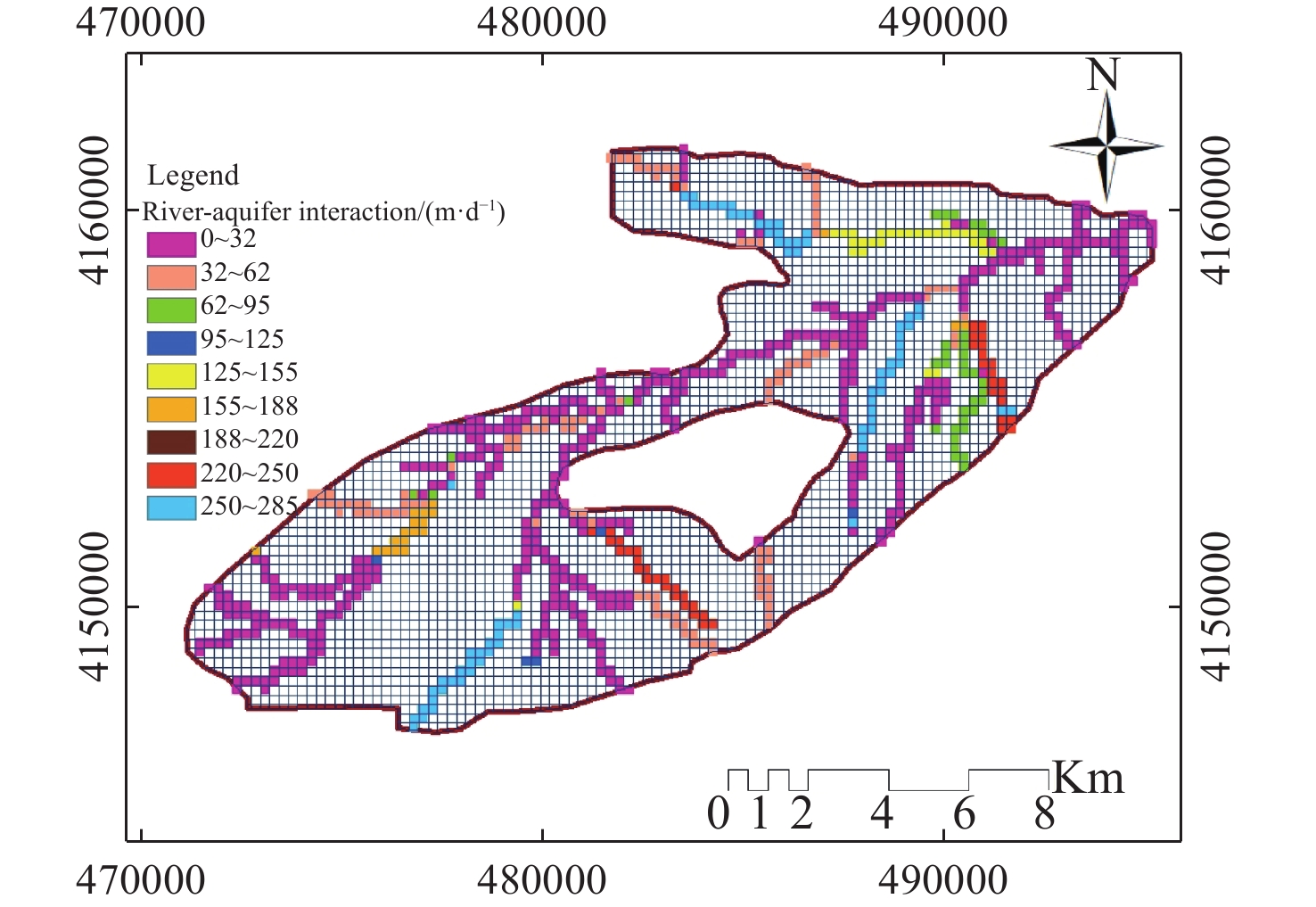
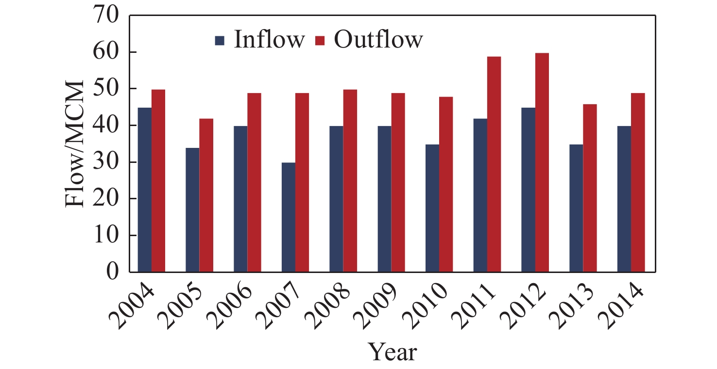
• ISSN 2305-7068
  • Indexed by ESCI CABI CAS
  • DOAJ Scopus GeoRef AJ CNKI
Advanced Search

2022 Vol. 10, No. 1

Display Method:
Analysis of groundwater level trend in Jakham River Basin of Southern Rajasthan
Vinay Kumar Gautam, Mahesh Kothari, P.K. Singh, S.R. Bhakar, K.K. Yadav
2022, 10(1): 1-9. doi: 10.19637/j.cnki.2305-7068.2022.01.001
Abstract(1094) FullText HTML (512) PDF(153)
Abstract:
Groundwater accounts for about half of the water use for irrigation in India. The fluctuation pattern of the groundwater level is examined by observing rainfall replenishment and monitoring wells. The southern part of Rajasthan has experienced abrupt changes in rainfall and has been highly dependent on groundwater over decades. This study presents the impact of over-dependence on groundwater usage for irrigation and other purposes, spatially and temporally. Hence, the objective of this study is to examine the groundwater level trend by using statistical analysis and geospatial technique. Rainfall factor was also studied in groundwater level fluctuation during 2009-2019. To analyze the influence of each well during recharge or withdrawal of groundwater, thiessien polygonswere generated from them. In the Jakham River basin, 75 wells have been identified for water level trend study using the Mann-Kendall statistical test. The statistics of trend analysis show that 15% wells are experiencing water level decline in pre-monsoon, while very low percentage of wells have such trend during post-monsoon season. The average rate of water level decline is 0.245 m/a in pre-monsoon and 0.05 m/a in post-monsoon. The aquifer recharge potential is also decreasing by year.it is expected that such type of studies will help the policy makers to adopt advanced management practices to ensure sustainable groundwater resource management.
Groundwater exploration using integrated geophysics method in hard rock terrains in Mount Betung Western Bandar Lampung, Indonesia
Rustadi, I Gede Boy Darmawan, Nandi Haerudin, Agus Setiawan, Suharno
2022, 10(1): 10-18. doi: 10.19637/j.cnki.2305-7068.2022.01.002
Abstract(790) FullText HTML (354) PDF(91)
Abstract:
The presence of hard rock in Mount Betung has caused the misalignment of the groundwater aquifers, and resulted in many drilling failures for groundwater. An integrated geophysics method using gravity survey and Geoelectric Vertical Electrical Soundings (VES) were conducted to study the effect of basement and hard rock on groundwater prospects. From the gravity method, 38 mapping points were carried out randomly, with a distance of 1-2 km in-between. Meanwhile, from the geoelectric method, 51 VES points were acquired at the foot of Mount Betung. The acquisition was conducted with a Schlumberger configuration with AB/2 = 1 m to 250 m. The results show the Bouguer Anomaly in the west is 50-68 mgal due to the presence of hard rock in Mount Betung. This anomaly responds to relatively shallow hard rocks near surface. Hard rocks composed of andesite and breccia normally present at the depth of 5-180 m during well construction. Resistivity isopach mapping from VES data (at AB/2 = 50 m, 100 m, and 150 m) shows the dominant constituents of hard rock. Fractures in hard rock contribute to secondary porosity, which could be a prospect zone that transmit groundwater. This finding shows that the fractures are randomly scattered, causing several well failures that have been worked. Furthermore, the fractures in the hard rock at the foot of Mount Betung acts as conduits between recharge at Mount Betung and the aquifer in the Bandar Lampung Basin.
Variation characteristics of CO2 in a newly-excavated soil profile, Chinese Loess Plateau: Excavation-induced ancient soil organic carbon decomposition
Chao Song, Man Liu, Qiu-yao Dong, Lin Zhang, Pan Wang, Hong-yun Chen, Rong Ma
2022, 10(1): 19-32. doi: 10.19637/j.cnki.2305-7068.2022.01.003
Abstract(641) FullText HTML (270) PDF(53)
Abstract:
Soils of the Chinese Loess Plateau (CLP) contain substantial amounts of soil inorganic carbon (SIC), as well as recent and ancient soil organic carbon (SOC). With the advent of the Anthropocene, human perturbation, including excavation, has increased soil CO2 emission from the huge loess carbon pool. This study aims to determine the potential of loess CO2 emission induced by excavation. Soil CO2 were continuously monitored for seven years on a newly-excavated profile in the central CLP and the stable C isotope compositions of soil CO2 and SOC were used to identify their sources. The results showed that the soil CO2 concentrations ranged from 830 μL·L−1 to 11 190 μL·L−1 with an annually reducing trend after excavation, indicating that the human excavation can induce CO2 production in loess profile. The δ13C of CO2 ranged from –21.27 ‰ to –19.22 ‰ (mean: –20.11‰), with positive deviation from top to bottom. The range of δ13CSOC was –24.0‰ to –21.1‰ with an average of –23.1‰. The δ13C-CO2 in this study has a positive relationship with the reversed CO2 concentration, and it is calculated that 80.22% of the soil CO2 in this profile is from the microbial decomposition of SOC and 19.78% from the degasification during carbonate precipitation. We conclude that the human excavation can significantly enhance the decomposition of the ancient OC in loess during the first two years after perturbation, producing and releasing soil CO2 to atmosphere.
Experimental and numerical investigation of groundwater head losses on and nearby short intersections between disc-shaped fractures
Ci-xiao Qu, Ming-yu Wang, Peng Wang
2022, 10(1): 33-43. doi: 10.19637/j.cnki.2305-7068.2022.01.004
Abstract(455) FullText HTML (202) PDF(33)
Abstract:
Discrete fracture models are used for investigating precise processes of groundwater flow in fractured rocks, while a disc-shaped parallel-plates model for a single fracture is more reasonable and efficient for computational treatments. The flow velocity has a large spatial differentiation which is more likely to produce non-linear flow and additional head losses on and nearby intersections in such shaped fractures, therefore it is necessary to understand and quantify them. In this study, both laboratory experiments and numerical simulations were performed to investigate the total head loss on and nearby the intersections as well as the local head loss exactly on the intersections, which were not usually paid sufficient attention or even ignored. The investigation results show that these two losses account for 29.17%-84.97% and 0-73.57% of the entire total head loss in a fracture, respectively. As a result, they should be necessarily considered for groundwater modeling in fractured rocks. Furthermore, both head losses become larger when aperture and flow rate increase and intersection length decreases. Particularly, the ratios of these two head losses to the entire total head loss in a fracture could be well statistically explained by power regression equations with variables of aperture, intersection length, and flow rates, both of which achieved high coefficients of determination. It could be feasible through this type of study to provide a way on how to adjust the groundwater head from those obtained by numerical simulations based on the traditional linear flow model. Finally, it is practicable and effective to implement the investigation approach combining laboratory experiments with numerical simulations for quantifying the head losses on and nearby the intersections between disc-shaped fractures.
Determination of water balance equation components in irrigated agricultural watersheds using SWAT and MODFLOW models : A case study of Samalqan plain in Iran
Shima Nasiri, Hossein Ansari, Ali Naghi Ziaei
2022, 10(1): 44-56. doi: 10.19637/j.cnki.2305-7068.2022.01.005
Abstract(547) FullText HTML (238) PDF(43)
Abstract:
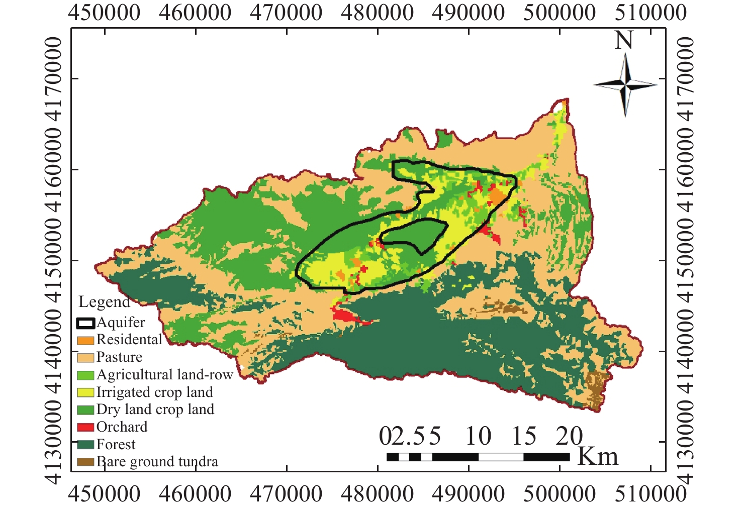
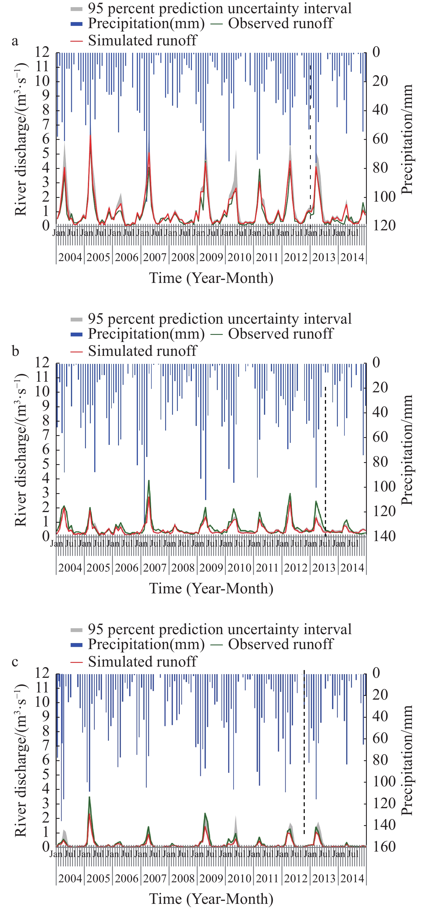
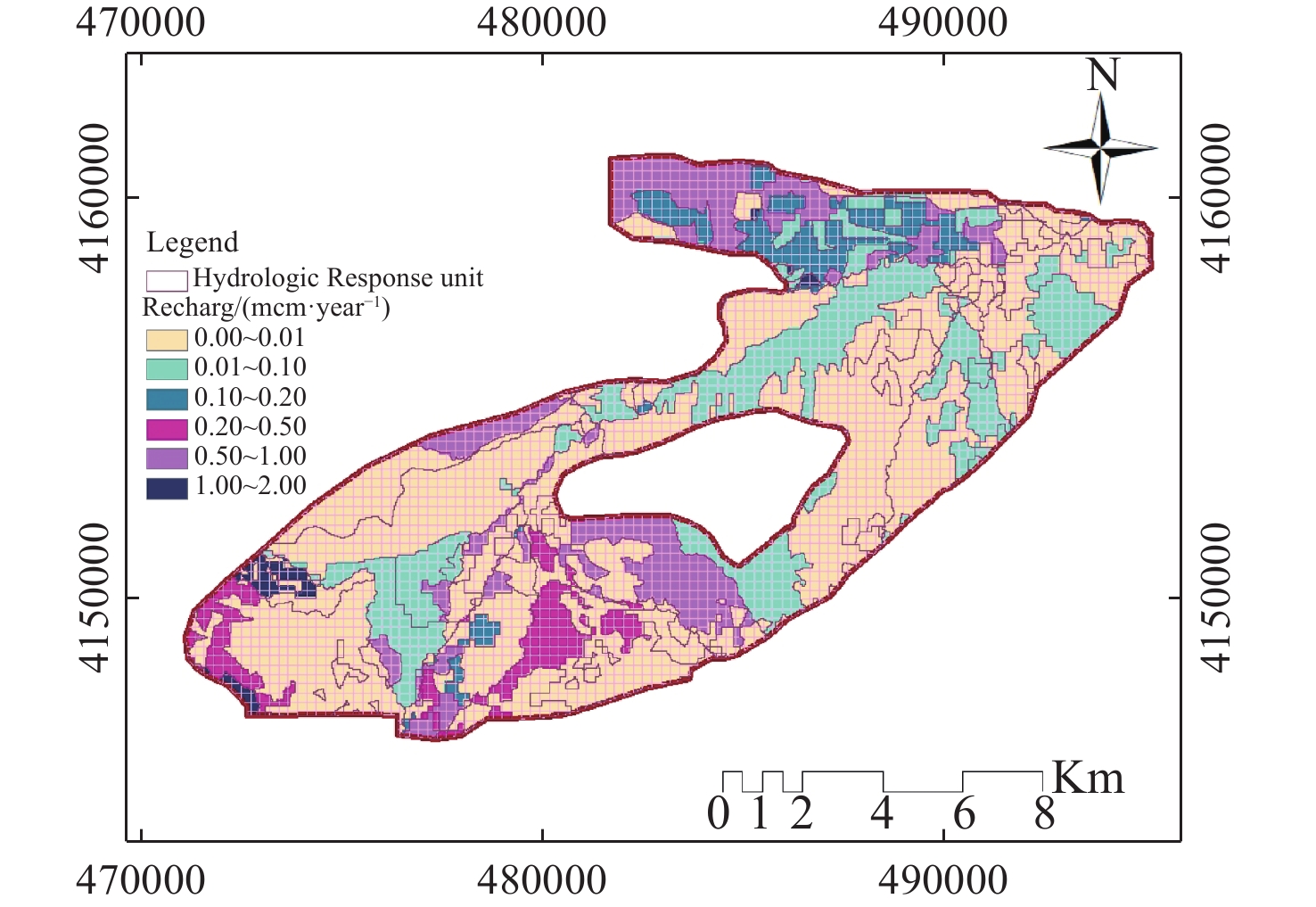
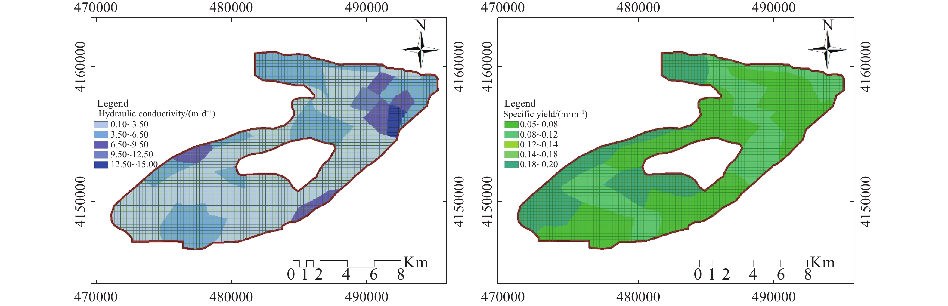
Increasing water demands, especially in arid and semi-arid regions, continuously exacerbate groundwater as the only reliable water resources in these regions. Samalqan watershed, Iran, is a groundwater-based irrigation watershed, so that increased aquifer extraction, has caused serious groundwater depletion. So that the catchment consists of surface water, the management of these resources is essential in order to increase the groundwater recharge. Due to the existence of rivers, the low thickness of the alluvial sediments, groundwater level fluctuations and high uncertainty in the calculation of hydrodynamic coefficients in the watershed, the SWAT and MODFLOW models were used to assess the impact of irrigation return flow on groundwater recharge and the hydrological components of the basin. For this purpose, the irrigation operation tool in the SWAT model was utilized to determine the fixed amounts and time of irrigation for each HRU (Hydrological Response Unit) on the specified day. Since the study area has pressing challenges related to water deficit and sparsely gauged, therefore, this investigation looks actual for regional scale analysis. Model evaluation criteria, RMSE and NRMSE for the simulated groundwater level were 1.8 m and 1.1% respectively. Also, the simulation of surface water flow at the basin outlet, provided satisfactory prediction (R2=0.92, NSE=0.85). Results showed that, the irrigation has affected the surface and groundwater interactions in the watershed, where agriculture heavily depends on irrigation. Annually 11.64 Mm3 water entered to the aquifer by surface recharge (precipitation, irrigation), transmission loss from river and recharge wells 5.8 Mm3 and ground water boundary flow (annually 20.5 Mm3). Water output in the watershed included ground water extraction and groundwater return flow (annually 46.4 Mm3) and ground water boundary flow (annually 0.68 Mm3). Overally, the groundwater storage has decreased by 9.14 Mm3 annually in Samalqan aquifer. This method can be applied to simulate the effects of surface water fluxes to groundwater recharge and river-aquifer interaction for areas with stressed aquifers where interaction between surface and groundwater cannot be easily assessed.
Managed aquifer recharge (MAR) applications in China–achievements and challenges
Jin-xing Guo, Zhi-ping Li, Catalin Stefan
2022, 10(1): 57-69. doi: 10.19637/j.cnki.2305-7068.2022.01.006
Abstract(573) FullText HTML (261) PDF(53)
Abstract:
Groundwater is of fundamental significance for human society, especially in semi-arid areas in China. However, due to the fast social and economic development, China has been suffering from the shortage of water resource. In this situation, managed aquifer recharge (MAR) was considered to be an effective measure for the sustainable management of groundwater resources. Since 1960s, China successfully implemented many MAR schemes for different purposes such as restoration of groundwater tables, prevention of seawater intrusion, increasing urban water supplies and controlling land subsidence. From those successful experiences China developed a scientific and applicable system to implement MAR project. However, there were still many challenges in this field, for example, treated waste water had been barely used for recharge. The present review summarized the achievements in MAR applications in China as well as the associated challenges within the past 55 years before the year 2016.
Indication of hydrogen and oxygen stable isotopes on the characteristics and circulation patterns of medium-low temperature geothermal resources in the Guanzhong Basin, China
Feng Ma, Gui-ling Wang, Hong-li Sun, Zhan-xue Sun
2022, 10(1): 70-86. doi: 10.19637/j.cnki.2305-7068.2022.01.007
Abstract(458) FullText HTML (182) PDF(39)
Abstract:
Guanzhong Basin is a typical medium-low temperature geothermal field mainly controlled by geo-pressure in the west of China. The characteristics of hydrogen and oxygen isotopes were used to analyze the flow and storage modes of geothermal resources in the basin. In this paper, the basin was divided into six geotectonic units, where a total of 121 samples were collected from geothermal wells and surface water bodies for the analysis of hydrogen-oxygen isotopes. Analytical results show that the isotopic signatures of hydrogen and oxygen throughout Guanzhong Basin reveal a trend of gradual increase from the basin edge areas to the basin center. In terms of recharge systems, the area in the south edge belongs to the geothermal system of Qinling Mountain piedmont, while to the north of Weihe fault is the geothermal system of North mountain piedmont, where the atmospheric temperature is about 0.2℃-1.8℃ in the recharge areas. The main factors that affect the geothermal water δ18O drifting include the depth of geothermal reservoir and temperature of geothermal reservoir, lithological characteristics, water-rock interaction, geothermal reservoir environment and residence time. The δ18O-δD relation shows that the main source is the meteoric water, together with some sedimentary water, but there are no deep magmatic water and mantle water which recharge the geothermal water in the basin. Through examining the distribution pattern of hydrogen-oxygen isotopic signatures, the groundwater circulation model of this basin can be divided into open circulation type, semi-open type, closed type and sedimentary type. This provides some important information for rational exploitation of the geothermal resources.
Using pore-solid fractal dimension to estimate residual LNAPLs saturation in sandy aquifers: A column experiment
Lin Sun, Shuai-wei Wang, Cai-juan Guo, Chan Shi, Wei-chao Su
2022, 10(1): 87-98. doi: 10.19637/j.cnki.2305-7068.2022.01.008
Abstract(462) FullText HTML (169) PDF(38)
Abstract:
: The“tailing” effect caused by residual non-aqueous phase liquids (NAPLs) in porous aquifers is one of the frontiers in pollution hydrogeology research. Based on the current knowledge that the residual NAPLs is mainly controlled by the pore structure of soil, this study established a method for evaluating the residual saturation of NAPLs by investigating the fractal dimension of porous media. In this study, the soil column experiments of residual light NAPLs (LNAPLs) in sandy aquifer with different ratios of sands and soil were carried out, and the correlation between the fractal dimension of the medium, the residual of LNAPLs and the soil structure parameters are statistically analyzed, and its formation mechanism and main control factors are discussed. The results show that: Under our experimental condition: (1) the fractal dimension of the medium has a positive correlation with the residual saturation of NAPLs generally, and the optimal fitting function can be described by a quadratic model: ${S_R} = {\text{192}}{\text{.02}}{D^2} - 890.73D + {\text{1 040}}{\text{.8}}$; (2) the dominant formation mechanism is: Smaller pores in the medium is related to larger fractal dimension, which leads to higher residual saturation of NAPLs; stronger heterogeneity of the medium is related to larger fractal dimension, which also leads to higher residual saturation of NAPLs; (3) the micro capillary pores characterized by fine sand are the main controlling factors of the formation mechanism. It is concluded that both the theory and the method of using fractal dimension of the medium to evaluate the residual saturation of NAPLs are feasible. This study provides a new perspective for the research of “tailing” effect of NAPLs in porous media aquifer.

Welcome to Journal of Groundwater Science and  Engineering!

Quick Submit

Online Submission   E-mail Submission