 E-mail alert
 Rss
Rss



Estimation of the water potential index under dynamic hydromorphological conditions on ephemeral river watersheds
-
Abstract: Land morphology and water resources are typically linked through hydromorphological processes, particularly in ephemeral river systems. This study used the Vaigai, Gundar, and Vaippar watersheds in Tamil Nadu, India, as a case study to investigate this link. Land terrain morphology was analysed using the morphometric analysis. Empirical models were developed using morphological parameters to estimate runoff and sediment rates. The water resources, specifically runoff and groundwater, were quantified using an overall water potential index derived from the Multi-Criteria Decision-Making (MCDM) technique. The MCDM technique employed the Analytical Hierarchy Process (AHP) in combination with fuzzy set theory. Seven hydromorphological thematic layers—lithology, lineament density, geomorphology, soil, land use, drainage density, and slope were addressed using the fuzzy-AHP method. Hydrogeological models incoporated available aquifer properties of the subsurface structure, derived from GIS-based weighted overlay and hydrological analysis. A significant finding of morphometric analysis was the identification of high runoff and sediment rates at the smallest sub-watersheds. Furthermore, the water potential index indicated a high surface water (runoff) potential associated with vertisol in the soil and hornblende-biotite gneiss in the lithology, particularly in the Vaippar and Gundar downstream sub-watersheds. The Vaigai and Gundar downstream sub-watersheds had a significant groundwater potential due to their mild slopes and dynamic floodplains. The surface water and groundwater potential indices showed 71% and 87% efficiency, respectively, when compared to runoff from the empirical model and field groundwater recharge. Similar patterns of high potential were observed in downstream watersheds from the hydrogeological models. These findings may help alleviate the depletion of surface and subsurface water resources in sub-watersheds by identifying sites for rainwater harvesting for future climatic scenarios.
-
Key words:
- Watersheds /
- Water resources /
- Multi-criteria decision-making /
- Fuzzy set /
- Analytical hierarchy process /
- Rainwater harvesting
Major terms Aster-GDEM v3 Advanced Spaceborne Thermal Emission and Reflection Radiometer Global Digital Elevation Model Version 3 AHP Analytical Hierarchy Process GIS Geographic Information System GSI Geological Survey of India GPI Groundwater Potential Index LULC Land Use/Land Cover MCDM Multi-Criteria Decision-Making NBSS- LUP National Bureau of Soil Survey-Land Use Planning PERSIANN Precipitation Estimation from Remotely Sensed Information using Artificial Neural Networks ROC Receiver Operating Characteristic SWAT Soil and Water Assessment Tool SWPI Surface Water Potential Index VGV Vaigai, Gundar, and Vaippar Notations Cc Constant Channel Maintenance Dd Drainage density Di Dissection index Fs Stream frequency Gr Gradient Ratio H Relief ratio Lb Watershed length Lg Length of overland flow Msl Mean stream length O Stream order Rb Mean Bifurcation ratio Rc Circulatory ratio Re Elongation ratio Rf Form factor Rn Ruggedness number SLR Stream length ratio T Drainage texture Tsl Total stream length Wr Watershed relief CR Consistency Ratio Ci Consistency Index Ri Random Index NR Normalized Weight GM Geometric Mean FM Fuzzy Mean Matrix FNR Fuzzy Normalized Weight WNR Overall Normalized Weight Index Greek letter λ eigenvalues of thematic data Subscripts n number of thematic classes f Fuzzy sets I Index for Consistency Index and Random Index
注释:1) Abbreviations: -
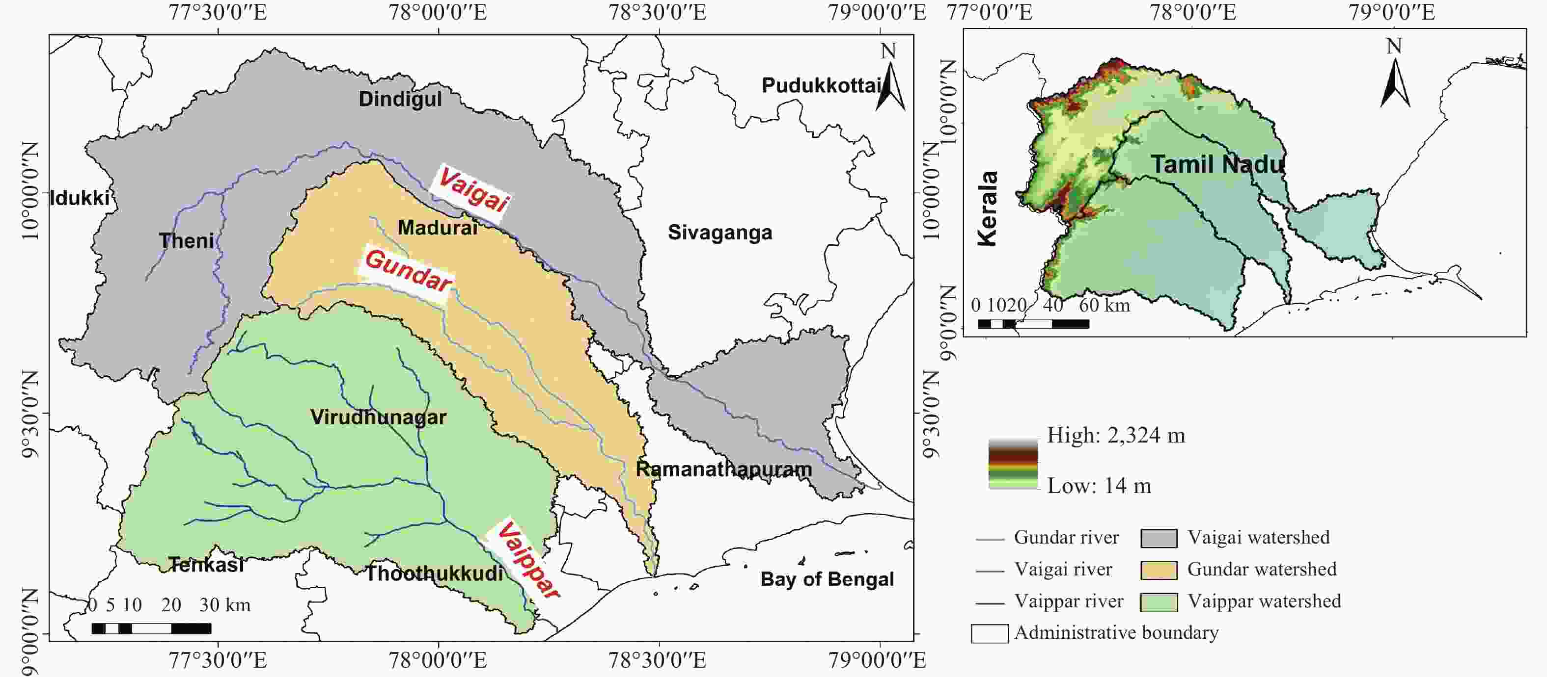
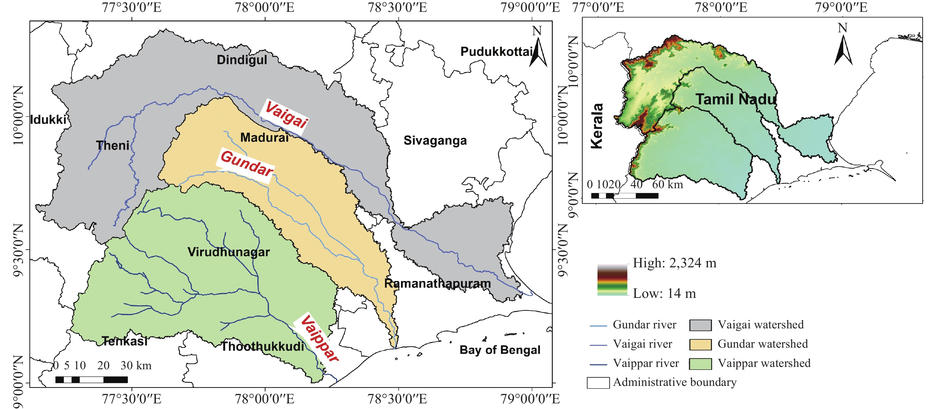
Figure 2. Location map of the VGV ephemeral rivers, watershed boundaries, elevation and administrative districts.
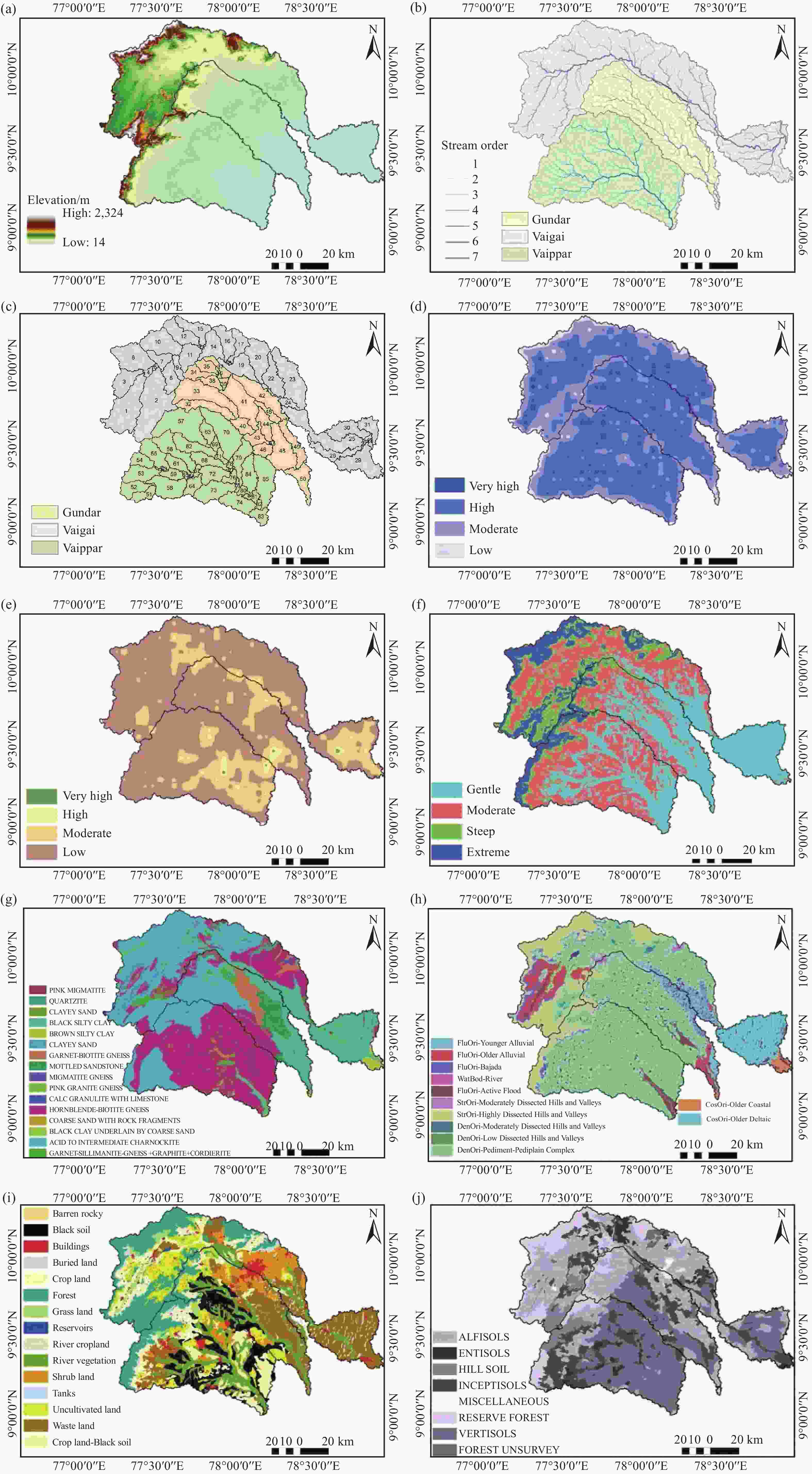
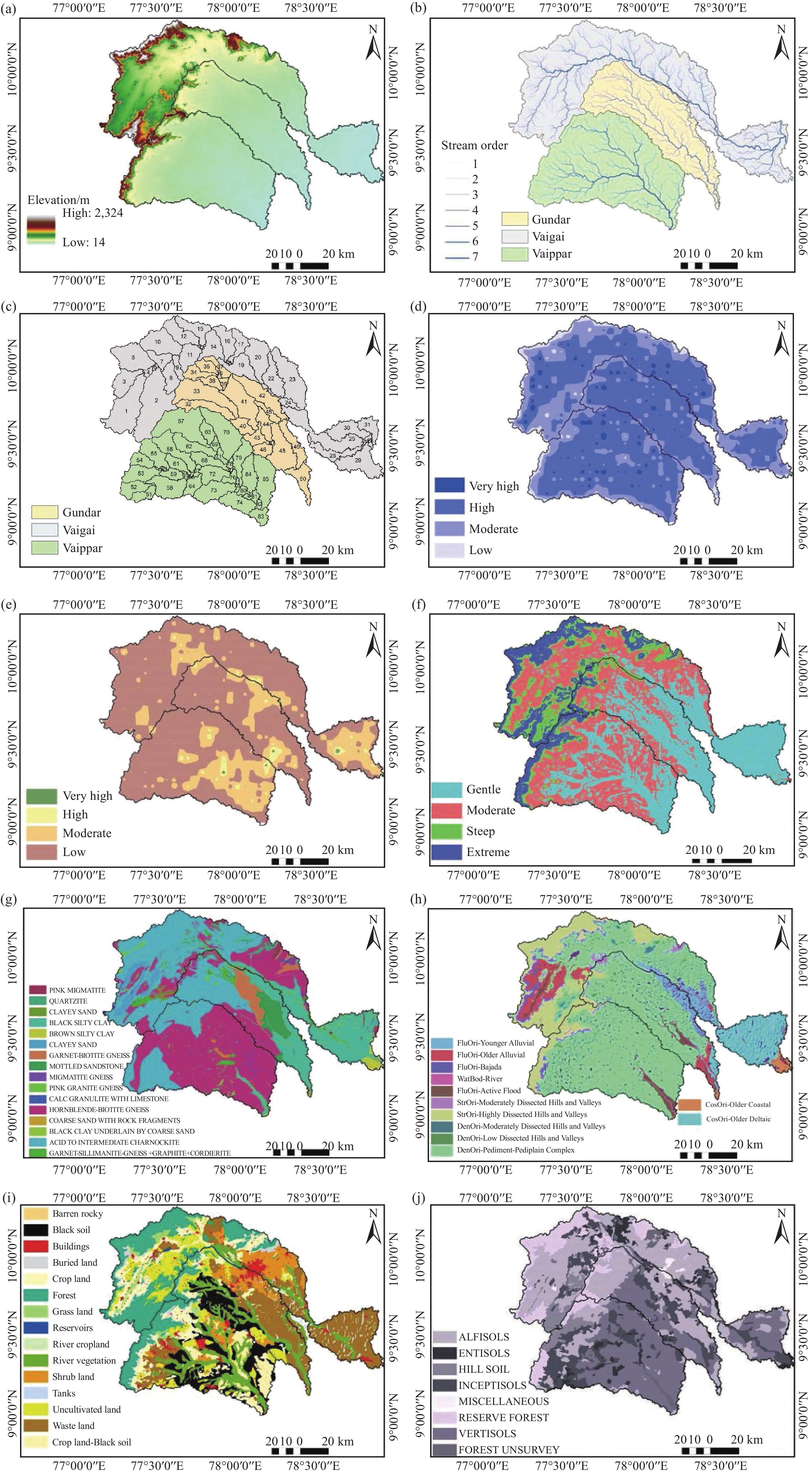
Figure 3. Mapping of ten thematic layers in the VGV watersheds
Notes: Topography (a); Stream orders (b); Sub-watersheds (c); Drainage density (d); Lineament density (e); Slope (f); Lithology with the stratigraphy formation (g); Geomorphology (h); LULC (i); NBSS-LUP soil classification (j)
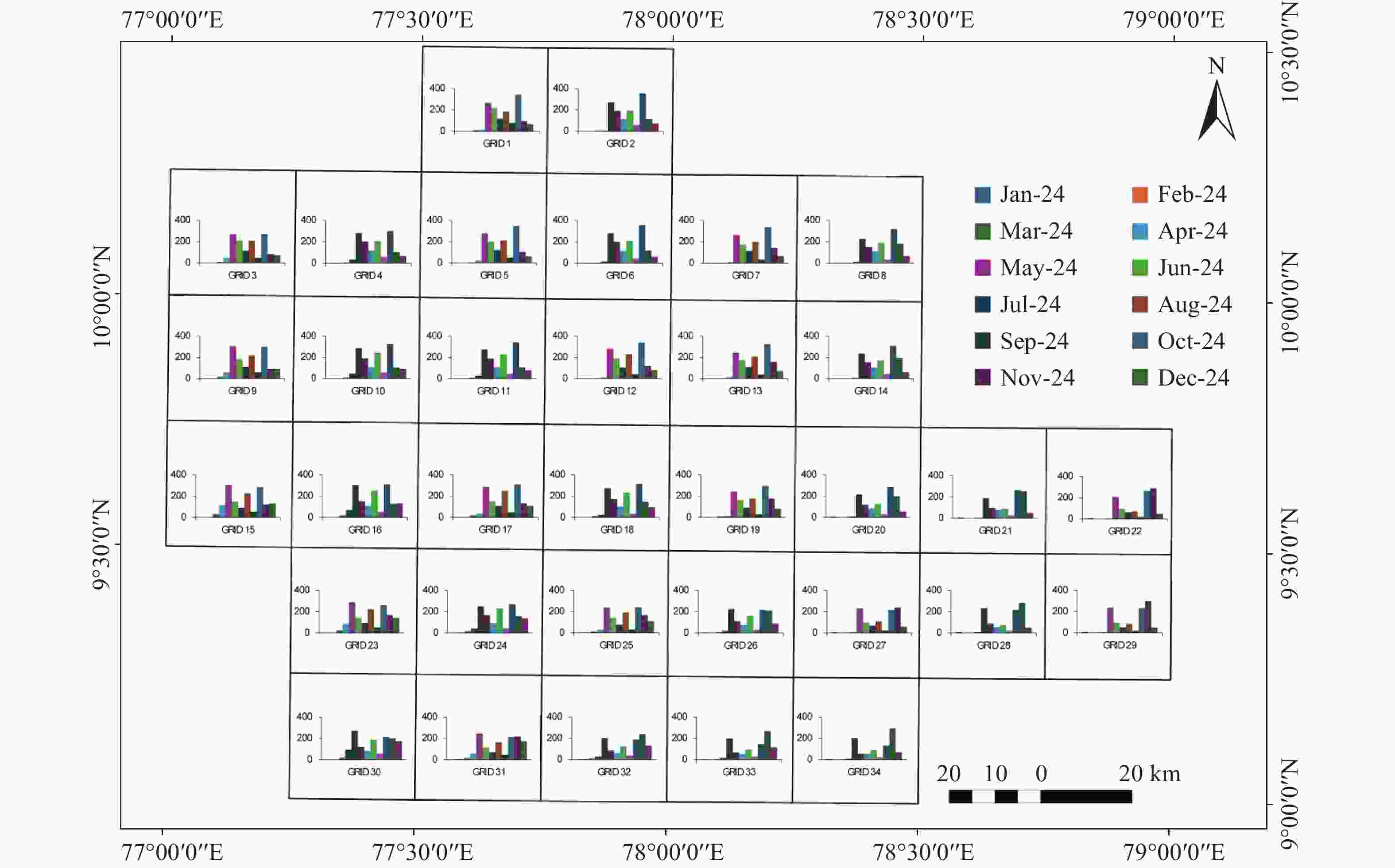
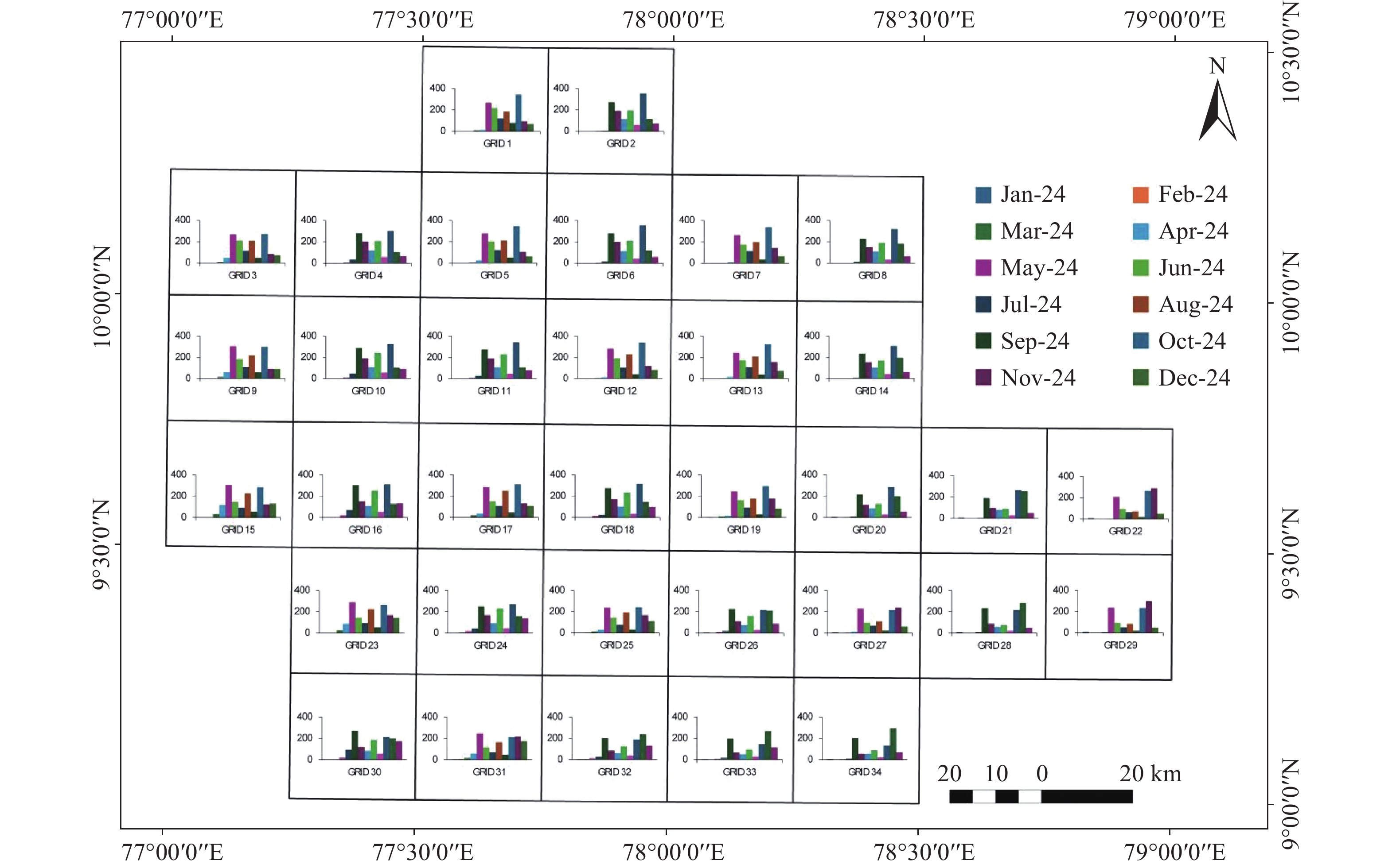
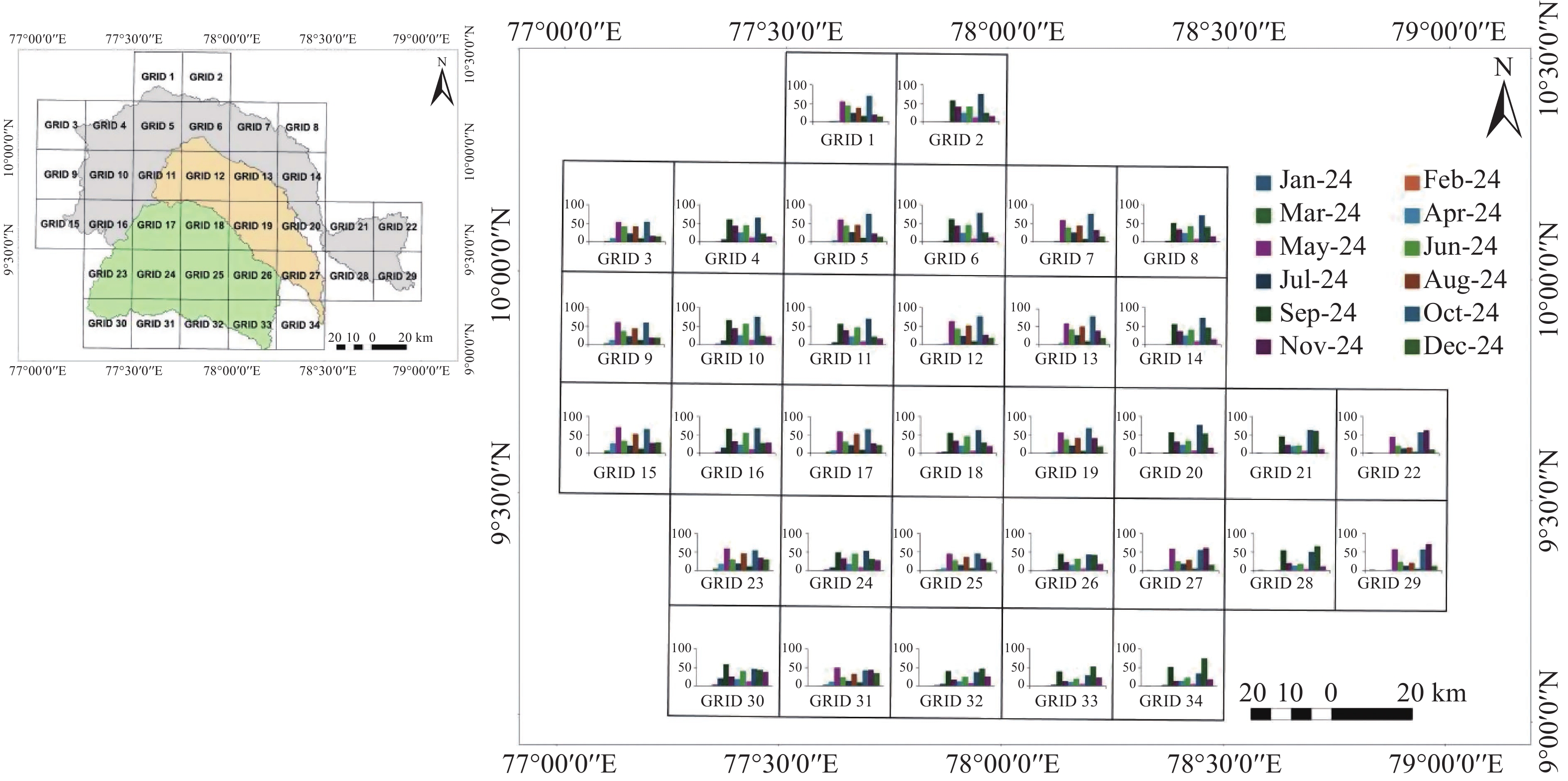
Figure 4. Spatial distribution of PERSIANN gridded rainfall across 34 grid cells covering the study area. In each grid cell, the y-axis represents the rainfall distribution, and the x-axis represents the month, with colours from January 2024 to December 2024
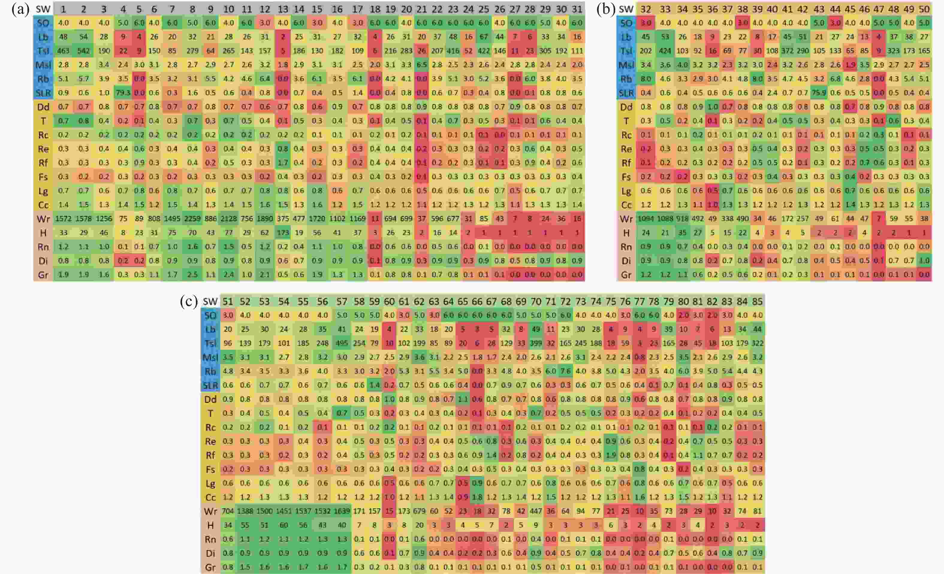
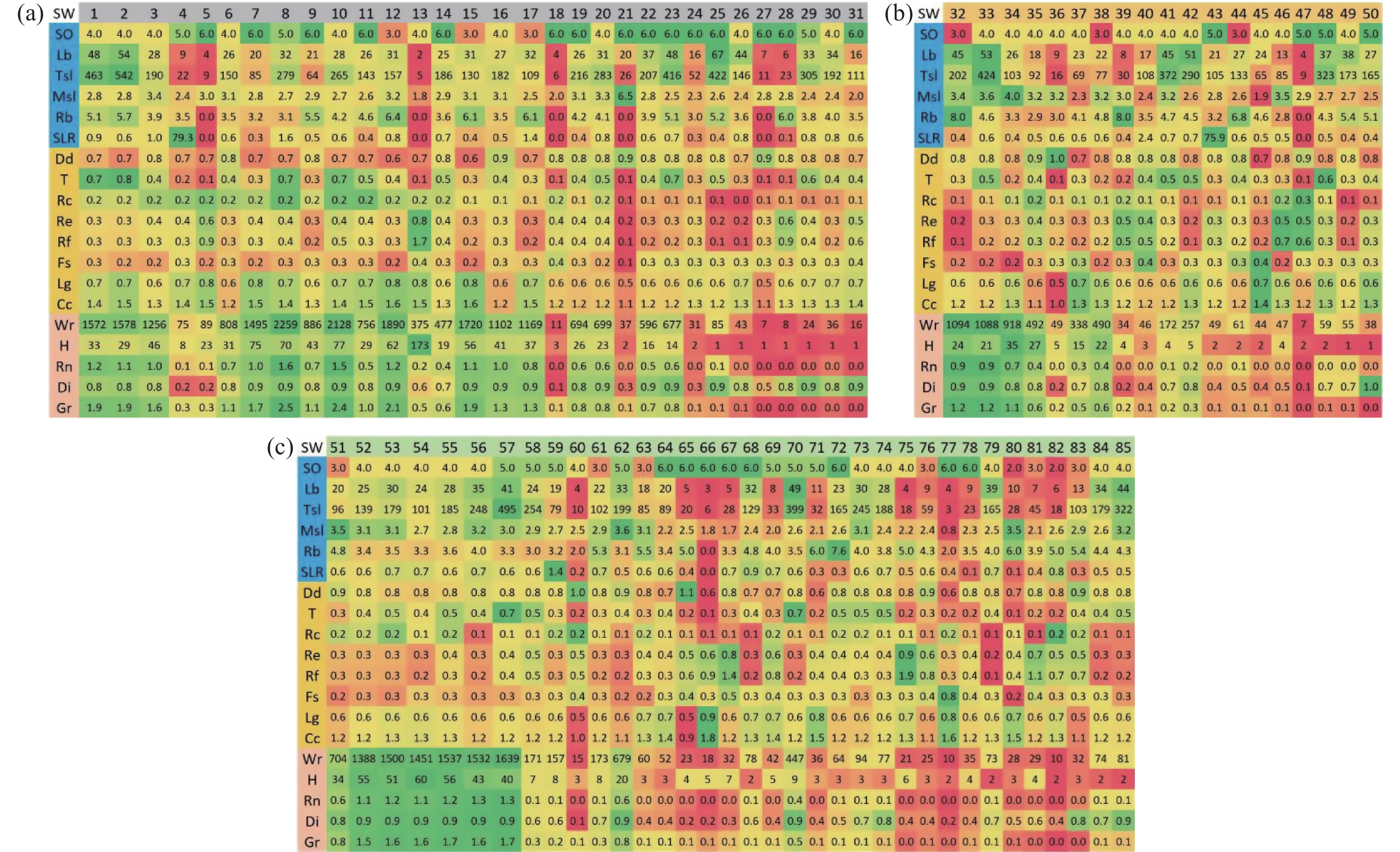
Figure 5. Heatmap of morphometric characteristics for VGV sub-watersheds, shaded from dark green (high values) to dark red (low values)
Notes: (a) Sub-watersheds 1–31 of Vaigai; (b) sub-watersheds 32–50 of Gundar; (c) sub-watersheds 51–85 of Vaippar. Rows represent: Linear characteristics (blue, rows 2–7), Areal characteristics (orange, rows 8–15), and Relief characteristics (sand, rows 16–20)
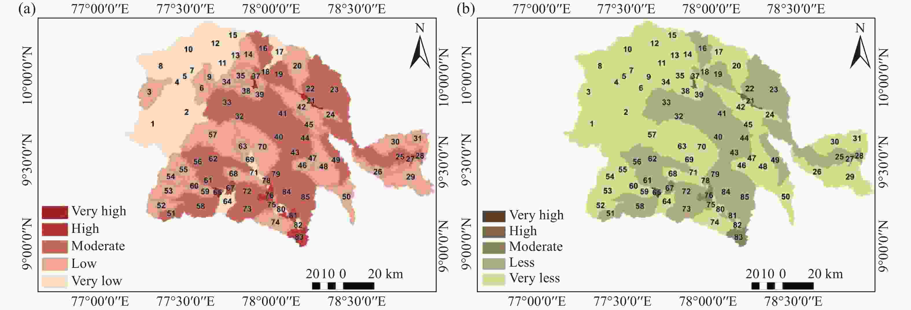
Figure 6. Spatial distribution of runoff rate (a) and sediment rate (b) across ephemeral VGV sub-watersheds
Notes: Sub-watersheds 1–31 of Vaigai, 32–50 of Gundar, and 51–85 of Vaippar
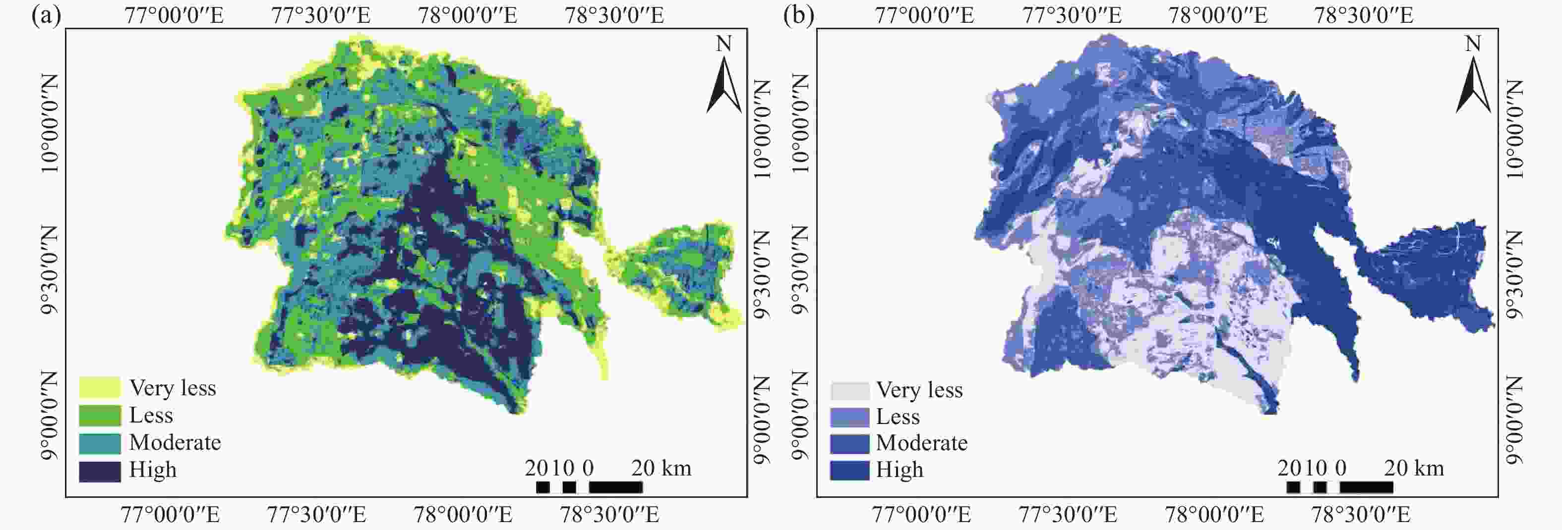
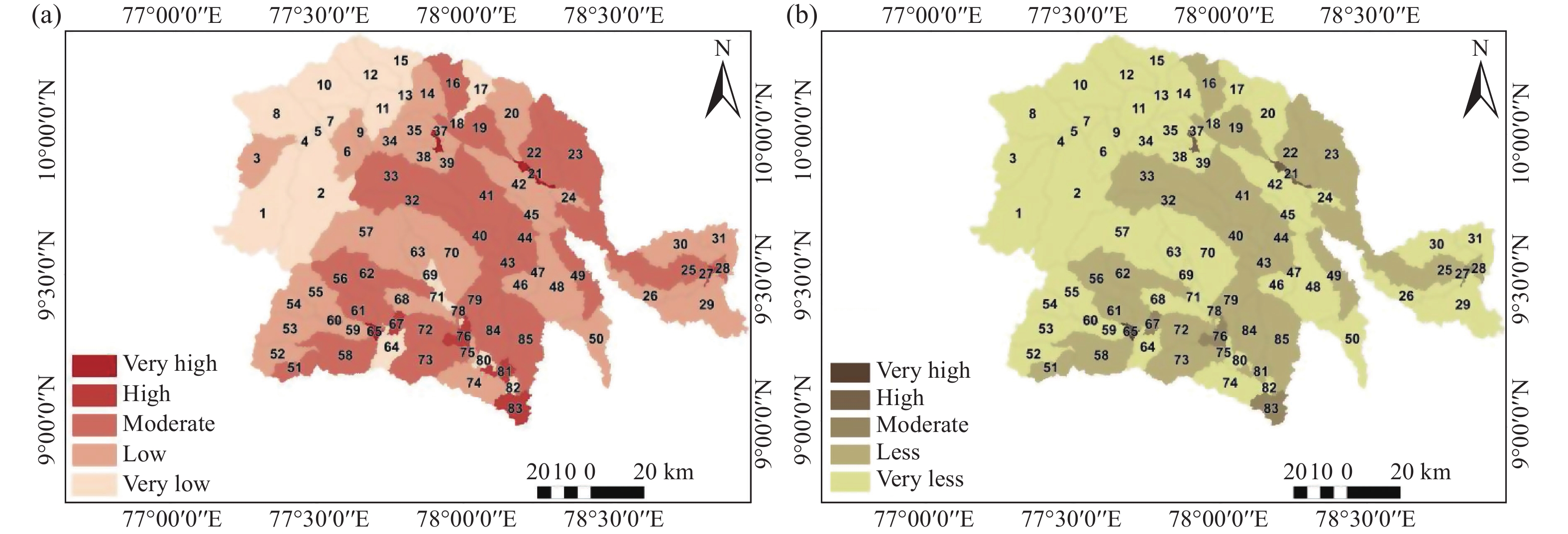
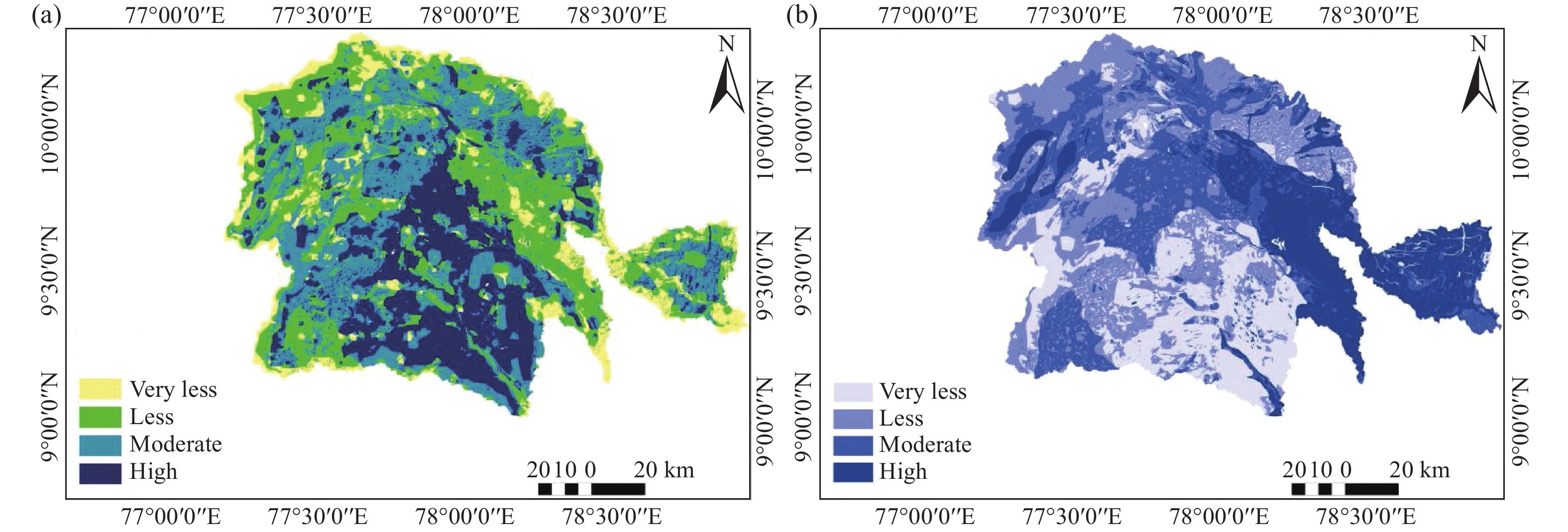
Figure 7. Spatial distribution of surface and subsurface water potential indices across the VGV watershed: SWPI (a) and GPI (b), each classifiedinto four categories (very low, low, moderate, and high)
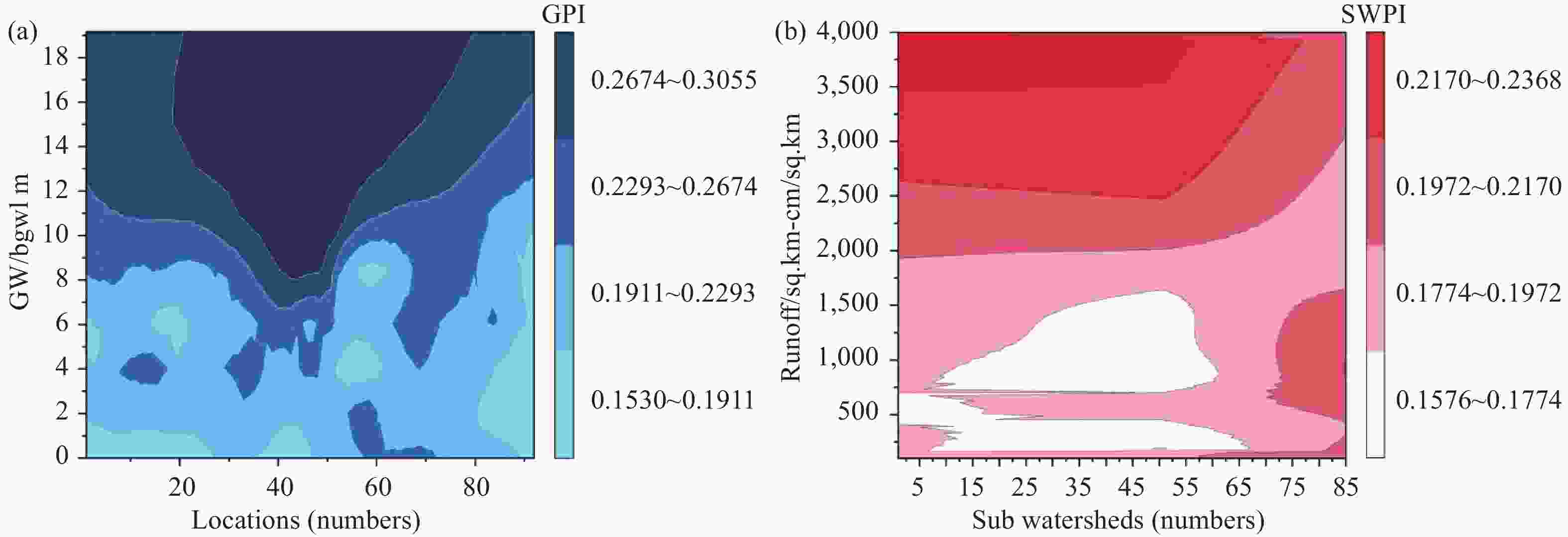
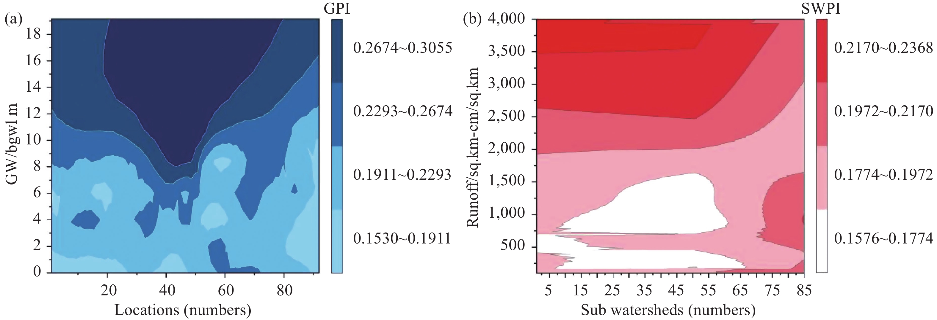
Figure 8. Spatial validation of surface and subsurface water potential indices. Contour plots of (a) SWPI versus runoff for 85 sub-watersheds and (b) GPI versus groundwater level for 93 groundwater stations
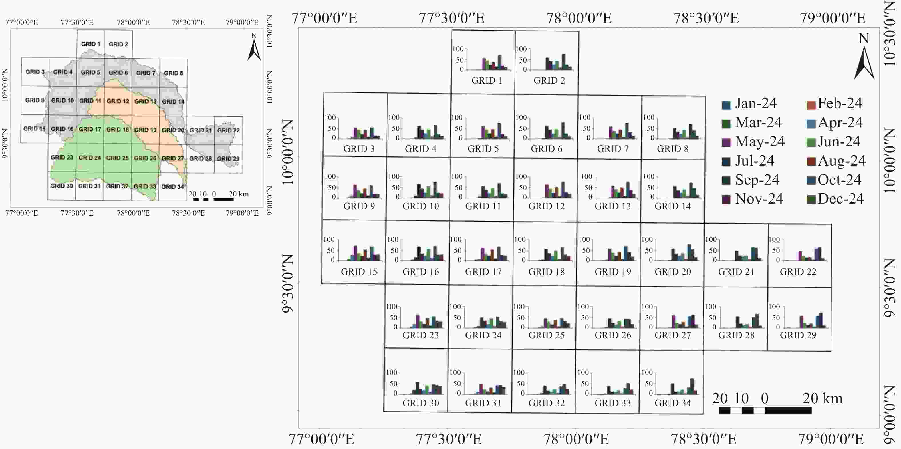
Figure 9. Probable runoff depth (mm) per PERSIANN grid cell from January 2024 to December 2024. The y-axis represents the runoff depth (mm), and the x-axis represents the 12 months, with each month denoted by a distinct colour
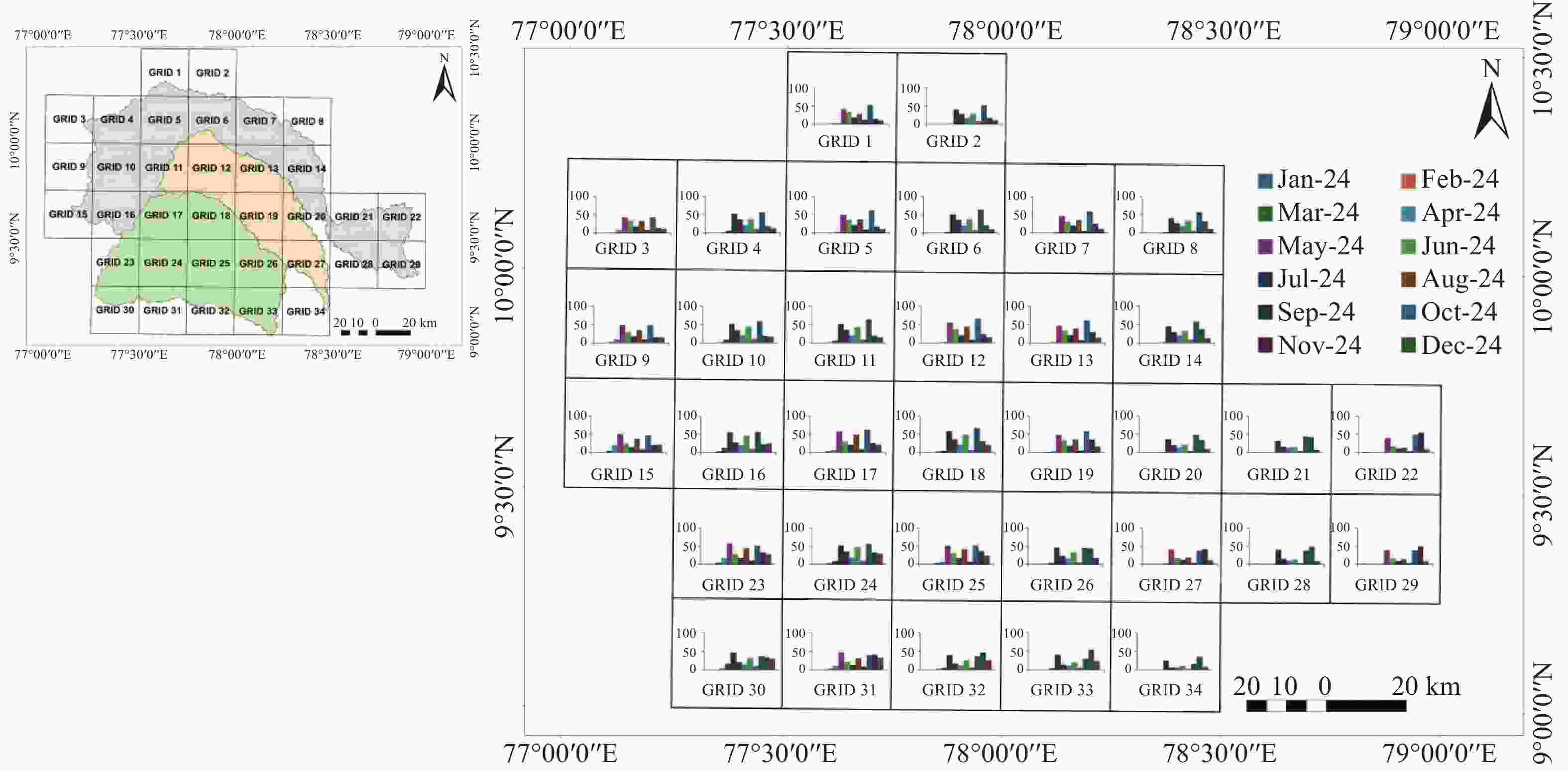
Figure 10. Probable groundwater recharge (mm) per PERSIANN grid cell from January 2024 to December 2024. The y-axis represents groundwater recharge (mm), and the x-axis represents the 12 months, with each month denoted by a distinct colour
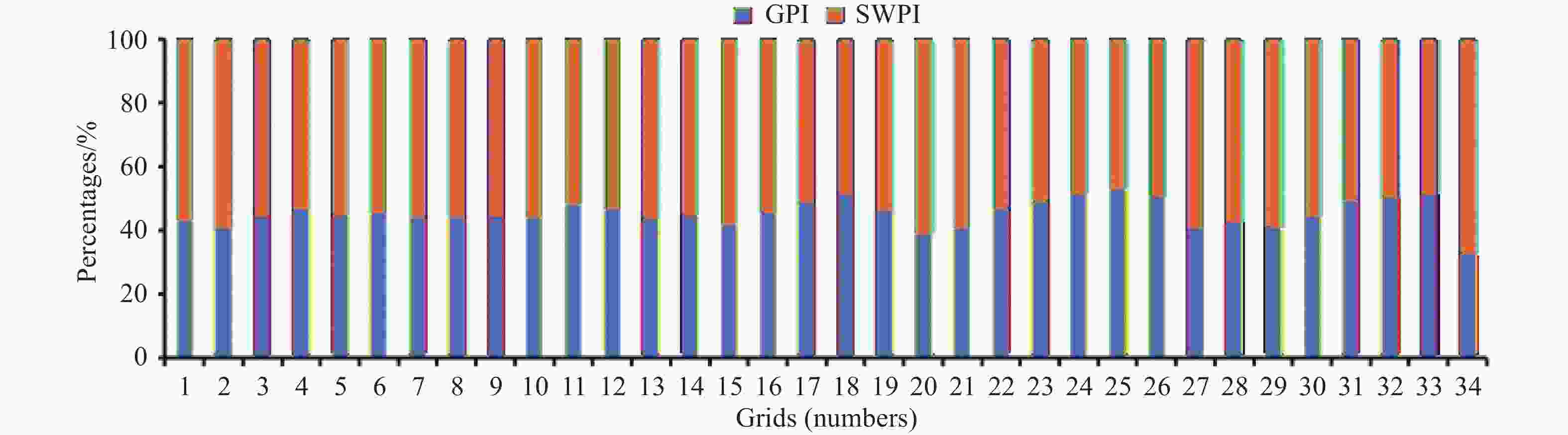
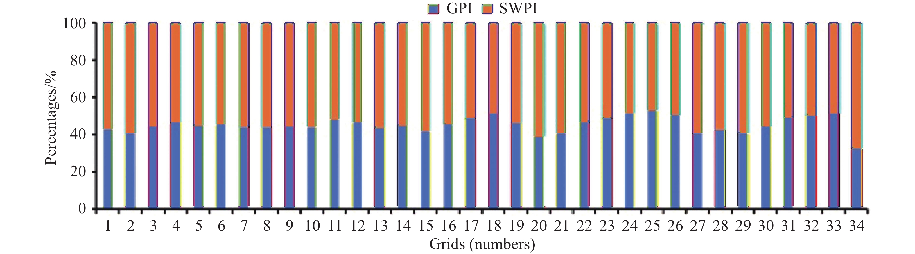
Figure 11. Annual percentage distribution of runoff and groundwater recharge across the 34 PERSIANN grid cells for 2024.
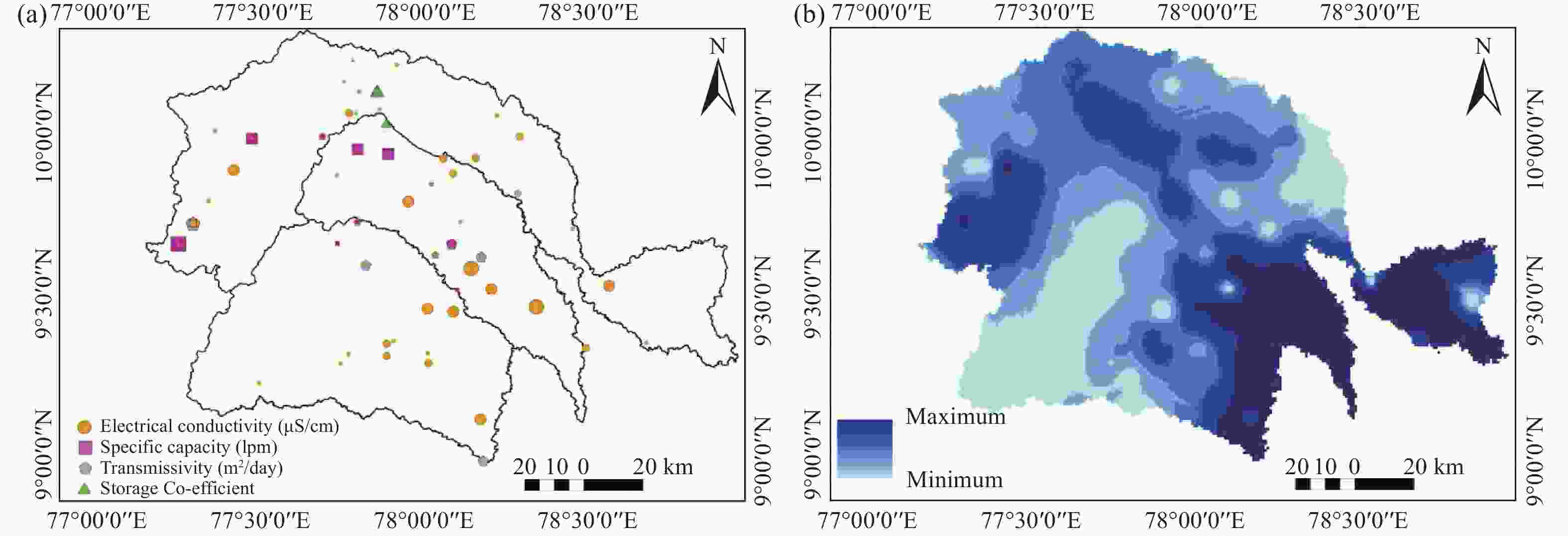
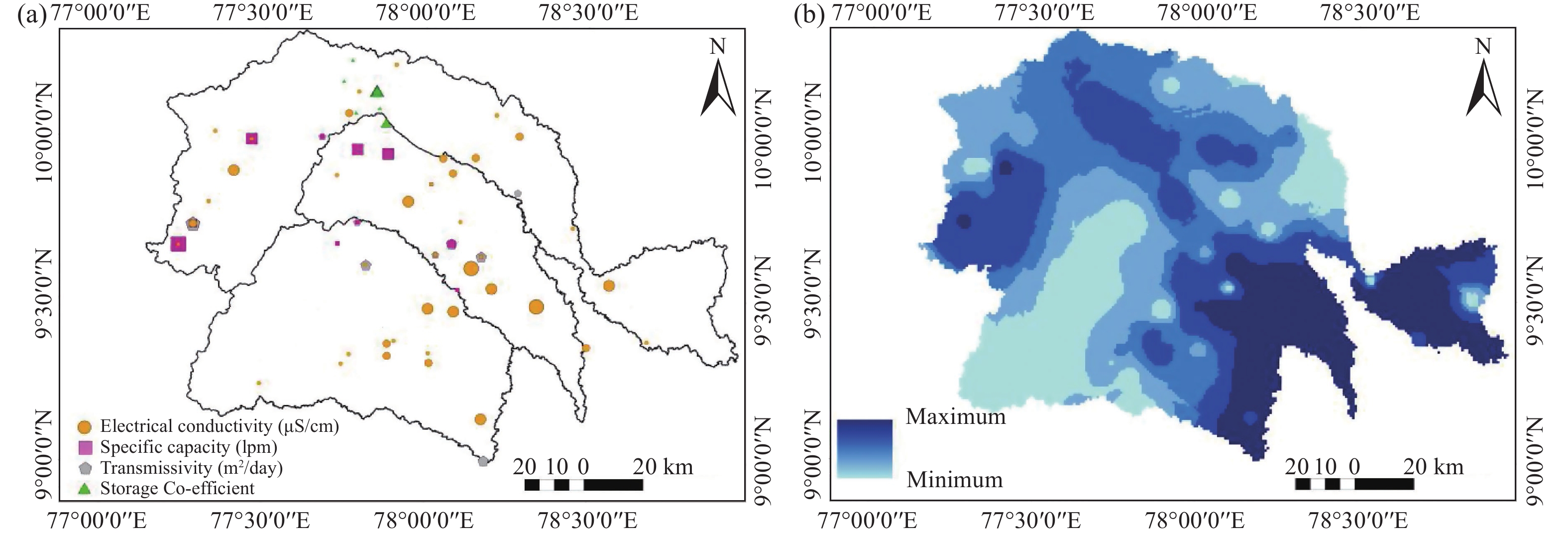
Figure 12. Conceptual hydrogeological model showing (a) spatial distribution of hydrogeological parameters and (b) derived groundwater potential gradient across the VGV watersheds
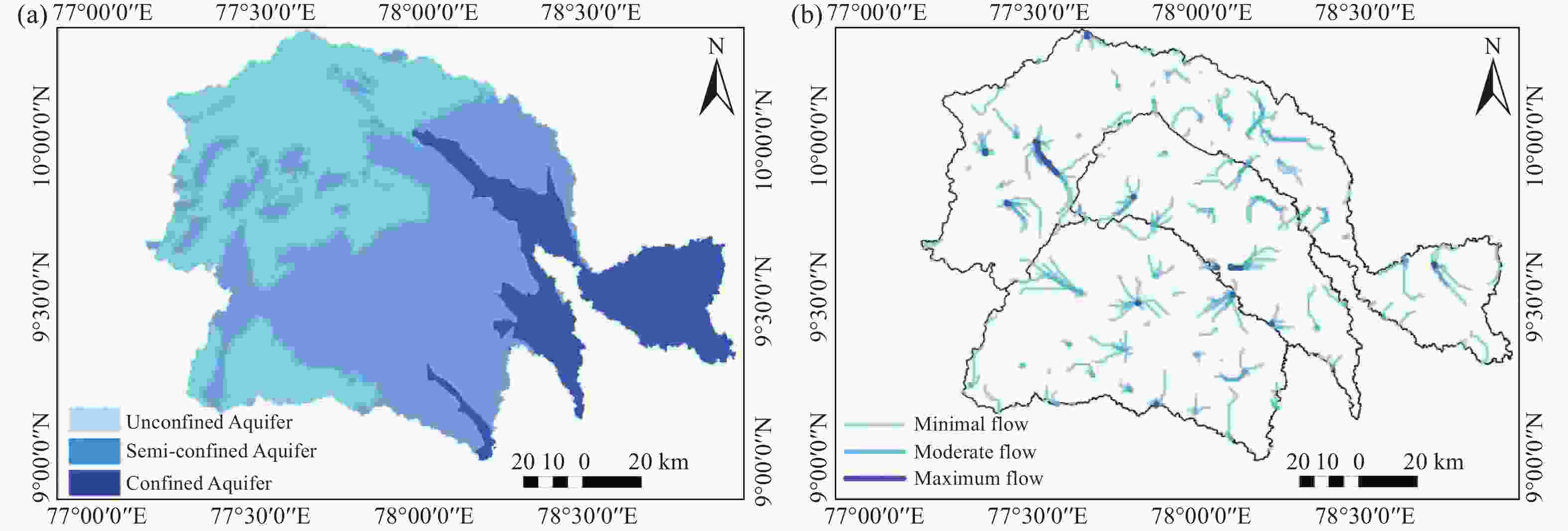
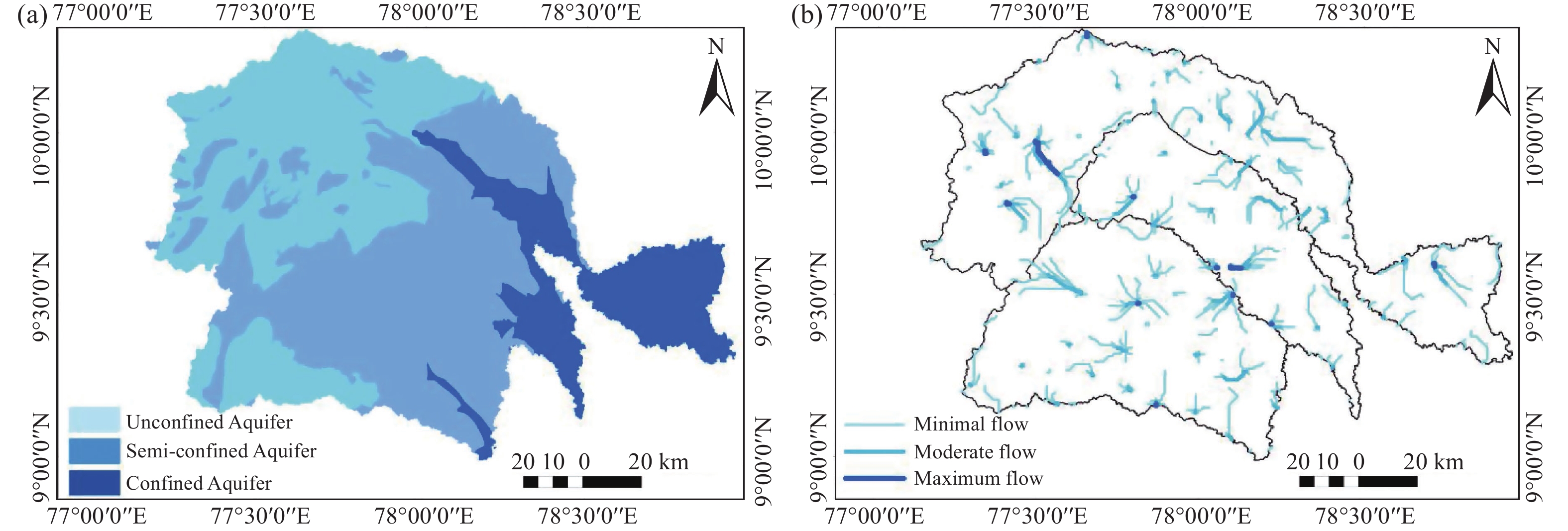
Figure 13. Conceptual hydrogeological model
Notes: (a) Aquifer system classification and (b) groundwater flow network across the VGV watersheds
Table 1. Data description of thematic layers
Primary/secondary data Source Spatial Resolution/Map scale Temporal Topography (Elevation) Aster-GDEM v3 30 m 2013 Slope Streams orders Sub-watersheds Lineament Hillshade from Aster-GDEM v3 Drainage density Streams orders Lineament density Lineament LULC Landsat 8/9 30 m 2023 (April) Soil ICAR-NBSS/LUP 1∶200,000 - Lithology Bhukosh Geological Survey of India 1∶250,000 - Geomorphology 1∶250,000 -  下载: 导出CSV
Table 2. Description of morphometric parameters with their formulae
Morphometric parameters Formulae References Linear Stream order (O) Aster-GDEM v3 (1 to 7) (Strahler, 1952) Total stream length (Tsl) Tsl = ∑(sln) (Horton, 1945) Watershed length (Lb) Longest stream path of the sub-watershed Mean stream length (Msl) Msl = Tslo/No (Strahler, 1952) Mean Bifurcation ratio (Rb) Rb = ∑(No/No+ 1) (Horton, 1932) Stream length ratio (SLR) SLR = ∑(Tslo/Tslo-1) (Horton, 1945) Areal Drainage density (Dd) Dd = Tsl/A (Horton, 1932) Drainage texture (T) T = N/P (Horton, 1932) Circulatory ratio (Rc) Rc = 4π A/P2 (Potter, 1957) Elongation ratio (Re) Re = 2√(A/π)/Lb (Schumm, 1956) Form factor (Rf) Rf = A/Lb2 (Horton, 1932) Stream frequency (Fs) Fs = N/A (Horton, 1945) Length of overland flow (Lg) Lg = 1/2Dd (Horton, 1932) Constant Channel Maintenance (Cc) Lg = 1/Dd (Schumm, 1956) Relief Watershed relief (Wr) Diff. of max. and min. relief of the watershed (Melton, 1957) Relief ratio (H) H = Wr/Lb (Schumm, 1956) Ruggedness number (Rn) Rn = Wr.Dd (Schumm, 1956) Dissection index (Di) Di = Wr/Ar (Schumm, 1956) Gradient Ratio (Gr) Gr=maximum relief -minimum relief/Lb (Melton, 1957)
下载: 导出CSV
Major terms Aster-GDEM v3 Advanced Spaceborne Thermal Emission and Reflection Radiometer Global Digital Elevation Model Version 3 AHP Analytical Hierarchy Process GIS Geographic Information System GSI Geological Survey of India GPI Groundwater Potential Index LULC Land Use/Land Cover MCDM Multi-Criteria Decision-Making NBSS- LUP National Bureau of Soil Survey-Land Use Planning PERSIANN Precipitation Estimation from Remotely Sensed Information using Artificial Neural Networks ROC Receiver Operating Characteristic SWAT Soil and Water Assessment Tool SWPI Surface Water Potential Index VGV Vaigai, Gundar, and Vaippar Notations Cc Constant Channel Maintenance Dd Drainage density Di Dissection index Fs Stream frequency Gr Gradient Ratio H Relief ratio Lb Watershed length Lg Length of overland flow Msl Mean stream length O Stream order Rb Mean Bifurcation ratio Rc Circulatory ratio Re Elongation ratio Rf Form factor Rn Ruggedness number SLR Stream length ratio T Drainage texture Tsl Total stream length Wr Watershed relief CR Consistency Ratio Ci Consistency Index Ri Random Index NR Normalized Weight GM Geometric Mean FM Fuzzy Mean Matrix FNR Fuzzy Normalized Weight WNR Overall Normalized Weight Index Greek letter λ eigenvalues of thematic data Subscripts n number of thematic classes f Fuzzy sets I Index for Consistency Index and Random Index
下载: 导出CSV
-
Abrams M, Yamaguchi Y, Crippen R. 2022. Aster Global Dem (Gdem) Version 3. The international archives of the photogrammetry, remote sensing and spatial information sciences - ISPRS archives, 43(B4-2022): 593–598. DOI: 10.5194/isprs-archives-XLIII-B4-2022-593-2022. Ahmed A, Srikanth R. 2023. Application of geospatial techniques and the MCDM Method to optimize interlinking of rivers in India. Journal of the Indian Society of Remote Sensing, 51(4): 849−863. DOI: 10.1007/s12524-023-01672-6. Aravinthasamy P, Karunanidhi D, Subramani T, et al. 2020. Geochemical evaluation of fluoride contamination in groundwater from Shanmuganadhi River basin, South India: Implication on human health. Environmental Geochemistry and Health, 42(7): 1937–1963. Available on https://doi.org/10.1007/s10653-019-00452-x Babu KJ, Sreekumar S, Aslam A. 2016. Implication of drainage basin parameters of a tropical river basin of South India. Applied Water Science, 6(1): 67−75. DOI: 10.1007/s13201-014-0212-8. Bajpai M, Gaur S, Kumar R, et al. 2023. Suitable sites for groundwater development: A capture map-based approach integrated with weighted overlay analysis. Aqua Water Infrastructure, Ecosystems and Society, 72(7): 1184−1197. DOI: 10.2166/aqua.2023.011. Barman J, VLH Zuali F, Bindajam AA, et al. 2024. Detection of groundwater conditioning factors in a hilly environment. Applied Water Science, 14(4): 1−19. DOI: 10.1007/s13201-024-02139-w. Bayode S, Mogaji KA, Egbeyemi O. 2024. Modeling of geophysical derived parameters for groundwater potential zonation using GIS-based multi-criteria conceptual model. Applied Water Science, 14(2): 1−26. DOI: 10.1007/s13201-023-02056-4. Bennett G. 2024. Analysis of methods used to validate remote sensing and GIS-based groundwater potential maps in the last two decades: A review. Geosystems and Geoenvironment, 3(1): 100245. DOI: 10.1016/j.geogeo.2023.100245. Bharath A, Kumar KK, Maddamsetty R, et al. 2021. Drainage morphometry based sub-watershed prioritization of Kalinadi basin using geospatial technology. Environmental Challenges, 5: 100277. DOI: 10.1016/j.envc.2021.100277. Bouizrou I, Bouadila A, Aqnouy M, et al. 2023. Assessment of remotely sensed precipitation products for climatic and hydrological studies in arid to semi-arid data-scarce region, central-western Morocco. Remote Sensing Applications: Society and Environment, 30: 100976. DOI: 10.1016/j.rsase.2023.100976. Chen W, Zhu D, Liu, H. et al. 2009. Land-air interaction over arid/semi-arid areas in China and its impact on the east Asian summer monsoon. Part I: Calibration of the land surface model (BATS) using multicriteria methods. Advances in Atmospheric Sciences, 26(6): 1088−1098. DOI: 10.1007/s00376-009-8187-3. Dahal K, Sharma S, Shakya A, et al. 2023. Identification of groundwater potential zones in data-scarce mountainous region using explainable machine learning. Journal of Hydrology, 627(PB): 130417. DOI: 10.1016/j.jhydrol.2023.130417. Devaraj D, Selvabala B. 2009. Real-coded genetic algorithm and fuzzy logic approach for real-time tuning of proportional-integral-derivative controller in automatic voltage regulator system. IET Generation, Transmission and Distribution, 3(7): 641−649. DOI: 10.1049/iet-gtd.2008.0287. Dey A, Remesan R, Kumar R. 2023. Blue and green water re-distribution dependency on precipitation datasets for a tropical Indian River basin. Journal of Hydrology: Regional Studies, 46: 101361. DOI: 10.1016/j.ejrh.2023.101361. Elewa HH, Zelenakova M, Nosair AM. 2021. Integration of the analytical hierarchy process and gis spatial distribution model to determine the possibility of runoff water harvesting in dry regions: Wadi watir in sinai as a case study. Water (Switzerland), 13(6): 804. DOI: 10.3390/w13060804. Enemark T, Peeters LJM, Mallants D, et al. 2019. Hydrogeological conceptual model building and testing: A review. Journal of Hydrology, 569: 310−329. DOI: 10.1016/j.jhydrol.2018.12.007. Gebre SL, Cattrysse D, Van Orshoven J. 2021. Multi-criteria decision-making methods to address water allocation problems: A systematic review. Water (Switzerland), 13(2): 1−28. DOI: 10.3390/w13020125. Ghosh A, Bera B. 2024. Potentialities and development of groundwater resources applying machine learning models in the extended section of Manbhum-Singhbhum Plateau, India. HydroResearch, 7: 1−14. DOI: 10.1016/j.hydres.2023.11.002. Halder S, Roy MB, Roy PK. 2020. Analysis of groundwater level trend and groundwater drought using Standard Groundwater Level Index: A case study of an eastern river basin of West Bengal, India. SN Applied Sciences, 2(3): 125. DOI: 10.1007/s42452-020-2302-6. Hamidy N, Alipur H, Nasab SNH, et al. 2016. Spatial evaluation of appropriate areas to collect rundoff using Analytic Hierarchy Process (AHP) and Geographical Information System (GIS) (case study: The catchment "Kasef" in Bardaskan). Modeling Earth Systems and Environment, 2(4): 1−11. DOI: 10.1007/s40808-016-0230-7. Horton RE. 1932. Drainage-basin characteristics. Eos, Transactions American Geophysical Union, 13(1): 350−361. DOI: 10.1029/TR013i001p00350. Horton RE. 1945. Erosional development of streams and their drainage basins; hydrophysical approach to quantitative morphology. GSA Bulletin, 56(3): 275−370. DOI: 10.1130/0016-7606(1945)56[275:EDOSAT]2.0.CO;2. Ishola KS, Fatoyinbo AA, Hamid-Mosaku AI, et al. 2023. Groundwater potential mapping in hard rock terrain using remote sensing, geospatial and aeromagnetic data. Geosystems and Geoenvironment, 2(1): 100107. DOI: 10.1016/j.geogeo.2022.100107. Jose CS, Das DC. 1982. Geomorphic prediction models for sediment production rate and intensive priorities of watersheds in Mayurakshi catchment. Proceedings of International Symposium on Hydrological Aspects of Mountainous Watershed, School of Hydrology, University of Roorkee, 1: 15–23. Kaliraj S, Chandrasekar N, Magesh NS. 2014. Identification of potential groundwater recharge zones in Vaigai upper basin, Tamil Nadu, using GIS-based analytical hierarchical process (AHP) technique. Arabian Journal of Geosciences, 7(4): 1385−1401. DOI: 10.1007/s12517-013-0849-x. Kalura P, Pandey A, Chowdary VM, et al. 2025. A TOPSIS-based multicriteria assessment of hydrologic model calibration using satellite-derived evapotranspiration and streamflow data. Hydrological Processes, 39(7): e70191. DOI: 10.1002/hyp.70191. Kannan PRG, Panchabikesan VAR, Kamaraj S, et al. 2024. Drought assessment using multivariate indices in the sub-basins of the Vaippar River Basin, Tamil Nadu, India. Paddy and Water Environment, 22(1): 61−83. DOI: 10.1007/s10333-023-00953-7. Khasanov K. 2020. Evaluation of ASTER DEM and SRTM DEM data for determining the area and volume of the water reservoir. IOP Conference Series: Materials Science and Engineering, 883(1): 012063. DOI: 10.1088/1757-899X/883/1/012063. Kumar R, Dwivedi SB, Gaur S. 2021. A comparative study of machine learning and Fuzzy-AHP technique to groundwater potential mapping in the data-scarce region. Computers and Geosciences, 155(2021): 104855. DOI: 10.1016/j.cageo.2021.104855. Latrubesse EM, Stevaux JC, Sinha R. 2005. Tropical rivers. Geomorphology, 70(3-4): 187−206. DOI: 10.1016/j.geomorph.2005.02.005. Mahala A. 2020. The significance of morphometric analysis to understand the hydrological and morphological characteristics in two different morpho-climatic settings. Applied Water Science, 10(1): 1−16. DOI: 10.1007/s13201-019-1118-2. Masroor M, Sajjad H, Kumar P, et al. 2023. Novel ensemble machine learning modeling approach for groundwater potential mapping in parbhani district of Maharashtra, India. Water (Switzerland), 15(3): 419. DOI: 10.3390/w15030419. Melton A. 1957. An analysis of the relations among elements of climate, surface properties, and geomorphology. In Office of Naval Research Technical Report No. 11 (Issue 11). Available on https://doi.org/https://scispace.com/pdf/an-analysis-of-the-relations-among-elements-of-climate-2gf00mdv30.pdf Mohanty RK, Chandran M, Paramasivam K. 2023. Delineating the hydrostratigraphic units, hydrogeological boundaries and disposition of the multilayered aquifer system of Gundar river basin, Southern India through groundwater exploration techniques. Geointerface, 2(2): 45−52. Available on https://doi.org/https://cehesh.in/contents/Dec2023vol2/GEOINTERFACE_RajKishoreMohanty.pdf Muthiah M, Sivarajan S, Madasamy N, et al. 2024. Analyzing rainfall trends using statistical methods across Vaippar Basin, Tamil Nadu, India: A Comprehensive Study. Sustainability (Switzerland), 16(5): 1957. DOI: 10.3390/su16051957. Nguyen P, Shearer EJ, Tran H, et al. 2019. The CHRS data portal, an easily accessible public repository for PERSIANN global satellite precipitation data. Scientific Data, 6: 1−10. DOI: 10.1038/sdata.2018.296. Pandi D, Kothandaraman S, Kumarasamy MV, et al. 2022. Assessment of land use and land cover dynamics using geospatial techniques. Polish Journal of Environmental Studies, 31(3): 2779−2786. DOI: 10.15244/pjoes/141810. Pandi D, Kothandaraman S, Kuppusamy M. 2020. Delineation of potential groundwater zones based on multicriteria decision making technique. Journal of Groundwater Science and Engineering, 8(2): 180−194. DOI: 10.19637/j.cnki.2305-7068.2020.02.009. Pandi D, Kothandaraman S, Kuppusamy M. 2023. Simulation of water balance components using SWAT model at sub catchment level. Sustainability (Switzerland), 15(2): 1438. DOI: 10.3390/su15021438. Peach D, Taylor A. 2024. The development of a hydrogeological conceptual model of groundwater and surface water flows in the Silala River Basin. Wiley Interdisciplinary Reviews: Water, 11(1): 1−25. DOI: 10.1002/wat2.1676. Pholkern K, Saraphirom P, Cloutier V, et al. 2019. Use of alternative hydrogeological conceptual models to assess the potential impact of climate change on groundwater sustainable yield in Central Huai Luang Basin, Northeast Thailand. Water (Switzerland), 11(2): 241. DOI: 10.3390/w11020241. Pothiraj P, Rajagopalan B. 2013. A GIS and remote sensing based evaluation of groundwater potential zones in a hard rock terrain of Vaigai sub-basin, India. Arabian Journal of Geosciences, 6(7): 2391−2407. DOI: 10.1007/s12517-011-0512-3. Potter PE. 1957. A quantitative geomorphic study of drainage basin characteristics in the Clinch Mountain Area, Virginia and Tennessee. V. C. Miller. The Journal of Geology, 65(1): 112−113. DOI: 10.1086/626413. Prasad P, Loveson VJ, Kotha M, et al. 2020. Application of machine learning techniques in groundwater potential mapping along the west coast of India. GIScience and Remote Sensing, 57(6): 735−752. DOI: 10.1080/15481603.2020.1794104. Pratik D, Jishnu S. 2020. Identification and validation of potential flood hazard area using GIS-based multi-criteria analysis and satellite data-derived water index. Journal of Flood Risk Management, 13(1): e12620. DOI: 10.1111/jfr3.12620. Raj S, Rawat KS, Singh SK, et al. 2024. Groundwater potential zones identification and validation in Peninsular India. Geology, Ecology, and Landscapes, 8(1): 86−100. DOI: 10.1080/24749508.2022.2097375. Ramkumar M, Nagarajan R, Juni KJ, et al. 2024. Tectono-climatic and depositional environmental controls on the Neolithic habitation sites, Vaigai River Basin, Southern India. Geological Journal, 59(4): 1199−1218. DOI: 10.1002/gj.4919. Rana VK, Suryanarayana TMV. 2020. GIS-based multi criteria decision making method to identify potential runoff storage zones within watershed. Annals of GIS, 26(2): 149−168. DOI: 10.1080/19475683.2020.1733083. Rautela KS, Kumar M, Khajuria V, et al. 2022. Comparative geomorphometric approach to understand the hydrological behaviour and identification of the Erosion prone areas of a coastal watershed using RS and GIS tools. Discover Water, 2(1): 1−16. DOI: 10.1007/s43832-021-00009-z. Rihani JF, Maxwell RM, Chow FK. 2010. Coupling groundwater and land surface processes: Idealized simulations to identify effects of terrain and subsurface heterogeneity on land surface energy fluxes. Water Resources Research, 46(12): 1−14. DOI: 10.1029/2010WR009111. Sankar K. 2002. Evaluation of groundwater potential zones using remote sensing data in upper Vaigai river basin, Tamil Nadu, India. Journal of the Indian Society of Remote Sensing, 30(3): 119−129. DOI: 10.1007/BF02990644. Sarkar SK, Rudra RR, Talukdar S, et al. 2024. Future groundwater potential mapping using machine learning algorithms and climate change scenarios in Bangladesh. Scientific Reports, 14(1): 1−17. DOI: 10.1038/s41598-024-60560-2. Schumm SA. 1956. Evolution of drainage systems and slopes in badlands at perth amboy, new jersey. GSA Bulletin, 67(5): 597−646. DOI: 10.1130/0016-7606(1956)67[597:EODSAS]2.0.CO;2. Şen Z. 2023. Hydrological methodology evolution for runoff estimations at Ungauged Sites. Water (Switzerland), 15(4): 1−16. DOI: 10.3390/w15040702. Shandu ID, Atif I. 2023. An integration of geospatial modelling and machine learning techniques for mapping groundwater potential zones in Nelson Mandela Bay, South Africa. Water (Switzerland), 15(19): 3447. DOI: 10.3390/w15193447. Shekar PR, Mathew A. 2023. Delineation of groundwater potential zones and identification of artificial recharge sites in the Kinnerasani Watershed, India, using remote sensing-GIS, AHP, and Fuzzy-AHP techniques. Aqua Water Infrastructure, Ecosystems and Society, 72(8): 1474−1498. DOI: 10.2166/aqua.2023.052. Shekar PR, Mathew A, Abdo HG, et al. 2023. Prioritizing sub-watersheds for soil erosion using geospatial techniques based on morphometric and hypsometric analysis: A case study of the Indian Wyra River basin. Applied Water Science, 13(7): 1−26. DOI: 10.1007/s13201-023-01963-w. Singh MC, Satpute S, Prasad V. 2023. Remote sensing and GIS-based watershed prioritization for land and water conservation planning and management. Water Science and Technology, 88(1): 233−265. DOI: 10.2166/wst.2023.207. Sofi MS, Rautela KS, Bhat SU, et al. 2021. Application of geomorphometric approach for the estimation of hydro-sedimentological flows and cation weathering rate: Towards understanding the sustainable land use policy for the Sindh Basin, Kashmir Himalaya. Water, Air, and Soil Pollution, 232(7). DOI: 10.1007/s11270-021-05217-w. Song G, Huang JT, Ning BH, et al. 2021. Effects of groundwater level on vegetation in the arid area of western China. China Geology, 4(3): 527−535. DOI: 10.31035/cg2021062. Strahler AN. 1952. Dynamic basis of geomorphology. Geological Society of America Bulletin, 63(9): 923−938. DOI: 10.1130/0016-7606(1952)63[923:DBOG]2.0.CO;2. Sukumaran H, Sahoo SN. 2022. Error due to DEM sources in catchment area and river network using D8 algorithm. In Hydrological Modelling: Hydraulics, Water Resources and Coastal Engineering. Cham: Springer International Publishing: 259–269. DOI: 10.1007/978-3-030-81358-1_20. Suresh M, Sudhakar S, Tiwari KN, et al. 2004. Prioritization of watersheds using morphometric parameters and assessment of surface water potential using remote sensing. Journal of the Indian Society of Remote Sensing, 32(3): 249−259. DOI: 10.1007/BF03030885. Sutradhar S, Mondal P. 2023. Prioritization of watersheds based on morphometric assessment in relation to flood management: A case study of Ajay river basin, Eastern India. Watershed Ecology and the Environment, 5: 1−11. DOI: 10.1016/j.wsee.2022.11.011. Syvitski JPM, Cohen S, Kettner AJ, et al. 2014. How important and different are tropical rivers? — An overview. Geomorphology, 227: 5−17. DOI: 10.1016/j.geomorph.2014.02.029. Takahiro S, Ramasamy Duraiyappan P. 2011. The effects of expansion of private wells on rural livelihood in tank intensive watersheds: A case study in Upper Gundar River Basin, Tamil Nadu. Southeast Asian Studies, 49(1): 124−150. DOI: 10.20495/tak.49.1_124. Tigabu TB, Wagner PD, Narasimhan B, et al. 2023. Pitfalls in hydrologic model calibration in a data scarce environment with a strong seasonality: Experience from the Adyar catchment, India. Environmental Earth Sciences, 82(15): 1−17. DOI: 10.1007/s12665-023-11047-2. Tiwari A, Joshi SK, Tripathi SK, et al. 2021. Spatial pattern of groundwater recharge in Jhansi district in the Bundelkhand region, central India. Environment, Development and Sustainability, 23(12): 18618−18630. DOI: 10.1007/s10668-021-01405-0. Tran VN, Kim J. 2022. Robust and efficient uncertainty quantification for extreme events that deviate significantly from the training dataset using polynomial chaos-kriging. Journal of Hydrology, 609: 127716. DOI: 10.1016/j.jhydrol.2022.127716. Vahidnia MH, Alesheikh A, Alimohammadi A, et al. 2008. Fuzzy analytical hierarchy process in GIS application. The International Archives of the Photogrammetry, Remote Sensing and Spatial Information Sciences, 37(B2): 593–596. Available on https://doi.org/www.isprs.org/proceedings/xxxvii/congress/2_pdf/4_wg-ii-4/15.pdf Villalta Echeverria MDP, Viña Ortega AG, Larreta E, et al. 2022. Lineament extraction from digital terrain derivate model: A case study in the Girón–Santa Isabel Basin, South Ecuador. Remote Sensing, 14(21): 5400. DOI: 10.3390/rs14215400. Walega A, Amatya DM, Caldwell P, et al. 2020. Assessment of storm direct runoff and peak flow rates using improved SCS-CN models for selected forested watersheds in the Southeastern United States. Journal of Hydrology: Regional Studies, 27: 100645. DOI: 10.1016/j.ejrh.2019.100645. Wang WD, Straffelini E, Pijl A, et al. 2022. Sustainable water resource management in steep-slope agriculture. Geography and Sustainability, 3(3): 214−219. DOI: 10.1016/j.geosus.2022.07.001. Xu HL, Wang DQ, Deng ZD, et al. 2018. Assessment of shallow groundwater potential in the island based on GF-1 and DEM data by remote sensing. Hydrogeology and Engineering Geology, 45(6): 42−48. (in Chinese) DOI: 10.16030/j.cnki.issn.1000-3665.2018.06.07. Xu Z, Liu J, Wu Z, et al. 2024. Enhancing streamflow simulation accuracy in ungauged catchments via parameter calibration with triple collocation-based merged evapotranspiration and streamflow features. Journal of Hydrology, 639: 131627. DOI: 10.1016/j.jhydrol.2024.131627. Zabihi H, Alizadeh M, Wolf ID, et al. 2020. A GIS-based fuzzy-analytic hierarchy process (F-AHP) for ecotourism suitability decision making: A case study of Babol in Iran. Tourism Management Perspectives, 36: 100726. DOI: 10.1016/j.tmp.2020.100726. -


 点击查看大图
计量
- 文章访问数: 12
- HTML全文浏览量: 4
- PDF下载量: 0
- 被引次数: 0


