• ISSN 2305-7068
  • Indexed by ESCI CABI CAS
  • DOAJ Scopus GeoRef AJ CNKI
Advanced Search

2022 Vol. 10, No. 4

Display Method:
Analytical solutions for constant-rate test in bounded confined aquifers with non-Darcian effect
Yi-jie Zong, Li-hua Chen, Jian-jun Liu, Yue-hui Liu, Yong-xin Xu, Fu-wan Gan, Liang Xiao
2022, 10(4): 311-321. doi: 10.19637/j.cnki.2305-7068.2022.04.001
Abstract(841) FullText HTML (383) PDF(90)
Abstract:
This paper proposes a simplified analytical solution considering non-Darcian and wellbore storage effect to investigate the pumping flow in a confined aquifer with barrier and recharge boundaries. The mathematical modelling for the pumping-induced flow in aquifers with different boundaries is developed by employing image-well theory with the superposition principle, of which the non-Darcian effect is characterized by Izbash’s equation. The solutions are derived by Boltzmann and dimensionless transformations. Then, the non-Darcian effect and wellbore storage are especially investigated according to the proposed solution. The results show that the aquifer boundaries have non-negligible effects on pumping, and ignoring the wellbore storage can lead to an over-estimation of the drawdown in the first 10 minutes of pumping. The higher the degree of non-Darcian, the smaller the drawdown.
Evolution of the freeze-thaw cycles in the source region of the Yellow River under the influence of climate change and its hydrological effects
Liang Zhu, Ming-nan Yang, Jing-tao Liu, Yu-xi Zhang, Xi Chen, Bing Zhou
2022, 10(4): 322-334. doi: 10.19637/j.cnki.2305-7068.2022.04.002
Abstract(662) FullText HTML (286) PDF(70)
Abstract:
As an important water source and ecological barrier in the Yellow River Basin, the source region of the Yellow River (above the Huangheyan Hydrologic Station) presents a remarkable permafrost degradation trend due to climate change. Therefore, scientific understanding the effects of permafrost degradation on runoff variations is of great significance for the water resource and ecological protection in the Yellow River Basin. In this paper, we studied the mechanism and extent of the effect of degrading permafrost on surface flow in the source region of the Yellow River based on the monitoring data of temperature and moisture content of permafrost in 2013–2019 and the runoff data in 1960–2019. The following results have been found. From 2013 to 2019, the geotemperature of the monitoring sections at depths of 0–2.4 m increased by 0.16°C/a on average. With an increase in the thawing depth of the permafrost, the underground water storage space also increased, and the depth of water level above the frozen layer at the monitoring points decreased from above 1.2 m to 1.2–2 m. 64.7% of the average multiyear groundwater was recharged by runoff, in which meltwater from the permafrost accounted for 10.3%. Compared to 1960-1965, the runoff depth in the surface thawing period (from May to October) and the freezing period (from November to April) decreased by 1.5 mm and 1.2 mm, respectively during 1992–1997, accounting for 4.2% and 3.4% of the average annual runoff depth, respectively. Most specifically, the decrease in the runoff depth was primarily reflected in the decreased runoff from August to December. The permafrost degradation affects the runoff within a year by changing the runoff generation, concentration characteristics and the melt water quantity from permafrost, decreasing the runoff at the later stage of the permafrost thawing. However, the permafrost degradation has limited impacts on annual runoff and does not dominate the runoff changes in the source region of the Yellow River in the longterm.
Geoelectrical survey over perched aquifers in the northern part of Upper Sakarya River Basin, Türkiye
Ertekin Can, Ulugergerli Emin U
2022, 10(4): 335-352. doi: 10.19637/j.cnki.2305-7068.2022.04.003
Abstract(415) FullText HTML (149) PDF(66)
Abstract:
In this study, a groundwater exploration survey was conducted using the DC Resistivity (DCR) method in a hydrogeological setting containing a perched aquifer. DCR data were gathered and an electrical tomography section was recovered using conventional four-electrode instruments with a Schlumberger array and a two-dimensional (2D) inversion scheme. The proposed scheme was tested over a synthetic three-dimensional (3D) subsurface model before deploying it in a field situation. The proposed method indicated that gathering data with simple four-electrode instruments at stations along a line and 2D inversion of datasets at multiple stations can recover depth intervals of the studied aquifer in the hydrogeological setting even if it has a 3D structure. In this study, 2D inversion of parallel profiles formed a pseudo-3D volume of the subsurface resistivity structures and mapped out multiple resistive (>25 ohm·m) bodies at shallow (between 50–100 m) and deep sections (>150 m). In general, the proposed method is convenient to encounter geological units that have limited vertical and spatial extensions in any direction and presents resistivity contrast from groundwater-bearing geologic materials.
Effect of groundwater on the ecological water environment of typical inland lakes in the Inner Mongolian Plateau
Chu Yu, Li-jie Wu, Yi-long Zhang, Xiu-ya Wang, Zhan-chuan Wang, Zhou Zhang
2022, 10(4): 353-366. doi: 10.19637/j.cnki.2305-7068.2022.04.004
Abstract(396) FullText HTML (165) PDF(58)
Abstract:
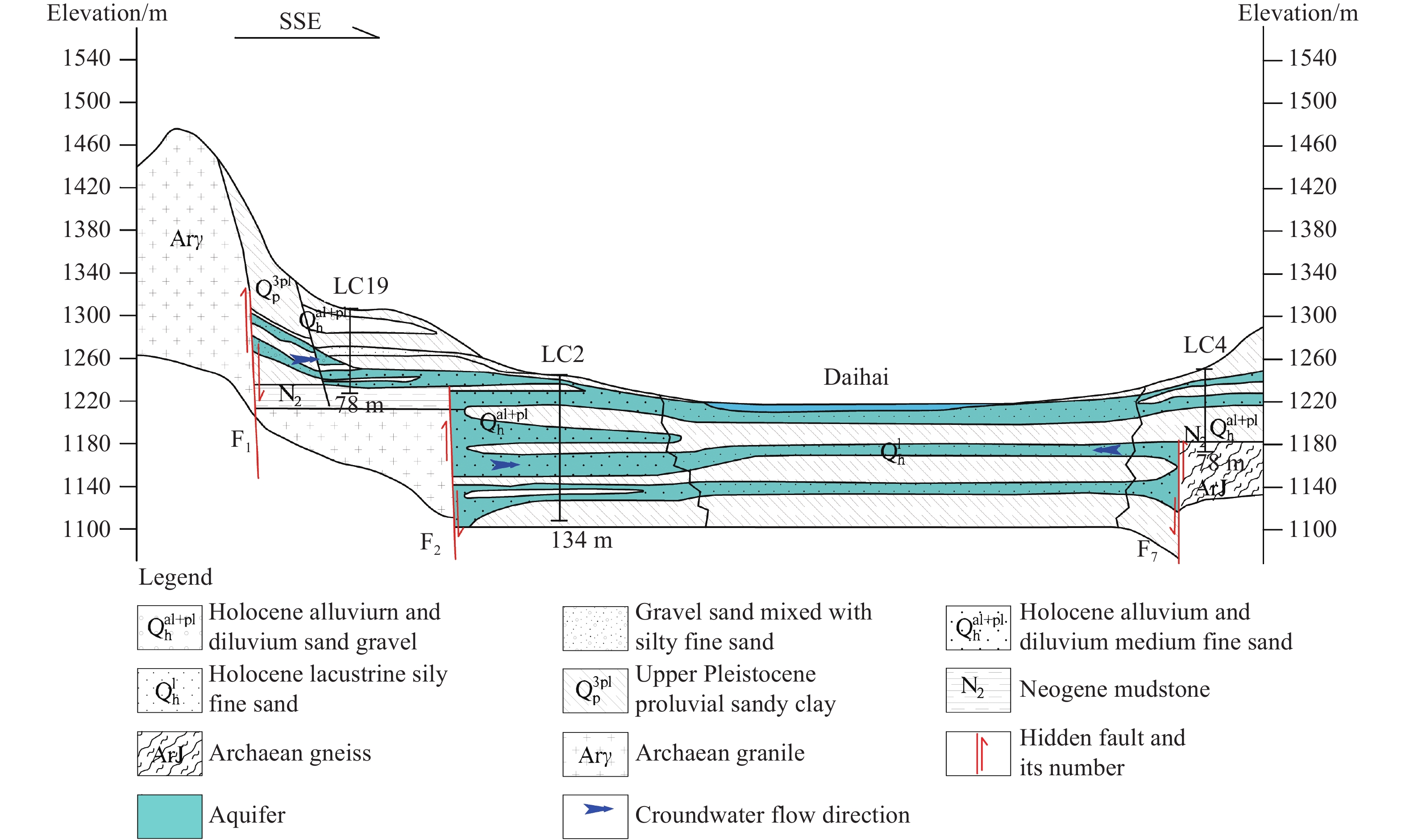
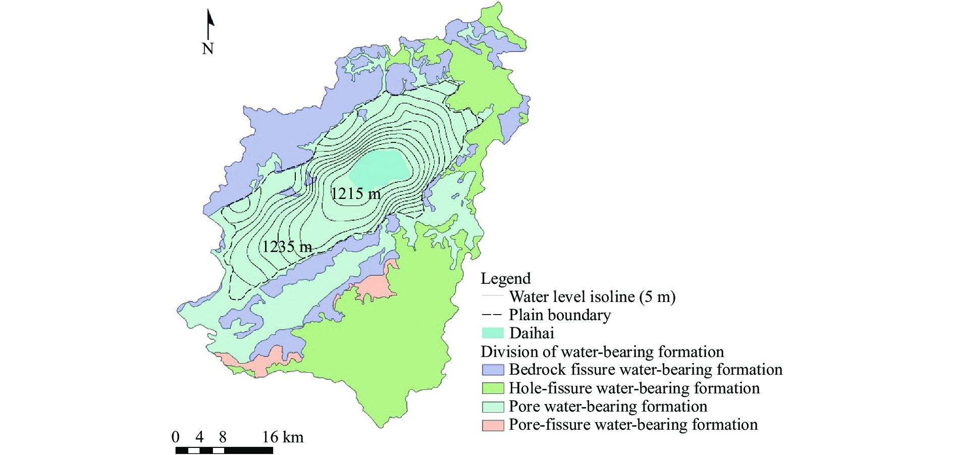
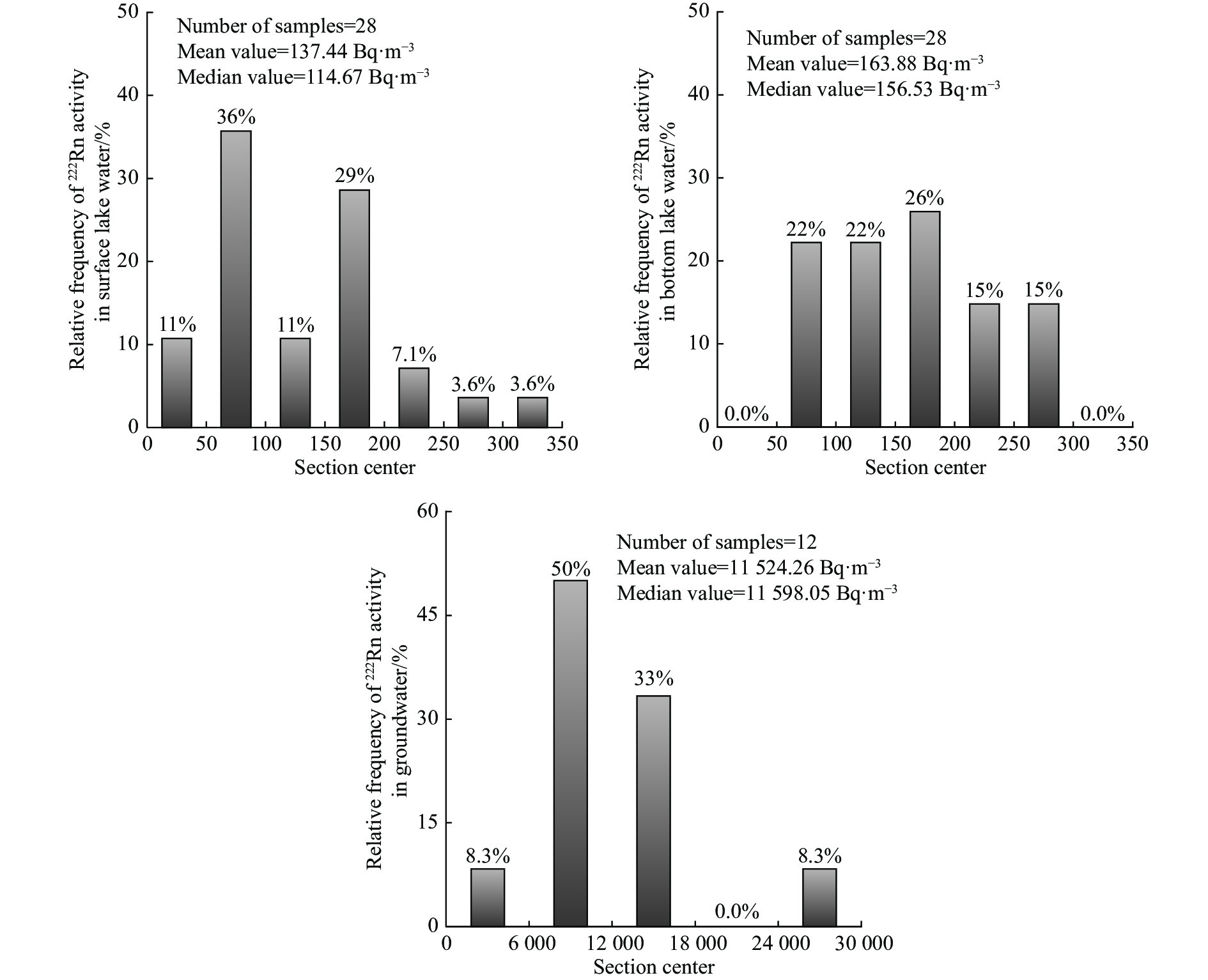
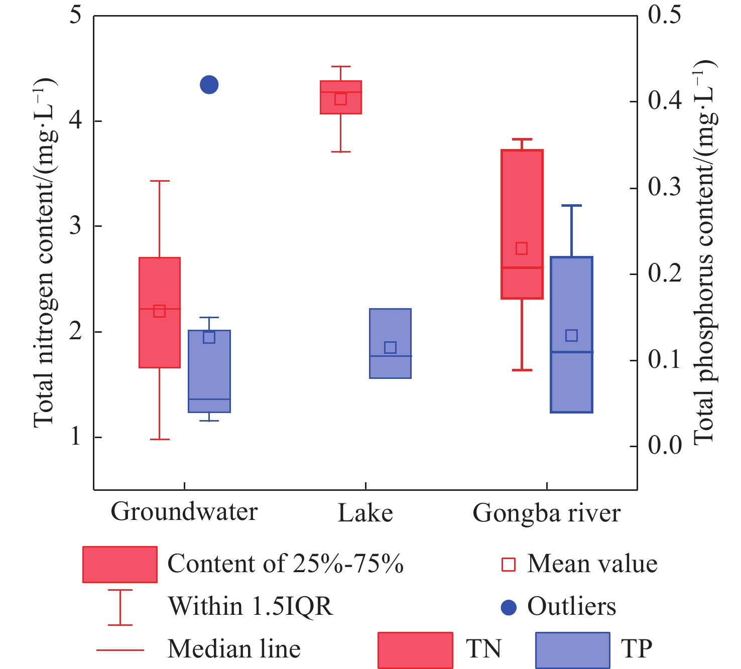
To explore the causes of the ecological environment deterioration of lakes in the Inner Mongolia Plateau, this study took a typical inland lake Daihai as an example, and investigated the groundwater recharge in the process of lake shrinkage and eutrophication. Using the radon isotope (222Rn) as the main means of investigation, the 222Rn mass balance equation was established to evaluate the groundwater recharge in Daihai. The spatial variability of 222Rn activity in lake water and groundwater, the contribution of groundwater recharge to lake water balance and its effect on nitrogen and phosphorus pollution in lake water were discussed. The analysis showed that, mainly controlled by the fault structure, the activity of 222Rn in groundwater north and south of Daihai is higher than that in the east and west, and the difference in lithology and hydraulic gradient may also be the influencing factors of this phenomenon. The 222Rn activity of the middle and southeast of the underlying lake is greater, indicating that the 222Rn flux of groundwater inflow is higher, and the runoff intensity is greater, which is the main groundwater recharge area for the lake. The estimated groundwater recharge in 2021 was 3 017×104 m3, which was 57% of the total recharge to the lake, or 1.6 times and 8.1 times that of precipitation and surface runoff. The TN and TP contents in Daihai have been rising continuously, and the average TN and TP concentrations in the lake water in 2021 were 4.21 mg·L−1 and 0.12 mg·L−1, respectively. The TN and TP contents entering the lake with groundwater recharge were 6.8 times and 8.7 times above those of runoff, accounting for 87% and 90% of the total input, respectively. The calculation results showed that groundwater is not only the main source of recharge for Daihai, but also the main source of exogenous nutrients. In recent years, the pressurized exploitation of groundwater in the basin is beneficial in increasing the groundwater recharge to the lake, reducing the water balance difference of the lake, and slowing down the shrinking degree of the lake surface. However, under the action of high evaporation, nitrogen and phosphorus brought by groundwater recharge would become more concentrated in the lake, leading to a continuous increase in the content of nutrients and degree of eutrophication. Therefore, the impact of changes in regional groundwater quantity and quality on Daihai is an important issue that needs further assessment.
Identification of groundwater potential in hard rock aquifer systems using Remote Sensing, GIS and Magnetic Survey in Veppanthattai, Perambalur, Tamilnadu
Muthamilselvan A Dr, Sekar Anamika, Ignatius Emmanuel
2022, 10(4): 367-380. doi: 10.19637/j.cnki.2305-7068.2022.04.005
Abstract(398) FullText HTML (145) PDF(57)
Abstract:
Water is an essential natural resource without which life wouldn’t exist. The study aims to identify groundwater potential areas in Vepapanthattai taluk of Perambalur district, Tamil Nadu, India, using analytic hierarchy process (AHP) model. Remote sensing and magnetic parameters have been used to determine the evaluation indicators for groundwater occurrence under the ArcGIS environment. Groundwater occurrence is linked to structural porosity and permeability over the predominantly hard rock terrain, making magnetic data more relevant for locating groundwater potential zones in the research area. NE-SW and NW-SE trending magnetic breaks derived from reduction to pole map are found to be more significant for groundwater exploration. The lineaments rose diagram indicates the general trend of the fracture to be in the NE-SW direction. Assigned normalised criteria weights acquired using the AHP model was used to reclassify the thematic layers. As a result, the taluk’s low, moderate, and high potential zones cover 25.08%, 25.68% and 49.24% of the study area, respectively. The high potential zones exhibit characteristics favourable for groundwater infiltration and storage, with factors as gentle slope of <3°, high lineament densities, magnetic breaks, magnetic low zones as indicative of dykes and cracks, lithology as colluvial deposits and land surface with dense vegetation. The depth of the fracture zones was estimated using power spectrum and Euler Deconvolution method. The groundwater potential mapping results were validated using groundwater level data measured from the wells, which indicated that the groundwater potential zoning results are consistent with the data derived from the real world.
Spatial distribution characteristics and main controlling factors of germanium in soil of northern Dabie Mountains, China
Qiu-yao Dong, Jiao Xiang, Chao Song, Pan Wang, Hao-tian Wen, Ming-jiang Yan
2022, 10(4): 381-392. doi: 10.19637/j.cnki.2305-7068.2022.04.006
Abstract(364) FullText HTML (147) PDF(50)
Abstract:
With the increasing application of germanium (Ge) elements in modern industry, military and medical health industries, especially with the growing demand for Ge-rich agricultural products, the study of Ge-rich soil has become particularly important, but the enrichment pattern and control factors of Ge-rich soil are still not well understood due to the high dispersion and high migration of Ge-rich soil. In this paper, 495 surface soil (0–20 cm) and 149 deep soil (150–200 cm) samples were collected from the northern foothills of Dabie Mountain using a double-layer grid layout, and the spatial distribution and enrichment characteristics of Ge were studied by high-resolution method, and the controlling factors affecting the distribution of Ge-rich soil was analyzed by geo-statistics and spatial analogy. The results show an average Ge content of 1.34 mg/kg for the surface and 1.36 mg/kg for the deep soil. In the assessment grade classification of surface and deep soil for Ge, the abundant and sub-abundant grades account for 37.97% and 31.70%, respectively, covering 752 km2 and 634 km2. Surface Ge-rich regions are distributed in concentrated strips in the north-central part of the studied region, and there is no clear pattern in the spatial distribution of deep soils. In the areas under study, such as Fenlukou, Dingji, and Jiangjiadian, the surface soil is very rich in Ge and has a high enrichment factor, which is valuable for agricultural development. In surface soils, river deposits and shallow metamorphic rock parent materials have the highest content of Ge, while in deep soils, the highest content has been found in the parent material of moderately acidic rock. Both surface and deep soils have the highest Ge content in purple paddy soils and plain areas. The source of Ge in the soils of the study area is most influenced by the lithology of the soil-forming parent material, while the distribution of Ge in the surface soils is jointly influenced by pH, SiO2, TFe2O3, and Al2O3 in the soil. This study has implications for understanding the enrichment pattern of Ge in soil and its controlling factors as well as for the development of Ge-rich agricultural products.
Stable chlorine isotopic signatures and fractionation mechanism of groundwater in Anyang, China
Xiao-xia Tong, Rong Gan, Shu-qian Gu, Xing-le Sun, Kai-tuo Huang, Xiao-feng Yan
2022, 10(4): 393-404. doi: 10.19637/j.cnki.2305-7068.2022.04.007
Abstract(300) FullText HTML (105) PDF(31)
Abstract:
The present work provides an online Bench II-IRMS technique for the measurement of stable chlorine isotope ratio, which is used to measure the δ37Cl of 38 groundwater samples from the Karst and Quaternary aquifers in Anyang area. The regional distribution and signature of δ37Cl value are characterized on the base of isotopic data. The results suggest that the δ37Cl value of Quaternary groundwater decreases with increasing Cl concentration, and has no correlation with δ18O and δD values, but closely correlates with the depth to water table. The fractionation mechanism of the chlorine isotope is expounded according to the type of groundwater. The δ37Cl value of karst water is generally positive, which is relevant to the dissolution of evaporite (gypsum mine), and may be caused by the mixing of groundwater and precipitation. The groundwater of Quaternary unconfined aquifer is mainly recharged by precipitation, and the δ37Cl value of groundwater is generally negative. The δ37Cl value of groundwater in Quaternary confined aquifer is more negative with increasing the depth to water level and elevated Cl concentration, which is possible to result from the isotope fractionation of ion filtration. The groundwater with inorganic pollutants in Quaternary unconfined aquifer has generally a positive δ37Cl value.
Tracing runoff components in the headwater area of Heihe River by isotopes and hydrochemistry
Han Zhang, Zong-yu Chen, Chang-yuan Tang
2022, 10(4): 405-412. doi: 10.19637/j.cnki.2305-7068.2022.04.008
Abstract(347) FullText HTML (130) PDF(45)
Abstract:
Since water resources of the Heihe River Basin are primarily in the form of surface runoff in the Qilian Mountains, identifying its sources and components is essential for researchers to understand water cycling and transformation in the basin. It will help to properly exploit water resources, and contribute to ecological environment construction. The paper uses the isotope data of hydrogen and oxygen in water and hydrochemistry data collected at a high altitude to trace the sources of surface runoff in Heihe River in rainy season and uses the three-component mixing model to estimate the contribution of each component to runoff. Results indicate that surface water consists of precipitation, melt water and groundwater, with precipitation being the primary component and contributing to 59%–64% of runoff. Melt water and groundwater account for 15%–25% and 12%–22%, respectively. Precipitation accounts for 60%, groundwater for 22% and glacial melt water for 18% of the outflow in the main stream of the Heihe River. The composition is of great significance for water cycling and conversion research as well as water resource evaluation and management.

Welcome to Journal of Groundwater Science and  Engineering!

Quick Submit

Online Submission   E-mail Submission