• ISSN 2305-7068
  • Indexed by ESCI CABI CAS
  • DOAJ Scopus GeoRef AJ CNKI
Advanced Search

2022 Vol. 10, No. 2

Display Method:
Ecosystem-driven karst carbon cycle and carbon sink effects
Cheng Zhang, Qiong Xiao, Ze-yan Wu, Knez Martin
2022, 10(2): 99-112. doi: 10.19637/j.cnki.2305-7068.2022.02.001
Abstract(1536) FullText HTML (665) PDF(98)
Abstract:
It is recognized that karst processes are actively involved in the current global carbon cycle based on twenty years research, and the carbon sink occurred in karst processes is possibly an important part of “missing sink” in global carbon cycle. In this paper, an overview is given on karst carbon cycle research, and influence factors, formed carbon pools (background carbon sink) and sink increase potentials of current karst carbon cycle are analyzed. Carbonate weathering could contribute to the imbalance item (BIM) and land use change item (ELUC) in the global carbon cycle model, owing to its uptake of both atmospheric CO2 (carbon sink effect) and CO2 produced by soil respiration (carbon source reduction effect). Karst carbon sink includes inorganic carbon sink resulted from hydrogeochemical process and organic carbon sink generated by aquatic photosynthetic DIC conversion, forming relatively stable river (reservoir) water body or sediment carbon sink. The sizes of both sinks are controlled by terrestrial ecosystems and aquatic ecosystems, respectively. Desertification rehabilitation and carbon sequestration by aquatic plants are two effective ways to increase the carbon sink in karst area. It is estimated that the rate of carbon sink is at least 381 000 t CO2/a with vegetation restoration and afforestation in southwest China karst area, while the annual organic carbon sink generated by aquatic photosynthesis is about 84 200 t C in the Pearl River Basin. The development of a soil CO2 based model for assessment of regional dissolution intensity will help to improve the estimation accuracy of carbon sink increase and potential, thus provide a more clear and efficient karst sink increase scheme and pathway to achieve the goals of “double carbon”. With the deep investigation on karst carbon cycle, mechanism and carbon sink effect, and the improvement of watershed carbon sink measurement methods and regional sink increase evaluation approaches. Karst carbon sink is expected to be included in the list of atmospheric CO2 sources/sinks of the global carbon budget in the near future.
Assessment of water level threshold for groundwater restoration and over-exploitation remediation the Beijing-Tianjin-Hebei Plain
Hui-feng Yang, Rui-fang Meng, Xi-lin Bao, Wen-geng Cao, Ze-yan Li, Bu-yun Xu
2022, 10(2): 113-127. doi: 10.19637/j.cnki.2305-7068.2022.02.002
Abstract(930) FullText HTML (410) PDF(108)
Abstract:
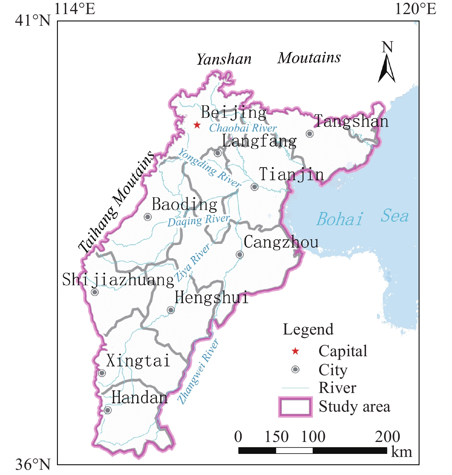
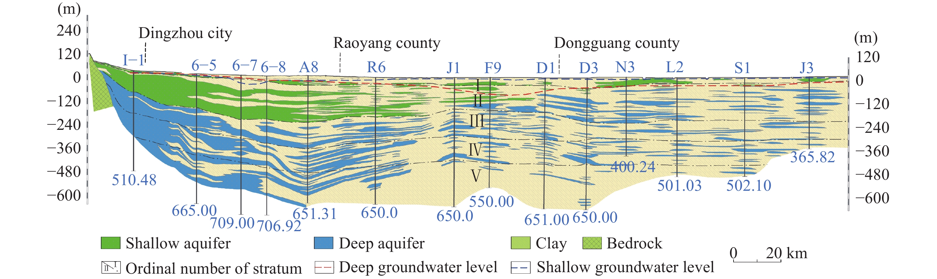
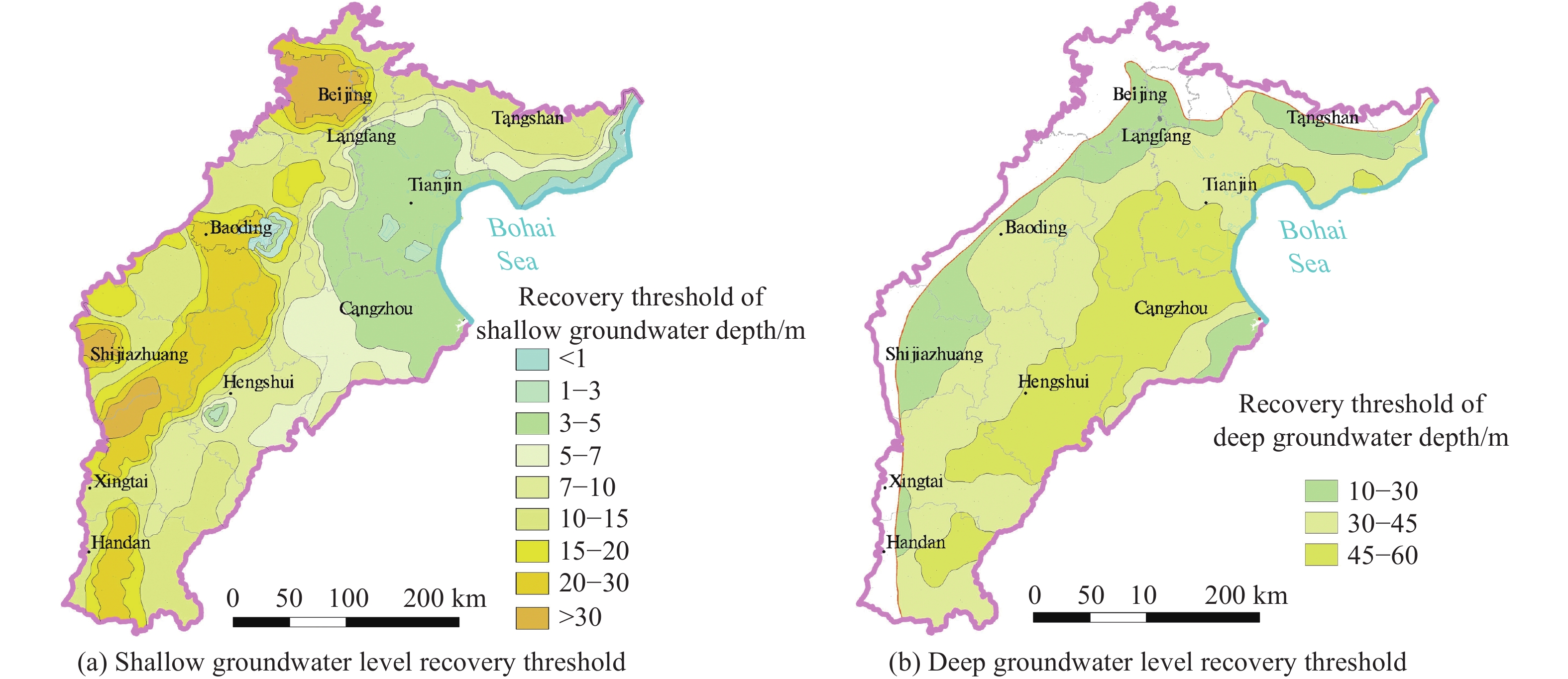
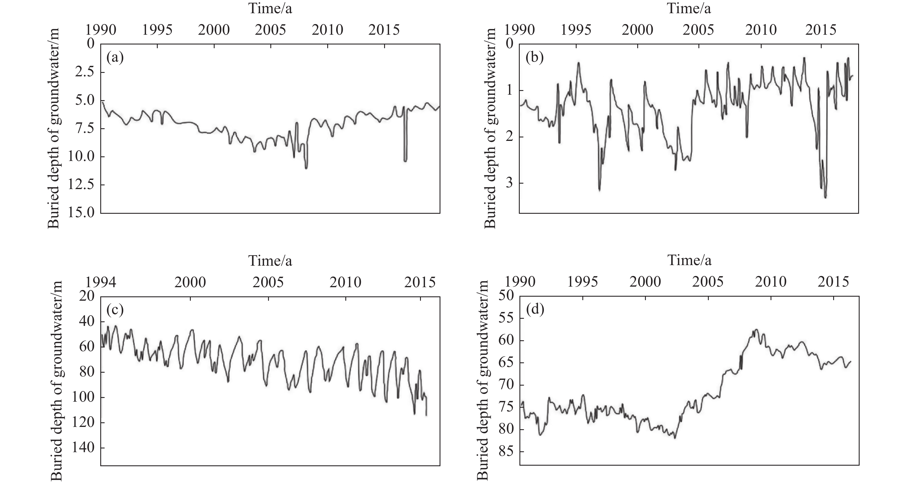
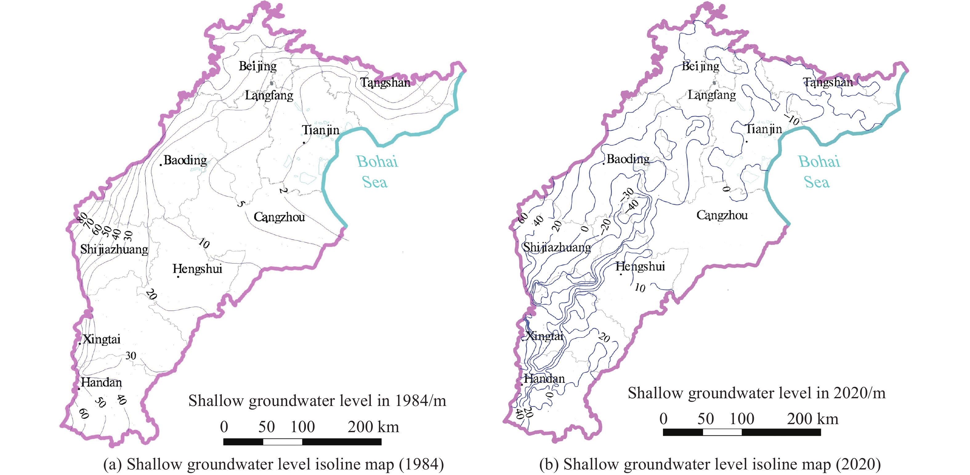
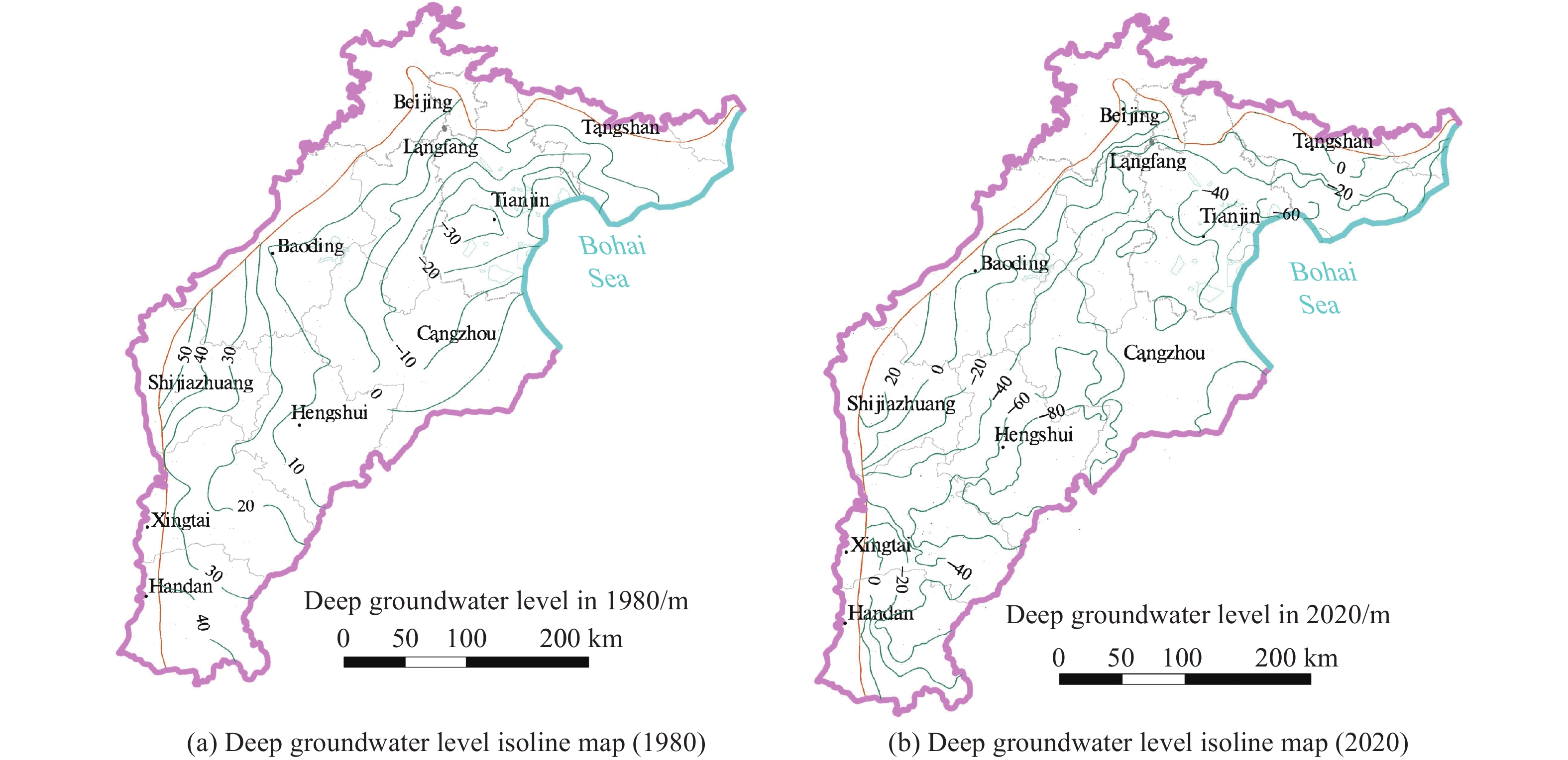
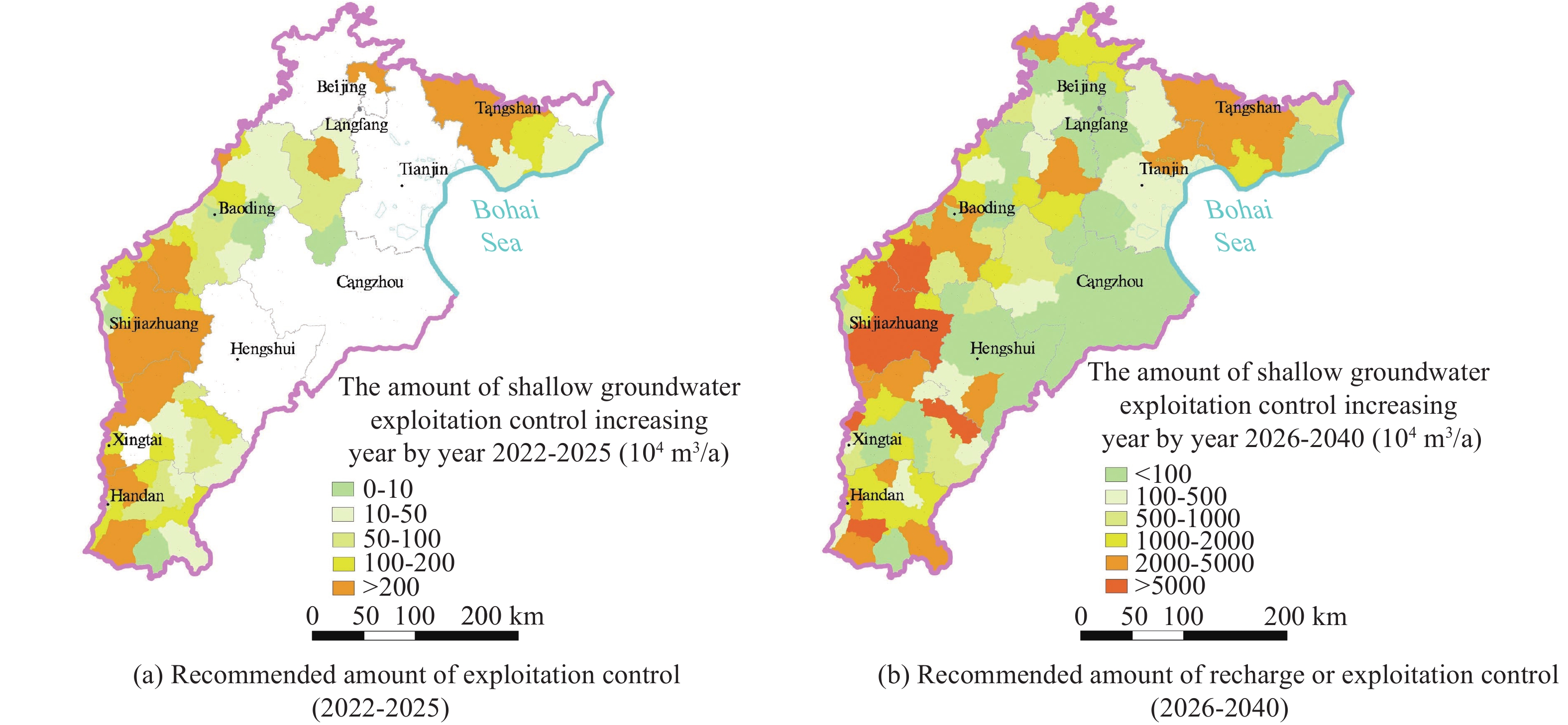
The Beijing-Tianjin-Hebei Plain (BTHP) is the political, economic and cultural center of China, where groundwater is the main source of water supply to support social and economic development. Continuous overdraft of the resources has caused a persistent decline of groundwater level and formed a huge cone of depression at a regional scale. This paper addresses current groundwater situation over the BTHP area. The paper also delineates the groundwater flow field, using groundwater level data, in order to provide an effective method for the restoration of groundwater level and associated water resources management. Based on the analysis of multiple factors, such as groundwater level, soil salinization, ground subsidence, groundwater recharge and storage, urban underground space security, formation of fractures, and seawater intrusion, the threshold for groundwater level restoration is defined, and some measures for groundwater over-exploitation management are accordingly proposed. The study shows that: (i) Since the 1980s to 2020, shallow groundwater level in the western part of the BTHP area has dropped by 25 m to 60 m, while the cumulative decline of deep groundwater in the central and eastern regions is in the range of 40–80 m; (ii) The water table of the shallow groundwater within the depression zone over the Western Piedmont Plain should be controlled in the range of 15–30 m below ground level (mbgl), while the depth of groundwater level in large and medium-sized urban areas should be controlled within 20–30 mbgl. The groundwater level in the resource preservation area should be controlled within 10–15 mbgl, and the groundwater level in the area with identified soil salinization in the central and eastern plain should be controlled within 3–10 mbgl. However, for the deep groundwater in the central and eastern plainwater, the main focus of the resources management is to control the land subsidence. The water level in the severe land subsidence area should be controlled within 45–60 mbgl, and in the general subsidence area should be controlled within 30–45 mbgl; (iii) Based on the water level recovery threshold and proposed groundwater overdraft management program, if the balance of abstraction and recharge is reached in 2025, the shallow groundwater abstraction needs to be gradually reduced by about 2×10⁸ m3. Meanwhile, the ecological water replenishment of rivers through the South-to-North Water Transfer Project should be increased to 28.58×10⁸ m3/a, and the deep groundwater abstraction needs to be gradually reduced by 2.24×10⁸ m3. To reach the target of shallow groundwater level in 2040, surface water replacement is recommended with a rate of 25.77×10⁸ m3/a and the ecological water replenishment of rivers in the South-to-North Water Diversion Project should reach 33.51×10⁸ m3/a. For deep groundwater recovery, it is recommended to replace the deep freshwater extraction with the utilization of shallow salt water by 2.82×10⁸ m3 , in addition to the amount of 7.86×10⁸ m3 by water diversion. The results are of great significance to the remediation of groundwater over-exploitation, the regulation of water resources development and utilization, and ecological protection in Beijing-Tianjin-Hebei plain.
Genetic model and exploration target area of geothermal resources in Hongtang Area, Xiamen, China
Chun-lei Liu, Chen-ming Lu, Ya-song Li, Qi-chen Hao, Sheng-wei Cao
2022, 10(2): 128-137. doi: 10.19637/j.cnki.2305-7068.2022.02.003
Abstract(561) FullText HTML (226) PDF(105)
Abstract:
The geothermal resources in Fujian Province are mainly hydrothermal resources of medium-low temperature. To better understand the whole process and conditions of heat control in the middle and deep crust, this study focuses on the analysis of heat accumulation model in Hongtang Area of Xiamen, and the main conditions of the model such as faults and sags are explored and interpreted in detail by using gravity and wide-field electromagnetic methods. 4 main faults (F33, F2, F12 and HT-F1) and 10 secondary faults (HT-F2, HT-F3, HT-F4, HT-F5, HT-F6, HT-F7, HT-F8, HT-F9, HT-F10 and HT-F11) were inferred, and the distribution range of sags was delineated. The convective geothermal system is composed of four components: Heat source, geothermal reservoir, heat-conductive fault and heat retaining cover, which form a quaternary heat accumulation model. According to the model, the intersection of the main faults F12, HT-F1 and F33 can be delineated as the primary target area of geothermal exploration, while the intersection of the secondary faults (F12 and HT-F6; F12 and HT-F2; HT-F9, HT-F10 and F12; F12 and HT-F11; F33 and HT-F3; HT-F8 and HT-F3; HT-F2, HT-F10 and HT-F1) can be delineated as the secondary target area. Borehole DR01, which is located in the primary target area, shows that the water temperature increases from fast to slow in the depth range of 0–500 m, and stays at 36℃ below 500 m. The reliability of the heat accumulation model and the target area was tested via geothermal boreholes, which is of great significance to the exploitation and utilization of geothermal resources in Hongtang Area of Xiamen.
Holistic approach of GIS based Multi-Criteria Decision Analysis (MCDA) and WetSpass models to evaluate groundwater potential in Gelana watershed of Ethiopia
Wondesen Fikade Niway, Dagnachew Daniel Molla, Tarun Kumar Lohani
2022, 10(2): 138-152. doi: 10.19637/j.cnki.2305-7068.2022.02.004
Abstract(826) FullText HTML (341) PDF(92)
Abstract:
Appropriate quantification and identification of the groundwater distribution in a hydrological basin may provide necessary information for effective management, planning and development of groundwater resources. Groundwater potential assessment and delineation in a highly heterogeneous environment with limited Spatiotemporal data derived from Gelana watershed of Abaya Chamo lake basin is performed, using integrated multi-criteria decision analysis (MCDA), water and energy transfer between soil and plant and atmosphere under quasi-steady state (WetSpass) models. The outputs of the WetSpass model reveal a favorable structure of water balance in the basin studied, mainly using surface runoff. The simulated total flow and groundwater recharge are validated using river measurements and estimated baseflow at two gauging stations located in the study area, which yields a good agreement. The WetSpass model effectively integrates a water balance assessment in a geographical information system (GIS) environment. The WetSpass model is shown to be computationally reputable for such a remote complex setting as the African rift, with a correlation coefficient of 0.99 and 0.99 for total flow and baseflow at a significant level of p-value<0.05, respectively. The simulated annual water budget reveals that 77.22% of annual precipitation loses through evapotranspiration, of which 16.54% is lost via surface runoff while 6.24% is recharged to the groundwater. The calibrated groundwater recharge from the WetSpass model is then considered when determining the controlling factors of groundwater occurrence and formation, together with other multi-thematic layers such as lithology, geomorphology, lineament density and drainage density. The selected five thematic layers through MCDA are incorporated by employing the analytical hierarchy process (AHP) method to identify the relative dominance in groundwater potential zoning. The weighted factors in the AHP are procedurally aggregated, based on weighted linear combinations to provide the groundwater potential index. Based on the potential indexes, the area then is demarcated into low, moderate, and high groundwater potential zones (GWPZ). The identified GWPZs are finally examined using the existing groundwater inventory data (static water level and springs) in the region. About 70.7% of groundwater inventory points are coinciding with the delineated GWPZs. The weighting comparison shows that lithology, geomorphology, and groundwater recharge appear to be the dominant factors influence on the resources potential. The assessment of groundwater potential index values identify 45.88% as high, 39.38% moderate, and 14.73% as low groundwater potential zones. WetSpass model analysis is more preferable in the area like Gelana watershed when the topography is rugged, inaccessible and having limited gauging stations.
Comparative analysis of bacterial contamination in tap and groundwater: A case study on water quality of Quetta City, an arid zone in Pakistan
Khan Tanzeel, Akhtar Malik Muhammad, Malghani Gohram, Akhtar Rabia
2022, 10(2): 153-165. doi: 10.19637/j.cnki.2305-7068.2022.02.005
Abstract(719) FullText HTML (273) PDF(56)
Abstract:
Water is an essential element on earth, which provides human a variety of services in domestic use, agriculture, or industries. However, some serious health risks of drinking water are associated with microbial contamination, particularly with fecal matter. Therefore, microbial quality assessment is considered to be a necessary component of water quality assessment. This study investigates microbial contamination of water distributary system around the city by comparing groundwater (GW) and tap water (TW) quality in Quetta city. 31 GW samples and 31 TW samples were collected in the study area during the months of September, October, and November. Fecal coliform test was carried out in laboratory and their average total coliform contamination was computed. Results showed that the TW sample were all contaminated by coliform except for Chiltan town, hence are not considered suitable for drinking without any treatment according to WHO drinking water quality standards. The average coliform concentrations were 12 in Quetta main city, 11.6 in Jinnah town, 5.3 in Satallite town, 10 in Shahbaz town and 5 in Brewery town (0/100 mL CFU) and the TW samples from the three towns were even more contaminated with E.coli. Whereas among the GW, average microbial concentrations were 1.8 in Quetta main city, 2 in Satallite town, 1.4 in Shahbaz town, and 0.4 in Chiltan town (0/100 mL CFU), respectively, which shows that the contamination is occurring within the water distributary pipeline system when the water flows through the pipelines. Moreover, this research will be valuable for researchers and administrative authorities to conduct elaborative studies, and develop new policies to prevent further deterioration of drinking water in the water distribution system by pathogenic microorganisms and ensure safe drinking water to the public of Quetta city.
Research on the characteristics and influencing factors of terrestrial heat flow in Guizhou Province
Shuai-chao Wei, Feng Liu, Wei Zhang, Gui-ling Wang, Ruo-xi Yuan, Yu-zhong Liao, Xiao-xue Yan
2022, 10(2): 166-183. doi: 10.19637/j.cnki.2305-7068.2022.02.006
Abstract(682) FullText HTML (266) PDF(41)
Abstract:
Terrestrial heat flow is an important physical parameter in the study of heat transfer and thermal structure of the earth and it has great significance in the genesis and development and utilization potential of regional geothermal resources. Although several breakthroughs in geothermal exploration have been made in Guizhou Province. The terrestrial heat flow in this area has not been properly measured, restricting the development of geothermal resources in the province. For this reason, the terrestrial heat flow in Guizhou was measured in this study, during which the characteristics of heat flow were determined using borehole thermometry, geothermal monitoring and thermal property testing. Moreover, the influencing factors of the terrestrial heat flow were analyzed. The results show that the thermal conductivity of rocks ranges from 2.0 W/(m·K) to 5.0 W/(m·K), with an average of 3.399 W/(m·K); the heat flow varies from 30.27 mW/m2 to 157.55 mW/m2, with an average of 65.26 ± 20.93 mW/m2, which is slightly higher than that of the average heat flow in entire land area in China. The heat flow in Guizhou generally follows a dumbbell-shaped distribution, with high values present in the east and west and low values occurring in the north and south. The terrestrial heat flow is related to the burial depths of the Moho and Curie surface. The basaltic eruptions in the Emeishan led to a thinner lithosphere, thicker crust and lateral emplacement, which dominated the basic pattern of heat flow distribution in Guizhou. In addition, the dichotomous structure of regional active faults and concealed deep faults jointly control the heat transfer channels and thus influence the terrestrial heat flow.
Spatial confirmation of termite mounds as Bio-geo indicator for groundwater occurrences using ground magnetic survey: A case study from Perambalur Region of Tamil Nadu, India
A Muthamilselvan, B Preethi
2022, 10(2): 184-195. doi: 10.19637/j.cnki.2305-7068.2022.02.007
Abstract(560) FullText HTML (195) PDF(50)
Abstract:
Termite mounds are conventionally surmised as one of the best bio-geological indicator for groundwater occurrence in places where they inhibit. Ground magnetic survey was carried out to prove the assumption about termite mounds as an important indicator for groundwater exploration. Occurrences of 18 Termite mounds were mapped using handheld GPS to identify the suitable trend for magnetic survey. After considering all the criteria such as power lines, fences and fracture system, termite mound 2, 12 and 18 were selected in the NNE-SSW trend, and the ground magnetic survey was conducted in ESE-WNW direction which is perpendicular to the trend of the termite mounds using Proton Precession Magnetometer. Totally, 99 samples were collected with 5 m sampling interval and 50 m profile interval over an area of 22 500 sq.m. The magnetic values varied from –7 363 nT to 898 nT with the mean of –331 nT. Processed map of reduction to Equator indicates the presence of NNE-SSW and WNW-ESE magnetic breaks. Analytical signal map designated the presence of magnetic low in the WNW-ESE direction which coincides spatially with the magnetic breaks. The magnetic profile lines have also brought to light the structurally weak zones. Causative body depth range was estimated using power spectrum and Euler method which are from 120 m to 40 m and <20 m to >100 m, respectively. The present study appreciably brings out the spatial relationship between the termite mounds and the hydro-fractures. This confirms the assertion with regard to termite mounds as an effective tool for groundwater exploration.
Numerical simulation of operation performance on production and injection of a double well geothermal system in Kailu Basin, Inner Mongolia
Yu-kun Sun, Feng Liu, Hua-jun Wang, Xin-zhi Gao
2022, 10(2): 196-208. doi: 10.19637/j.cnki.2305-7068.2022.02.008
Abstract(842) FullText HTML (319) PDF(46)
Abstract:
Inner Mongolia is abundant in geothermal resources, but the development and utilization of medium-depth geothermal resources for clean heating in winter is still in the preliminary stage compared with the neighboring provinces. In this paper, a recently developed geothermal heating system using the Mesozoic sandstone reservoirs in Baokang of Kailu Basin, Eastern Inner Mongolia was investigated, a three-dimensional geological model of a pair of production and injection well was established, and numerical simulations on the long term operation performance were conducted and verified by pumping test and water level recovery test data. The effects of flow rates, the direction of wells, injection temperature and ratios on the flow field and water level in the thermal reservoir were analyzed. The results show that considering a 30-year operation period and a production rate from 90 m3/h to 110 m3/h, the optimum well spacing can be increased from 225 m to 245 m, with an average value of 235 m. With the decrease of the injection temperature, the cold front of the injection water has an increasing influence on the temperature in the production well. A complete injection or the principle of production according to injection is recommended in order to maintain the long-term operation stability. In addition, the location of the injection well should be arranged in the downstream of the natural flow field. The present results can provide a useful guide for the optimum design and performance prediction of geothermal wells, thus maintaining the production and injection balance and promoting the sustainable development and utilization of medium-depth and deep geothermal resources.

Welcome to Journal of Groundwater Science and  Engineering!

Quick Submit

Online Submission   E-mail Submission